

CAPE
-
Posts
36,844 -
Joined
-
Last visited
Content Type
Profiles
Blogs
Forums
American Weather
Media Demo
Store
Gallery
Everything posted by CAPE
-
I hate rooting for this team
-
LOL
-
Wasn't the greatest pass, but he should have caught it. Lamar is off today. He never runs anymore. I guess his hammy/knee are holding him back. Otherwise Monkon is also a candidate to be fired.
-
That's usually how it happens when they lose. Beat themselves. They are pretty good at it.
-
Inexcusable special teams gaffes. Gifts.
-
Justice Hill is inactive. That should mean increased touches for Keaton Mitchell. Given how poor the Ravens OG play has been- and the Browns standout DL, Henry will probably find it difficult to get going. Mitchell has the combo of quickness and speed that can make the difference. He damn well better be a big part of the game plan.
-
Fresh Bluefin Tuna. Paid 14 bucks. Imagine what this would have cost in a restaurant. Seasoned with salt, pepper, and Japanese Seven spice. Fuck yeah.
-
There could easily be some error at this range in the exact positioning/orientation of the long wave features. I wouldn't call it a can kick but given the currently advertised position of the Pac trough and the downstream ridge over AK towards D15, its not hard to imagine a western US trough for a time at the beginning of Dec.
-
Always hard to tell with you lol. The point stands.
-
I need this in my life. Triple Decadence World Wide Stout 4pk, 12 fl. oz. Bottles Raise a glass to 30 years of off-centered innovation with Dogfish Head’s Triple Decadence World Wide Stout. This 15% ABV imperial stout is aged in wood barrels from three iconic barrel-aged brews: our Palo Santo Marron Ale and Let’s Get Lost Whiskey along with Sam Adams’ Utopias. With notes of rich coffee, vanilla, and warming sweetness, this limited release ale offers a port-like depth and a full-bodied finish. It’s bold, complex, and brewed to age. Just like the journey it celebrates..
-
Click bait. WB CFS is useless. That's a single run. That model is volatile af and changes like the wind. Only somewhat useful when averaged over several runs. If you look at it on Tropical Tidbits it is the average of the last 12 runs.
-
Latest edition of the Euro Weeklies continues to advertise a favorable h5 look for early Dec( and beyond fwiw).
- 827 replies
-
- 15
-

-

-

-

-
1.2" for the day Had a tenth in the morning and the rest was from the storm last night.
-
Pummeled. Sounds like July out there.
-
Awful. And why did Keaton Mitchell disappear again after getting some chunk plays? Fucking Harbaugh. Wasn't pretty, but its a win. TY Vikings for so many gifts. Onward.
-
Nice downpour happening.
-
I did the same. As I am looking out the window its ripping fatties(oak leaves) and covering up the area I just cleared.
-

Best Mid-Atlantic winter storm of the last 50 years
CAPE replied to AnEndlessMaze's topic in Mid Atlantic
Dec 2009, because it was KU that occurred before Xmas(very unusual) and it kicked off the best snow season of my lifetime. Modoki Nino with epic NA Blocking that developed early and sustained through winter. My answer may have been different earlier but at this juncture that's the one lol. -
That's way too far out for an extended product. Stick with the early Dec period- much more likely to have a clue. H5 for the first week of Dec continues to look good: -NAO, which as modeled on the ens runs develops in mid/late Nov but with a bit of a hostile Pac, is still present with big improvement in the PNA/EPO domain.
-
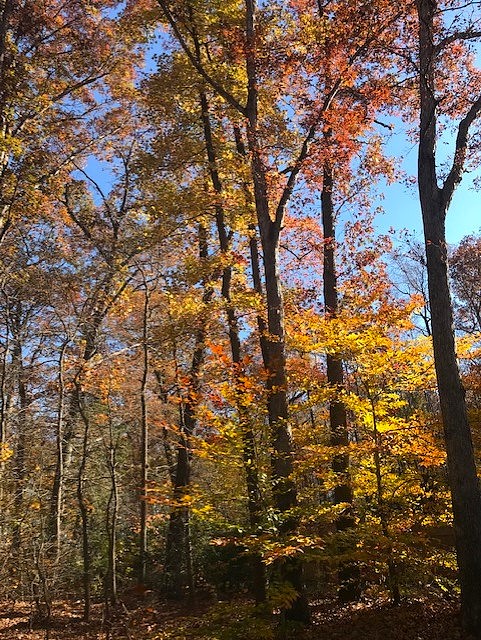
Peak to past peak here, but still plenty of leaves yet to fall. Spent a few hours today blowing/raking to keep ahead of it.
- 396 replies
-
- 10
-
-
Maybe a couple hundredths. Fine with me as I have a ton of leaves to blow. Nice and dry..
-
The Ravens weren't very good that season and missed the playoffs, but that game was wild in the snow.
-
Imo the extended products are 'useful' a week to 10 days beyond day 15 of the latest ens runs. Beyond that.. crapshoot.
-
31 first freeze!
-
Today's edition of the Weeklies for the mid Dec period- hey we can dream a little right? Why not be optimistic heading into the first third of winter. Easy to be pessimistic.
- 827 replies
-
- 11
-
