

CAPE
-
Posts
30,921 -
Joined
-
Last visited
Content Type
Profiles
Blogs
Forums
American Weather
Media Demo
Store
Gallery
Everything posted by CAPE
-
Yeah the biggest issue with winter drought for most in this forum is it = little snow lol
-
Cant imagine its still abnormally dry here, but I guess its possible. I ended up with 3.8" for Jan.
-

Southern MD / Lower Eastern Shore weather discussion
CAPE replied to PrinceFrederickWx's topic in Mid Atlantic
Was that the total for the whole event? I saw some reports from southern DE of up to 7" from Friday night alone. I would love to see some other event totals from the lower Delmarva. -
Southern MD / Lower Eastern Shore weather discussion
CAPE replied to PrinceFrederickWx's topic in Mid Atlantic
You might get another 3-6 today. -
Southern MD / Lower Eastern Shore weather discussion
CAPE replied to PrinceFrederickWx's topic in Mid Atlantic
Another 20-30 miles NW and I am in the bullseye I sincerely hope SBY and the beaches get 6"+. I had such a great time at Rehoboth for that cold powder bomb in early Jan. -
Southern MD / Lower Eastern Shore weather discussion
CAPE replied to PrinceFrederickWx's topic in Mid Atlantic
Here are some official totals from Mount Holly for the 1/7 storm for southern DE- ...SUSSEX COUNTY... OCEAN VIEW 13.5 625 PM 1/07 TRAINED SPOTTER SELBYVILLE 13.0 604 PM 1/07 TRAINED SPOTTER SEAFORD 9.0 550 PM 1/07 TRAINED SPOTTER LAUREL 8.0 538 PM 1/07 DEOS ELLENDALE 6.6 537 PM 1/07 DEOS 7 E SELBYVILLE 6.5 600 AM 1/08 COCORAHS STOCKLEY 6.2 537 PM 1/07 DEOS BRIDGEVILLE 6.1 538 PM 1/07 DEOS 1 W MILLSBORO 6.1 800 AM 1/08 COCORAHS BLADES 6.0 545 PM 1/07 TRAINED SPOTTER NASSAU 5.8 600 PM 1/07 DEOS I was in Rehoboth and there was unofficially 10" there for the 1/7 event. Lewes I thought I saw a report of 12" somewhere. I don't have any official totals for the 1/30 event, but I know there was a 2-4" area in southern DE for that one. Hope this helps! -
Southern MD / Lower Eastern Shore weather discussion
CAPE replied to PrinceFrederickWx's topic in Mid Atlantic
That one storm made this wretched winter bearable. Who would have thunk it- the best pure snow event of the season for our region occurred at the beaches. Cold dry powder with drifting too. I had 2 great days at Rehoboth, then came home to 6" on the ground and that stuck around for 3 more days. I got a nice snow hike in at Tuckahoe. Good 5 day stretch of winter, and in early January to boot. But that was all she wrote. -
Southern MD / Lower Eastern Shore weather discussion
CAPE replied to PrinceFrederickWx's topic in Mid Atlantic
Nope. 1.2" here. Hoping to see some reports from Delaware. Best banding has persistently been in Sussex County. Must be some 4' amounts there. -
Southern MD / Lower Eastern Shore weather discussion
CAPE replied to PrinceFrederickWx's topic in Mid Atlantic
Rehoboth is completely awesome. No official measurement but definitely 8+ with lots of drifts. Winter wonderland at the beach plus bar hopping. So fun. -
Southern MD / Lower Eastern Shore weather discussion
CAPE replied to PrinceFrederickWx's topic in Mid Atlantic
Took these out in front of the hotel in Rehoboth.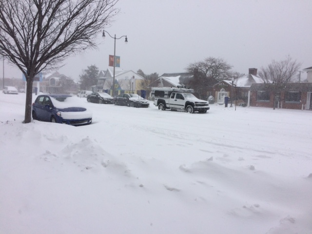
-
Southern MD / Lower Eastern Shore weather discussion
CAPE replied to PrinceFrederickWx's topic in Mid Atlantic
Looking pretty good. Root for the NAM of course lol. Even if it is overdone, almost all other guidance has at least a few inches down your way and over to the beaches. -
Best Mid-Atlantic winter storm of the last 40 years
CAPE replied to PrinceFrederickWx's topic in Mid Atlantic
They were not similar at all in many respects. 1996 was colder, and even though it flipped to sleet for many, it had a long duration cold conveyor of moderate snow after the shallow warm layer moved off. For the storm this year, either you were in the deform band or you weren't. It rapidly weakened when it finally pivoted east, so those that were solidly dry slotted didn't pick up much more accumulation. Also places on the lower eastern shore(Salisbury) had mostly rain from the storm this past January. Pretty sure they did much better in the 96 storm. -
Best Mid-Atlantic winter storm of the last 40 years
CAPE replied to PrinceFrederickWx's topic in Mid Atlantic
15" here for the Jan storm this winter. Dry slotted. 1996 I had 20" despite hours of sleet in the middle. -
Feb 2003 Feb 1983 Feb 5, 2010 Dec 2009 Jan 1996 Feb 10, 2010 Jan 1987 Jan 2016
-
2009-2010 was my fav winter. There are individual events in other winters I liked better than any one of the 3 biggies of that winter, but there was just something magical about it. And getting the big storm before Xmas was something I had never experienced. That was awesome, and just gave me the feeling we were on to something special. Also, the late Jan storm was awesome- 15 degrees and 7" of pure fluff, and the Feb 5th event was already on the radar. Great winter.
-
Southern MD / Lower Eastern Shore weather discussion
CAPE replied to PrinceFrederickWx's topic in Mid Atlantic
The low over the SE moving up off the coast tomorrow and Monday may get close enough to get some snow into your area. Temps may be marginal though. Odds are sometime over the next 10 days you will get some snow there. -
Southern MD / Lower Eastern Shore weather discussion
CAPE replied to PrinceFrederickWx's topic in Mid Atlantic
Per 21z RAP, best accums still lower So MD and Eastern shore. Oddly this latest run has a local bulls eye over me lol. In general I think this aligns with the ongoing forecast of 1-3". -
Southern MD / Lower Eastern Shore weather discussion
CAPE replied to PrinceFrederickWx's topic in Mid Atlantic
21z RAP -
Southern MD / Lower Eastern Shore weather discussion
CAPE replied to PrinceFrederickWx's topic in Mid Atlantic
Not seeing that. -
Southern MD / Lower Eastern Shore weather discussion
CAPE replied to PrinceFrederickWx's topic in Mid Atlantic
Yup. The 5" on the Euro seems unlikely..thats the Boom potential with this. 1-2 seems doable. If the dynamics arent there, I could see it raining for hours as the temps slowly fall, with some mood fllakes at the end. -
Southern MD / Lower Eastern Shore weather discussion
CAPE replied to PrinceFrederickWx's topic in Mid Atlantic
Dont look at the 16z RAP...basically nada for SBY eta- 17z looks better, and its the extended RAP so its out of its range a tad. It also tends to run warm, but the warm temps going in and the short window are a concern. -
Southern MD / Lower Eastern Shore weather discussion
CAPE replied to PrinceFrederickWx's topic in Mid Atlantic
12z Euro looks great esp for the lower shore folks...5" for SBY to coastal DE. 3-4" Lower So MD up to Dover. -
Southern MD / Lower Eastern Shore weather discussion
CAPE replied to PrinceFrederickWx's topic in Mid Atlantic
I like the Euro solution..it gives me about 2" up here, plus it gives Salisbury 4". WIN -
Best Mid-Atlantic winter storm of the last 40 years
CAPE replied to PrinceFrederickWx's topic in Mid Atlantic
PD II probably. Hard to pick honestly. '79, 83, 96, and the 3 biggies in '09-10 I put ahead of this storm. Its all based on location though! -
Southern MD / Lower Eastern Shore weather discussion
CAPE replied to PrinceFrederickWx's topic in Mid Atlantic
Per Euro you get more than Westminster ha!