CAPE
-
Posts
36,848 -
Joined
-
Last visited
Content Type
Profiles
Blogs
Forums
American Weather
Media Demo
Store
Gallery
Everything posted by CAPE
-
Mount Holly mentions the potential in their morning AFD, but low probability for any convection to initiate. For Wednesday, a weak area of low pressure passes by to the north as it moves from upstate NY into New England. An initial round of showers and storms associated with the system`s warm front will be moving out through the first part of the morning with skies then clearing and temperatures shooting up as the area breaks into the system`s warm sector. Expect afternoon highs generally in the low to mid 80s across the area except 70s right near the immediate coast and over the southern Poconos. Dew points will climb into the low to mid 60s through the late morning but then should actually start to come down in the afternoon as a very weak cold front starts to move through and the winds turns more westerly. During the warmest part of the day dew points should be mainly in the upper 50s to low 60s which isn`t too high. There could be some isolated afternoon showers/storms developing but these would be few and far between as it should otherwise be dry through the latter part of the day. It is worth mentioning though that should any showers/storms develop they could become severe as winds aloft will will be quite strong with inverted-V soundings in the lower levels. Damaging winds would be the threat.
-

2024 Mid-Atlantic Garden, Lawn, and Other Green Stuff Thread
CAPE replied to mattie g's topic in Mid Atlantic
The holes they bore are 3/8 to 1/2 inch diameter. Most traps the holes are drilled to half inch. Good luck! -
2024 Mid-Atlantic Garden, Lawn, and Other Green Stuff Thread
CAPE replied to mattie g's topic in Mid Atlantic
Drilled on an upward angle. The idea is once the bee gets in, it only sees light at the bottom and goes there thinking its the way out. -
Some persistent light to moderate rain this afternoon after the spits and drizzle of this morning. Up to 0.65" for the event.
-
Dw, we go from 50s and damp right back to 80s and humid in a blink. Seems impossible to get a few sunny days in the low 70s with a nice breeze and low dews.
-
The rain here has helped the areas I had already been watering, but outside of that a good soaking rain is needed.
-
A few light sprinkles this morning. Mostly an annoyance and doing nothing for the dry conditions. 0.44" for the 'event' so far. Just enough to dampen the top eighth inch of soil. Powdery dry under that.
-
Don't forget the mushrooms. For pictures I mean.
-
2024 Mid-Atlantic Garden, Lawn, and Other Green Stuff Thread
CAPE replied to mattie g's topic in Mid Atlantic
@nw baltimore wx Here is one located on the deck skirting on the front of my house- it's a hot spot. All those bees captured since that initial hot spell in April. -
2024 Mid-Atlantic Garden, Lawn, and Other Green Stuff Thread
CAPE replied to mattie g's topic in Mid Atlantic
Google Carpenter bee traps. You can buy them or make your own. As the owner of a log cabin in an area with plenty of carpenter bees, I've found these to be the only effective solution. Key is to place them in areas where bees tend to drill- if there are previous infestations, puff delta dust (or pump WD40 lol) in the holes-which are up to a foot long and always take a 90 degree turn from the opening. Once the queen/larvae are eradicated, plug the hole and place a trap there. Best done at the end of summer/early Fall. Next Spring when they return, you got em'. It's effing glorious. If you plug the hole and leave anything alive in there, the woodpeckers will come and peck out the whole channel, requiring repair of the wood. I made all these mistakes years ago not knowing the nature of it. -
After a brief heavy downpour this morning, been getting on and off mostly light rain. All adds up to 0.34". More than I expected over here based on the 12z and 18z runs yesterday. Looks like its moving out for now. Maybe I can get a little outside work done later this afternoon.
-
Just had a heavy downpour here. Picked up a quick tenth of an inch. Pretty surprised to see anything this morning as most guidance had any shower activity dissipating as it moved eastward into the HP. It is actually weakening and breaking apart but managed to get underneath a heavier cell. Most rain I have seen in weeks.
-
Raw out there now. 52 and mostly cloudy.
-
Rainfall generally looks pretty meager here across guidance through the weekend. I'll probably do a significant watering tomorrow morning in anticipation. Soil is super dry now.
-
Sipping on this for (early) Friday HH. Very good. https://lonepinebrewery.com/beers/collaborations/imperial-maple-sunday/
-
Beautiful day. Been no higher than 60 with a stiff east breeze, partly sunny.
-
Isn't this the May MR/LR thread? December a hella long way off. What a start lol.
-
88 here. Overperformer.
-
Os need a closer who isn't 35 and trying to hang on to something that's gone. Brutal loss to lose 2 out of 3 to the lowly As.
-
80 and humid in late April is so easy with a simple shift in the flow from NE to S/SW. It was 55 yesterday. It's gonna get really gross(as usual) in the coming months.
-
Monkey brains. Definitely no resemblance to an orange, other than the size. I guess that's it.
-
Ravens might have the most talented/deepest secondary in the league on paper after this draft. Filled needs at OT, WR, and LB too. Typical DeCosta brilliance.
-
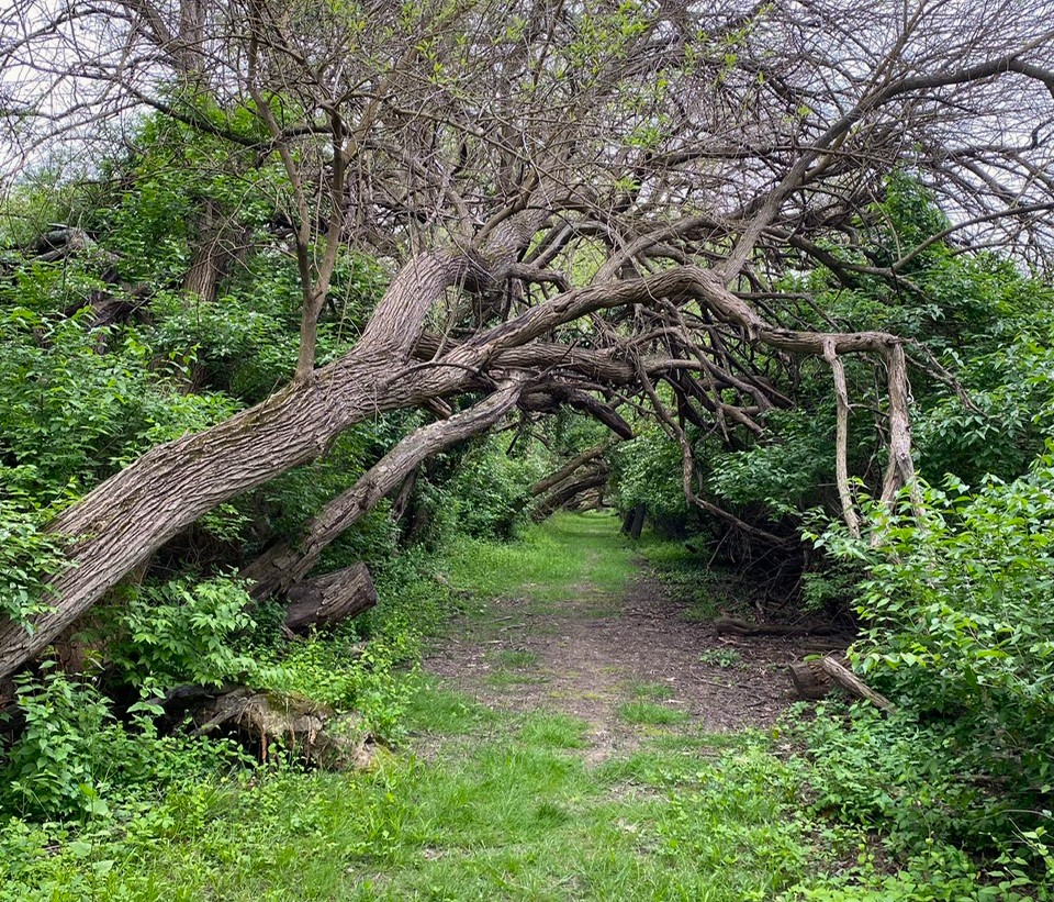
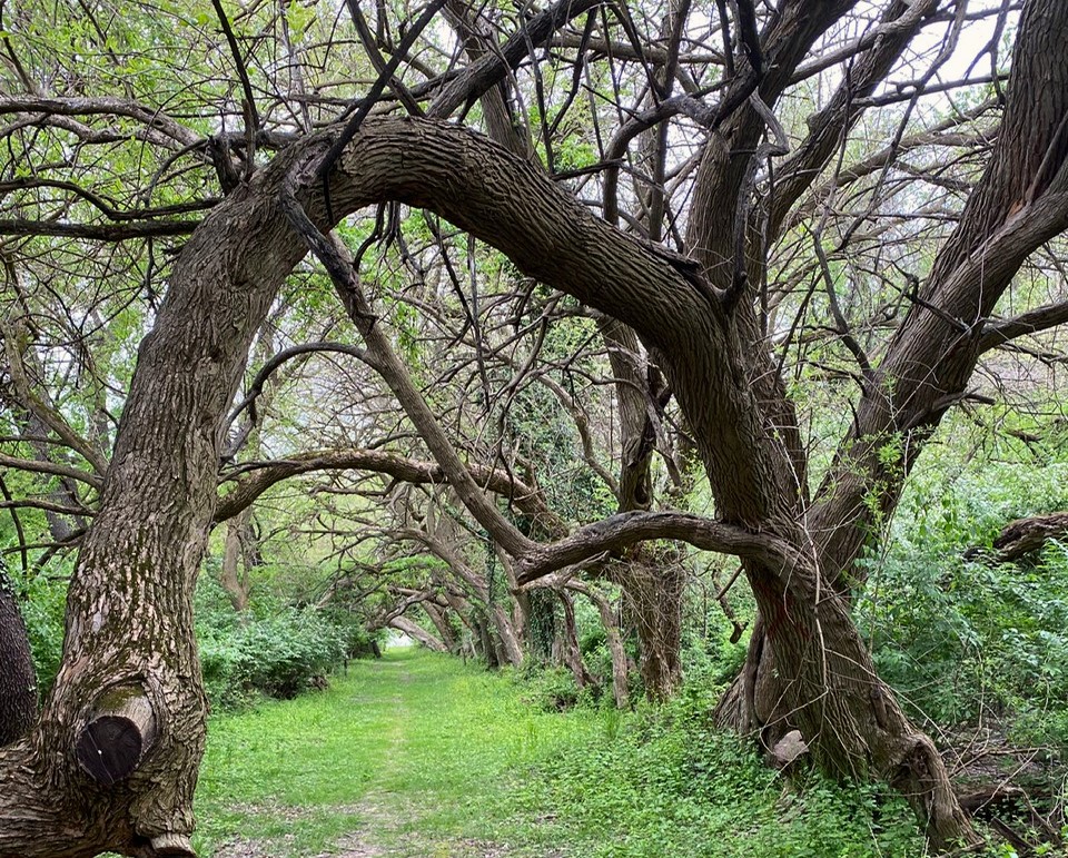
Some shots from Wye Island today. A bit of a hidden gem apparently. Beautiful place. Features the Osage Orange trees forming a tunnel(way more amazing in person) and a 275+ year old Holly tree, also more impressive in person. The 'new' Wye Oak I suppose. eta- https://www.visitmaryland.org/listing/attraction/wye-island-natural-resource-management-area


- 141 replies
-
- 11
-

-
I went there today. Oddly, same weather, which was awesome. It is a great spot and I haven't been there for years. That Osage trail is so cool with those trees forming a tunnel. Sort of otherworldly.
-
55 here with some spits and drizzle. 25 degrees warmer tomorrow. Hell of a southerly flow on the other side of that warm front.