

40/70 Benchmark
-
Posts
67,735 -
Joined
-
Last visited
Content Type
Profiles
Blogs
Forums
American Weather
Media Demo
Store
Gallery
Posts posted by 40/70 Benchmark
-
-
4 minutes ago, weatherwiz said:
gotcha...should have been more clear. Meant it could be good for those riding the line as it at least keeps them in the game, it doesn't completely end hope (accounting for the possibility of more favorable ticks).
But if the NAM has the best handle on the convection....and it is furthest north and warmest, why does the keep me in the game???
-
1 minute ago, dryslot said:
He's hitting the high gravity scuba tanks early today.
I think he is just excited about the convection in the midwest and knows that no one in this thread would care (the severe thread is undoubtedly a morgue), so he's obfuscating.
-
 1
1
-
-
17 minutes ago, weatherwiz said:
The NAM may be the way to go with this. It's doing a damn good job I think with the handling of the convection and evolution of the convection across the Ohio Valley. The NAM is quite scary today with the extent of the potential for severe weather and strong tornadoes. If the convection today becomes as robust as the NAM indicates that is good news for the interior and maybe for areas that are borderline currently.
Just now, weatherwiz said:Well I guess it depends on perspective/expectations

Someone somewhere is going to get whacked pretty good, unfortunately it's probably a small amount of people and a very small percent of the forum so I can understand the excitement may not be high.
But at least from a meteorological perspective, this is going to be a blast to watch unfold. Storms like this though are a phenomenal learning tool. I wish in school there was a class or course (maybe there is in grad school) then was dedicated to studying historical storms. Just watching how everything evolves, interacts, and how all the processes involved lead to the evolution...anyone interested in forecasting could substantially boost their knowledge from these systems.
You aren't making any sense....you are implying that the NAM has the best handle and it would be good news for those riding the line if it is right, but its the most northern and lame solution for those on the line....then when asked, you admit that it would only be good for the moose.
-
10 minutes ago, weatherwiz said:
The NAM may be the way to go with this. It's doing a damn good job I think with the handling of the convection and evolution of the convection across the Ohio Valley. The NAM is quite scary today with the extent of the potential for severe weather and strong tornadoes. If the convection today becomes as robust as the NAM indicates that is good news for the interior and maybe for areas that are borderline currently.
Then why does the NAM solution blow?
-
35 minutes ago, WinterWolf said:
Wouldn’t that be the southern periphery? If everybody north of you is increasing/getting more…wouldn’t that put you on the southern periphery? Just trying to picture what you mean?
Northern periphery of BOX overage area...southern periphery of snow shield.
-
 1
1
-
 1
1
-
-
BOX must be riding the NAM.
-
1
-
-
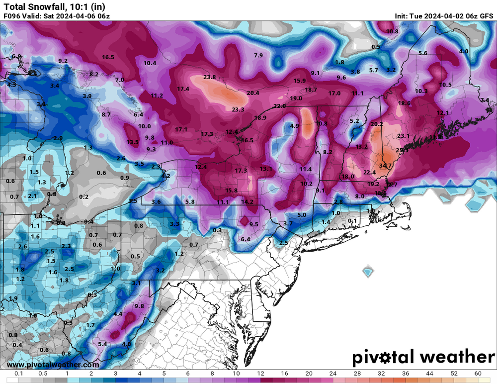
Man...that 06z EURO is cold. 11.1" here now on the Kuchie and 5" on the +DC.....not sure how long BOX can ignore that-
-
1
-
-
Just now, MaineJayhawk said:
I pull it out when the power goes out
Man, too easy...won't bother
-
1
-
4
-
-
6 minutes ago, CoastalWx said:
They’ll toss it anyways.
3 minutes ago, HoarfrostHubb said:They will just toss it anyway
I don't think we will have to worry about board clearing intervals this week.
-
2 minutes ago, ORH_wxman said:
I’m pretty surprised there’s no watch for N ORH county. Guess they think it’s below 50% chance for 6”+ there. Might not be a large enough area too, but they may have to issue one if 12z stays on the colder side.
Yea, I would be about ready to go Watch there.
-
2 minutes ago, CoastalWx said:
They kept much of the discussion from yesterday. #saveitforthenextshift
Eleanor back?
-
4 minutes ago, Lava Rock said:
I've got a handy from a handsome genny. He usually wheels me out then puts a hurting on me while folding me over the table. I leave the back door open. Poor mans shelter but I only do this when I'm feeling like a bad boy. Does everyone else open up the hiny to a handsome genny or do they leave it uncovered and hope for the best
Time to spring into the offseason.

-
2
-
-
BOX must be looking forward to my obs this week....right on the edge of the snow shield at the northern periphery of the coverage area.
-
1
-
-
5 minutes ago, HoarfrostHubb said:
Now if you post another of thoze gonzo Narcan maps, that's a different story
This is in fact inches BTW...

-
1
-
 1
1
-
-
2 minutes ago, HoarfrostHubb said:
Yep That's all I am looking for
Yea, good qualitative tool more so than quantitative.
-
3 minutes ago, 40/70 Benchmark said:
Yea.
I think this is reasonable attm.

Caveat being I would be more inclined to utilize Kutchie in the hills...so maybe 6-12" N ORH hills....3-6" for my area.
-
1
-
-
Just now, ORH_wxman said:
If you get one more tick colder, then you’ll be in big snows I think…right now it’s still a lot of sleet contamination.
Yea.
I think this is reasonable attm.
-
1
-
-
1 minute ago, 40/70 Benchmark said:
I agree with you. The Kuchie maps keep getting more aggressive, but the +depth change maps are chilling at around 3". That is a flag....tells me you need to be around 1K to see those Kuchie amounts.
Just now, Chrisrotary12 said:Question: when y’all referring to the MA/NH border….. the 0-200’ ASL part or the 1,000’ above ASL part? Lol
-
1
-
-
2 minutes ago, DomNH said:
Yes I know lol I just feel like our ceiling is going to be maybe 2-4’’ of slush tomorrow night.
I agree with you. The Kuchie maps keep getting more aggressive, but the +depth change maps are chilling at around 3". That is a flag....tells me you need to be around 1K to see those Kuchie amounts.
-
 1
1
-
-
Clown maps are garbage....most of use here undertand that, but for folks near the border there is still value in that they are an indicator for trends.
-
2
-
-
17 minutes ago, DomNH said:
Problem with those GFS clown maps in this area is that most of what falls after 12z Thursday, if it’s even snow, probably isn’t accumulating much, especially on pavement. Heaviest rates are Wednesday night into Thursday which could bring a few sloppy inches but anything after that I’m skeptical. The snow depth maps aren’t all that impressive outside of the elevated areas.
I wasn't taking the map at face value when I posted about it so much as reflecting on the fact that it treneded southward again.
Clearly I am not getting 2' of snow.
-
1
-
-
1 minute ago, MJO812 said:
Wow (pleads with self not to do it)
-
1
-
4
-
-
4 hours ago, Ginx snewx said:
Congrats Jeffafafafa Dendrite RayRay, Euro
1 hour ago, CoastalWx said:Euro looks unimpressed in SNE. Nice hit for SW Maine though.
Lol
-
6 hours ago, AstronomyEnjoyer said:
Shit, I lost track, are you a military guy (or previous)?
Marine vet.

Significant Miller B Nor'easter watch, Apr 3rd-4th
in New England
Posted
The UCONN fans call into Felger and Mazz and do this....they know that no one here gives a rat's ass, so they try to inconspicuously find a way to link it to one of the major 4 sports teams and Felger roasts them