

40/70 Benchmark
-
Posts
67,735 -
Joined
-
Last visited
Content Type
Profiles
Blogs
Forums
American Weather
Media Demo
Store
Gallery
Posts posted by 40/70 Benchmark
-
-
11 minutes ago, dendrite said:
HREF GW in E NH/SW ME
Puts down about 11" here.
-
 1
1
-
-
1 minute ago, DomNH said:
Kuchera isn’t reliable on the best of days.
Depends....
-
4 minutes ago, Weathernoob335 said:
Despite this it still looks like a decent amount of snow on kuchera, but is that even reliable in these marginal storms? The last storm we got says not even close, hrrr was also bullish and way off last storm for me
If you have some elevation, then Kuchera may have some validity...but it can struggle with picking up mid level warmth.
-
Just now, Weathernoob335 said:
Was just saying this morning it's probably going to sleet to high heaven at my location, that may actually happen, yikes
The dry slot will race in, too.
-
2
-
 1
1
-
-
NAM is never, ever too warm in the mid levels. Not a good sign.
-
1 minute ago, DomNH said:
Looking at the soundings it's either mostly sleet or shitty rimed flakes at best. H7 remains right about at 0c throughout the overnight and then the DGZ dries out once it tries to flip.
Yea, well there is a reason we are only getting like 2".
-
Never want LBSW or LBW.
-
Just now, ineedsnow said:
qpf is really low on the NAM..
And Euro. Skunked ULL....beware.
-
1
-
1
-
-
Just now, ineedsnow said:
you go over to snow at hr30
2am....eh.
-
1 minute ago, ineedsnow said:
NAM is still really warm aloft sleet to Quebec?
It will nail it...always does.
-
3 minutes ago, Prismshine Productions said:
Boston commute would be grid lock wouldn't it?
Sent from my SM-S146VL using Tapatalk
I won't go in...I'm on ob duty tomorrow night...unless it looks lame, then I'll crash and work.
-
1 minute ago, Prismshine Productions said:
This is grid failure between you and Springfield... I'm luckily far enough north even at 300' that I will most be SN

Sent from my SM-S146VL using Tapatalk
I am right at the N edge of that IP shield.
-
 1
1
-
-
6 minutes ago, ineedsnow said:
I think this is counting some sleet as snow on this map.. but so close on soundings
.thumb.png.11ec5f2ae6fc69ccb591e640430b8457.png)
Looks like the GFS for ne MA...better central MA.
-
 1
1
-
-
Just now, CoastalWx said:
But man you go to pound town too lol. So effing close.
I am sick of being too aggressive with seasonal and storm forecasts...its a sign I need to be more conservative when signals are mixed.
-
2
-
-
Just now, CoastalWx said:
Looked about the same overall, had a little more snow in nrn ORH. I w really thought it was warmer at first.
The thing is, it’s sloppy convection getting thrown north and blossoming over SNE. So the key is how this happens. Does it get its act together to the south and transform into a uniform heavy precip shield or does it start conglomerating over SNE and we have to choke out the dry air in the DGZ as it does so. Such a weird system.
That's why it's best to go light with the forecast.
-
Just now, DomNH said:
HRRR is really ugly with the dryslot after about 10z. Continuing the trend from 18z there.
That is a given.
-
Just now, ineedsnow said:
colder
From here on out, trends on that will be important.
-
9 minutes ago, ineedsnow said:
0z HRRR gone wild here
Colder or warmer trend?
-
I feel good about my forecast for some accumulations here....I went with about 2-3" and even the EURO +SDC has me at 2".
-
1
-
-
Just now, HoarfrostHubb said:
Biggest storm of the season incoming for you?
Decent shot at second....which is Jan 16 at........ 3.5"
-
 1
1
-
-
1 minute ago, HoarfrostHubb said:
I apologize for asking again... what town?
Apology not accepted.
-
 1
1
-
-
13 minutes ago, ORH_wxman said:
Yeah and I think we’ll have a decent idea by tomorrow afternoon if it’s likely or not. I am assuming the differences in model guidance right now will try to converge a little more…or we’ll either see one last bump south or north in these next couple cycles. If it bumps south, then it’s easily game-on for you, if it bumps north, game over. Status quo? You might be nowcasting.
This is nuts...literally razor's edge here.
-
1
-
-
I remember I posted earlier today that I was surprised we hadn't seen any runs take on a SWFE appeal as of yet...18z GFS just took care of that.
-
2
-
-
13 minutes ago, ORH_wxman said:
18z GFS is just bonkers between 06z and 12z for extreme NE MA and SE NH. Like 3 hourly QPF of around an inch between 06z and 09z in Essex county and Rockingham county. That’s one way to overcome elevation deficiency.
It's like Jan 7...I am staying up for that. If it looks like it will bust, then I'll just bail and pass out.
-
2
-

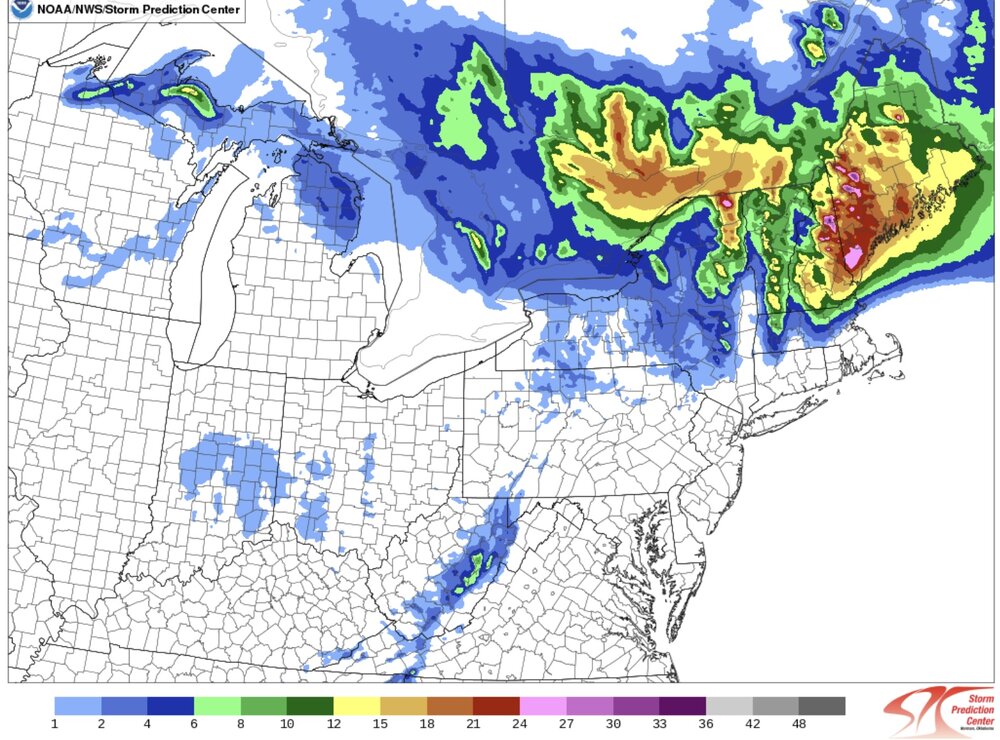
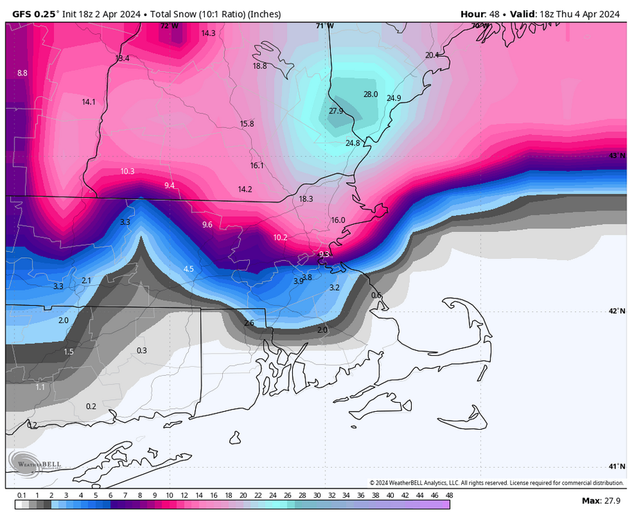
.png.e7f41ed8a502fde6b7e8f08c4ff688ff.png)
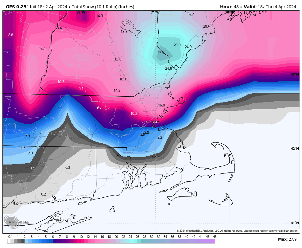
Significant Miller B Nor'easter watch, Apr 3rd-4th
in New England
Posted
QPF is always overdone when the mid level center is weakening and/or tracking west. I learned that in the early March 2009 system....clown maps kept trying to lay down like 18" and it ended up being like half of that.