

40/70 Benchmark
-
Posts
67,801 -
Joined
-
Last visited
Content Type
Profiles
Blogs
Forums
American Weather
Media Demo
Store
Gallery
Posts posted by 40/70 Benchmark
-
-
Zzzzzzzzzz
-
 1
1
-
 1
1
-
 1
1
-
-
17 minutes ago, ORH_wxman said:
Euro looks a bit warmer and north again. Almost game over for SNE but it does still hit ORH county to Berkshires decent.
Hoping for on more tick north so I can 86 the blogs.
-
2
-
-
Thank God for that huge block to stop the primary from getting through the lakes.
-
1
-
1
-
-
4 minutes ago, MJO812 said:
It's amazing even with the blocking. Usually we will have a weaker primary and a transfer further south but in these past winters.
It seems like every event we get a lecture about how it would have been through Montreal without it, but instead its 34 and rain. I think frankly I am all set with it.
-
1
-
-
49 minutes ago, ORH_wxman said:
Yep. Prob gonna check out on this one soon. I’ll give it another couple cycles though since there is still some spread south/colder. But this is starting to get the feeling of an NNE elevation storm and not the more cleanly phased tempest over the benchmark up to ACK.
Gonna need a shift south on subsequent cycles.
Amazing how the trend that we do not want is what always prevails these past few seasons. Just unreal.
-
3
-
-
15 minutes ago, 40/70 Benchmark said:
Gun to head right now.....4-8" of slop IMBY.
Not a bad guess...

-
Gun to head right now.....4-8" of slop IMBY.
-
1
-
-
I'm glad I have some latitude because how far north it gets when/if it gets captured will be huge.
-
1
-
-
That was the most explosive solution yet...only issue for SNE (of course) is it got captured just a hair too far NW.....I'm walking the line on that.
-
1
-
-
We have this thing doing a blizzard loop over se MA on Thursday PM now....get that over the islands, then we can talk HECS over SNE.
But as is...I see why the discrepancy over saying the Uk is inland....it must be doing what the EURO is....technically it is inland, but not because it's a hugger....it's doing a blizzard loop and getting captured.
-
2 minutes ago, Prismshine Productions said:
On the off chance low does capture and tug, how high does the weenie shoot up?
Sent from my SM-S146VL using Tapatalk
As high as the ceiling?
-
1
-
-
Looks like the trend tonight on the EURO and UK is to not allow it to escape and really capture/tug it back west....believe that when I see it. It's often modeled and seldom works out....even within 12 hours we see model fails on that.
-
1
-
-
1 minute ago, 40/70 Benchmark said:
Looks like some sort of cold drain from ME into my area....have to watch that, but this plays into why interior ne MA is a sneaky decent low terrain spot for Spring ordeals.
-
-
Wow...EURO is a doozy
-
GEPS coming in a bit less impressive...not really north, just a bit weaker.
-
1 minute ago, RUNNAWAYICEBERG said:
UK shifted south and colder.
Well, someone its wrong because this was 12z.

-
This may very well be mainly rain for all of SNE, but its not tracking inland.
-
Just now, 78Blizzard said:
Uncle says it is.
Uncle was in line with the GEM at 12z....tossed.
-
Just now, WinterWolf said:
Makes sense to me…but what do I know?
It makes sense if it's right.....if it's a hair to strong with the block, well.....
-
This isn't going into e MA.
-
1 minute ago, RUNNAWAYICEBERG said:
Gfs op way nw of every gefs members.
It was probable it was on crack, but its big to see a decent jump south by the GEFS.
-
4 minutes ago, Prismshine Productions said:
GEFS did tick south
Sent from my SM-S146VL using Tapatalk
Yea...solid move, too...looks like the 12z EPS.
-
1
-
-
1 minute ago, SnoSki14 said:
Not backing down. Do you think it has a clue?
For God's sake that thing even gives my region in Jersey 6-10" of tree crushing snows.
I'd like to see a shift south of the GEFS and EPS to consider it.
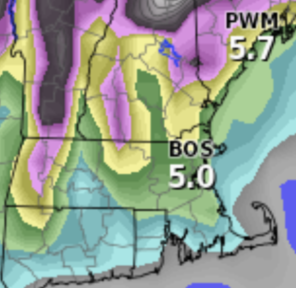

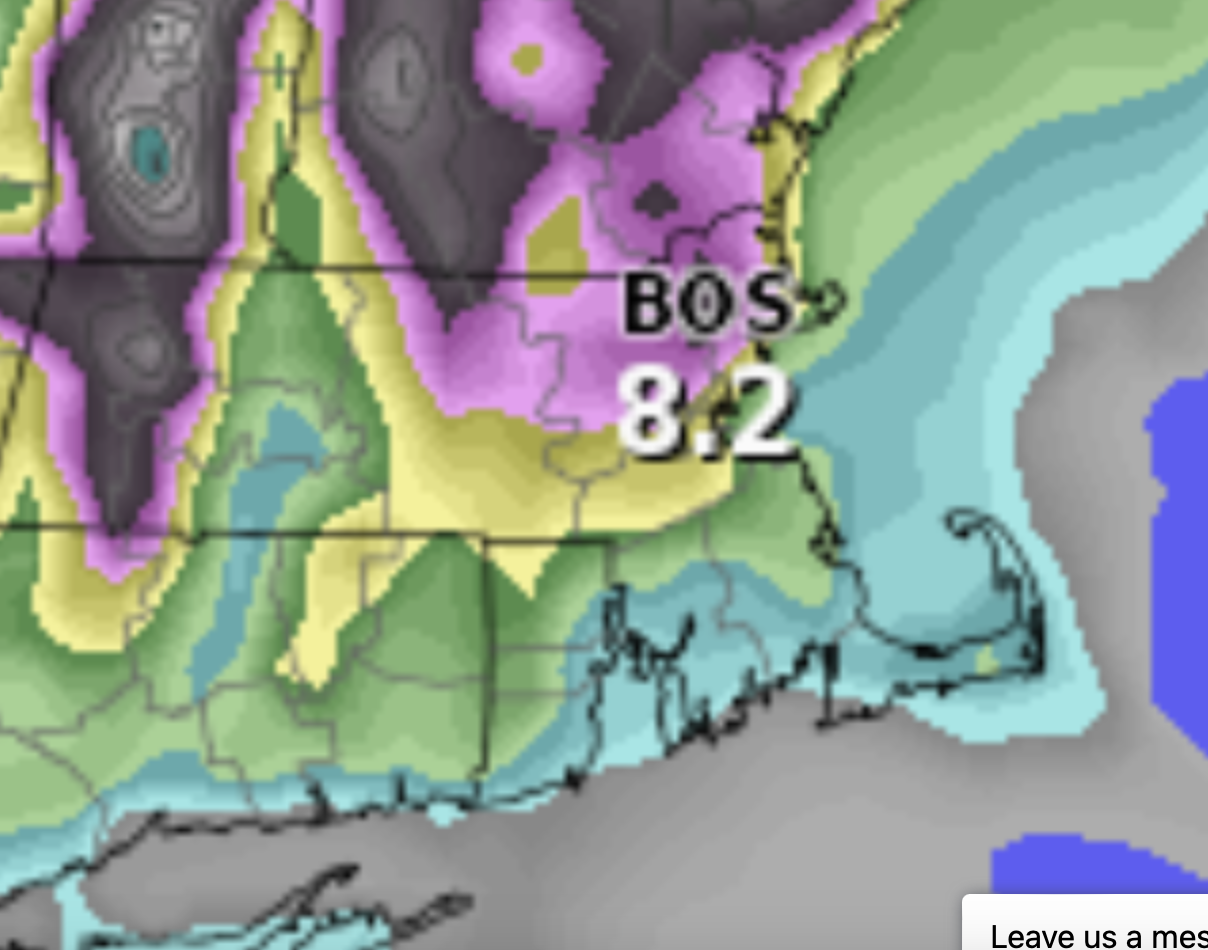
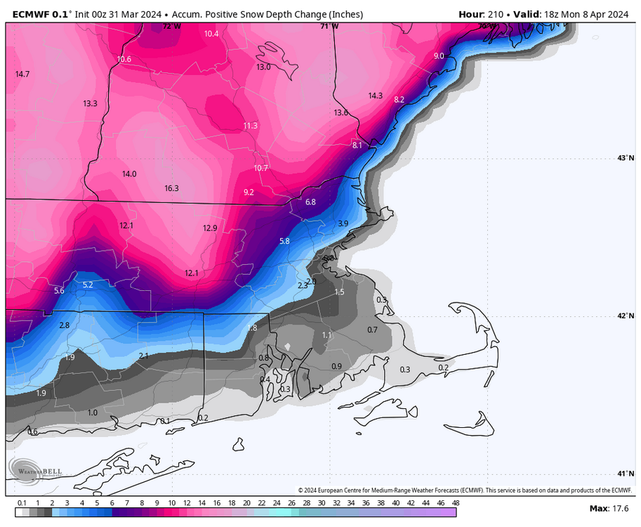
Significant Miller B Nor'easter watch, Apr 3rd-4th
in New England
Posted
Its gone. Nothing trends favorably.