

40/70 Benchmark
-
Posts
77,973 -
Joined
-
Last visited
Content Type
Profiles
Blogs
Forums
American Weather
Media Demo
Store
Gallery
Everything posted by 40/70 Benchmark
-

2025-2026 ENSO
40/70 Benchmark replied to 40/70 Benchmark's topic in Weather Forecasting and Discussion
The mean DM PNA value for the 4 seasons mentioned in raindance's post above is +.15, which affirms my suspicion of a variable PNA that averages near neutral this season. I don't see that huge negative values in the mean, and I think that notion that it has to be because it's a second year La Nina is every bit as dibious as that fallacy that all triple dip La Ninas have to be cold. Anticipate deeply negative PNA in the mean during the coming winter season at your own peril IMHO. -
2025-2026 ENSO
40/70 Benchmark replied to 40/70 Benchmark's topic in Weather Forecasting and Discussion
While that does look like a season that certainly won't be prohibitvely warm in the mean, that doesn't exactly scream KU snowstorms to me, either....still looks like more of an overrunning and SWFE pardigm to me. I think the window for any big fish will be later in the season. -
Down to 43.3 this AM....topped out at 70.7. Already back to 48.7
-
This also what I am alluding to when I tell folks to not obsess over the absolute PDO value, as it's the trend that is more important.
-
2025-2026 ENSO
40/70 Benchmark replied to 40/70 Benchmark's topic in Weather Forecasting and Discussion
This composite looks like a lot of my preliminary stuff. Extratropical Pacific, Polar and EMI composites.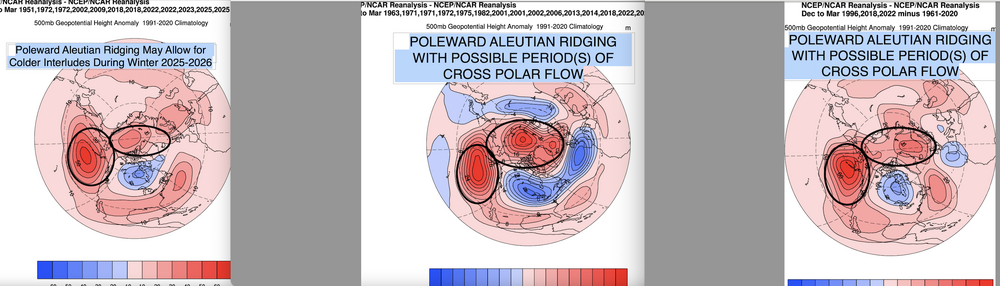
-
2025-2026 ENSO
40/70 Benchmark replied to 40/70 Benchmark's topic in Weather Forecasting and Discussion
Well, it is getting more difficult to get very cold winters in an absolute sense (against shifting climo is different)....that said, it's not as pronounced where you live as it is on the east coast. -
2025-2026 ENSO
40/70 Benchmark replied to 40/70 Benchmark's topic in Weather Forecasting and Discussion
@snowman19My guess is that while the majority of the season is -PNA, we are gong to have month that is gong to be strongly +PNA....probably coinciding with +NAO mid season before any SSW. Season probably averages pretty close to neautral with a slight hedge towards negative. -
2025-2026 ENSO
40/70 Benchmark replied to 40/70 Benchmark's topic in Weather Forecasting and Discussion
You mean +PNA? -
2025-2026 ENSO
40/70 Benchmark replied to 40/70 Benchmark's topic in Weather Forecasting and Discussion
Not sure winter averages +PNA per se, but it should be volatile. -
I think that will be dependent on the stratosphere.....seeing potential for a mid winter event, which would trigger a reload.
-
2025-2026 ENSO
40/70 Benchmark replied to 40/70 Benchmark's topic in Weather Forecasting and Discussion
I think you are obfuscating the PDO and WPO a bit. I think a severely +WPO does cap most of the mid atl and SNE at a near normal snowfall season....but I was referring to the PDO more in my response to you. There are plenty of severely negative PDO seasons that were very snowy in the east, but most of them are aged analogs due to the WPO, which has been biased very positive this decade by the warm pool. I don't think it needs to cool as much as you think to remain positve, but to a degree that isn't as prohibitive to wintry weather in the eastern US. -
2025-2026 ENSO
40/70 Benchmark replied to 40/70 Benchmark's topic in Weather Forecasting and Discussion
@snowman19You seem to pointing out why 2013 isn't a replica analog rather than why we can't see similar sensible weather adjusted for CC....as far as the former, I agree...no season really is; but I think the latter is entirely feasible. -
2025-2026 ENSO
40/70 Benchmark replied to 40/70 Benchmark's topic in Weather Forecasting and Discussion
I think if you want a big winter, the WPO is going to have be less severely positive than it has been....like 2017, for instance...which I believe may be the case. -
2025-2026 ENSO
40/70 Benchmark replied to 40/70 Benchmark's topic in Weather Forecasting and Discussion
First of all, I think the trend concerning the PDO is what is of most relevence with respect to sensible weather, not the absolute value. Secondly, the RONI is nearly dead-nuts on with 2013....and finally, I'm not sure the solar and statosphere differences are really that big of a deal. First of all, that was a very strongly +AO/NAO season, so that wasn't the main hemispheric driver, anyway. Additionally, I have written in great detail about how an easterly QBO near solar max isn't as hostile to episodes of high latitude blocking as some seem to think. We are probably going to see more arctic blocking than we did that year. Replica season? No....western Pacific is less favorable and CC has continued...but I see no reason why it can't be included in varuious seasonal composites, as it has been, and continues to be. -
2025-2026 ENSO
40/70 Benchmark replied to 40/70 Benchmark's topic in Weather Forecasting and Discussion
I can see in a practical sense, conversationally in an effort to convery how you feel the season will evolve, since most weather circles are privy with how each analog season behaved in terms of sensible weather. But as far as issuing a seasonal forecast, I agree 100%...my methodology is to use a composite and attempt to convey the element from each analog season that will be similar to the current season. This is important because one season may be a fantastic analog in one sense, but there are bound to be ways in which it is not..this harkens to what you were saying about the challenge in finding a replica season. Good luck- -
2025-2026 ENSO
40/70 Benchmark replied to 40/70 Benchmark's topic in Weather Forecasting and Discussion
Mirrors impact on winter storms. As a blogger, I like it....only care to write about big fish. -
Another .63" today....1.85" 2 day total, 1.96" 3 day.
-
2025-2026 ENSO
40/70 Benchmark replied to 40/70 Benchmark's topic in Weather Forecasting and Discussion
Yea, I'm not arguing any of that...but temps and 500mb heights are kind of a big deal. I mean, I nailed snowfall last season...but I was too warm....that can't be ignored. -
2025-2026 ENSO
40/70 Benchmark replied to 40/70 Benchmark's topic in Weather Forecasting and Discussion
Well, that is where we differ. I know in the past I have ostensibly nailed seasons, but always detract from the grade when I'm "right for the wrong reason". Agree to disagree. The forecast was wrong....it just so happen to be correct regarding low snowfall. -
1.22" today.
-
2025-2026 ENSO
40/70 Benchmark replied to 40/70 Benchmark's topic in Weather Forecasting and Discussion
It still got the pattern wrong, though...which is why it was too warm. I wouldn't consider it a win for those that forecasted a big winter for the mid atlantic during the 2015-2016 season, despite the fact that snowfall worked out. I'm not arguing your point about storm track, but the EURO seasonal was still a tremendously flawed forecast. I am willing to bet if we had less of a neg NAO last season, the northeast would have done better via more overrunning and SWFE snowfall, kind of like what we saw in February. I understand your point about increased reliance on Benchmark tracks in the NE, but some of that is due to SE Canada being warmer relative to other areas independent of CC. We saw that shift some last year and if se Canada is appreciably cold again, which I suspect that it will be, I would bet on more snowfall. -
2025-2026 ENSO
40/70 Benchmark replied to 40/70 Benchmark's topic in Weather Forecasting and Discussion
Did NOT get the pattern right, though.....suprised someone as meticulous as you would omit that. -
2025-2026 ENSO
40/70 Benchmark replied to 40/70 Benchmark's topic in Weather Forecasting and Discussion
Yes, this is what I have always said about climate models...they are biased towards stock ENSO. -
2025-2026 ENSO
40/70 Benchmark replied to 40/70 Benchmark's topic in Weather Forecasting and Discussion
I thought mine from last year was okay...not great, but not bad. -
That guy and DirectWeather are at the top of my $hit list for ignoring.


