donsutherland1
-
Posts
24,335 -
Joined
12 Followers








About donsutherland1

-
It's unfortunate. WB will never correct the algorithms.
-
I agree. It was good to see the sunshine.
-
Tomorrow and Wednesday will be variably cloudy days. A few locations could see a shower, but dry weather should be predominant. Highs should reach the lower and middle 60s. Some rain and showers are possible Thursday and Friday. The extent of the precipitation will depend on the track of a developing storm. For now, the system looks to pass far enough from the region to produce lighter to perhaps moderate amounts of precipitation. Uncertainty exists. Temperatures will remain unseasonably cool throughout the week with highs mainly in the lower and middle 60s. The ENSO Region 1+2 anomaly was +4.6°C and the Region 3.4 anomaly was +3.0°C for the week centered around September 16. For the past six weeks, the ENSO Region 1+2 anomaly has averaged +4.33°C and the ENSO Region 3.4 anomaly has averaged +2.73°C. Both ENSO regions have tied their all-time warmest anomalies. The ongoing strong El Niño, will continue to strengthen through the mid-fall. The SOI was -23.00 today. The preliminary Arctic Oscillation (AO) was +1.435 today. Based on sensitivity analysis applied to the latest guidance, there is an implied near 65% probability that New York City will have a cooler than normal September (1991-2020 normal). September will likely finish with a mean temperature near 68.5° (0.7° below normal). Supplemental Information: The projected mean would be 0.5° above the 1981-2010 normal monthly value.
-
It does appear that there is somewhat more dry air around than I had thought yesterday. So, today and even tomorrow could have some periods of sunshine with a diminished risk of showers. An offshore storm will need to be watched closely toward the end of the week.
-
Mid/late morning into early mid-afternoon may see some sun. Clouds should return afterward.
-
Periods of rain and drizzle are likely tomorrow and Tuesday. Highs tomorrow should be in the middle and upper 60s. Tuesday will be cooler with the temperature struggling to reach the lower 60s. Wednesday could temporarily dry out. Additional rain and showers are possible Thursday and Friday. Temperatures will remain unseasonably cool throughout the week with highs mainly in the lower 60s. The ENSO Region 1+2 anomaly was +4.5°C and the Region 3.4 anomaly was +2.9°C for the week centered around September 9. For the past six weeks, the ENSO Region 1+2 anomaly has averaged +4.23°C and the ENSO Region 3.4 anomaly has averaged +2.65°C. The ongoing strong El Niño, will continue to strengthen through the mid-fall. The SOI was -35.18 today. The preliminary Arctic Oscillation (AO) was +1.619 today. Based on sensitivity analysis applied to the latest guidance, there is an implied near 69% probability that New York City will have a cooler than normal September (1991-2020 normal). September will likely finish with a mean temperature near 68.3° (0.9° below normal). Supplemental Information: The projected mean would be 0.3° above the 1981-2010 normal monthly value.
-
Scenes from the New York Botanical Garden yesterday before a prolonged siege of clouds and periods of rain set in.

- 828 replies
-
- 10
-

-

-
A rainy period will likely develop tomorrow. Periods of rain could continue into at least the middle of next week. Temperatures will remain unseasonably cool throughout next week. The ENSO Region 1+2 anomaly was +4.5°C and the Region 3.4 anomaly was +2.9°C for the week centered around September 9. For the past six weeks, the ENSO Region 1+2 anomaly has averaged +4.23°C and the ENSO Region 3.4 anomaly has averaged +2.65°C. The ongoing strong El Niño, will continue to strengthen through the mid-fall. The SOI was -42.37 today. The preliminary Arctic Oscillation (AO) was +2.194 today. Based on sensitivity analysis applied to the latest guidance, there is an implied near 70% probability that New York City will have a cooler than normal September (1991-2020 normal). September will likely finish with a mean temperature near 68.2° (1.0° below normal). Supplemental Information: The projected mean would be 0.2° above the 1981-2010 normal monthly value.
-
Yes, in terms of the fall equinox, fall begins Tuesday. Meteorological fall, which is used for climate data purposes, began on September 1st.
-
It's early in terms of timing, but Sunday afternoon/evening appear to have the highest chance of heavier rain.
-
Cooler air will return for the weekend. Saturday will be a dry day with partly sunny skies. Clouds will increase on Sunday. Highs will be in the upper 60s to around 70°. A rainy period will likely develop late Sunday. Periods of rain could continue into at least the middle of next week. Temperatures will remain unseasonably cool throughout next week. The ENSO Region 1+2 anomaly was +4.5°C and the Region 3.4 anomaly was +2.9°C for the week centered around September 9. For the past six weeks, the ENSO Region 1+2 anomaly has averaged +4.23°C and the ENSO Region 3.4 anomaly has averaged +2.65°C. The ongoing strong El Niño, will continue to strengthen through the mid-fall. The SOI was -34.52 today. The preliminary Arctic Oscillation (AO) was +2.661 today. Based on sensitivity analysis applied to the latest guidance, there is an implied near 63% probability that New York City will have a cooler than normal September (1991-2020 normal). September will likely finish with a mean temperature near 68.5° (0.7° below normal). Supplemental Information: The projected mean would be 0.5° above the 1981-2010 normal monthly value.
-
Tomorrow will see temperatures top out in the upper 70s. Cooler air will return for the weekend. A rainy period could develop late Sunday and continue into early next week. Temperatures will remain unseasonably cool. The chance that the region could see its coolest air mass this fall arrive toward midweek next week has increased. The ENSO Region 1+2 anomaly was +4.5°C and the Region 3.4 anomaly was +2.9°C for the week centered around September 9. For the past six weeks, the ENSO Region 1+2 anomaly has averaged +4.23°C and the ENSO Region 3.4 anomaly has averaged +2.65°C. The ongoing strong El Niño, will continue to strengthen through the mid-fall. The SOI was -31.02 today. The preliminary Arctic Oscillation (AO) was +2.934 today. Based on sensitivity analysis applied to the latest guidance, there is an implied near 55% probability that New York City will have a cooler than normal September (1991-2020 normal). September will likely finish with a mean temperature near 69.0° (0.2° below normal). Supplemental Information: The projected mean would be 1.0° above the 1981-2010 normal monthly value.
-
Tomorrow through Friday will see temperatures recover mainly to the upper 70s. A few locations could reach or exceed 80° on one or more days. Cooler air will return for the weekend. A rainy period could develop late Sunday and continue into early next week. Temperatures will remain unseasonably cool. The ENSO Region 1+2 anomaly was +4.5°C and the Region 3.4 anomaly was +2.9°C for the week centered around September 9. For the past six weeks, the ENSO Region 1+2 anomaly has averaged +4.23°C and the ENSO Region 3.4 anomaly has averaged +2.65°C. The ongoing strong El Niño, will continue to strengthen through the mid-fall. The SOI was -36.78 today. The preliminary Arctic Oscillation (AO) was +2.191 today. Based on sensitivity analysis applied to the latest guidance, there is an implied near 54% probability that New York City will have a warmer than normal September (1991-2020 normal). September will likely finish with a mean temperature near 69.4° (0.2° above normal). Supplemental Information: The projected mean would be 1.4° above the 1981-2010 normal monthly value.
-
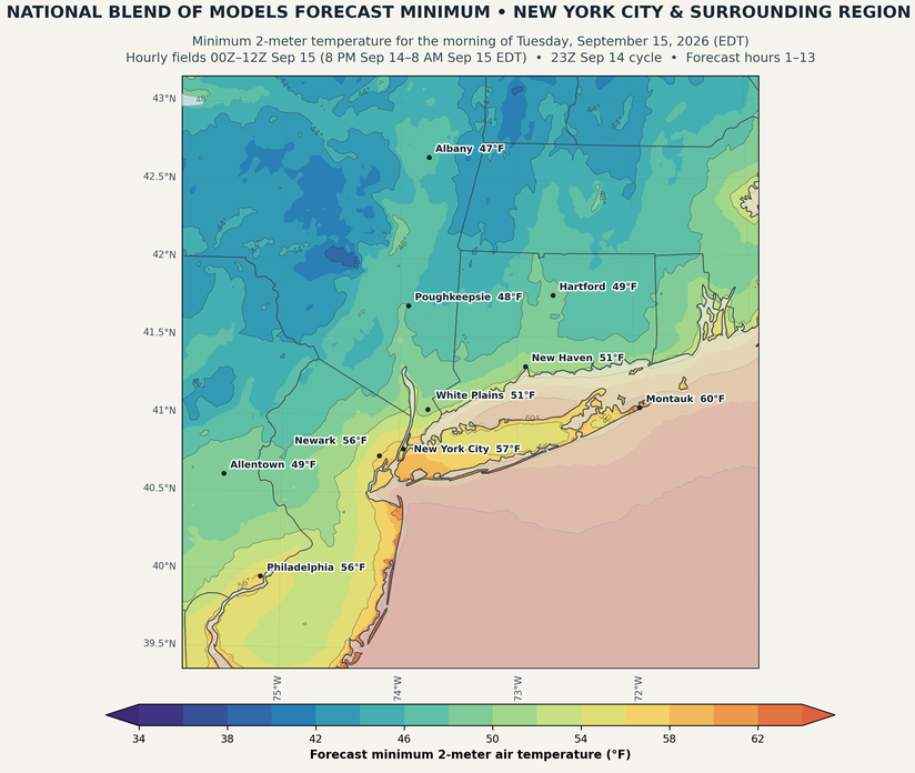
The New York City area will see its first lows in the 50s this season tomorrow morning.
-
The coolest air mass is continuing to push into the region. Highs tomorrow and Wednesday will reach the lower and middle 70s. New York City will see lows in the upper 50s to lower 60s. As a result, Central Park will experience its first reading below 60° this season tomorrow morning. the timing matches well with the last two El Niño events: 2015-2016: September 14 and 2023-2024: September 15. Wednesday through Friday will see temperatures recover mainly to the upper 70s. However, additional cool air will likely arrive some time during the next weekend. The ENSO Region 1+2 anomaly was +4.5°C and the Region 3.4 anomaly was +2.9°C for the week centered around September 9. For the past six weeks, the ENSO Region 1+2 anomaly has averaged +4.23°C and the ENSO Region 3.4 anomaly has averaged +2.65°C. The ongoing strong El Niño, will continue to strengthen through the mid-fall. The SOI was -25.91 today. The preliminary Arctic Oscillation (AO) was +1.373 today. Based on sensitivity analysis applied to the latest guidance, there is an implied near 54% probability that New York City will have a warmer than normal September (1991-2020 normal). September will likely finish with a mean temperature near 69.4° (0.2° above normal). Supplemental Information: The projected mean would be 1.4° above the 1981-2010 normal monthly value.