


wncsnow
-
Posts
8,890 -
Joined
-
Last visited
About wncsnow

- Birthday 09/05/1987
Recent Profile Visitors










-
CAD seems likely. I'm more interested in what may potentially develop in the Gulf or off the SE Coast. Euro and other models hinting at something. Potential heavy rains.
-
1.88 in the last 24 hours
-
Not ideal
-
Thanks for reminding me I didnt update it
-

2026-2027 Fall/Winter Mountain Thread
wncsnow replied to BlueRidgeFolklore's topic in Southeastern States
All Time Record daily high broken for Asheville- 92 -
Elevation matters in marginal cold
-
With this super el Nino we should probably expect the unexpected. Just need cold and subtropical jet to meet up one time and we could be looking at Jan 2016 or December 2009 redux
-
Looks like my posts about extreme heat have aged well after all
-
We got heavy rain last night around midnight adding up to .76.
-
A true southern belle who truly cared about those who struggled and did so much for them unlike our corrupt government
-
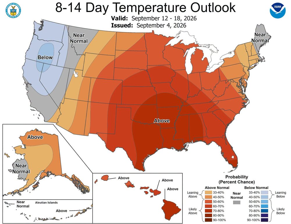
We are talking about the pattern. Isn't the name of this thread mid-long range discussion? The mid to long range looks well above normal.
-
You sure? Looks like plenty of mid to upper 90s for most piedmont and some 100's.
.thumb.png.33cf7788bb94492cd8d7af7c973a343e.png)
-
Early September heat is on. Huge ridge of high pressure.
-
It can really pour along the escarpment late evening in August when there is a slight NE flow
-
After last night's deluge, we've had 5 inches of rain the past 72 hours.





.png.4730f459e3414234449d11bbf2ee12b2.png)