All Activity
- Past hour
-

Strong Nor'Easter/Hybrid Storm Late September 2026
wthrmn654 replied to Rjay's topic in New York City Metro
No change from Upton , already passed there usual time when they change/ issue things -

2026 Atlantic Hurricane Season
vortex95 replied to Stormchaserchuck1's topic in Tropical Headquarters
I forgot to check the 1000-500 thickness. Good catch! 576+ is more than enough for a solid warm color that is not shallow (500 and below). The initial low pressure center currently is S of the 576 thk line, and it wrap up and pools this value into a discrete closed contour! That's what Sandy had offshore E of ORF the day of landfall. -

Strong Nor'Easter/Hybrid Storm Late September 2026
jm1220 replied to Rjay's topic in New York City Metro
Big time beach erosion and flood risk with a track like that. -
 best pharmacy in india: GenIndusPharma - buy generic medicines online india
 -

October Comes Early: Late September Multi-Hazard Hybrid Storm
jbenedet replied to WxWatcher007's topic in New England
I have long been a critic of the NHC on topics like this. Way behind the ball. I think they need to reconsider their mission statement. NHC tracking fish storms in the middle of the Atlantic….some 2000+miles away from any civilization. Meanwhile 10+ million Americans exposed to a modeled tropical type storm inside 48 hours and they haven’t even flagged it. -
online canadian pharmacy or best online canadian pharmacy canadian pharmacy drugs online https://cse.google.be/url?sa=t&url=https://canamcrosscare.shop canadian pharmacies that deliver to the usor https://mantiseye.com/community/nnsjedxxzx top canadian pharmacy [url=http://www.google.bt/url?q=https://canamcrosscare.shop]canada pharmacy online[/url] canadian pharmacy ltdor [url=https://www.0468wudi.com/home.php?mod=space&uid=292457]canadian drug pharmacy[/url] canadian drug pharmacy
-
https://geninduspharma.com/# order medicine online in india
-
2026 Atlantic Hurricane Season
vortex95 replied to Stormchaserchuck1's topic in Tropical Headquarters
The 00z ECMWF track now gives the E Coast storm a sig better chances for going ST or even T w/ it farther S initially. The warm core is very apparent. 20 C at 925, 12 C at 700, and -5 C at 500 when it it close to 39.7N / 71.8W. Those are Sandy profile numbers from recon when it warm secluded and formed a small inner core the day of landfall (looked a lot like the Perfect Storm 1991 hurricane) after looking less tropical from when it was in the Bahamas to this point. And as a result, TS development probs has increased significantly to as high as 80% (60% on previous run). And yet nothing from NHC on its TWO.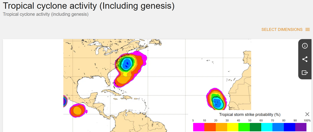
-

Strong Nor'Easter/Hybrid Storm Late September 2026
Neblizzard replied to Rjay's topic in New York City Metro
If the 0z EURO is right , that’s exactly what will happen. -
October Comes Early: Late September Multi-Hazard Hybrid Storm
vortex95 replied to WxWatcher007's topic in New England
The 00z ECMWF track now gives it a sig better chances for going ST or even T w/ it farther S initially. The warm core is very apparent. 20 C at 925, 12 C at 700, and -5 C at 500 when it it close to 39.7N / 71.8W. Those are Sandy profile numbers from recon when it warm secluded and formed a small inner core the day of landfall (looked a lot like the Perfect Storm 1991 hurricane) after looking less tropical from when it was in the Bahamas to this point. And as a result, TS development probs has increased significantly to as high as 80% (60% on previous run). And yet nothing from NHC on its TWO.
-

Strong Nor'Easter/Hybrid Storm Late September 2026
MJO812 replied to Rjay's topic in New York City Metro
Yep stronger run. Gfs also caved. -

October Comes Early: Late September Multi-Hazard Hybrid Storm
DirtySnowDen replied to WxWatcher007's topic in New England
This is “The Perfect Storm”…..all major models show the eye developing at the 250mb level. Also, considering the tilted nature of its development, it will be a busy day later today. You have a strong tropical Burp crashing into a strong high that splits. With the full moon, this has distaster written all over it for CT, RI and southeastern MA. I’m hungry and I hope I get to eat my words. -
Strong Nor'Easter/Hybrid Storm Late September 2026
Neblizzard replied to Rjay's topic in New York City Metro
0z Euro slams into NJ, widespread 2 inches of rain and strong winds for NYC/LI/NJ -
canadian pharmacy rx or online pharmacy canada canadian pharmacy official site http://www.livebar.de/url?q=https://canamcrosscare.com canadian pharmacy world or https://kamayegaindia.com/user/tpbbxskffj/?um_action=edit п»їcanadian pharmacy [url=https://images.google.bs/url?q=https://canamcrosscare.com]reputable canadian pharmacy[/url] canadian drug pharmacy and [url=http://sotoycasal.com/user/bysphyonce/]п»їcanadian pharmacy[/url] п»їcanadian pharmacy
-

October Comes Early: Late September Multi-Hazard Hybrid Storm
SnoSki14 replied to WxWatcher007's topic in New England
That's a very subtropical storm structure -
October Comes Early: Late September Multi-Hazard Hybrid Storm
vortex95 replied to WxWatcher007's topic in New England
I can't recall, neither such a strong high and (non-tropical) low pressure in September in these areas. This would be impressive for mid-winter! - Today
-

October Comes Early: Late September Multi-Hazard Hybrid Storm
WxWatcher007 replied to WxWatcher007's topic in New England
Robust but south. Gotta imagine the Euro and GFS meet in the middle as they usually do. -

October Comes Early: Late September Multi-Hazard Hybrid Storm
CoastalWx replied to WxWatcher007's topic in New England
Euro trying for nj again. Lol -
October Comes Early: Late September Multi-Hazard Hybrid Storm
CoastalWx replied to WxWatcher007's topic in New England
Dude trust me. Scotty knows -
 Unnamed Subtropical Storm 1968 85mph 979mb
 -

October Comes Early: Late September Multi-Hazard Hybrid Storm
Cyclone-68 replied to WxWatcher007's topic in New England
Probably a dumb question but what was the strongest sub tropical storm to ever happen in the Atlantic? -
mexipharmacy website: SolMeds Direct - mexican pharmacy online medications
-
mexipharmacy website: SolMeds Direct - mexican pharmacy online medications
-
October Comes Early: Late September Multi-Hazard Hybrid Storm
WxWatcher007 replied to WxWatcher007's topic in New England
Maybe it’s getting a clue, but there’s still a ways to go before we have our well formed low. At the moment it’s still a highly strung out weak low attached to a frontal boundary. -
Wonder if Polo being Polo is downstream pumping to cause a bit more atmospheric friction?... It was not forecasted to get as strong as it did Sent from my SM-S176V using Tapatalk