All Activity
- Past hour
-
Rain is here. Pouring out there this morning. Drought is over.
-

2026-2027 Super El Nino
so_whats_happening replied to Stormchaserchuck1's topic in Weather Forecasting and Discussion
Im good thanks though. Carry on with your reading. -
 http://sildoliko.com/# viagra canada
 -

2026-2027 Super El Nino
TriPol replied to Stormchaserchuck1's topic in Weather Forecasting and Discussion
I'm trying to read about a historic El Nino. That's all I care about. I just want to read it in peace and not read posts about a meteorologist calling out other people who are not meteorologists because of something they did. I think that's what we all want, yes? So you delete your post attacking snowman19 and I'll delete my posts as well and we can all go back to tracking a once in a lifetime weather event. -
2026-2027 Super El Nino
so_whats_happening replied to Stormchaserchuck1's topic in Weather Forecasting and Discussion
No one forced you to respond either yet somehow you felt it was important. -
2026-2027 Super El Nino
TriPol replied to Stormchaserchuck1's topic in Weather Forecasting and Discussion
There are other weather forums. No one is forcing you to be here. -
2026-2027 Super El Nino
so_whats_happening replied to Stormchaserchuck1's topic in Weather Forecasting and Discussion
We are on page 127 of this thread and it is August nearly 50% of these pages are filled with crap. -
2026-2027 Super El Nino
TriPol replied to Stormchaserchuck1's topic in Weather Forecasting and Discussion
Can we get back to El Nino and not call people out online? -
2026-2027 Super El Nino
so_whats_happening replied to Stormchaserchuck1's topic in Weather Forecasting and Discussion
You need to relax man twitter has you all up in a bind over nothing. You rage out on every poster who questions you. Fix those issues man. -

2026-2027 Super El Nino
snowman19 replied to Stormchaserchuck1's topic in Weather Forecasting and Discussion
What the fuck are you talking about? I don’t give a shit if you’re a red rag or not don’t you dare accuse me plagiarism. Show me what I plagiarized, let’s see it -
Buy Tadalafil 10mg Tadaliko - buy cialis pill
- Today
-
Cialis 20mg price in USA Tadaliko - Buy Tadalafil 5mg
-
Cialis over the counter Tadaliko - Tadaliko
-
 Global models has been showing a very active monsoon trough in the NWPAC w/ as many as 5 TCs at once. 5 named storms in this basin has happened many times. 6 only once on 8/15/2018. You get large monsoonal depressions and small spin-up gyres that are not always declared by JTWC. GFS for Monday shows 5 distinct systems of various intensity and size.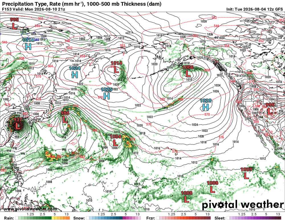
-
https://sildoliko.com/# Viagra Tablet price
-
 Spiral galaxy mode engaged.
 -
2026-2027 Super El Nino
so_whats_happening replied to Stormchaserchuck1's topic in Weather Forecasting and Discussion
You really need to start tagging other peoples work and not trying to show it off as your own even if it is from twitter. -
2026-2027 Super El Nino
so_whats_happening replied to Stormchaserchuck1's topic in Weather Forecasting and Discussion
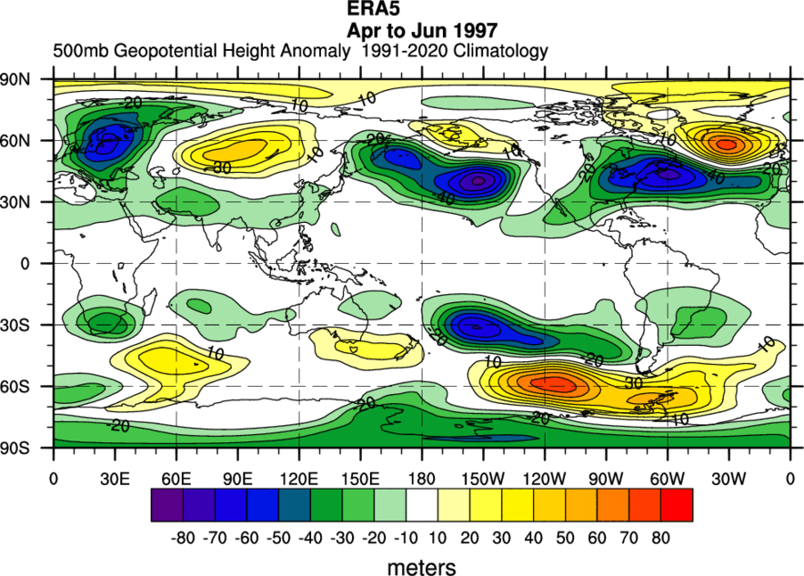
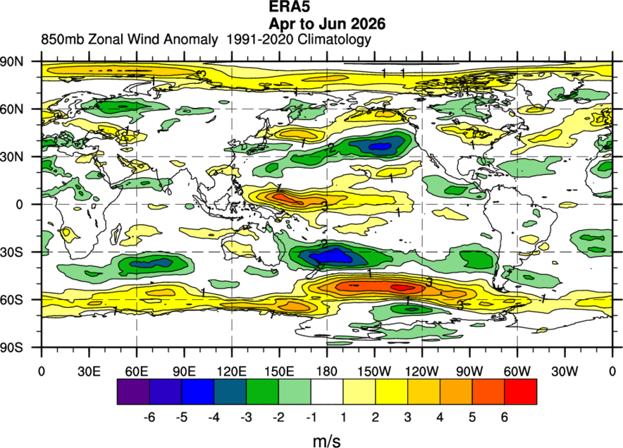
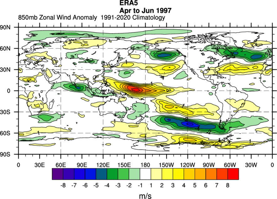
"The bi-monthly Multivariate El Niño/Southern Oscillation (ENSO) index (MEI.v2) is the time series of the leading combined Empirical Orthogonal Function (EOF) of five different variables (sea level pressure (SLP), sea surface temperature (SST), zonal and meridional components of the surface wind, and outgoing longwave radiation (OLR)) over the tropical Pacific basin (30°S-30°N and 100°E-70°W). The EOFs are calculated for 12 overlapping bi-monthly "seasons" (Dec-Jan, Jan-Feb, Feb-Mar,..., Nov-Dec) in order to take into account ENSO's seasonality, and reduce effects of higher frequency intraseasonal variability. During the typical height of ENSO during late Fall/early Winter, the canonical features of atmosphere and ocean anomalies are shown schematically below based on a composite of 11 historical El Niño and La Niña events. Key features of composite positive MEI events (warm, El Niño) include (1) anomalously warm SSTs across the east-central equatorial Pacific, (2) anomalously high SLP over Indonesia and the western tropical Pacific and low SLP over the eastern tropical Pacific, (3) reduction or reversal of tropical Pacific easterly winds (trade winds), (4) suppressed tropical convection (positive OLR) over Indonesia and Western Pacific and enhanced convection (negative OLR) over the central Pacific (Fig. 1a). Key features of composite negative MEI events (cold, La Niña, Fig. 1b) are of mostly opposite phase. For any single El Niño or La Niña situation, the atmospheric articulations may depart from this canonical view." https://psl.noaa.gov/enso/mei/ What would this second combined EOF do exactly to help with this metric? A 'V' component to wind is important just not as functional in the sloshing of waters as the 'U' wind tends to be. Wind and SLP go hand in hand so they should carry the same weight. OLR is covered over a very large area of the equatorial Pacific it literally is measuring the intensity/location of forcing within the atmosphere. WWBs being further east and west is also important into the evolution of an ENSO (El Nino) event. I completely disagree that OHC should be added, SSTs do just fine. We already have RONI which is just stating the obvious of what is happening in a warming world with warming oceans. The only criticism I would have of MEI is it plays catch up in all events but it often signals when the state has changed properly. We have been also noticing more lately that each block tropics/subtropics, mid latitudes, and polar regions have not been cohesive with each other. So while the tropics may be humming along in an El Nino the mid latitudes can react very differently and can be destructive to the evolution of ENSO in either state. Just as much as the northern hemisphere and southern hemisphere will experience ENSO events differently. This El Nino has been awfully more impactful within the southern hemisphere than so far in the northern hemisphere. This could change but have yet to see those signs show up in the 500mb pattern. Unfortunately this has not updated for July so I can't do a longer comparison but over the time period of greatest warming and exertion of a changing ENSO state these are the 500mb maps and wind anomalies we have seen between these two events. We seem to be running out of resources for plotting data so we are left with what we can find. Just because we are having something producing similar numbers in SST anomalies does not mean things will follow the exact same way as a previous event did. Overall this just tells me in the near 30 years that ocean temps have become dramatically warmer globally, to a rather drastic extent. The implications of such we do not fully understand yet or how it will affect these events as we go through time.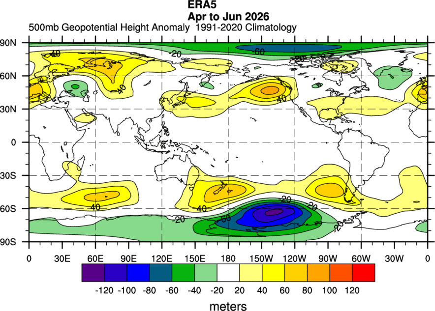
-
Buy Tadalafil 5mg Buy Tadalafil 20mg - Tadaliko
-
Canada Storm-Specific SVR/TOR Warnings
vortex95 replied to vortex95's topic in Weather Forecasting and Discussion
Was delayed, now goes into effect 8/11/26. https://dd.meteo.gc.ca/doc/genots/2026/08/03/NOCN04_CWAO_031225___62572 -
One of the best weather days of the season. Going to have to wait awhile for another one as we will be back in the Sauna starting later Wednesday - with heat advisories likely and severe and flooding watches warnings to go along with it.
-
Order Viagra 50 mg online Buy generic 100mg Viagra online - buy viagra here
-
cialis generic - [url=https://tadaliko.shop/#]Tadaliko[/url] Tadaliko
-
2026-2027 Super El Nino
snowman19 replied to Stormchaserchuck1's topic in Weather Forecasting and Discussion
I get what you’re saying with adding an OHC component to the formula, but I think looking at it separately is just as effective -
2026-2027 Super El Nino
snowman19 replied to Stormchaserchuck1's topic in Weather Forecasting and Discussion
And the MEI cope has officially failed miserably, down in flames!! Womp, womp!! The last 5 months have been absolutely hilarious. Let’s see…First there was the RONI cope, FAIL, then there was the SOI cope, FAIL, then there was the trade winds are going to come back cope, FAIL, then there was the ridiculous Modoki cope, FAIL, then there MEI cope, FAIL, now we have the -PDO cope, also destined to miserably fail this fall. Can’t wait to see what the next copium will be to downplay the strongest east-based super El Niño in history…. Have to post this again….makes me smile