All Activity
- Past hour
-
which one would stand out if 100 was the criteria, 1993?
-
Then there would have only been one event that qualified as per Don's chart. 100 is too high for our area.
-
1977 and 1993 really stand out in this list
-
 I think someone hits 105
 -
why did they pick such a weird number-- 97? 100 should be the number.
-
Will we get an old fashioned heat wave with 90+ temps that lasts at least 5 days?
-
I believe JFK had a maximum-minimum thermometer, so the high should be accurate even if it occurred between hours.
-

Mountain West Discussion
mayjawintastawm replied to mayjawintastawm's topic in Central/Western States
I'll take it over the sauna that we currently have. 98/42 at 5 PM MT IMBY. 98/20 at Buckley AFB nearby...6% RH will dry you out in a hurry. -
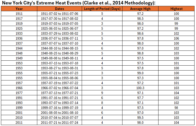
Despite the expected extreme heat, it is possible that New York City's Central Park will fall short of the criteria needed to qualify as an extreme heat event (Clarke et al., 2014 Methodology). To get there, there would need to be at least 3 97° highs, every high during the period would need to be 90° or above, and the average high during the period would need to be 97° or above. Below is a list of such events:
-
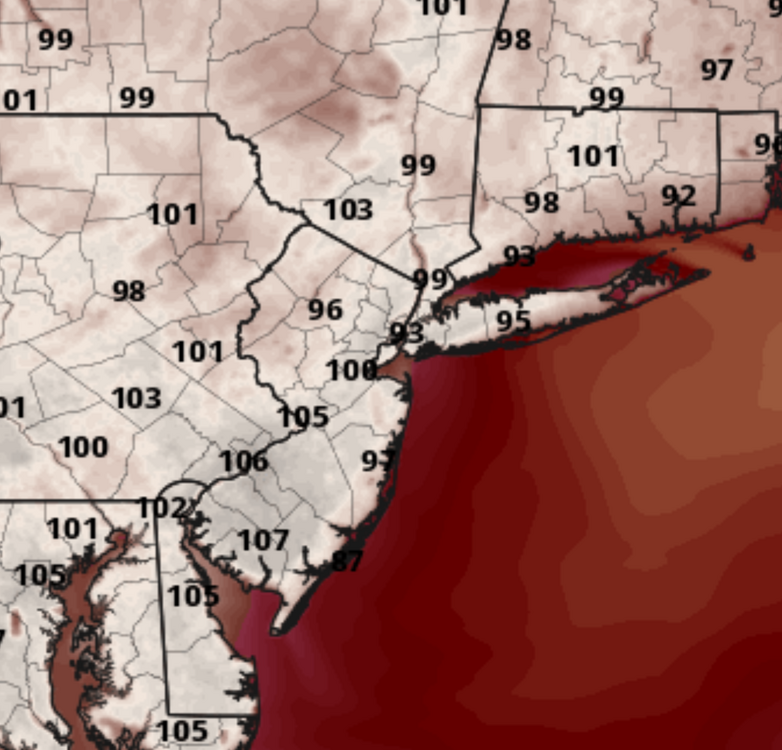
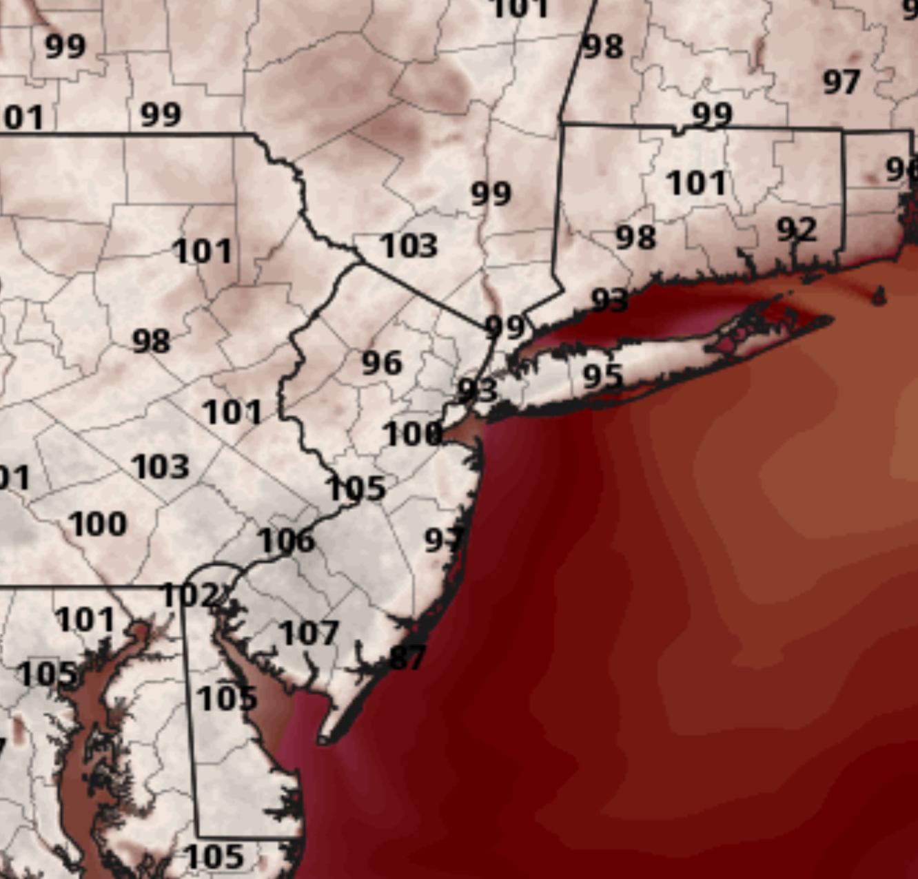
The always overheated GEMLAM has high heat for us Tuesday but the highest is actually in southern NJ. This is 2PM Tuesday:
-
This sounds so easy to do that it makes me think there's a reason they don't do it. Maybe they're counting on the canopy to hide the equipment from vandals. I don't know why they don't surround it with a barbed wire electrified fence.
-
Was that the winter where JFK got two 6 inch events within 10 days of each other? and NYC's largest event was 4 inches lol
-
Just cut back the canopy that towers around the station.
-
Perhaps that equipment should be moved downtown. Park temperatures are not what New York City residents typically experience.
-
The wind really picked up out there
-
On June 26, 1952 as I showed previously, JFK reached 99 on a SSW wind and when the wind switched to WSW it was at 99 for two more hours. It's possible 100 was reached in between hours on that day there but not recorded. I think it shows that JFK can reach 100 there in June even on an onshore wind in June.
-
On the nose...
-
Always exciting to see how these heat waves will end.
-
I imagine we'll see a few days of very high cape with unbreakable Inversions in the week ahead.
-
My guess is s SPC put that In place just incase anything does managed to break the cap in the afternoon.
-
Yeah I couldn't believe how low the dew points were. Hardly worked up a sweat. Got a jump on Monday and Tuesday. Sawed up a few big 'ol Black locusts.
-
 While ewr gets to at least 104 Edit i just saw your guesses above
 -
Also, the low of 80F at Eau Claire, Wisconsin was 1F shy of both the June monthly record high minimum and the all-time record high minimum. La Crosse, Wisconsin was 1F shy of the monthly & 2F below the all-time record. Possibility that one or both gets set or tied tonight/tomorrow if the winds stay up enough. Also would need to stand through midnight local time. Not sure if there’s a risk of convection there tomorrow.
-
It was very close on previous outlooks. as mentioned yesterday spc keeps the chances alive but slim untill Monday.


.thumb.jpg.6a4895b2a43f87359e4e7d04a6fa0d14.jpg)

