All Activity
- Past hour
-
6z RGEM slight shift west as well..NE TN folks may end up with a little something after all
-

First Legit Storm Potential of the Season Upon Us
MJO812 replied to 40/70 Benchmark's topic in New England
.thumb.png.da263e76a9e850f72967da5fee62c8a9.png)
-
First Legit Storm Potential of the Season Upon Us
MJO812 replied to 40/70 Benchmark's topic in New England
Rgem more amped.thumb.png.90c994fddd1c169b1ef2ce41804415e9.png)
-
3k NAM is either out to lunch or at least trying to bring snow showers/flurries along the TN/NC border counties late this evening/tonight.
-

2025-2026 ENSO
donsutherland1 replied to 40/70 Benchmark's topic in Weather Forecasting and Discussion
They should do better this time. -

First Legit Storm Potential of the Season Upon Us
dendrite replied to 40/70 Benchmark's topic in New England
We’re going to be in trouble when NCEP drops all of the models for just the rrfs. -
If there is even snow in the air.
-
Storm potential January 17th-18th
donsutherland1 replied to WeatherGeek2025's topic in New York City Metro
With the temperature now up to 36 in Central Park, only a trace of snow is the most likely outcome today. A coating is a lower probability. -
Roofus
.thumb.png.e42cc7e865d4c8081e0e4da1a68cae6e.png)
-
First Legit Storm Potential of the Season Upon Us
MJO812 replied to 40/70 Benchmark's topic in New England
Roofus.thumb.png.531a5b2badd04012717655b80049f241.png)
-
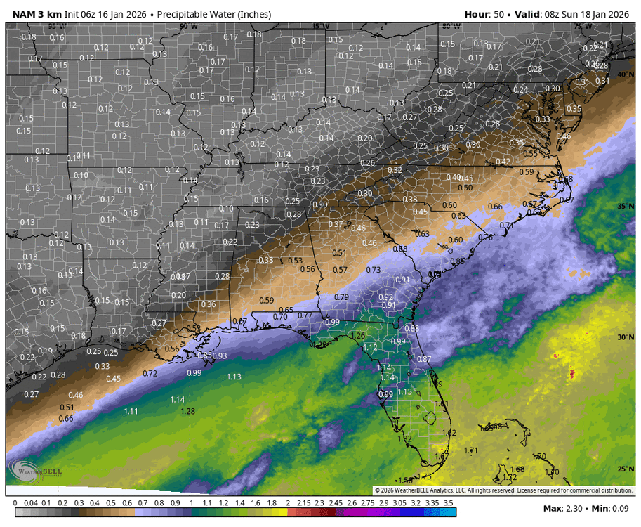
Trend is clear as day on the NAM. The angle of moisture fetch off the gulf has improved dramatically. I think the NW portion of that precip shield is likely under-modeled as well. Between the terrain and the sloped arctic front aiding in lift, it won’t take a ton of moisture to squeeze something out further north and west. Still too early to feel confident in it, but who woulda thought this time last night that we’d still be in the game? Precipitable water values trend on NAM 3km.
-
3k Nam is also much further north and west
.thumb.png.620aeb568460e69f00366d8c23c0defd.png)
-
First Legit Storm Potential of the Season Upon Us
MJO812 replied to 40/70 Benchmark's topic in New England
3k Nam is also much further north and west. Nice for Cape..thumb.png.47e30c5ca03182fd6b6b96a4c7de877d.png)
-

First Legit Storm Potential of the Season Upon Us
ineedsnow replied to 40/70 Benchmark's topic in New England
YES!.thumb.png.94851b5ef46895e242c19b0acf2b81aa.png)
-
Nam !
.thumb.png.4dd17a92ee47fbe7fdf8ca584fbbd6fe.png)
-

First Legit Storm Potential of the Season Upon Us
ORH_wxman replied to 40/70 Benchmark's topic in New England
The vort didn’t quite curl like 00z but everything started west so the end result was pretty similar to 00z…it was heftier south of here. Maybe a bit better on south shore as well. -
First Legit Storm Potential of the Season Upon Us
MJO812 replied to 40/70 Benchmark's topic in New England
Wow.thumb.png.70d8c6fdb2bbaf729cd8fe34200c3bb4.png)
-
First Legit Storm Potential of the Season Upon Us
ineedsnow replied to 40/70 Benchmark's topic in New England
Chased convection at the last minute.. if that wasn't there it would have been a big hit -
6z roofus also
.thumb.png.9a2d2d0883f6b77876416cc67b981116.png)
-
First Legit Storm Potential of the Season Upon Us
MJO812 replied to 40/70 Benchmark's topic in New England
Roofus.thumb.png.c0c4ba3a6d9c244423e215a986f59ec1.png)
-
First Legit Storm Potential of the Season Upon Us
ineedsnow replied to 40/70 Benchmark's topic in New England
Much better and probably not done trending -
First Legit Storm Potential of the Season Upon Us
MJO812 replied to 40/70 Benchmark's topic in New England
Nam cranking up there.thumb.png.b75e4a6703c6475d429de57c770d8670.png)
-
NAM way west oh my goodness, lol
-
First Legit Storm Potential of the Season Upon Us
MJO812 replied to 40/70 Benchmark's topic in New England
Nam so far.thumb.png.0275ee720426af778f1ccf4ba0113300.png)
-
First Legit Storm Potential of the Season Upon Us
ineedsnow replied to 40/70 Benchmark's topic in New England
NAM is going to be a good hit

.png.37db6e16382300dca1cca1fc945c5e3e.png)
.png.76dba6aa23499571d48481d21d42f170.png)

.png.da3fef3321bccf40dc636b85ff4ac608.png)
.png.beadcdf6e5405b2f9a2ff81647e7e1b8.png)


.png.26fbe76c775dc987cc029e05c56f94ea.png)
.png.cd7fc858bb53c01bc37f2317a9348d64.png)
.png.b1f7d78412c82522a0c87a610bbec201.png)
.png.076cf75bffd080f09eee740b01b13c8c.png)
.png.e44b37f8795c99f249287c8fea52ad8e.png)

.png.6873b9edc55bd69f583f65b464583d28.png)
.png.1445cb832657b134c0a595469e15e204.png)
.png.6b6319a0249205e627643d7f60e0c22b.png)

.png.592df3244778fcf86974eb09d9c76578.png)