All Activity
- Past hour
-
Was talking in general not imby lol
-
06Z RGEM Kuchera snow vs. 00Z totals. Still rather conservative (surface thermals) and mainly late afternoon into Sunday night. Areas in between the monster bands near the Atlantic Coast and the inverted trough band west could very well get sub-warning criteria snow given the weaker rates.

.thumb.png.1cc2bc28b461d8ae609e0deadf2d6abd.png)
-

“Cory’s in NYC! Let’s HECS!” Feb. 22-24 Disco
The 4 Seasons replied to TheSnowman's topic in New England
we're gonna get whacked -
I was gonna say 8-12 but that works too .
-
Rgem is snowier than 0z
.thumb.png.0aa9b53f7318b1f2e48c208241ffc847.png)
-
I think a good starting point is 6-12.
-
Don't get carried away. The euro shows much less, particularly in western areas.
-

“Cory’s in NYC! Let’s HECS!” Feb. 22-24 Disco
Roger Smith replied to TheSnowman's topic in New England
So 6" for the thread starter? (jk) That map looks very plausible to me, will see if 06z GFS changes my opinion. -
Get the euro on board.
-

“Cory’s in NYC! Let’s HECS!” Feb. 22-24 Disco
40/70 Benchmark replied to TheSnowman's topic in New England
"Therrreees the Demon"...I definitely invoked Bruce's spirit last night. -
Whats scary is that might be conservative. Good start.
-
“Cory’s in NYC! Let’s HECS!” Feb. 22-24 Disco
The 4 Seasons replied to TheSnowman's topic in New England
"East facing slopes of the Worcester Hills...30...35...possibly 40 inches!" -
Upton all in
-
“Cory’s in NYC! Let’s HECS!” Feb. 22-24 Disco
40/70 Benchmark replied to TheSnowman's topic in New England
https://easternmassweather.blogspot.com/2026/02/severe-winter-storm-imminent-sunday.html First Call: -
“Cory’s in NYC! Let’s HECS!” Feb. 22-24 Disco
40/70 Benchmark replied to TheSnowman's topic in New England
LBSW is now just about LBLI -
3k NAM has low getting down to 965... that's incredible for a non-tropical low... Sent from my motorola edge 2024 using Tapatalk
-
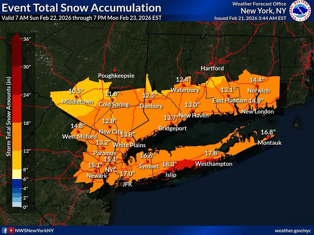
Winter storm warning for 10-16” in my backyard, can’t wait to see the map in the morning URGENT - WINTER WEATHER MESSAGE National Weather Service Mount Holly NJ 327 AM EST Sat Feb 21 2026 PAZ070-071-101>106-212100- /O.UPG.KPHI.WS.A.0002.260222T1100Z-260223T2300Z/ /O.NEW.KPHI.WS.W.0002.260222T1200Z-260223T2300Z/ Delaware-Philadelphia-Western Chester-Eastern Chester-Western Montgomery-Eastern Montgomery-Upper Bucks-Lower Bucks- Including the cities of Doylestown, Morrisville, Kennett Square, Pottstown, West Chester, Oxford, Norristown, Media, Philadelphia, Collegeville, Chalfont, Perkasie, Lansdale, and Honey Brook 327 AM EST Sat Feb 21 2026 ...WINTER STORM WARNING IN EFFECT FROM 7 AM SUNDAY TO 6 PM EST MONDAY... * WHAT...Heavy snow expected. Total snow accumulations between 10 and 16 inches. Winds gusting as high as 40 mph. * WHERE...A portion of southeast Pennsylvania. * WHEN...From 7 AM Sunday to 6 PM EST Monday. * IMPACTS...Travel could be very difficult to impossible. Areas of blowing snow could significantly reduce visibility. The hazardous conditions could impact the Monday morning and evening commutes. * ADDITIONAL DETAILS...Snowfall rates could exceed 2 inches per hour. Locally higher snowfall amounts possible. Blowing and drifting of snow, and whiteout conditions possible. PRECAUTIONARY/PREPAREDNESS ACTIONS... If you must travel, keep an extra flashlight, food, and water in your vehicle in case of an emergency. The latest road conditions for the state you are calling from can be obtained by calling 5 1 1. && $$
-
-
“Cory’s in NYC! Let’s HECS!” Feb. 22-24 Disco
40/70 Benchmark replied to TheSnowman's topic in New England
3k is 965 just inside the BM. That works. -
Less snow on this run but still really good. Low is also east.
.thumb.png.baca819984f7baf24437555efc9ac449.png)
-
I just said it too. It had to be done.
-
“Cory’s in NYC! Let’s HECS!” Feb. 22-24 Disco
Roger Smith replied to TheSnowman's topic in New England
What page might I find your map forecast for this event? I am holding off speculating until I see 06z GFS. -
I concur, I believe they will in the interest of public safety. Upton knows wassup.
-
“Cory’s in NYC! Let’s HECS!” Feb. 22-24 Disco
The 4 Seasons replied to TheSnowman's topic in New England
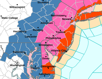
Since blizz warnings are up I'll definitely be labeling this one with the B word. Will go down as the Blizzard of 26 since Jan didn't steal the title with relatively lighter winds -
They have, blizzard warnings extend to DE


.png.6fb82aa08accc295c2d267069ecdf2f8.png)


.png.e69562e69ee6fa7124b27575dd6c6cdc.png)


.png.09f27112a3438b8f2e4cf833ecf8b41c.png)
