All Activity
- Past hour
-

October Comes Early: Late September Multi-Hazard Hybrid Storm
WxWatcher007 replied to WxWatcher007's topic in New England
Robust but south. Gotta imagine the Euro and GFS meet in the middle as they usually do. -

October Comes Early: Late September Multi-Hazard Hybrid Storm
CoastalWx replied to WxWatcher007's topic in New England
Euro trying for nj again. Lol -
October Comes Early: Late September Multi-Hazard Hybrid Storm
CoastalWx replied to WxWatcher007's topic in New England
Dude trust me. Scotty knows -
 Unnamed Subtropical Storm 1968 85mph 979mb
 -

October Comes Early: Late September Multi-Hazard Hybrid Storm
Cyclone-68 replied to WxWatcher007's topic in New England
Probably a dumb question but what was the strongest sub tropical storm to ever happen in the Atlantic? -
 mexipharmacy website: SolMeds Direct - mexican pharmacy online medications
 - Today
-
mexipharmacy website: SolMeds Direct - mexican pharmacy online medications
-
October Comes Early: Late September Multi-Hazard Hybrid Storm
WxWatcher007 replied to WxWatcher007's topic in New England
Maybe it’s getting a clue, but there’s still a ways to go before we have our well formed low. At the moment it’s still a highly strung out weak low attached to a frontal boundary. -
Wonder if Polo being Polo is downstream pumping to cause a bit more atmospheric friction?... It was not forecasted to get as strong as it did Sent from my SM-S176V using Tapatalk
-
mexican pharmacy that ships to usa: SolMeds Direct - mexican online pharmacies
-

Strong Nor'Easter/Hybrid Storm Late September 2026
TriPol replied to Rjay's topic in New York City Metro
If you don't care, why post? There are people who care. It'll fascinating watching the Titans at MetLife Stadium during a huge wind and rain storm on Sunday afternoon. -

Strong Nor'Easter/Hybrid Storm Late September 2026
GaWx replied to Rjay's topic in New York City Metro
0Z UKMET goes NNE to eastern end of LI and then into SE New England while weakening substantially Mon-Tue -

Strong Nor'Easter/Hybrid Storm Late September 2026
Prue11 replied to Rjay's topic in New York City Metro
Does anyone actually care if this storm hits us or not? For me could care less moderate winds rain we don’t need and coastal flooding is always dangerous -
pharmacy in mexico online: buy from mexico pharmacy - mexican rx
-

Strong Nor'Easter/Hybrid Storm Late September 2026
wthrmn654 replied to Rjay's topic in New York City Metro
Nam doesn't look to bad either. Put it in the books. Tracks much better concrnsus tonight -
Strong Nor'Easter/Hybrid Storm Late September 2026
wthrmn654 replied to Rjay's topic in New York City Metro
Throw in the cmc trying to play with the others but it's too shy and stays out by the cape. -
Strong Nor'Easter/Hybrid Storm Late September 2026
wthrmn654 replied to Rjay's topic in New York City Metro
Yep icon gfs and euro are all identical with exact placement only thing to figure out but they all stall, go west then loop then do something. -
Strong Nor'Easter/Hybrid Storm Late September 2026
wthrmn654 replied to Rjay's topic in New York City Metro
Icon nearly stalls out dropping pressure south of montauk point till ally 12 Sunday then starts crawling west ish -
Strong Nor'Easter/Hybrid Storm Late September 2026
wthrmn654 replied to Rjay's topic in New York City Metro
Crazy to think the nws is/ was going with a east storm even as the trend was clear as day since 6z today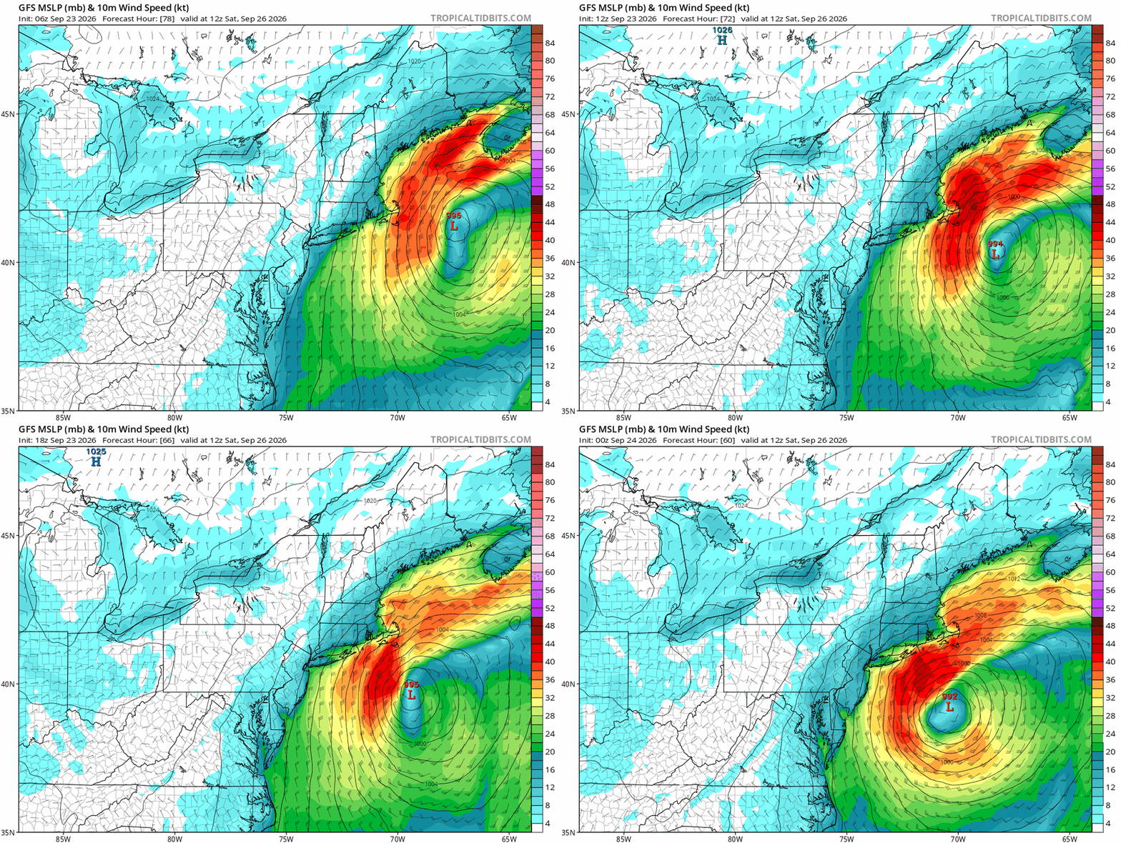
-
Nice soaking rain at times today afterall. Finished with .31 here
-

October Comes Early: Late September Multi-Hazard Hybrid Storm
DirtySnowDen replied to WxWatcher007's topic in New England
I’d like this thing to go OTS, but considering the time frame, I’m expecting something of a “landfall” in RI, the high pressure to the north is going to be the determining factor and how it splits. Another smaller, yet important factor, is going to be how strong the Low deepens upon their “dance.” -

October Comes Early: Late September Multi-Hazard Hybrid Storm
WinterWolf replied to WxWatcher007's topic in New England
Picking up on the stronger high pressure…? And we are getting closer in now, maybe it’s getting a clue? And yes…that 1041 high is very impressive, have we ever/how often have we seen that in September while a system will be climbing the coast? -

2026 Atlantic Hurricane Season
vortex95 replied to Stormchaserchuck1's topic in Tropical Headquarters
These are non-trivial probabilities for TC formation of the E Coast, and yet nothing in the TWO? Let me put it this way, you can't highlight areas w/ 0/0 chance on the tropical wx outlook (they do do this) and ignore something like this. And beyond the the model probs, from a empirical fcst skill/experience, such a formation is quite possible. So objective end subjective combined, that's how to do it!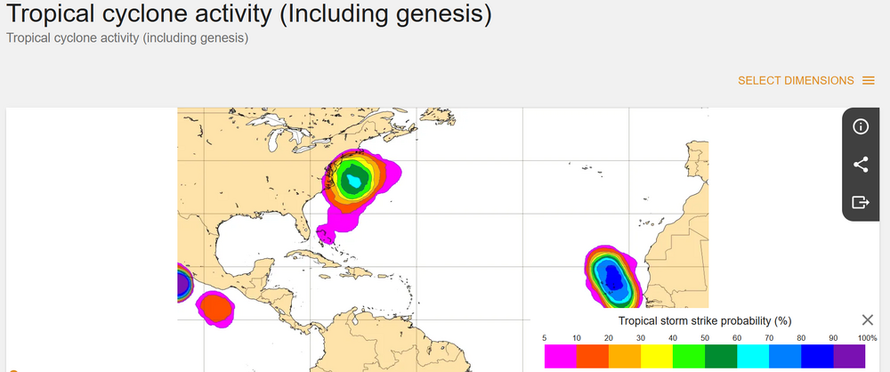
-
October Comes Early: Late September Multi-Hazard Hybrid Storm
DirtySnowDen replied to WxWatcher007's topic in New England
The uncertainty is what’s has my “brain-a-tickin’ -
October Comes Early: Late September Multi-Hazard Hybrid Storm
vortex95 replied to WxWatcher007's topic in New England
Those TC probs are *non-trivial*. Certainly enough to say something in the TWO, so you see what I mean. This is not a far-fetched situation from a model probability standpoint, and lots of decision go/no go as from model probs. As I like to say, you can't have it both ways here! Highlight systems w/ 0/0 percent chance and then ignore something like this? And beyond the the model probs, from a empirical fcst skill/experience, such a formation is quite possible. So objective end subjective combined, that's how to do it!