All Activity
- Past hour
-

July 2025 Discussion-OBS - seasonable summer variability
LibertyBell replied to wdrag's topic in New York City Metro
I just saw a live video of the Manhattan skyline, why does it look so POLLUTED and SMOGGY?? Barely any visibility in the video I saw, meanwhile 25 miles to the east over here it's a very clear and deep blue sky with zero haze. -
I've never played Sky Meadow so have no idea what I am walking in to.
-
Ens guidance continues the idea of h5 ridge building out west for early August. For now it looks like we see below avg temps the first few days of the month then probably moderating to around avg. Could be some storms in the Aug 5-7 period if the GFS has the right idea, with some energy digging southward as the western ridge amplifies.
-
July 2025 Discussion-OBS - seasonable summer variability
LibertyBell replied to wdrag's topic in New York City Metro
are there power outages or something? what causes the intrahour issues? I think they missed a 90 degree reading in there, we hit 90 here a few days ago at 4:04 pm and JFK didn't catch it. -

July 2025 Discussion-OBS - seasonable summer variability
SACRUS replied to wdrag's topic in New York City Metro
Max temps for Jul (so far) all on 7/8 EWR: 100 LGA: 98 JFK: 93 NYC: 93 -
July 2025 Discussion-OBS - seasonable summer variability
SACRUS replied to wdrag's topic in New York City Metro
I hope the JFK reporting includes the intra hour readings today, would be ashame to miss some spikes between hours. Still dealing with BLM issues for over 2 months. -
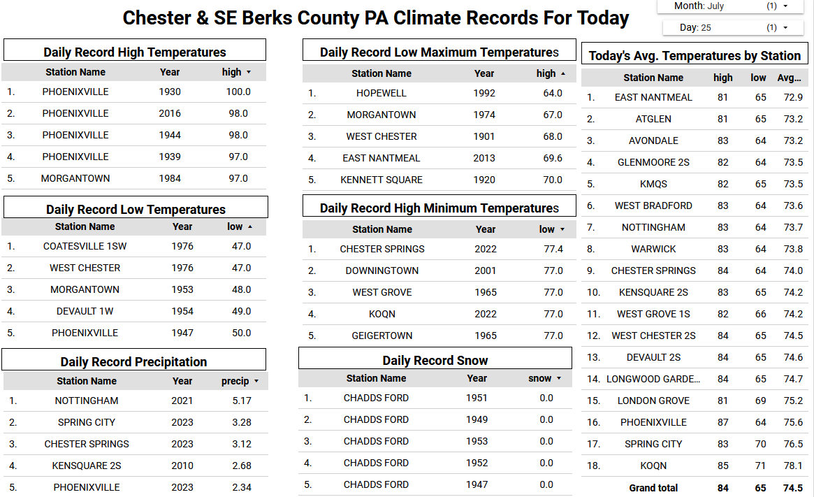
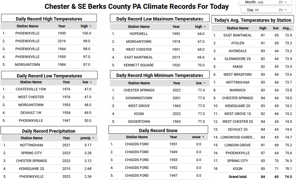
 Avondale 2012 average temp = 54.4 / 2023 = 54.4 / 2024 = 54.6 - scary warming trend there!!
 -
July 2025 Discussion-OBS - seasonable summer variability
LibertyBell replied to wdrag's topic in New York City Metro
94-98 is the range I would go with and that's pretty good (and close to our July max of 95 which we hit earlier in the month.) -

July 2025 Discussion-OBS - seasonable summer variability
winterwarlock replied to wdrag's topic in New York City Metro
I think upper 90s in the hottest spots with full sun. Yesterday wasnt all that hot but I ended up surging late to 90...I dont think its as intense as the June scorch but would be surprised not to hit at least 94 today. -
July 2025 Discussion-OBS - seasonable summer variability
LibertyBell replied to wdrag's topic in New York City Metro
The only thing that interrupted that heatwave was a 3.25 inch deluge on Day 3, I wonder what kind of storm that was? That was almost a 15 day heatwave if you count the 89 the day before it started. -
July 2025 Discussion-OBS - seasonable summer variability
LibertyBell replied to wdrag's topic in New York City Metro
wow it shows that even low to mid 90s can be deadly, the length of that heatwave might be what made it so deadly. It's not on the list of longest NYC heatwaves though. Why was that heatwave in 1972 more deadly than the two longer and more extreme heatwaves in 1999 though? 1999 was second only to 1953 in heatwave length and extremes. -
July 2025 Discussion-OBS - seasonable summer variability
SACRUS replied to wdrag's topic in New York City Metro
In an otherwise cooler summer in reference to the deadly 1972 heatwave - it di feature an almost 2 week heat wave. Nothing exceptional but apparently this was a deadly heatwave in the mid atlantic / northeast EWR July 1972 Newark Weather Day High (°F) Low (°F) Precip. (inches) Snow (inches) July 1 84 64 0.00 0.0 July 2 91 71 0.00 0.0 July 3 91 72 0.14 0.0 July 4 79 65 0.00 0.0 July 5 68 61 0.10 0.0 July 6 75 59 0.00 0.0 July 7 78 60 0.00 0.0 July 8 78 63 0.13 0.0 July 9 79 61 0.00 0.0 July 10 89 67 0.00 0.0 July 11 91 69 0.00 0.0 July 12 91 73 0.00 0.0 July 13 78 71 3.25 0.0 July 14 92 73 0.00 0.0 July 15 95 76 0.00 0.0 July 16 90 77 0.00 0.0 July 17 92 75 0.74 0.0 July 18 90 78 0.00 0.0 July 19 95 78 0.00 0.0 July 20 90 74 0.11 0.0 July 21 93 73 0.19 0.0 July 22 92 75 0.00 0.0 July 23 96 79 0.00 0.0 July 24 90 80 0.00 0.0 July 25 91 72 0.01 0.0 July 26 80 66 0.00 0.0 July 27 81 68 0.00 0.0 July 28 81 68 0.00 0.0 July 29 81 66 0.00 0.0 July 30 81 69 0.00 0.0 July 31 73 69 0.03 0.0 -
July 2025 Discussion-OBS - seasonable summer variability
LibertyBell replied to wdrag's topic in New York City Metro
Oh nice I am going with this classification too. Hot is like a SECS (4-8 inches of snow) Strong heat is like a MECS (8 to 15 inches of snow) Extreme heat is like a HECS (16 to 29 inches of snow) Inferno is like a BECS (30 inches of snow plus) I would adjust strong heat to 95-99 and extreme heat to 100-104 though -
Or is it UHI at the Airport? 1940's vs today of the problem that is our PHL Heat Island.
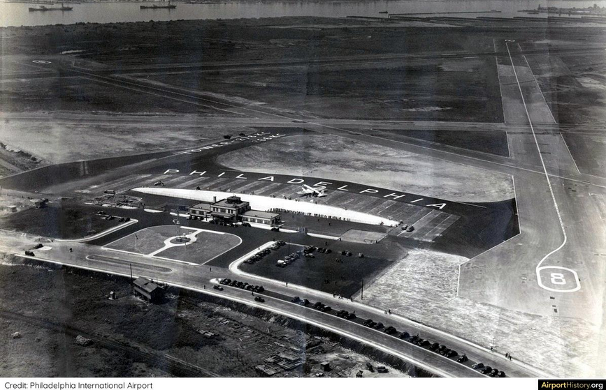
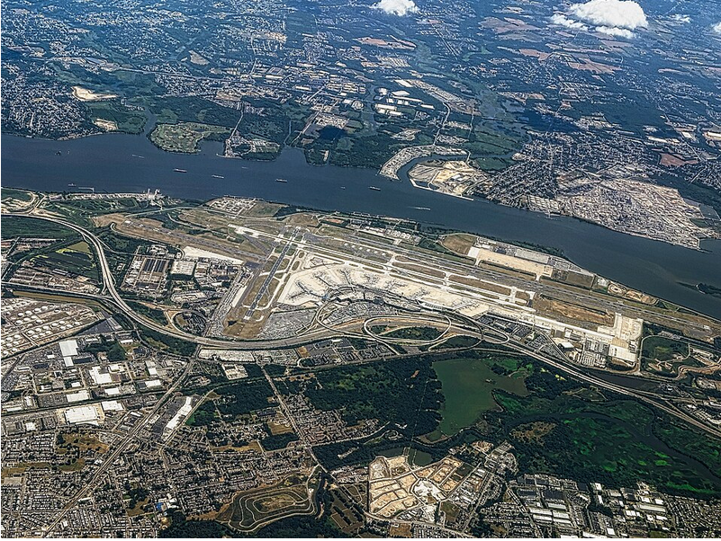
-
July 2025 Discussion-OBS - seasonable summer variability
SACRUS replied to wdrag's topic in New York City Metro
0.16 -
July 2025 Discussion-OBS - seasonable summer variability
SACRUS replied to wdrag's topic in New York City Metro
Assuming hot is : 90 - 94 Strong heat : 95 - 98 Extreme heat : 99 - 104 Inferno : 105+ Id go in the strong heat category with a few hot spots at extreme heat. 850 MB temps 18C - 19C. -
July 2025 Discussion-OBS - seasonable summer variability
LibertyBell replied to wdrag's topic in New York City Metro
Yes, around here it's only been 5 days, we got about 30 minutes of a very heavy rain shower on the night of 7/20.... do you have the JFK total from that night Tony? -
July 2025 Discussion-OBS - seasonable summer variability
LibertyBell replied to wdrag's topic in New York City Metro
are we sure today's going to be all that hot? it's not even in the mid 80s here yet and the sky is a deep blue kind of clear sky, no haze like we usually see on very hot days and the temperatures are not rising quickly like they did in late June at this time. -
July 2025 Discussion-OBS - seasonable summer variability
SACRUS replied to wdrag's topic in New York City Metro
Im going on 10 days since last rainfall here Last rainfall for the following EWR: 7/14 NYC: 7/14 LGA: 7/14 JFK: 7/20 -
Beginning to wonder if the term 'heat wave' is the right nomenclature for that western Pac thermal anomaly. Heat wave implies a beginning, and then an end. There is no "wave" if whatever is occurring does not ascend and then descend, or vice versa. This thing? ascended gradually over the last 10 years and has been transfixed - if perhaps wobbling around .. Perhaps it the waved nature extends over multi-decade. Then we'd have to get into the philosophy of whether time range disqualifies a wave phenomenon and ugh... Anyway, it's not behaving like a wave. In fact, it smacks like a 30 years from now ...the mean will be adjusted up because of it's presence, and the "anomaly" will disappear in the arithmetic means once the moving climate calcs are reapplied. It's just the new order, in other words. Not saying that's the case ... but it's not acting like a "wave" nonetheless. As an after thought, it seems as GW's gone up, this thing's emerged almost in lock step with the last 20 years of the GW acceleration. Gets easier to assume there's a connection there but just supposition for now I guess.
-
July 2025 Discussion-OBS - seasonable summer variability
LibertyBell replied to wdrag's topic in New York City Metro
Wild, the endless heat of 1936, 1999 and 2010 continued ..... 2010: The 105 °F recorded at the Richmond International Airport on the 24th and 25th also ties the highest maximum temperature ever recorded in July in Richmond. The high of 105 °F and low of 79 °F on these two dates yields a daily average temp of 92.0 °F which breaks the all-time daily mean temp of 91.5. Thus making these two dates the hottest days ever recorded in the past 113 years for Richmond. (Ref. Richmond Weather Records - KRIC) This highest temperature ever recorded for July of 105 °F has occurred on two other dates. (Ref. Richmond Weather Records - KRIC)On the 25th, damaging straight line thunderstorm winds with widespread gusts 60-75 mph and isolated gusts to 90 mph across parts of Fairfax and Loudoun Counties in Virginia and Montgomery, northern Prince Georges, Ann Arundel and Charles counties in Maryland and in Washington, DC. The storm resulted in 3 deaths from wind and one from lightning, widespread damage from downed trees and power lines, and loss of power to more than 300,000 customers. Highs: EWR: 99 (2016) one of only 2 days in Jul with record highs not 100 or higher NYC: 97 (1999) LGA: 97 (1999) JFK: 93 (2010) New Brunswck: 98 (2010) -
July 2025 Discussion-OBS - seasonable summer variability
LibertyBell replied to wdrag's topic in New York City Metro
Yeah we really don't get the kind of droughts here that they get in California and other places out west. I don't think we can go more than 6-7 days without rain here in the summer anymore. We might get a lot of rain at once, which isn't good either. -
The heat and humidity return today with many spots near or above 90 degrees. We cool down a notch over the weekend but with increasing shower chances by Saturday night into Sunday morning. Hot again early next week before a big cool down arrives by later next week.
-
July 2025 Discussion-OBS - seasonable summer variability
SACRUS replied to wdrag's topic in New York City Metro
Records: Highs: EWR: 99 (2016) one of only 2 days in Jul with record highs not 100 or higher NYC: 97 (1999) LGA: 97 (1999) JFK: 93 (2010) New Brunswck: 98 (2010) Lows: EWR: 57 (1932) NYC: 57 (1953) LGA: 59 (1997) JFK: 59 (1997) New Brunswick: 52 (2003) Historical: 1609: The Jamestown expedition nearly came to an untimely end as the fleet of ships encountered a tropical storm while sailing northwest through the Bahamas. One of the nine ships sunk and the rest of the fleet scattered as far north as Bermuda. (Ref. Wilson Wx. History) 1891 - The mercury hit 109 degrees at Los Angeles, CA, marking the peak of a torrid heat wave. (David Ludlum) 1936: Lincoln, Nebraska saw an all-time high temperature of 115 degrees. The low only dropped to 91 degrees and the average temperature was 103. Many people spent the night sleeping outside to escape the heat. 1952: The State of Alabama was in the midst of a critical heat wave and drought. During an 8-day stretch, the "coolest" high temperature in Birmingham was 99°. The heat peaked on this date in Birmingham at 106°. This was just one degree short of the highest temperature ever recorded at Birmingham on 7/29/1930. During that heat wave and drought, some wells in Alabama went dry for the very first time. (Ref. Wilson Wx. History) 1956 - The Andrea Doria sank in dense fog near Nantucket Lightship, MA. The ship was rammed by the Swedish-American liner, Stockholm, forty-five miles off the coast of Massachusetts. Fifty-two persons drowned, or were killed by the impact. (David Ludlum) (The Weather Channel) 1959: The depression meandered westward while steadily intensifying, becoming a Tropical Storm Debra on July 24. A turn towards the northwest became evident as it attained Category 1 hurricane status on the Saffir–Simpson Hurricane Scale on the following day. Strength was maintained as the hurricane curved northward at a slow forward speed, and it approached the coast of Texas as a minimal hurricane. Debra made landfall between Freeport and Galveston, Texas early on July 25. Debra rapidly weakened into a tropical storm and later a depression as it moved inland, and it dissipated on July 28. The remnant moisture later sparked upper-level thunderstorms in late July and early August.[2] Torrential rains were produced in southeastern Texas, peaking at 15.89 inches in Orange. This led to widespread flooding on highways, including portions of Farm Road 518, Highway 6, Highway 146, and U.S. Route 75. Sea vessels took the brunt of the storm, with many becoming stranded or damaged. Air, rail, and road transportation were significantly interrupted or even shut down. High winds from the storm caused expansive damage to buildings, windows, signs, and roofs. The hurricane resulted in 11 injuries but no human deaths, although approximately 90 cattle drowned. Damage in Brazoria, Galveston, and Harris counties surmounted $6.685 million. Additionally, impact in other areas increased the total losses to $7 million. (Ref. Wikipedia) (Ref. Daily News Record Newspaper - Harrisonburg, Virginia) 1972: Killing heat from 13th to 25th resulted in 185 deaths in Baltimore and 85 in the rest of MD. This heat wave in New York and Northeastern United States was significant as almost 900 people perished; the heat conditions lasted almost 16 days. (1972 Heat Wave - Wikipedia.org) 1974: Brownsville, Minn.--Lightning killed a 17-year-old youth as he slept in a tent. A companion was injured. Western Texas--Lightning struck and fatally injured a woman during a thunderstorm. (Ref. Lightning-The Underrated Killer.pdf) 1979: Flooding continues from Tropical Storm Claudette produced phenomenal rainfall totals in southeast Texas. 43 inches fell in 24 hours around Alvin; setting a U.S. record. Freeport reported a total of 30 inches. Total damage from flooding was over $400 million dollars. (Ref. Wilson Wx. History) 1984: The hardest hit area was the state capital of Pierre of SD. Winds gusting to 83 mph demolished 13 planes and several hangers at the Pierre airport. The thunderstorm also produced very heavy rains as 4 inches of rain fell in 30 minutes flooding streets across town. Winds in excess of 70 mph caused crop and property damage in many areas across central South Dakota. (Ref. Wilson Wx. History) 1986 - Tremendous hailstones pounded parts of South Dakota damaging crops, buildings and vehicles. Hail piled two feet deep at Black Hawk and northern Rapid City. Hail an inch and a quarter in diameter fell for 85 minutes near Miller and Huron, piling up to depths of two feet. (The Weather Channel) 1987 - Sixteen cities in the eastern U.S. reported record high temperatures for the date. Beckley, WV, equalled their all-time record high of 91 degrees, established just the previous day. It marked their fourth day in a row of 90 degree heat, after hitting 90 degrees just twice in the previous 25 years of records. The water temperature of Lake Erie at Buffalo, NY, reached 79 degrees, the warmest reading in 52 years of records. (The National Weather Summary) 1988 - Thunderstorms produced severe weather from central Kansas to western Kentucky and southern Illinois during the day. Thunderstorms produced tennis ball size hail at Union, MO, and winds gusts to 65 mph at Sedalia, MO. Five cities in Washington and Oregon reported record high temperatures for the date. Medford, OR, hit 107 degrees. (The National Weather Summary) (Storm Data) 1989 - Early afternoon thunderstorms over west central Missouri drenched the town of Ferguson with four inches of rain. Early evening thunderstorms in Pennsylvania produced more than two inches of rain north of Avella in one hour. (The National Weather Summary) 1990: Intense, slow-moving thunderstorms, dumped up to 11 inches of rain in just 6 hours at Lawton, OK. The flash flooding closed many roads, and 50 to 60 motorists had to be rescued when they became stranded in the high water. (Ref. Wilson Wx. History) 1992: Grapefruit sized hail knocked windshields out of several cars about 9.5 miles northeast of Scott City, KS.(Ref. Wilson Wx. History) 1993: Lightning prevalent in north and eastern GA - 12 homes hit in Cobb County (2 destroyed). A police officer in Augusta survived a strike while working a traffic accident. On the 26th, 10 people at the Atlanta Zoo were injured by lightning while sheltering under a gazebo. (Weather Guide Calendar with Phenomenal Weather Events 2011 Accord Pub. 2010, USA) 1997: Campbell County, VA a lightning strike injured a man at Timberlake. (Ref. Lightning - Virginia Weather History) 1998: Kansas City was especially hard hit by heavy rain with the suburb of Independence reporting 6.5 inches of rain, most of it falling in a matter of a few hours. Thunderstorms produced 2 to 3 inches of rain over parts of Banner and Cheyenne counties of the Nebraska panhandle, with local amounts around 4.5 inches. This produced flash flooding which closed some county roads, and put 6 to 18 inches of water on some streets in Sidney, NE. (Ref. Wilson Wx. History) 2000: An F4 tornado at Granite Falls, MN caused one fatality and $20 million dollars in damage. (Ref. Wilson Wx. History) 2005: The citizens of Sand Point, Alaska saw a rare tornado touchdown on two uninhabited islands. Sand Point is part of the Aleutian Chain and is located about 570 miles southwest of Anchorage. 2006: It was the hottest day during the current heat wave in central California. Some record highs included: Delano: 116°, Three Rivers: 116°, Wasco: 114°, China Lake Naval Air Station: 113°, Fresno: 113°, Bakersfield: 112 °F.(Ref. Wilson Wx. History) 2010: The 105 °F recorded at the Richmond International Airport on the 24th and 25th also ties the highest maximum temperature ever recorded in July in Richmond. The high of 105 °F and low of 79 °F on these two dates yields a daily average temp of 92.0 °F which breaks the all-time daily mean temp of 91.5. Thus making these two dates the hottest days ever recorded in the past 113 years for Richmond. (Ref. Richmond Weather Records - KRIC) This highest temperature ever recorded for July of 105 °F has occurred on two other dates. (Ref. Richmond Weather Records - KRIC) On the 25th, damaging straight line thunderstorm winds with widespread gusts 60-75 mph and isolated gusts to 90 mph across parts of Fairfax and Loudoun Counties in Virginia and Montgomery, northern Prince Georges, Ann Arundel and Charles counties in Maryland and in Washington, DC. The storm resulted in 3 deaths from wind and one from lightning, widespread damage from downed trees and power lines, and loss of power to more than 300,000 customers. -
E PA/NJ/DE Summer 2025 Obs/Discussion
ChescoWx replied to Hurricane Agnes's topic in Philadelphia Region
The heat and humidity return today with many spots near or above 90 degrees. We cool down a notch over the weekend but with increasing shower chances by Saturday night into Sunday morning. Hot again early next week before a big cool down arrives by later next week.