

NorthArlington101
-
Posts
10,984 -
Joined
-
Last visited
Content Type
Profiles
Blogs
Forums
American Weather
Media Demo
Store
Gallery
Posts posted by NorthArlington101
-
-
Snowing and sticking in Harrisonburg, per family. I think Harrisonburg & Cville are in great spots today. Time to go back to school!
-
 4
4
-
-
Some nice pics from a colleague with snow in Richmond. Congrats to the folks down south!
-
6
-
-
3 minutes ago, high risk said:
When looking at the NAM Nest (3 km), the snow product that is truest to the actual internal model microphysics is the Ferrier accumulation. It does, however, tend to run slightly low, so I like mentally blending it with the 10:1 product.
Still running on TT but looks like it'll take the metros over 5" so I'm willing to take that
-
1
-
-
Just now, stormtracker said:
3k looks about 7" in the city. I'd cut it down to 5 and call it a day
That 8" jackpot is just for you
-
straight into my veins
-
14
-
-
3k smacks DC metro right in the face too. North shift from 06z - still running.
-
3
-
-
Just now, MN Transplant said:
Parent NAM is an inch an hour from 4-10pm. Always fun to get a NAM’ing.
Was a gorgeous run. Nice time for it.
-
2 minutes ago, MillvilleWx said:
I want to agree with you there, but I will say that if this fails like the HRRR is insinuating, this would be an egregious black eye on NWP outside one model that goes out only 48 hrs. I'm actually running into pessimism now looking at the HRRR consistently degrading this event. We are fast approaching its window where we would want to pay closer attention and it's not very enthusiastic, even within the heaviest precip core in VA. I'm going down guns blazing with my call, but this could end up being a ho-hum event. Sorry to sound negative, but the HRRR is not budging and it may just be on to something. Hopefully it's just ON something and missing the big picture. Fingers crossed
I’ve paid attention to enough severe events where the HRRR is just wrong, but think it’s probably an apples to oranges comparison. If the HRRR is right it’ll be very hard to ignore at short range next time… at least until it’s wrong again.
-
26 minutes ago, SnowenOutThere said:
I may be wrong but the radar seems pretty ahead of schedule? If anyone smarter than me wants to weigh in on that, it would be appreciated.
It’s not dissimilar to the sim radar on the NAMs - this is mostly supposed to be virga though, mPING does indicate some of it is making it.

-
1
-
-
EURO juiced up. Would kill for north shift, but maybe the GFS isn’t loony with 10” somewhere

-
6
-
 1
1
-
-
Just now, pazzo83 said:
don't ever bring up that storm.
sorry, I was a year old. Needed the reminder

-
 1
1
-
-
3 minutes ago, Ji said:
March 2001 lol?I googled March 2001 and saw a cool Facebook post from a guy named Jay’s Wintry Mix. Really taught me a lot
-
1
-
-
The rain/snow line as depicted doesn’t work for me here. Toss
-
4 minutes ago, Ji said:
Gfs up to no good. Let’s see where it goes
The big ones lock in early… we say for the 3rd time this year gearing up for what we’ll find out is a 3-5” snowstorm 10 days later
-
5
-
-
2 minutes ago, nj2va said:
Follow your user name and head just NW of the fall line.

I want to ride one storm out in the city - haven’t experienced any snow here yet. Anytime it snowed last year I fled back into NW Arl and was infamously out of town on Jan 6 this year. Worth a go this time… models swear it won’t make a difference.
not gonna risk it on a coastal though.
-
1
-
-
3 minutes ago, nj2va said:
Hit freezing 32.0/20
Stations around me are still at 35. Terrible. Will need to move out of the city-most part of the city after next year if I can help it.
-
 1
1
-
 1
1
-
-
HDRPS with a more GFS-like heavy band but brutal cutoff for NE MD. North move(s) can only do much against dry air, I guess?

-
1
-
-
1 minute ago, psuhoffman said:
Because it wasn’t north it was just faster
Toggling hr 24 it looks norther. May just be heavier. Prob doesn’t matter.
southern end def got trimmed - heaviest stuff def went north. May not matter to you but could around DC
-

Little wobbles will matter. I’d like 4” please. Seems doable.
-
 1
1
-
-
Just now, NorthArlington101 said:
Jog norther with the heavy precip and it’s really heavy in some spots… it’s gonna be so wrong for whoever it says gets 20”
It was norther thru 9pm but ended up neutral/worse for most of us. Figures
-
1
-
-
1 minute ago, stormtracker said:
GFS looking pretty decent right now..precip arriving...timing looks the same...it's gonna be stubborn and have that heavy stripe again in the south
Jog norther with the heavy precip and it’s really heavy in some spots… it’s gonna be so wrong for whoever it says gets 20”
-
2
-
-
ICON/RGEM a hold to modestly better.
-
4
-
-
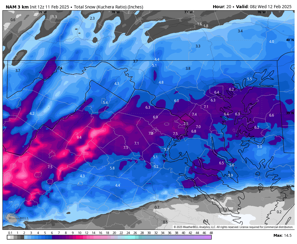
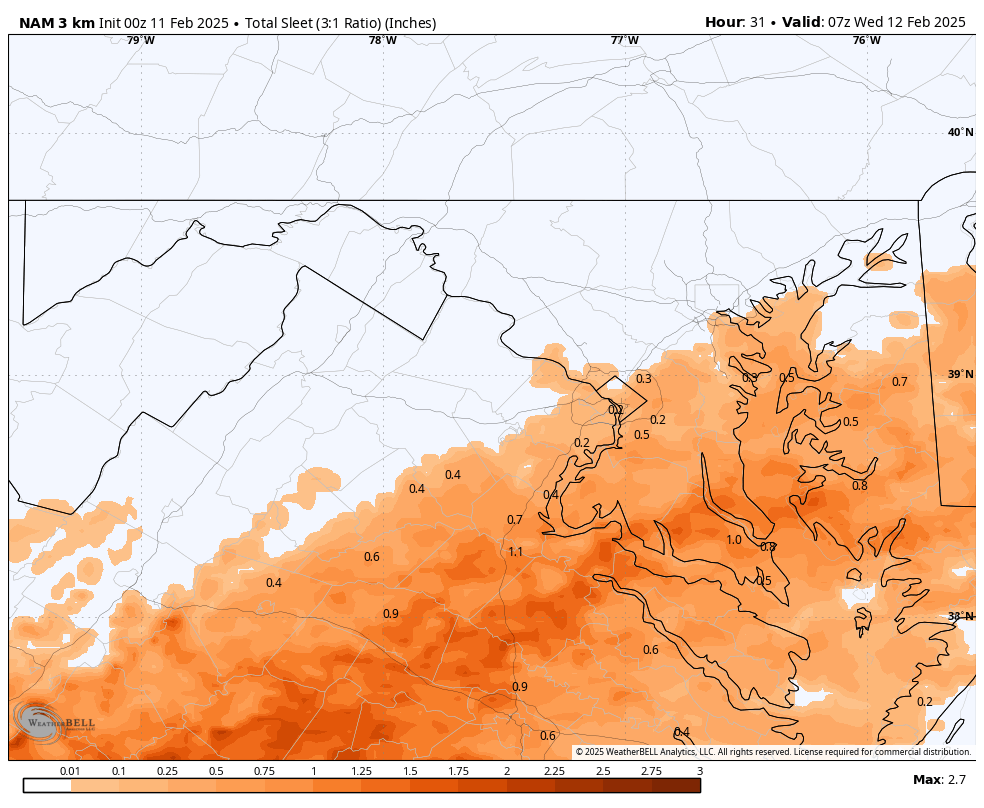
2 minutes ago, BTRWx's Thanks Giving said:
That is in addition to the sleet right?
Yes - sleet total (ignoring wave #2)
-
 1
1
-
1
-
-
The SREFS and their cores look pretty good but we banned them from this forum so i'll hold off
-
1
-


Feb 11-13: Nowcast/Obs
in Mid Atlantic
Posted
It's not really supposed to do anything notable for NOVA/DC until like 4pm, if that. Real accumulations are after 7pm. No panic yet.