MillvilleWx
-
Posts
5,530 -
Joined
-
Last visited
Content Type
Profiles
Blogs
Forums
American Weather
Media Demo
Store
Gallery
Everything posted by MillvilleWx
-
This is for the lowlands people in AA county and points east…. I kind of like where we are right now for this one. If you are in Annapolis/Edgewater area, we are probably one of the better spots no matter what model you look at. 5-10” seems very likely. We will likely mix with sleet if you are along and south of Rt50, but I don’t see it lasting too long before we flip back.
-
Alex is a friend of mine and fantastic met. Agreed. I’ve been saying MD32 is probably the furthest north extent of the sleet line, but collapses back as the coastal takes over and the 850-700mb level shifts as the trough swings eastward. Key is the positioning of the 7H and 85F FGEN placement and I feel there will be split maxima with them. Inside the beltway should be good for 5-8” for DC regardless of sleet. I think that’s a fair bar for the area.
-
I’m hoping it’s earlier as I run the QPF desk tonight again. Pretty delicate situation. I will say one of the best areas right now seems to lie between I-70 and Rt50. Almost any solution throws out WSW criteria snowfall, so I’d feel great if you are between that zone.
-
I think giving potential for mixing, I’d say your max will be right around that 8” mark. I think 5-8” is right on the money with the current forecast.
-
I think 4-8” for your hood is a good call based on what we’re seeing.
-
No problem! I’d say they’ll start having a better idea by tomorrow, but remember the dynamics will be different, so banding and such might take near game time for that feature to get narrowed in. I’m hoping that comes to fruition. That has surprise upside if it comes together properly.
-
DC seeing snow in the 4th dimension
-
Oh yeah. I would say 5” at the worst and 10-12” if everything just breaks perfectly. I’d say 6-10” is a great call for your neck of the woods. I’m sure that’s what Sterling and WPC are rolling with as well. The backend fun with the vort pass is going to be the biggest question mark and if that breaks properly, there will be a lot of happy people in here.
-
Blackwater is absolutely gorgeous. My wife and I’s first ever trip away from the area while we were dating was a hike in mid October to see the foliage in Blackwater. I’m sure it’s pristine in the winter with the blanket of snow cover. Enjoy!
-
For large scale synoptic events, I start monitoring trends after 24 hrs. It’s bread and butter is inside 12 hrs. Convection is a whole different story, but thankfully this isn’t convectively driven. It’s fun to look at now, but I’m very certain it’ll change. But man would it be sweet if it were right right now…..
-
Yup! Great call for up there. You guys should have fantastic ratios (11:1 or better) for the entire event. It’s going to be a winter wonderland around the region and I for one am here for it!
-
I have to come visit your area at some point! I haven’t been to Ski Liberty in like 15-20 years. It’s beautiful up there
-
I have you and the northern MD crew around 5-9”. You and PSU should be in a good spot for good ratios and a decent band that setups up along the topography. This is usually a good storm for one of those.
-
I imagine you do well with this setup. Sterling/Ashburn area should stay most, if not all snow. Hopefully the early morning hrs on Monday are nice and thumpy
-
Ohhhhhh yes. We don’t use the snowfall verbatim, but we do utilize the QPF as a base point and generate our own ratios with the NBM mean Snow Ratio a typical starting point. It’s all about know how to interpret the model and use to your advantage. It’s probability fields are also solid.
-
I like 4-6” for you with a potential for up to 8”. I think you’ll have some really good ratios to work with most of the storm. 7H FGEN should be best along the M/D with the 85H FGEN further south. Someone in MD/VA/DE is getting 10+ out of this.
-
The range is the 1st and 3rd quartile (25th and 75th percentile). The mean forecast is the point forecast where you can select it on the LWX Winter page.
-
It might be tough for CTP but I think LWX is square in the line for a WSW. ECMWF has been a rock recently, and that’s good, but it’s primary ensembles that make up the NBM have this a bit further north. The 3km NAM is a good indication that the EC will likely correct north a bit. I could be wrong and everything shifts south from the CAMs, but it’s tough to deviate hard from the NBM at this range. It’s typically good with the axis of QPF. We’ve seen this type of setup before. A strong 85H LLJ will typically favor a bump north at game time. Something the Nest and some of the other CAMs might be picking up on. We shall see! I do think LWX goes with warnings and CTP will be on the edge for the southern tier of counties.
-
I’m surprised he doesn’t just post a screenshot of the ECMWF and call it his forecast. Basically what is usually is. Model blend of 90% ECMWF and 10% DT
-
Fortunately after a watch is issued, warnings are collaborated via office to office and not WPC necessary. We have had some times we were asked to come on in more delicate circumstances for mediation if one office is on the fence or not. Not going to be needed this go around.
-
Agreed. I feel even a north jog of that run would absolutely smoke DC up through Rt50. Hell, even the Nam Nest was disgusting and it's by far the furthest north. Might actually be reeling this one in, Matt!
-
Man, even a slight north shift would be epic for the DC area. Amazing run
-
5H and 7H over KY moving east look very tasty. That should be some good stuff between 00-09z Tuesday
-
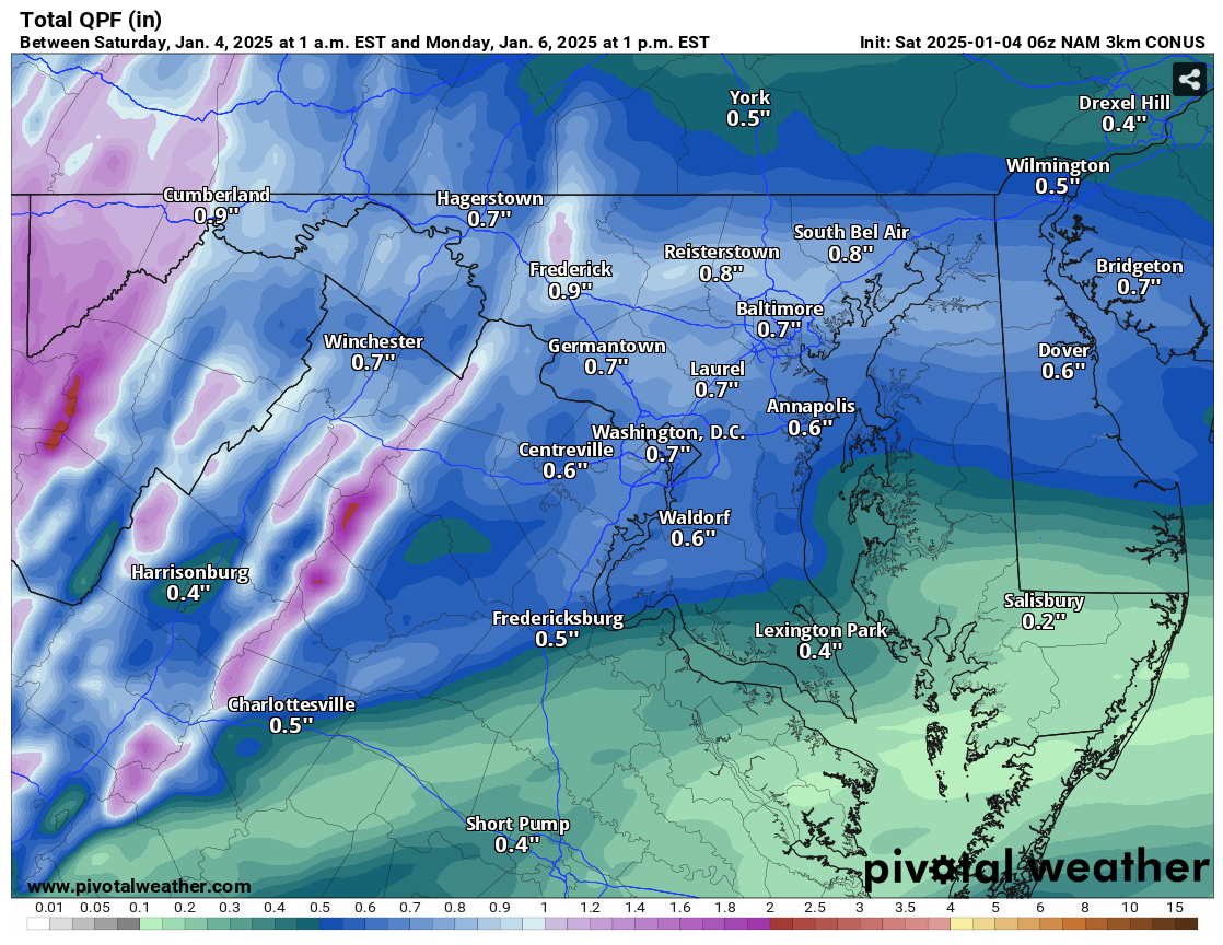
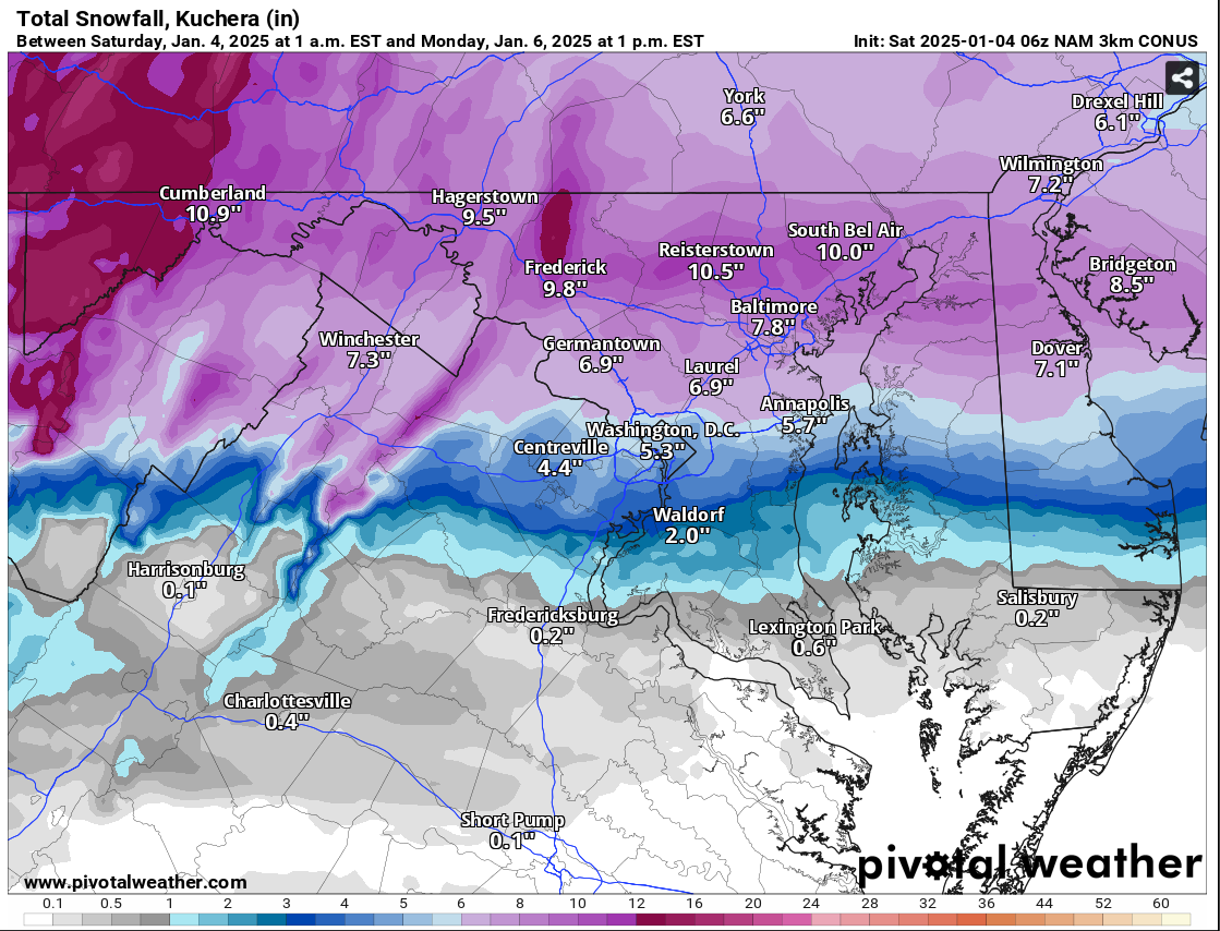
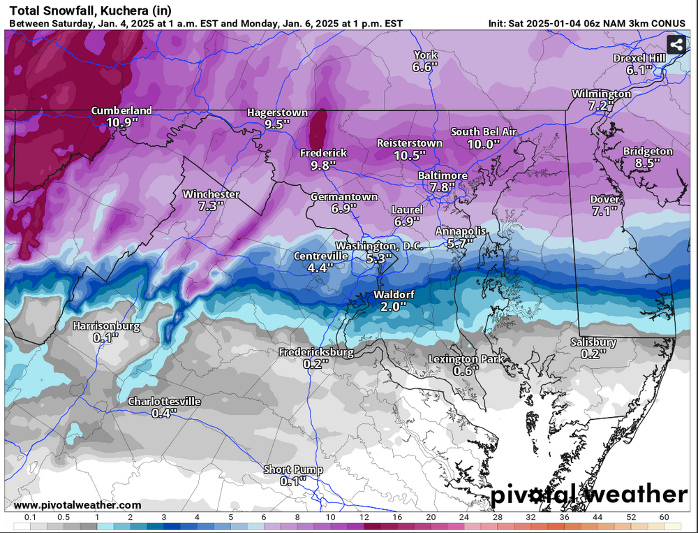
Last but not least, some precip panels from the 06z NAM Nest Total QPF thru 18z Monday (Still more storm left!) Kuchera Snowfall thru 18z Monday

-
Both are useful! There's some 7H FGEN in there as well but the 85H was just incredibly impressive, so wanted to share.