MillvilleWx
-
Posts
5,461 -
Joined
-
Last visited
Content Type
Profiles
Blogs
Forums
American Weather
Media Demo
Store
Gallery
Everything posted by MillvilleWx
-

Feb 22nd/23rd "There's no way..." Obs Thread
MillvilleWx replied to Maestrobjwa's topic in Mid Atlantic
Not so sure about that my man. Here’s through 38 hrs….
-
Central PA Winter 25/26 Discussion and Obs
MillvilleWx replied to MAG5035's topic in Upstate New York/Pennsylvania
For your viewing pleasure!! Should be a great storm for many in here. I hope y’all get hammered with the goods!! Will check in tomorrow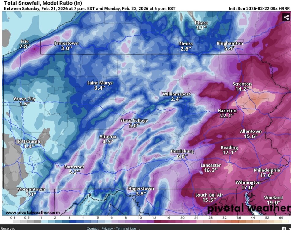
-
Feb 22nd/23rd "There's no way..." Obs Thread
MillvilleWx replied to Maestrobjwa's topic in Mid Atlantic
Insane Clown Whore Posse? -
Feb 22nd/23rd "There's no way..." Obs Thread
MillvilleWx replied to Maestrobjwa's topic in Mid Atlantic
Yeah. That was insane. Surprisingly, these runs haven’t been on an island. Storm is so massive, so perhaps a nice little surprise? I’d take 70% of what that was and be happy -
Feb 22nd/23rd "There's no way..." Obs Thread
MillvilleWx replied to Maestrobjwa's topic in Mid Atlantic
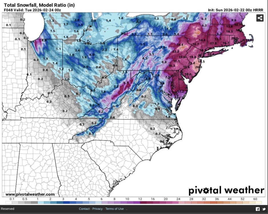
For all you clown map whores, here’s the Model Ratio snow from the HRRR. This is better than Kuchera as it takes into account more variables and verifies better than Kuchera from experience. Nice run for many.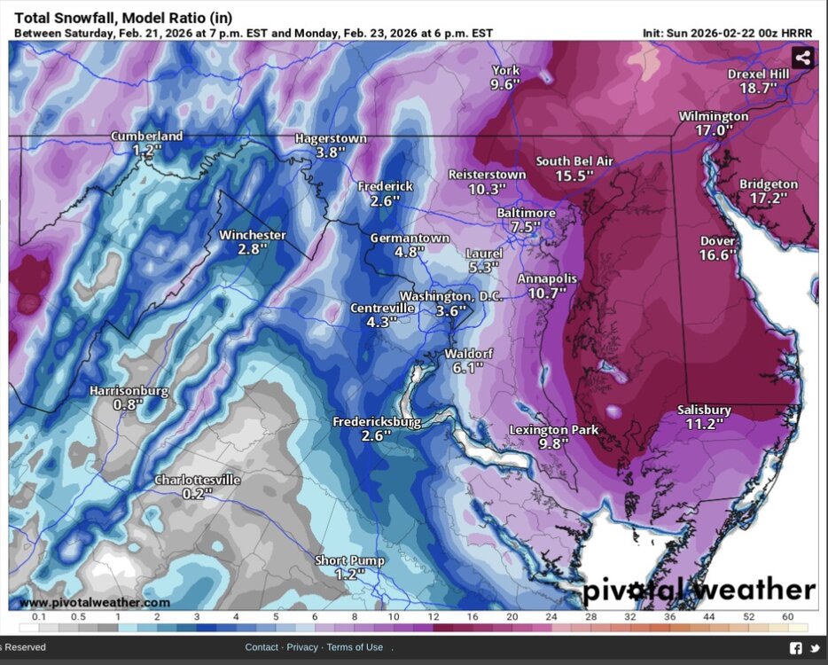
-
Feb 22nd/23rd "There's no way..." Obs Thread
MillvilleWx replied to Maestrobjwa's topic in Mid Atlantic
It is for the western edges but not for the CCB area. That actually improved. A lot of the drier look is from the initial wave being drier upfront. It was too warm at the surface and likely plays a role in the PBL and expected transition later. Will have to monitor that. NAMNest seems to be handling those thermals well, so I’d put more stock in that right now. Surprisingly, I thought the same, but turns out not to be the case. It’s almost on top of its 18z positioning at 06z Monday at the same 979 strength. Key is the western area was drier while the CCB juiced up. Still churning and burning with a hell of a snowfall for the eastern shore to the northeast. I’m on the edge, but even still 6-8” with it still snowing. Model ratio snow calculation has been excellent in these scenarios, so I’ll be paying close attention to it tomorrow as we move forward. -
Feb 22nd/23rd "There's no way..." Obs Thread
MillvilleWx replied to Maestrobjwa's topic in Mid Atlantic
38°/32° in Londontowne Temps on schedule from forecast here. -
It’s better with ratios, but can still run a little high for these kinds of marginal airmass setups. It had a monster output too, so in all honesty, it’s going to come down to dynamical hi-res now and placement of banding. After 21z tomorrow, everyone will start watching the radar blossom then all hell will break loose. It’s going to be fun to watch.
-
This would be as amazing time as ever to go grab a nice Cajun seafood dinner, sip on something cold to drink and light up the fattest, sticky ickiest blunt ever and just enjoy the winter evening down there.
-
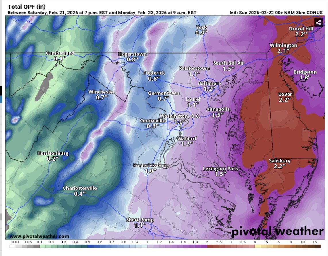
You have no idea how bad I want that to be right, but it’s SLR’s are just too high for this storm. However, it’s QPF is very nice and even with lower SLR’s for this area, it’s one hell of a storm. Insane printout there.
-
Idk how to put this lightly, so I’ll just say it….there will be a relative min for this storm due to the overall evolution and the likeliest spot will lie between the primary deformation within the classic CCB from the surface low and the norlun trough axis further northwest where the converging wind fields develop on the NW edge of the broad mid-level rotation. As of now, the urban areas and true central MD could be the min and the urban areas also have the UHI components to contend with. There’s a better chance for Baltimore to get hit with more snow than DC, but the premise stands. It’s one of the reasons I said I’d like to be east of I-83 and I-97 for this storm. It’s the nature of the beast. Best you can hope is the RAP and NAM’s are on to a broader expanse on the western side of the SLP. That could very well happen, so gotta see how it plays out. Snow will fall and it’ll be moderate to heavy at times before things collapse as the low drifts to the north-northeast. You’ll get snow, but I wouldn’t be surprised to see 4-7” inside 695 and 2-5” inside 495. It is what it is.
-
Good test for the AI with such a complicated and dynamic setup. It’s been west of the deterministic at times, but it was jumpy a few days ago. Seems to be locked in now. Still will miss the banding structures, but the orientation of the QPF is probably fairly good in a spatial sense. I’d lean more towards the hi-res tonight moving forward.
-
I should’ve specified that it was prior to the 12z run the EC deterministic was at the eastern envelope of solutions. It’s adjusted correctly now, but still could be further east as several members are! Sorry for the confusion!
-
For sure! That norlun feature is going to be pretty incredible. I hope you and the WV/Winchester/South-Central PA peeps can catch it if the models have that correctly placed. Easy 1+”/hr rates expected in that thing.
-
Correct!
-
I am tbh. This is such a dynamic setup and the fact we have all the hi-res and regionals adjusting west should give merit. Plus, EC at the eastern envelope of its own ensemble members is a red flag. These solutions with the wrap snow for hours after the meat of the storm is gone is actually classic for these large Atlantic cyclones that occlude. Makes sense the hi-res are showing these solutions.
-
Not so much. I am National center, so it’s only a slight headache lol My disco for the storm is out. Heavy Snow and Ice discussion WPC https://www.wpc.ncep.noaa.gov/discussions/hpcdiscussions.php?disc=qpfhsd
-
I actually am not sure, but can't be a bad thing!
-
ECMWF definitely folded and the 5H progression is great through 00z, then it kicks east-northeast instead of north-northeast like it should on the capture. It's coming into better alignment with other guidance like the GFS and hi-res. It's still a little too dry overall considering the setup, but it's a big shift in the grand scheme and a final fold to how this will materialize. QPF is going to be tough with this one. Our forecast should be on the website now and it's a very sharp gradient from Easton to DC with more east. It's plausible it's too light, but there will be adjustments tonight. Still a general 3-6" for a lot of the region with 5-10" across the M/D from Carroll on east. The norlun trough is a stripe of 6-10" now. That setup is delicate. Updated forecast will be out later.
-
I can promise your house will get more than 3" of slop.....but you'll just have to watch Philly get crushed again.
-
500mb progression on the GFS is actually similar to the HRRR/RAP/NAMNest/NAM in terms of when the height fields close off and their general placements through 12z Monday. The GFS doesn't have anything beyond 09z Monday unless you're at the coast and drifts quickly to the northeast to limit additional snowfall which other models carry. I think it's cutting that off too quickly, and it also doesn't have the leading edge further north into the NW zones and the north-central portion of the sub-forum as it migrates the heaviest further south towards Rt50 and SoMD. I feel the initial is better handled by the rest of guidance. ECMWF is the furthest east, weakest, and driest. Unless is scores a major coup there, it's underdoing things too much, even if it had the "right" idea of being a bit further east. I am forecasting now and I can tell you I will not be using much EC deterministic, but more its ensemble blends to help with the forecast. What you see for the official WPC forecast is mine, so that will be what I think. I'll share when its online.
-
We have tools here at the office where I can look at snow levels of every model and I use them as tools for creating the forecast. Just one of the benefits of being on the desk! AWIPS and our tool integration are very sophisticated. I also look at soundings and check other variables to mentally calculate!
-
Sounds like a field trip to DFH in Rehoboth is in order. Official business
-
Idk who set that up, but that's actually our 90th percentile from our probability precipitation portal. I'm not sure why that says 50th percentile. I just checked and that is, to a T our 90th percentile. And yes, those are automated with an algorithmic process that produces a more gaussian distribution based off our forecast.
-
I think it'll be a little beneficial, but really like areas above 600' for the early stuff tomorrow. Any elevation helps!