Boston Bulldog
-
Posts
820 -
Joined
-
Last visited
Content Type
Profiles
Blogs
Forums
American Weather
Media Demo
Store
Gallery
Everything posted by Boston Bulldog
-
Gotta think a lot of the bigger terrain available off 242 might be in play by now…and I’m not talking about The Dip. @bwt3650 you hearing any rumors? Hypothetically of course
-

First Winter Storm to kickoff 2025-26 Winter season
Boston Bulldog replied to Baroclinic Zone's topic in New England
It's going to take a significant resolution upgrade in order for the AI models to make the jump. Outputs look smoothed, especially at long range -
First Winter Storm to kickoff 2025-26 Winter season
Boston Bulldog replied to Baroclinic Zone's topic in New England
Pretty bad medium range fumble by the Euro-AI. A bit more concerning was just how long and arduous the cave back towards the globals was. Once outputs began to trend, corrections were steady and incremental but far too slow for me to take runs seriously for several days. Model outputs aren't very useful if it's obvious they're playing catch up. The AI Models as they currently stand are a great new tool, but I don't think they're ready to compete with the globals... yet. I guess I currently treat them akin to the Canadian, maybe a tick below. However, I think that in a couple years we may have significant disruption of the current model heirarchy. -
First Winter Storm to kickoff 2025-26 Winter season
Boston Bulldog replied to Baroclinic Zone's topic in New England
Dual lows showing up for both EURO and GFS. Couple more cycles of that and I’d be inclined to say that’s a real feature. Nonetheless, cyclogenesis seems to be going to shit -
Looks like amounts really dropped off south of I-89. Judging from webcams, probably 1-2 windblown inches at MRG/Sugarbush
-
It was clear when they reported 6-10” last Tuesday morning (with a bare Stateside cam no less) that they were going to keep the preseason snow totals very fast and loose. Alta’s 2022-23 season total better look out, Jay’s coming for the 900” crown
-
Looks like Jay’s claiming 34” at the summit for the cycle that ended last Friday (Based off them reporting 21” over the last 48 hours). Coverage up there was great on Saturday, but I would subtract 10-12” from that for sure. It’s not like it was 3 feet of blower that condensed down, the snowpack was dense and surfy with little room for compaction. Love Jay but these reports seem to get increasingly ridiculous. 55” in a drift up against the Tram House perhaps?
-
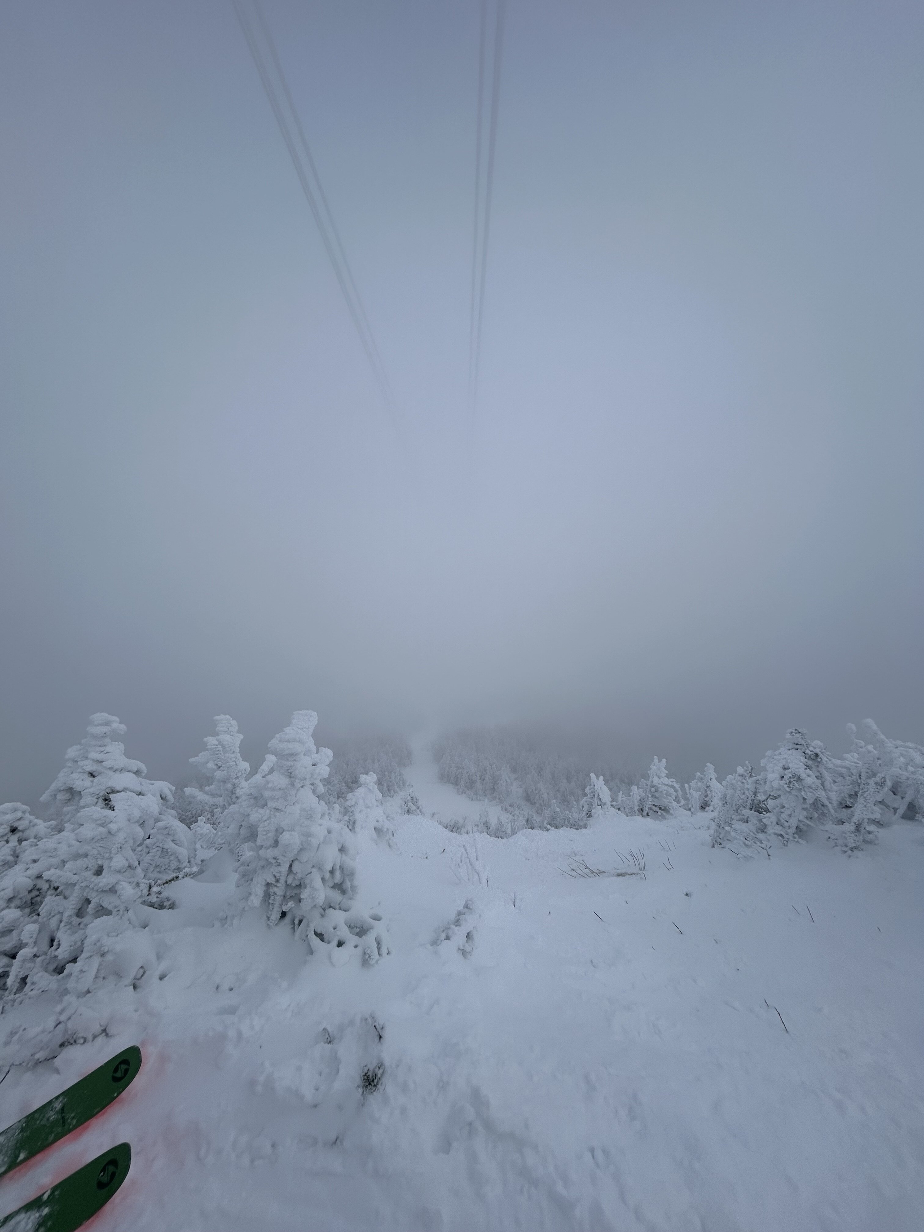
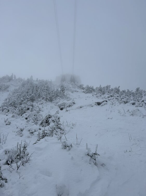
Surfy and supportive, Jay was firing today. Never thought I would see the chutes under the tram be in play in mid-November (albeit with a sharky entrance). Tram ridge hot-laps were excellent all morning.
-
Robust 850mb vortmax about to collide with the spine. Solid upward tick in BTV accumulation forecasts for tomorrow. 5-9” on the point and clicks for favored summits during the daytime period
-
First flakes in Downtown Boston. Hard to even call this a flurry, just a few stragglers making it down
-
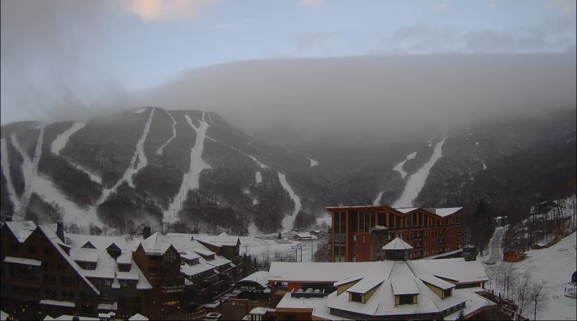
Classic blocked flow this AM. Substantial upslope into the west slopes on radar. Looks like echos stop at the top of the spine, is this beam blockage? No! Clear skies over the Stowe base right now as shown on the webcam, but the eastern extent of the snow showers is very visible over the top of the spine. As froude numbers increase this will push eastward.
-
Back edge swiftly moving north through central VT, maybe up to another inch left for locations north of I-89?
-
Yeah nice 850mb fronto over Capital District and moving north
-
Is blocked flow keeping spine QPF lower than the valley? Hoping more of this can creep over and onto the immediate leeward slopes
-
https://www.weather.gov/btv/froude The paper by BTV NWS linked above is a fantastic overview of the role the froude number plays in orographic precipitation. When cyclonic flow sets up over the mountains, flakes are flying somewhere
-
The developing pack is definitely taking a hit, but in high elevations it should survive the warm up. An extended upslope period is still showing up in guidance and it looks like there will be 2 (or 3) vorticity packets moving through the area through the end of next week to shake the upslope snowglobe. Hopefully soon we're talking about Froude numbers and critical flow, when those terms enter the conversation it's always a sign of a great pattern.
-
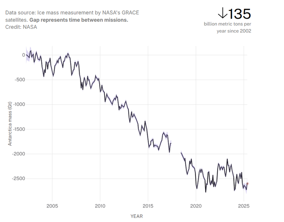
Wolf's stat did pique my interest. Sure enough, ice mass is up in 2025 for Antarctica, but looking at the data over time, I can't see anything saying we aren't melting more and more down there. Context matters, as do proper data analysis methods to properly communicate results.
-
It's these sweeping declarations of ideological talking points in complete ignorance of the painstaking data processes, paleoclimatological advancements, and plentiful data sourcing that goes into these datasets that make it hard for me to believe that these are good-faith arguements backed by substantiated evidence. The data for the Keeling Curve is well documented. The methodologies behind datasets demonstrating trends in temperature and CO2 on the scale of hundreds of thousands of years are the direct result of the leaps and bounds paleoclimate research has experienced in recent decades. All of this is well documented, verified through basic atmospheric chemistry, and published through rigorous peer review. But why dig into something that could potentially be in the opposite of my world view when I can simply say "nuh-uh", "skewed" (whatever that means), or "rigged".
-
Graupel/rain showers south of town currently refracting beams of sunlight just outside the office
-
Regardless of if Sunday Night's event is a snower or cuts west, the cold and moist cyclonic flow looks consistant and filled with potential subtle shortwave features next week. Still a ways to go until confidence increases substantially, but if the pieces align correctly a real solid upslope signature may emerge under the incoming trough.
-
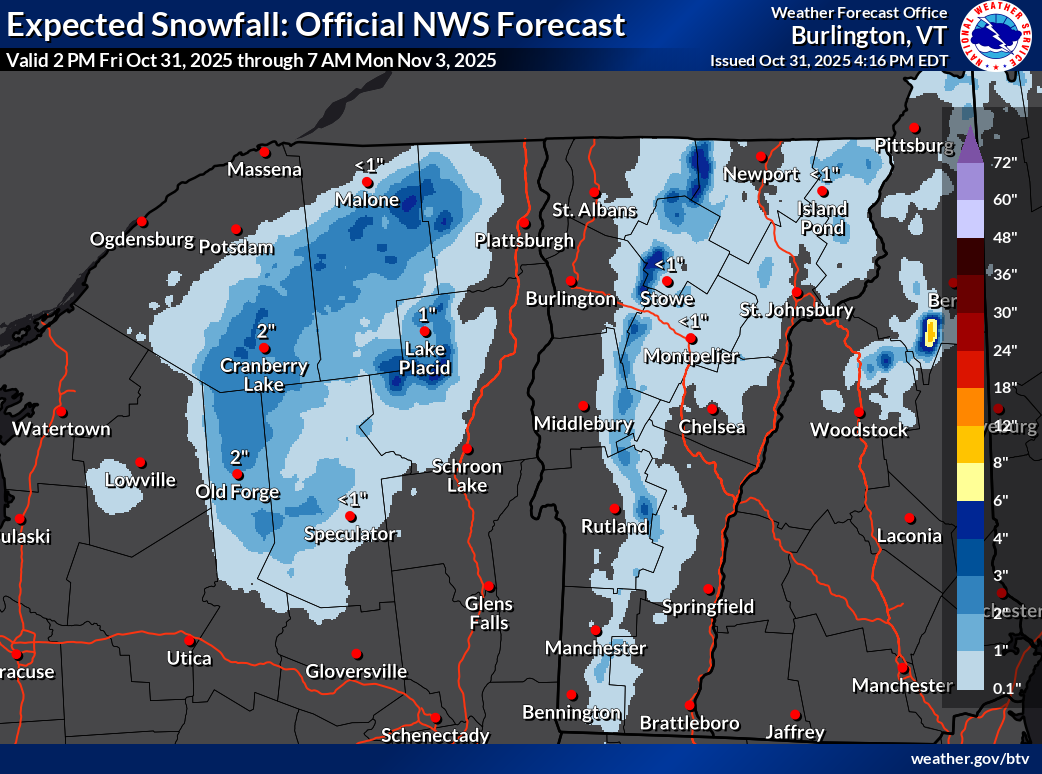
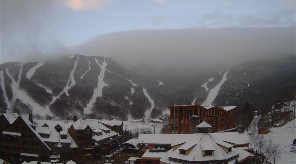
Snow is back in the forecast for the Green Mountain spine, and the BTV AFD is asking the questions we are all thinking... it appears as though cold season is nearly upon us! Looking forward to the incoming stake photos tomorrow morning, may this winter be as cold as the last! .SYNOPSIS... Cool and blustery conditions will prevail for most of this upcoming weekend with occasional valley rain and mountain snow showers. A light slushy snow accumulation is possible above 1500 feet by Saturday morning, as temperatures fall into the upper 20s to near 40. Westerly winds will gust at 30 to 45 mph at times overnight, before slowly weakening on Saturday. Warmer and drier weather returns by early next week, as temperatures climb back into the 50s. && .NEAR TERM /THROUGH SATURDAY/... As of 247 PM EDT Friday...Updated to remove equipment section as TYX radar is back in service. A cool, blustery and showery evening is on tap for Halloween activities. Sfc analysis places an impressive 978mb low pres just east of Sherbrooke with deep/vertically stacked system slowly moving northeast. Storm total rainfall has been 1.72" here at BTV thru 2:45 PM, just imagine if it were colder. This closed cyclonic circulation wl produce a prolonged upslope precip event acrs our mtns thru at least Sat morning, before drier air develops by Sat aftn and precip slowly dissipates. The highest pops near 100% and greatest qpf wl be focused over the northern Dacks and central-northern Greens, with much less in favorable downslope areas of the CT River Valley and parts of the western CPV. Whiteface summit temp already down to 30F with flakes flying and little Whiteface at 3000 feet is 33F, would expect snow level near SLK/Lake Placid by 00z, as progged 925mb temps fall below 0C. For the Green, snow levels start near summit level this aftn, but falls to 3000 feet by 00z and near 1500 feet around midnight. 925mb temps hover btwn -1C and -3C, so a slushy snow accumulation is possible on grassy surfaces down to 1500 feet or so by morning. Expecting 1 to 3 inches btwn 1800 and 3000 feet, 2 to 4 inches between 3000 and 4000 feet and 4 to 6 inches at summit level of both the Greens and Dacks by Sat aftn. Will there be enough for the rock skis and boards by midday Saturday?

-
Major Hurricane Melissa - 892mb - 185mph Jamaica landfall
Boston Bulldog replied to GaWx's topic in Tropical Headquarters
Vortices are likely disrupted and a bit sloppy at lower levels, but this intense convection will help realign and ramp up the reorganization in time. Favorable shear vector will help with divergence. Perhaps Melissa can close off another core, albeit briefly -
Major Hurricane Melissa - 892mb - 185mph Jamaica landfall
Boston Bulldog replied to GaWx's topic in Tropical Headquarters
Agreed, the ongoing contraction of the core as the vortices get back in concert with each other tells me we should see additional pressure falls through landfall. Insanely anomalous to get a Cat-4 strike in this area of Cuba that is so well guarded by mountainous islands. Sandy is obviously the gold standard when it comes to poleward tracking hurricane intensification over the Eastern Cayman Trench (kind of shocked there isn't a more descriptive name that's easy to find for this body of water), but Melissa is putting on an impressive performance. -
Major Hurricane Melissa - 892mb - 185mph Jamaica landfall
Boston Bulldog replied to GaWx's topic in Tropical Headquarters
Given the broader core and limited time over water, I would bet against Melissa re-attaining Cat 5 status. Perhaps flight level winds will begin to resemble that intensity again, but it is highly unlikely those winds would get down to the surface in time. If Melissa had another 18 hours or so before landfall it’s a different story. -
Major Hurricane Melissa - 892mb - 185mph Jamaica landfall
Boston Bulldog replied to GaWx's topic in Tropical Headquarters
Lightning all over the core now, category 4 landfall certainly back in play