

Boston Bulldog
-
Posts
833 -
Joined
-
Last visited
Content Type
Profiles
Blogs
Forums
American Weather
Media Demo
Store
Gallery
Everything posted by Boston Bulldog
-

Rise of the Machines: January 18-19 Winter Storm Obs Thread
Boston Bulldog replied to WxWatcher007's topic in New England
It didn’t initialize correct at all with the first batch or upstream radar -
Rise of the Machines: January 18-19 Winter Storm Obs Thread
Boston Bulldog replied to WxWatcher007's topic in New England
Dumping at Killington. This initial batch got a bit farther north than modeled -
First Legit Storm Potential of the Season Upon Us
Boston Bulldog replied to 40/70 Benchmark's topic in New England
The aggregate trend over the past 24 hours is still really solid. Needs more work, but fast forward from 6z yesterday I’m sure most would take where we are currently -
First Legit Storm Potential of the Season Upon Us
Boston Bulldog replied to 40/70 Benchmark's topic in New England
Man there is going to be an absolutely zonked NAM run within the next 48-72 hours or so -
First Legit Storm Potential of the Season Upon Us
Boston Bulldog replied to 40/70 Benchmark's topic in New England
Longitudinal trends on this will be driven by trough dynamics rather than downstream features -
Brief burst of snow in Central NH. Flipped back to plain rain in New London. 32.9
-
January 2026 regional war/obs/disco thread
Boston Bulldog replied to Baroclinic Zone's topic in New England
If it happens, it will not happen like that -
January 2026 regional war/obs/disco thread
Boston Bulldog replied to Baroclinic Zone's topic in New England
LBSW -
The cold trend continues at 0Z tonight for Saturday night. Net gainer for NNE at this point thanks to the emerging front ender. Don’t look at the cracked out NAM coastal run however, that seems like too much to ask for
-
January 2026 regional war/obs/disco thread
Boston Bulldog replied to Baroclinic Zone's topic in New England
Snow globe shaken in Boston. Big fluffy flakes floating upwards by the office window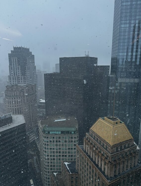
-
January 2026 regional war/obs/disco thread
Boston Bulldog replied to Baroclinic Zone's topic in New England
Great to have your obs from the middle of the Upper Valley radar hole! Probably the worst area of radar coverage in a New England region of considerable population -
January 2026 regional war/obs/disco thread
Boston Bulldog replied to Baroclinic Zone's topic in New England
Very dramatic difference -
January 2026 regional war/obs/disco thread
Boston Bulldog replied to Baroclinic Zone's topic in New England
Paul operates on a different level than most. Was lucky enough to lead write a couple papers in collaboration with him... let's be honest the concept and research was fully driven by his vision. Come in with a question, and he'd counter back with ideas bouncing off the walls and 5 PhD disseration level questions -
January 2026 regional war/obs/disco thread
Boston Bulldog replied to Baroclinic Zone's topic in New England
My advisor from graduate school has a fantastic visualizer of the seasonal cycle of the MJO its associated rossby wave patterns. Very easy to see the troughing over the eastern CONUS in Phase 7 out to day 30: https://www.atmos.albany.edu/facstaff/roundy/waves/rmmcyc/index200reg.html -
January 2026 regional war/obs/disco thread
Boston Bulldog replied to Baroclinic Zone's topic in New England
Yeah that failed handoff is really weird and kinda implausible. The atmosphere likes to stray towards efficient energy conservation, the ping ponging of strengthening between the primary and coastal reflection doesn’t really reflect that principle. I would err towards the primary remaining the more cohesive entity given the modeled dynamics, at least for what the 0Z GFS spits out -
January 2026 regional war/obs/disco thread
Boston Bulldog replied to Baroclinic Zone's topic in New England
Can’t let this cyclone get wound up even a tad or it will cut. However if it gets shredded up into a SWFE, the weekend system is going to set up an intense boundary somewhere. North of that boundary will snow. A warm outcome is still the most likely path forward IMO given pattern fundamentals, but can’t deny the trends today as we emerge into a new time-scale paradigm for the period. It’s no longer looking like a huge ask to turn the tide here, at least for NNE -
0Z GFS continues the trend big time with a SFWE look that halts the warm front’s advance northward. Good to see deterministic guidance showing a cold look is possible.
-
Interesting trend with the warm system late next week. Some OP runs had clean warm sectoring up to the St Lawrence Valley, now the mix line has collapsed substantially south. Honestly I was initially hoping for this thaw to be potent enough to open up a window of soft snow in the Presidentials alpine next weekend. If it's going to get warm, why not prime up some big mountain terrain? Suddenly dreams of spring skiing under gusty SW winds have shifted back to winter mode with hopes of salvaging surfaces on VT honey holes. If we continue to trend to a more forceful push of colder air undercutting the ridge, a decent front ender could be possible OR the longitudinal gradient sags south during the storm (if we have a weaker cyclone and more overrunning look). I'm not declaring an early Feb 2022 like event which neutralized a warm longwave pattern in the Greens, but the plausibility of colder solutions is better than it was yesterday. Either way, I hope the pattern goes all in on either a quick and clean warm spell next weekend, or somehow keeps hammering the cold trend. Getting stuck in the middle seems like a very undesireable scenario
-
Data error for the Mansfield stake? Reading is down to 29”
-
January 2026 regional war/obs/disco thread
Boston Bulldog replied to Baroclinic Zone's topic in New England
Both Feb 2013 and Jan 2015 were modeled to have some sort of stall and loop. While the stalls never materialized, even if they took place the 50” spots would be extremely localized. You’d need to maximize both the initial extreme banding (i.e what was over CT in Feb ‘13) and a CCB type element of the storm, and THEN cash in on the stall via some sort of deformation or decaying mid level banding training over a thin slice of longitude amid what would likely be a shredded occluded mess of a precip shield. Like Will said, for a storm with more widespread biblical totals you’d need a predecessor phase of the event like the overrunnning he mentioned. -
Wounded Duck Strikes Back: Dec 26 & 27th Winter Storm Obs
Boston Bulldog replied to WxWatcher007's topic in New England
Just drove from Greenwich CT to Port Washington on LI over the past 90 mins or so, and the results are excellent for SNE weenies on the NE edge. It was absolutely dumping in CT and Westchester. Approaching the Bronx, the distinct sound of rimed flakes appeared, it was clear warm nose is ferocious and ripping north. By the time I reached the Throgs Neck Bridge, it was all sleet. While planning the drive I only expected a hint of sleet by the time I reached my destination. The forecast is going to bust big time down here. This dead duck is going to come in well north -
26th-27th event, coming at us like a wounded duck.
Boston Bulldog replied to Go Kart Mozart's topic in New England
Gotta wonder how much of the NE edge is virga. Extremely skeptical of those accums in NH. North-south valleys such as the Pioneer Valley may even have some issues too. Extremely cold dry air is going to be advected directly down valley and into the low levels. There are likely to be some maddening discrepancies between radar and reality -
26th-27th event, coming at us like a wounded duck.
Boston Bulldog replied to Go Kart Mozart's topic in New England
NAM looking zonked upstream through 15z tomorrow -
White Christmas Miracle? December 23-24th
Boston Bulldog replied to Baroclinic Zone's topic in New England
Raindrops and 36 in Canton, MA -
December 2025 regional war/obs/disco thread
Boston Bulldog replied to Torch Tiger's topic in New England
It is a pretty exotic blocking regime. Over recent seasons we’ve seen general attenuation of modeled features on the map within 48 hours of verification time, and that isn’t just limited to low pressure. The shredder will hold, but recent modeling biases *may* indicate that it is overmodeled


