Winter Wizard
-
Posts
629 -
Joined
-
Last visited
Content Type
Profiles
Blogs
Forums
American Weather
Media Demo
Store
Gallery
Everything posted by Winter Wizard
-

Central PA - Jan/Feb 2019 Obs and Discussion
Winter Wizard replied to MAG5035's topic in Upstate New York/Pennsylvania
IPT is probably in the best spot among major cities in this subforum. -
Central PA - Jan/Feb 2019 Obs and Discussion
Winter Wizard replied to MAG5035's topic in Upstate New York/Pennsylvania
Less than an inch in round 1 in State College. Based on recent model trends, I'd go with an area of 4-7 inches extending from the Laurels to north of I-80 and across NEPA with 2-4 inches in the LSV. Like with 11/15 and 1/20, how much snow we get depends on how strong the WAA thump is. I'm not sure I buy such a prolonged period of freezing rain that the NAM is showing but regardless, travel will be quite hazardous tomorrow. Great post earlier by @djr5001 showing the comparison between obs and soundings from this morning. Models have a tendency to underestimate the warm air between 850 and 700 mb, so would not surprise me to see an earlier transition from snow as a result. -
Parts 1 and 2 Obs - 2/10-2/12 Winter Storm
Winter Wizard replied to KamuSnow's topic in Philadelphia Region
Hearing about 3 inches in Wilmington with moderate snow falling. -
Central PA - Jan/Feb 2019 Obs and Discussion
Winter Wizard replied to MAG5035's topic in Upstate New York/Pennsylvania
Approaching 4 inches in State College now with moderate to heavy snow persisting. -
Heavy snow here in State College, probably 3 inches or so.
-
Central PA - Jan/Feb 2019 Obs and Discussion
Winter Wizard replied to MAG5035's topic in Upstate New York/Pennsylvania
Heavy snow in State College. Solid band of 30+ DBZ returns currently bisecting 322 and moving northeast. -
Central PA - Winter 2018-19
Winter Wizard replied to pasnownut's topic in Upstate New York/Pennsylvania
We should root for a stronger system to move in Thursday night into Friday since that would shift the baroclinic zone farther south, allowing this weekend's event to track farther south. Thursday night's system seems like a general 2-4" event across most of the region. For this weekend, I would definitely be more concerned about the ice threat as opposed to snow, especially if I lived N and W of Interstate 81. There is a definite cold air damming signal, which CTP alluded to in the discussion, and it is often underestimated by the models leading up to events of this nature. That being said, strong frontogenetic lifting associated with warm air advection could lead to a solid burst of snow at the start across Central PA Saturday night, as hinted by the 18z GFS. The key to overperforming in this system would be to get strong rates at the start, which would cool the column and allow cold air to stick around longer. Definitely something to watch over the next few days. -
Jan 12-13 Snow Event Obs and discussion
Winter Wizard replied to ChescoWx's topic in Philadelphia Region
I've never seen such a sharp cutoff in snow between my house and ILG before. We got only around 2 inches at my house while areas just barely south of me got at least 5. -
February 13, 2014 and March 2017 were probably the closest to that but both still had a very sharp western cutoff.
-
Best part about this storm was that everyone in this forum cashed in! It’s been a long time since we could say that about a storm. Hopefully this is a sign of things to come this winter.
-
1st Winter Event of 2018-19 Fall/Winter Season
Winter Wizard replied to ChescoWx's topic in Philadelphia Region
We finished with 11.5” at Penn State and between 3 and 4 inches back home in Wilmington. An impressive storm to say the least. -
11.5” is the storm total at the Walker Building. By far the biggest storm I’ve ever seen in November and biggest I’ve seen in State College, wow.
-
Absolutely pouring snow in State College. Probably pushing 4” now.
-
I’ll actually be on there live later today lol
-
Snow has started in State College.
-
1st Winter Event of 2018-19 Fall/Winter Season
Winter Wizard replied to ChescoWx's topic in Philadelphia Region
The yellow/orange band set up over Wilmington is moderate to heavy snow, no sleet. -
1st Winter Event of 2018-19 Fall/Winter Season
Winter Wizard replied to ChescoWx's topic in Philadelphia Region
I’m actually in State College but reports back home is it’s still just light snow. I’m guessing the yellows are where sleet is mixing in. -
1st Winter Event of 2018-19 Fall/Winter Season
Winter Wizard replied to ChescoWx's topic in Philadelphia Region
Snow has started in N Wilmington -
1st Winter Event of 2018-19 Fall/Winter Season
Winter Wizard replied to ChescoWx's topic in Philadelphia Region
Last one around here was 1987 so you’d be correct. A rarity indeed. 29/14 -
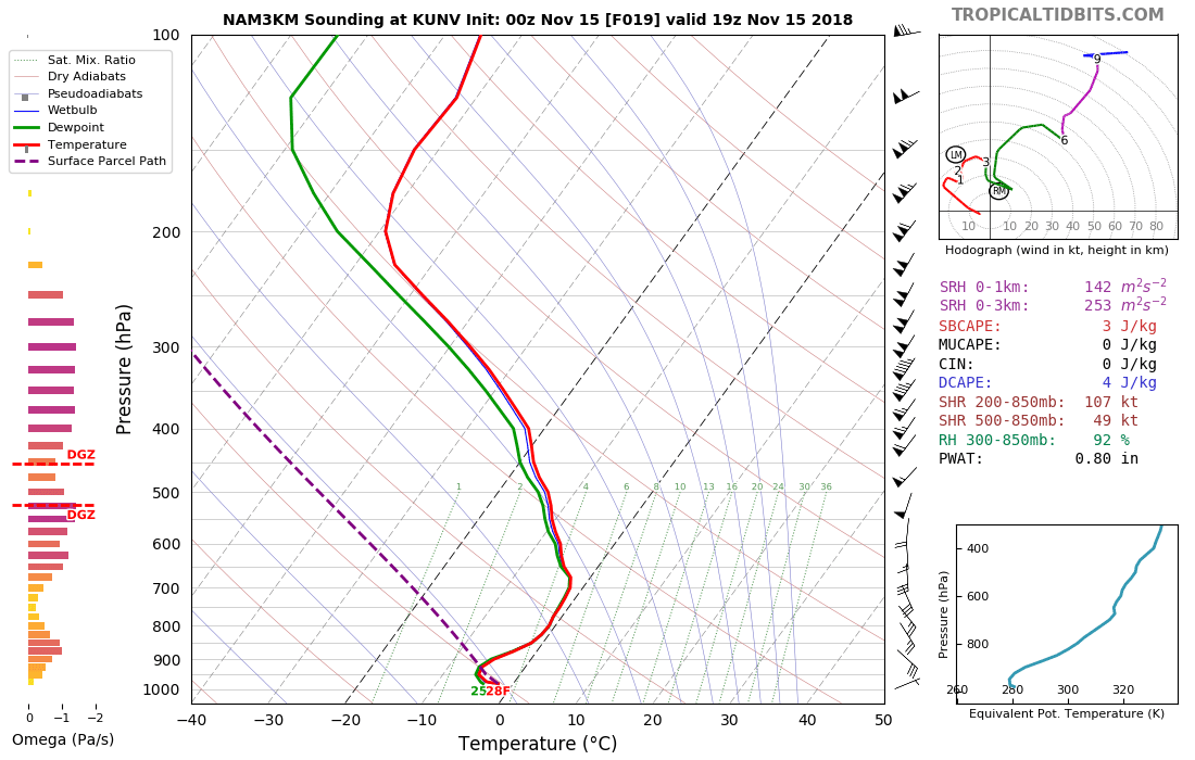
Expect snow to come in like a wall tomorrow. If you believe the 3k NAM this would easily support rates of 1 inch per hour or greater in State College in the afternoon. i would expect a general 4-8” across CTP with isolated up to 10” north of I-80. Trends are definitely encouraging tonight.
-
The 0z NAM actually trended quite favorably for the area. As Ralph mentioned, the high retreating east is a limiting factor, but the system arriving earlier allows for a quick WAA thump before changing to rain. I think that's easily the best case scenario locally although I'd take it with a grain of salt for now. N and W suburbs, on the other hand, could face an extended period of freezing rain or sleet. I feel pretty good about seeing a few inches here in State College, though.
-
Trends have definitely been favorable for wintry precipitation across Central PA especially in higher elevations. It's encouraging that the system has trended to an earlier arrival since that allows for more cold air to funnel in from the high to our north before it exits east. I would definitely be concerned about ice at this point if I lived in the UNV-AOO-JST corridor down through the Shenandoah Valley.
-
Pretty decent chance at severe weather across Central and Western PA through Upstate NY tomorrow. CAPE exceeding 1000 J/KG and shear over 40 knots supports the possibility of rotating supercells, although lapse rates are poor. There will be an MCS moving through early tomorrow morning: we need that move out as early as possible to allow for clearing and destabilization of the atmosphere.
-
Central/Western Medium-Long Range Discussion
Winter Wizard replied to andyhb's topic in Central/Western States
Going to be out storm chasing in the Plains from 5/7 to 5/17. Pattern isn't the most favorable, but should still get a few solid chase days in. -
It'll be quite a show!