

hudsonvalley21
-
Posts
4,078 -
Joined
-
Last visited
Content Type
Profiles
Blogs
Forums
American Weather
Media Demo
Store
Gallery
Posts posted by hudsonvalley21
-
-
-
1 hour ago, Stormlover74 said:
Nam unfortunately jackpots the same areas that got hit hardest last week. 3knam is further south and east
.thumb.png.8bb2c56202a310bae8fec4cd471015db.png)
-
35 minutes ago, wdrag said:
Monitoring for a headline thread of flooding again for Wed-Thu 27-28, maybe topping off I84 with some snow late Friday-Sat.
Still thinking 0.75-2" entire area by the time it quits for a while late Thursday. Of interest to me is potential for 4+" of rain portions of western NC by Wednesday morning which may translate newd. Probably not as serious as a week ago but am pretty sure a few rivers including a couple mainstems in NJ will go back into minor flood, if not moderate flood This event, seems to favor interior NJ/NY/e PA and along and west of I95. Small wet snow accumulation late Friday-early Sat for MA/NCT?
All needing further consideration before wasting anyones time.
Wish there were more wintry to focus upon. I guess patience is my best approach.
Thanks for the heads up Walt, it won’t take much to raise the water levels. We’ll see what the next few runs show. Merry Christmas to you and yours.
-
25 minutes ago, rclab said:
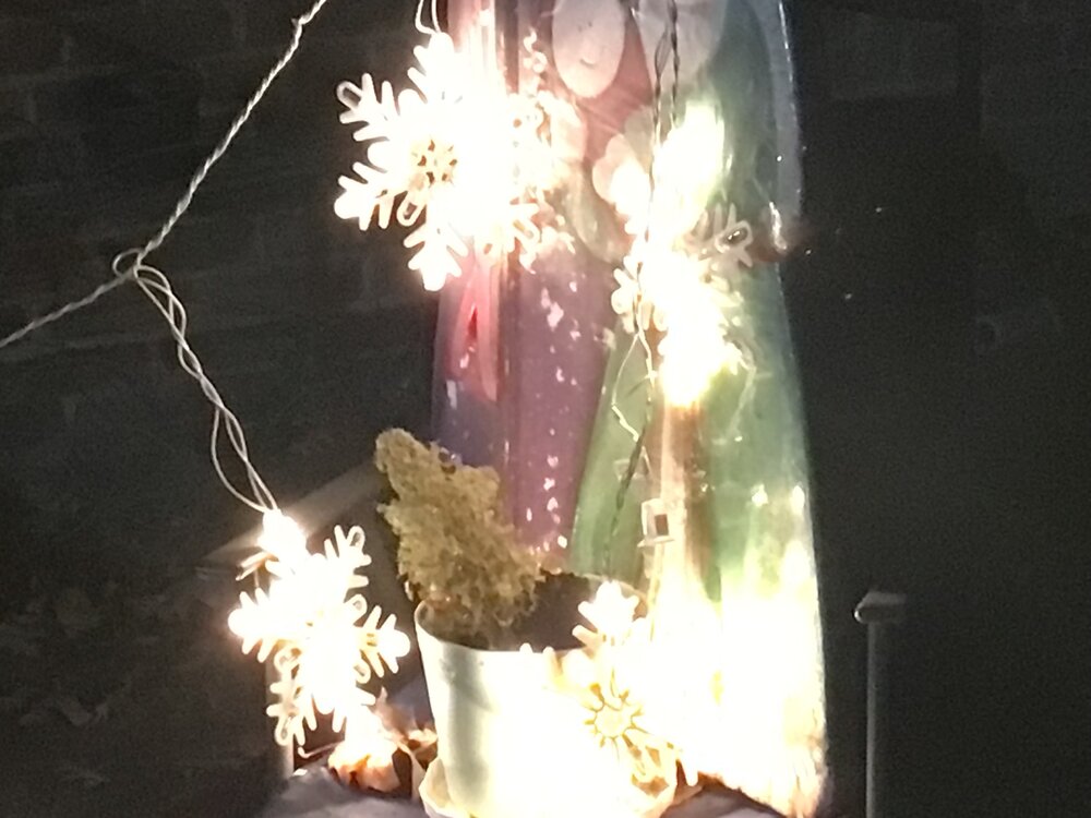
Thank you Julian. Late last night I walked out into the postage stamp, no jacket, just to feel the chill but not very cold Christmas Eve night. I was alone, as I’ve been for the last six years but then I felt I wasn’t. I listened to the unusual quiet of this inner city Sunday night. In the silence I found all I was looking for. The lights of a celebrating neighbor, my four very special snowflakes that regardless of the boundary layer …. never melt and finally looking up I saw through the overcast the light that has never left me. Happy Christmas and blessed New Year to you and all our forum members.
As always …
Rclab, sounds like you have found the Christmas sprit. Have a blessed Christmas!
 Merry Christmas to all !
-
 2
2
-
-
44 minutes ago, CoastalWx said:
It's like a funeral home in here.
No snow on the ground there either

-
 2
2
-
-
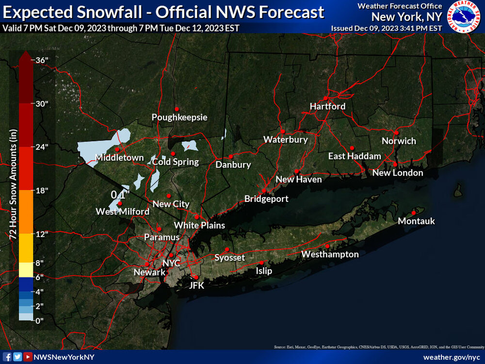
12 minutes ago, IrishRob17 said:
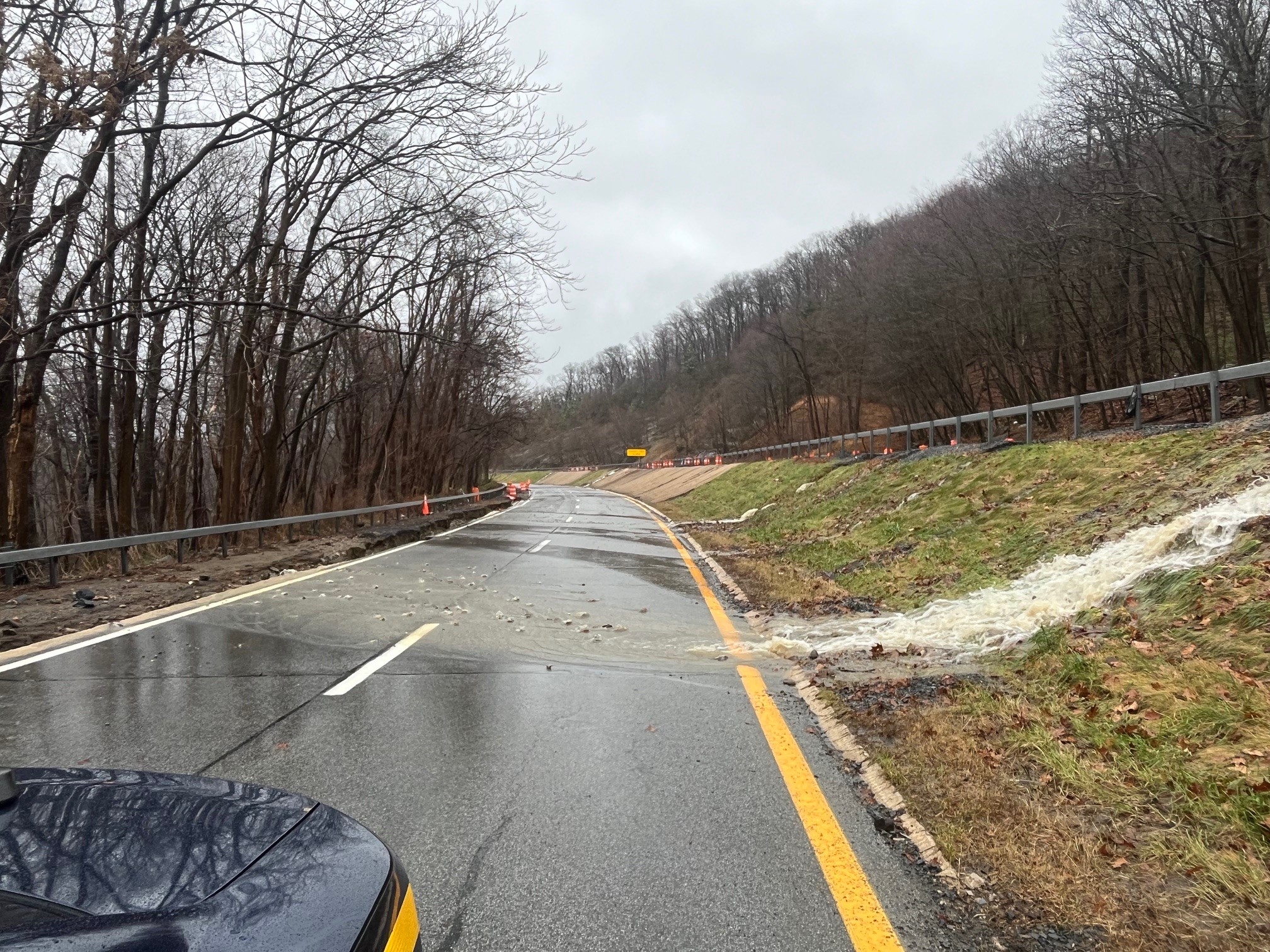
The water gage near the hospital in Middletown is higher now than it was in July, not by much but it also hasn't crested yet, although its getting close.
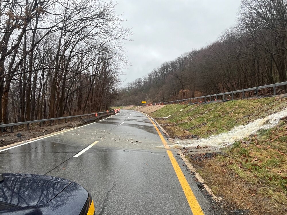
The rain immediately ran off yesterday even after 0.25”. The ground is saturated plus the vegetation that has shut down made an impact on the water levels in the creeks and streams. I heard that there was more road damage on route 6 by the Long Mountain traffic circle from runoff this morning.
From NYS police Facebook
COMMUTER ALERT ORANGE COUNTY: The Palisades Interstate Parkway is closed between exits 14 and 18 northbound and southbound. Traffic traveling north will be diverted to exit 9W to Interstate 87 northbound, except for local traffic. Route 6 and 293 are closed. Traffic will not be able to enter the Palisades south. Commuters traveling north from New York City are advised to stay on Interstate 87
-
6 minutes ago, IrishRob17 said:
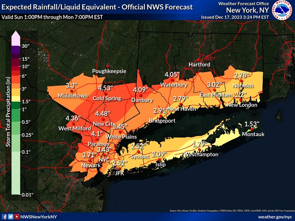
After an average October, and a below average November, right back into above average precipitation with 6.13" so far this month. Sitting right near 65" for the year...why not make a run at 70"? Back in the day we'd say "no way" to that much more this month, sadly nowadays its not as crazy as it may sound to some.
I guess we can call it the new abnormal. The 12z GFS is showing an additional 2” of QPF up till New Years so we could add some icing on the cake. Maybe some of it will be in the frozen type. Always subject to change of course.
")
-
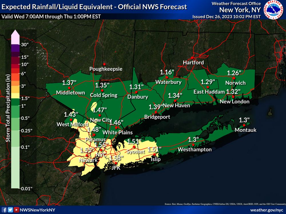
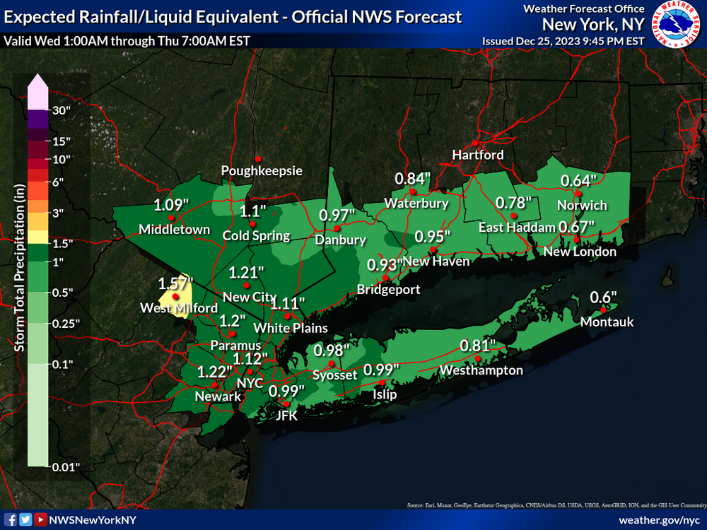
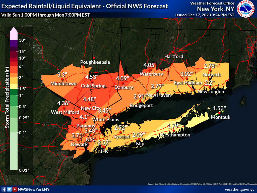
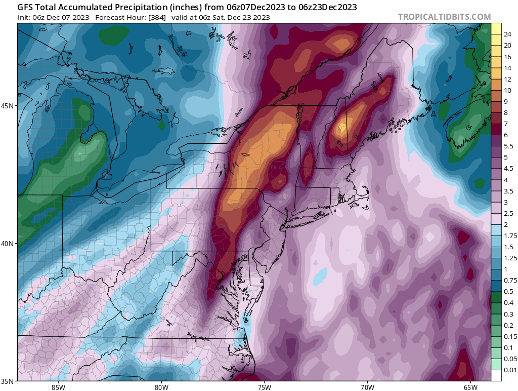
Very impressive system, 3.84 since midnight along with 0.60” Sunday up to midnight gives me 4.44” for the event total.
Upton’s QPF map was spot on for MBY
-
 3
3
-
-
14 minutes ago, IrishRob17 said:
3.03" looks to be the total. Lowest pressure was 983.5mb around 9:30am. After a high of 60 a little after 6:30am we've been cooling, 45/42 currently, will see the sun very shortly.
Very impressive system, 3.84 since midnight along with 0.60” Sunday up to midnight gives me 4.44” for the event total.
-
1
-
-
1 hour ago, crossbowftw3 said:
Last big shot of rain is beginning, will go over 3” for the event with this. Back edge is close
3.70 here so far, backend moving thru now with winds out of the west and 48 degrees. Feel lucky that I didn’t loose power, others can’t say that tho

-
1
-
-
3.72 so far. Backend moving thru currently with moderate rain. Temp is 48 currently down 13 in the last 5 hours.
-
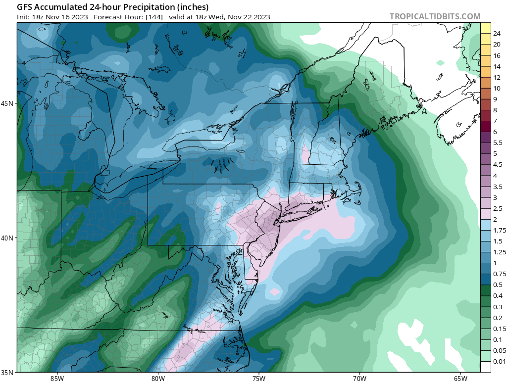
2 hours ago, Snowlover11 said:
yeah they have me getting 2-3” tonight followed by another 1-2” tomorrow.
Same here with the QPF forecasted.
-
-
Upton’s latest QPF map has ticked up a little

-
2.06” in the bucket here.
-
Upton put some spotty accumulations up this way.
-
1
-
-
2 minutes ago, Rjay said:
Bluewave > weenie of the decade runner-up
Maybe send him a hat for a prize

-
1
-
2
-
-
7 minutes ago, Allsnow said:
Anywho…close the shade for a while on cold/snow in our location. Hopefully Sunday is interesting with the wind. Looks like another sloppy jets game
Agree, it will take awhile for the pac jet to get shifted. So maybe we can get an occasional snow shower/mood flakes. It’s too early in the season to start pulling hairs out of our heads watching each model run. As for the jets, this season they could play sloppy inside a closed dome

-
3
-
-
9 minutes ago, gravitylover said:
I have a few flakes, maybe it gets better. Yesterday I got .3, I don't think that'll happen again.
Mood flakes here currently. Had a quick coating yesterday on grassy surfaces that quickly melted. Maybe I can beat yesterday’s and get a trace of accumulation today.
-
Just now, MJO812 said:
It's coming
Things are looking good

Nice, let’s see what future runs show. 06z GFS is showing a few events too (mostly liquid) always subject to change of course.

-
Coating on grassy surfaces that quickly melted.
-
DCA _NYC _BOS __ ORD _ATL _IAH ____ DEN _PHX _SEA
1.4 0.1 0.4 1.7 1.3 1.1 2.3 1.2 2.7
DCA _NYC _BOS __ ORD _DTW _BUF ____ DEN _ SEA _ BTV
12.0 31.0 30.5 33.5 32.5 68.5 59.5 5.5 77.0
-
1
-
1
-
-
Drove thru a snow squall around 11:30 this morning while driving thru Walden. A quick dusting on most surfaces.
-
55 minutes ago, forkyfork said:
turkey bomb

18z GFS is also on board too.

-
1
-
.png.e56ef70694dc3ed5c13555f1ae1c89a3.png)


January 2024 temperature forecast contest _ enter by 18z Jan 2nd
in Weather Forecasting and Discussion
Posted
DCA _ NYC _ BOS __ ORD _ ATL _ IAH __ DEN _ PHX _ SEA
1.5 1.2 1.4 0.4 0.6 1.1 1.3 2.0 -0.8