

hudsonvalley21
-
Posts
3,893 -
Joined
-
Last visited
Content Type
Profiles
Blogs
Forums
American Weather
Media Demo
Store
Gallery
Posts posted by hudsonvalley21
-
-
15 minutes ago, Winterweatherlover said:
The 12z gfs did shift east but it’s really now just in line with other models. Honestly the model agreement of the two storms next week is pretty good right now and they look almost identical except the second one starts out a little colder.
A lot of time to see the trends. Hopefully they are bumps east not west.
-
1 minute ago, SnoSki14 said:
No threats for us whatsoever. No 50/50s in place. Every system should cut well west
A great stretch though for C/N NE and the ski regions up north. Even parts of SNE might do well
Looks like the 12z GFS run has next weeks systems shifting further east from the 06z run. Subject to change of course.
-
1 hour ago, NorthShoreWx said:


Ah, there they are. I prematurely canceled drinking emoticons.

-
 1
1
-
-
1 hour ago, NorthShoreWx said:
Hmmm. Quiet here too.
Here's to snowier times <damn, there's not even a beer emoticon any more> Inconceivable!
2 hours ago, NorthShoreWx said:Hmmm. Quiet here too.
Here's to snowier times <damn, there's not even a beer emoticon any more> Inconceivable!
If we do get a snowy weather event this winter , maybe the mods can add it back for a celebration.
-
 2
2
-
-
Ok how bout a GFS for 1 run.
-
8 minutes ago, MJO812 said:
Weenies throwing in the towel
LOL

-
6 hours ago, wdrag said:
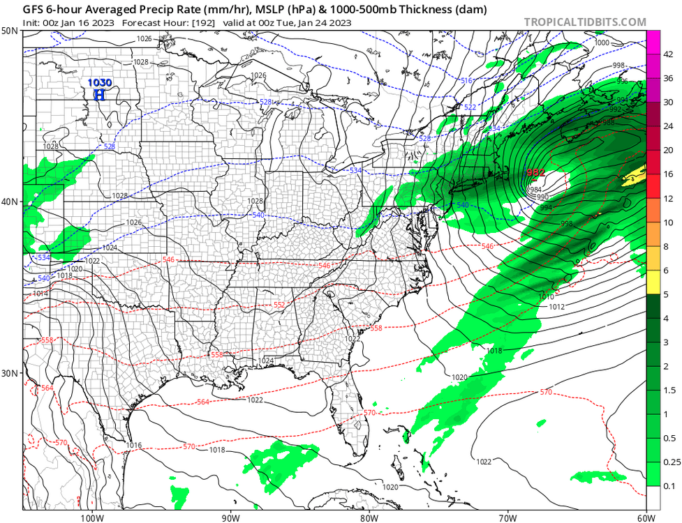
Looking ahead: Aside from what eastern MA and far eastern CT receive from the grazing large ocean storm this Sunday into Monday... it still looks interesting to me for our NYC subforum of the I84 corridor. You saw the spotty 1" amounts yesterday in the Catskills and nw CT, with many reports 0.1-0.7". My perception of what may be ahead and temporarily worthy of monitoring until it does its northeast winter 22-23 M.O. fade to nothing.
Thursday-Friday Jan 19-20 I84 corridor. Significant winter storm compared to what we've had since Christmas, with for now mostly ice to rain I84 corridor but could see some snow involved. Potential for slippery travel, especially high terrain I84. The Canadian Model (overall worlds second or third best model) has been persistent about this occurrence since January 8th.
The following week of Sunday the 22nd-Friday 27th poses one or two wintry weather challenges for the northeast USA, particularly the I84 corridor northward. LOOOONNG ways off=uncertainty on precip type.
Today’s 12z runs are more favorable for the 19-20th event,(still waiting on the Euro run). We’ll see if they start keeping with continuity for the next couple of days.
-
9 minutes ago, IrishRob17 said:
I was driving but didn’t notice thunder.
No thunder here too. Temps up to 48. Up 7 in the last hour.
-
2 hours ago, MJO812 said:
You seriously don't see a good pattern? LOL
Oh now I see it.


-
 5
5
-
-
2 minutes ago, dendrite said:
glad we don’t live there
Warm front pushing thru. Up 6 degrees in the last hour. Up to 47.
-
1
-
-
18 minutes ago, IrishRob17 said:
Pretty impressive lightning out there and thunder snow is much preferred in January rather than a regular thunderstorm. Just saying.
Thunder by you now?
Special Weather Statement National Weather Service New York NY 631 PM EST Thu Jan 12 2023 NJZ002-NYZ067>069-130000- Western Passaic NJ-Putnam NY-Rockland NY-Orange NY- 631 PM EST Thu Jan 12 2023 ...A strong thunderstorm will impact portions of central Passaic, Orange, western Putnam and Rockland Counties through 700 PM EST... At 630 PM EST, Doppler radar was tracking an area of strong thunderstorms centered over Warwick, moving northeast at 40 mph. HAZARD...Winds in excess of 30 mph. SOURCE...Radar indicated. IMPACT...Gusty winds could knock down tree limbs and blow around unsecured objects. Locations impacted include... Newburgh, Middletown, Ringwood, Monroe, Walden, West Point, Warwick, Goshen, Sloatsburg, Cold Spring, New Windsor, Gardnertown, Chester, Montgomery and Greenwood Lake. -
Sleet shower here this morning that flipped over to rain. No accumulation.
-
15 minutes ago, ORH_wxman said:
What do the geese say about the upcoming storm? Any chance it backs further west?
Let me bring one down and I’ll ask it.

-
8
-
-
18 minutes ago, weathafella said:
I know I know I know....but the long range on all ensemble products today are basically epic. We'll give them one last chance before we tell the bat to GFY like in the movie Major League.
I got the t-shirt

-
2
-
-
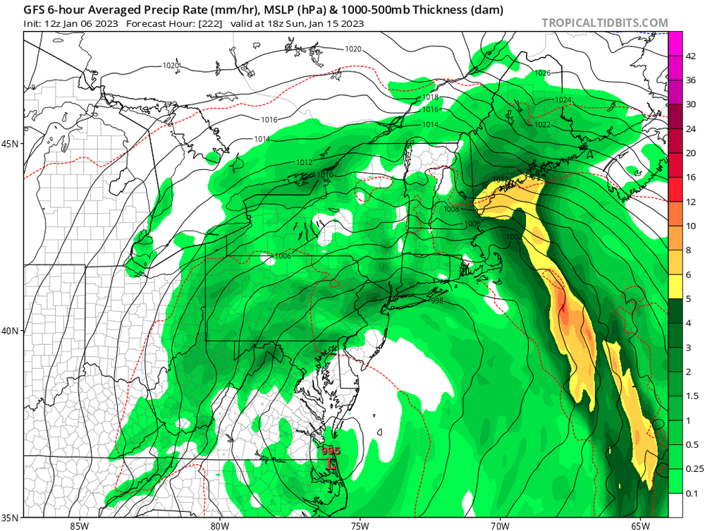
4 hours ago, wdrag said:Aside from tonight per the attached NWS 5AM map (northern edge might be too far north?)Next general wintry mix risk I-84 corridor is Thursday-Friday. This storm has become more complicated so confidence is low on expectations and changes will probably occur in future modeling. A little snow is possible Thursday, and then ice or snow early Friday, changing to rain everywhere. This may provide some travel slow down complications. Meanwhile for nw NJ this seems to be mostly rain. Eventually when this storm moves away later in the weekend, it may end as period of snow but any accumulations would be generally reserved for the Poconos.
-
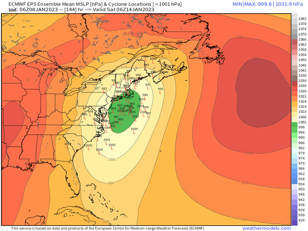
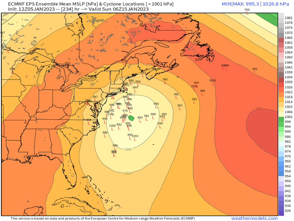
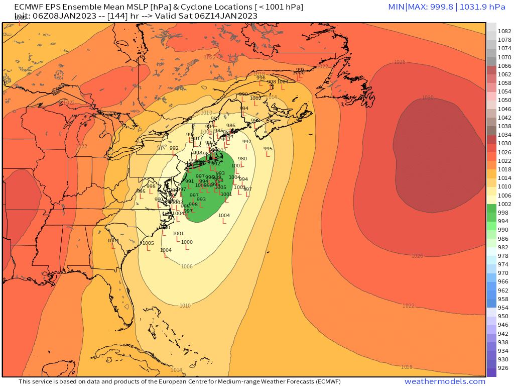
1 hour ago, donsutherland1 said:
The latest ensemble idea concerning the January 13-15 system.
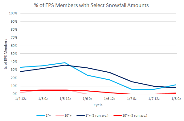
Ensemble support for 1" or more for tonight into tomorrow, which had briefly risen to 25% on the EPS, has fallen sharply overnight. High resolution models will provide better insight at this point. For NYC itself, little or no accumulation appears likely given the warm surface and above freezing readings expected. A slushy coating is possible in the nearby suburbs.

-
2
-
-
1 hour ago, White Gorilla said:
Are we having fun yet this winter?
Only fun so far is writing the check for the heat bill. I did get to fire up the snow blower when I changed the oil in it a month ago. A chance of light snow tomorrow night into Monday morning. Maybe some mood flakes.
-
1
-
-
1 minute ago, EastonSN+ said:
Same 50% for GFS

A slow mover. We’ll see how things unfold.
-
1
-
-
13 minutes ago, MJO812 said:
Post the members
-
4
-
-
000 NOUS42 KNHC 051858 REPRPD WEATHER RECONNAISSANCE FLIGHTS CARCAH, NATIONAL HURRICANE CENTER, MIAMI, FL. 0200 PM EST THU 05 JANUARY 2023 SUBJECT: WINTER SEASON PLAN OF THE DAY (WSPOD) VALID 06/1100Z TO 07/1100Z JANUARY 2023 WSPOD NUMBER.....22-036 AMENDMENT I. ATLANTIC REQUIREMENTS 1. NEGATIVE RECONNAISSANCE REQUIREMENTS. 2. OUTLOOK FOR SUCCEEDING DAY.....NEGATIVE. II. PACIFIC REQUIREMENTS 1. FLIGHT ONE - TEAL 72 A. 07/0000Z B. AFXXX 05WSE IOP07 C. 06/1645Z D. 25 DROPS APPROXIMATELY 60 NM APART WITHIN AN AREA BOUNDED BY: 25.0N 125.0W, 25.0N 145.0W, 45.0N 145.0W, AND 45.0N 125.0W E. AS HIGH AS POSSIBLE/ 06/2030Z TO 07/0230Z 2. FLIGHT TWO - NOAA 49 A. 07/0000Z B. NOAA9 06WSC IOP07 C. 06/1945Z.....(CHANGED) D. 30 DROPS APPROXIMATELY 60 NM APART WITHIN AN AREA BOUNDED BY: 25.0N 140.0W, 25.0N 160.0W, 45.0N 160.0W, AND 45.0N 140.0W E. 41,000 TO 45,000 FT/ 06/2330Z TO 07/0230Z 3. SUCCEEDING DAY OUTLOOK: A USAF RESERVE WC-130J AIRCRAFT AND THE NOAA G-IV AIRCRAFT MAY FLY TWO CONCURRENT ATMOSPHERIC RIVERS MISSIONS OVER THE CENTRAL AND EASTERN PACIFIC FOR THE 08/0000Z SYNOPTIC TIME. 4. ADDITIONAL DAY OUTLOOK: A USAF RESERVE WC-130J AIRCRAFT AND THE NOAA G-IV AIRCRAFT MAY FLY ANOTHER TWO CONCURRENT ATMOSPHERIC RIVERS MISSIONS OVER THE CENTRAL AND EASTERN PACIFIC FOR THE 09/0000Z SYNOPTIC TIME. $$ SEF NNNN-
1
-
-
6 minutes ago, brooklynwx99 said:
these types of setups have produced for us historically

.png.d4fe10b8b1685b46a145c885cb8c42cf.png)
We’ll see. There is a flight scheduled today I believe to analyze the pacific activity. So there will some information inputted into the models. Maybe day or two of updates instead of waiting for theses systems to come onto the west coast.
-
1
-
-
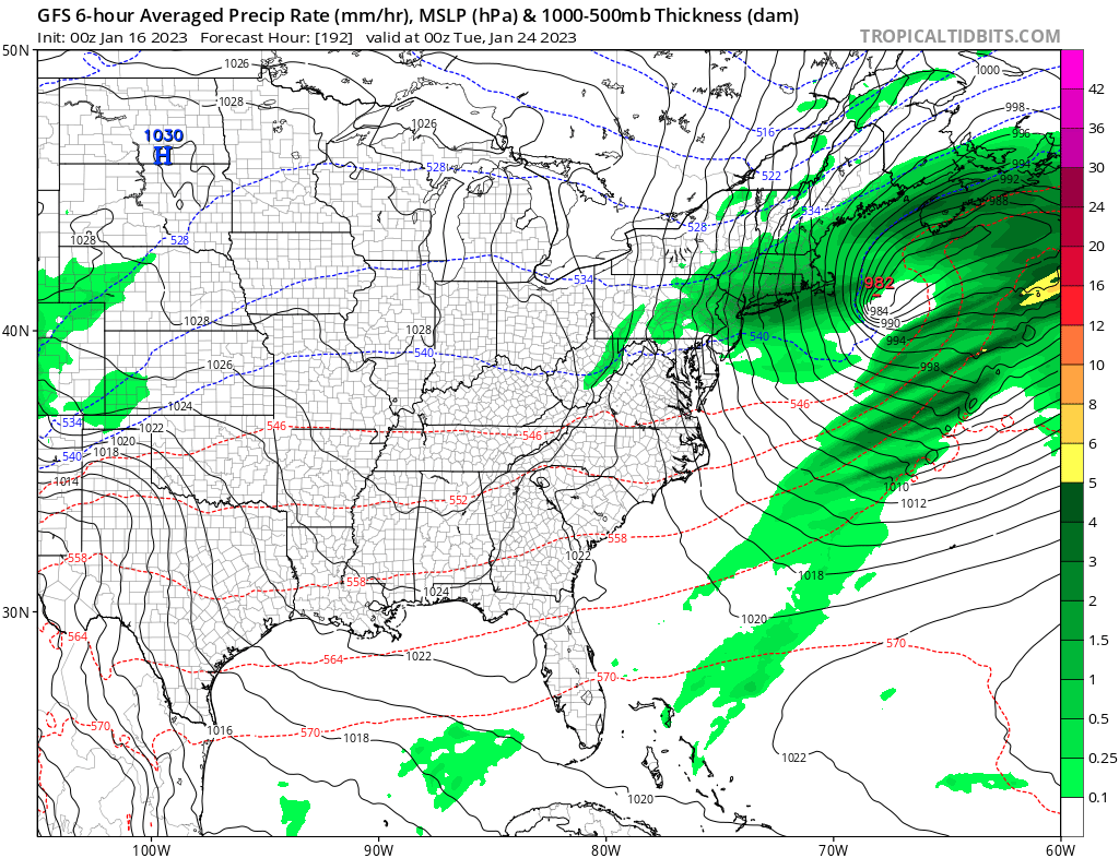
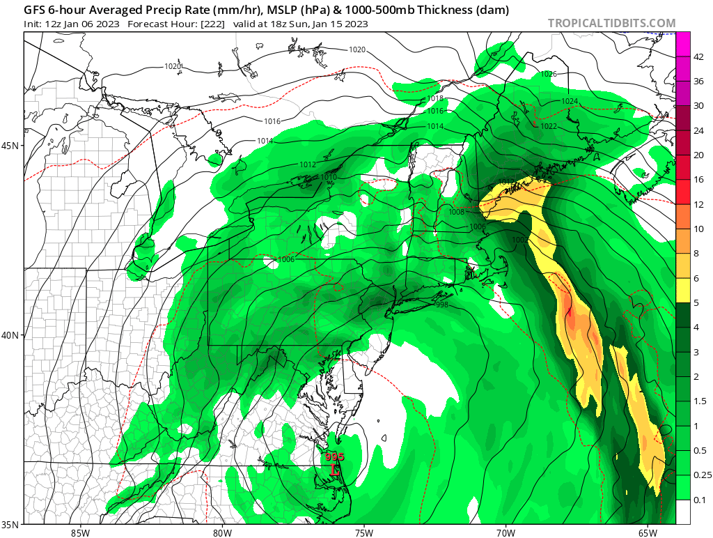
11 minutes ago, ORH_wxman said:
2-4 feet for 1/12-13….can always adjust higher if we need to when we get closer.
-
40 minutes ago, MJO812 said:
Does anyone know how snow looks?
Thank you
-
2
-
-
28 minutes ago, MJO812 said:
Does anyone know how snow looks?
Thank you
Sorry had to do it

-
3
-


January 2023 Obs/Discussion
in New England
Posted