

hudsonvalley21
-
Posts
3,880 -
Joined
-
Last visited
Content Type
Profiles
Blogs
Forums
American Weather
Media Demo
Store
Gallery
Posts posted by hudsonvalley21
-
-
10 hours ago, Hitman said:
got down to 34f this morning.
32 here
-
14 hours ago, BxEngine said:
Now that i think about it….i dont think ive ever even been on main street in goshen. Which is kinda odd considering how much time ive spent in orange through the years at breweries wineries and friends parties etc.
I have the same memory issues after tossing back a few too many.
")
-
 2
2
-
-
55 minutes ago, Stormlover74 said:
And another 1 to 2 on Monday
-
 1
1
-
-
2 hours ago, IrishRob17 said:
My bald head was pelted with ice as I was walking down Main Street in Goshen about 30 mins ago.
Interesting, over on the east side of the county, no event here.
-
1.99” in the Davis for the event total from last night thru midday today.
-
2 hours ago, gravitylover said:
This rain is the real deal. The thunder rocked the house a few minutes ago and the dog got all worried. Lightning and sharp cracks now
") Looks like the fire danger is going down here.
Looks like the fire danger is going down here.
Same here a welcome relief for those brush fires. 0.86 in the bucket for today.
-
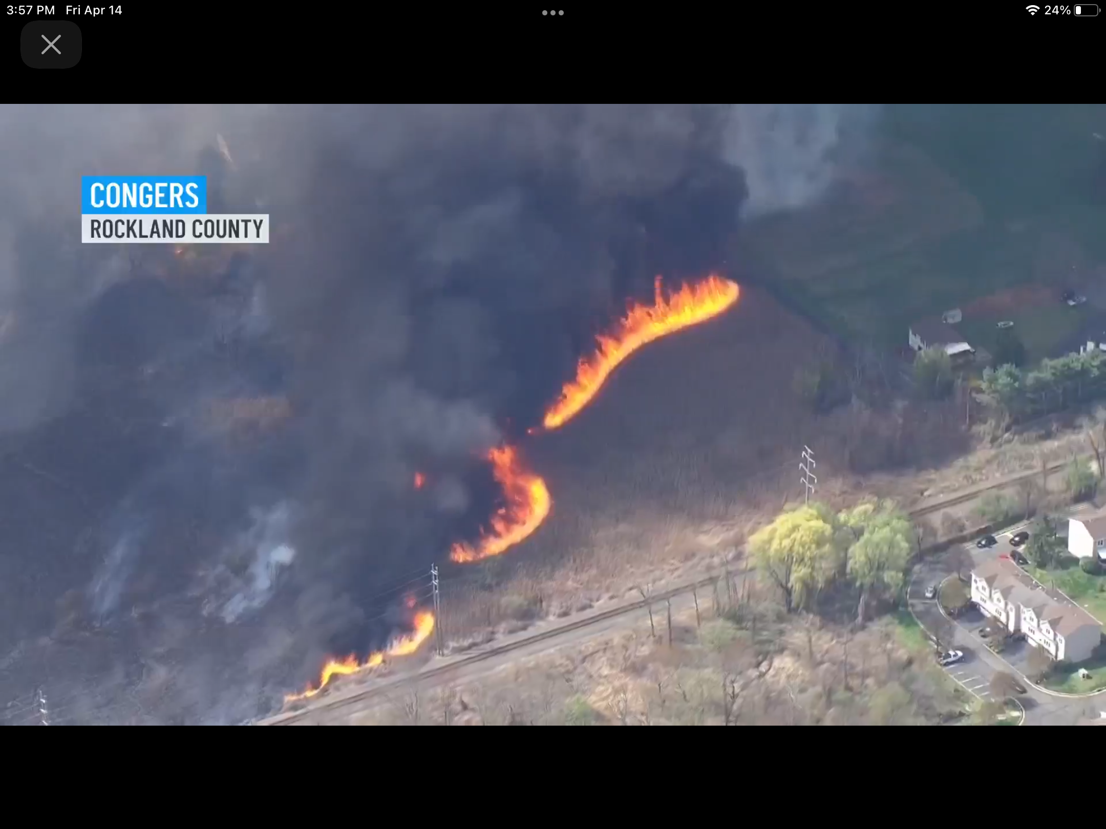
14 minutes ago, IrishRob17 said:
@BxEngineI hope that big brush fire isn't near you or yours. I just watched some video, my guess is a train caused that one
News was just stating that CSX train was the cause
-
2
-
-
From news4 New York

-
2
-
-
1 hour ago, IrishRob17 said:
After a low of 54, made it to 93 for a high, so close to another 40 degree swing. Sitting at 90 now.
Nice, I’m at 91 currently, that was my high for yesterday. Low of 59 this morning made the same 40 degree swing. Forecast high for tomorrow is 71 back to reality I guess.
-
2
-
-
On 4/2/2023 at 5:03 AM, IrishRob17 said:
KMGJ did gust to 49 during one of the windier bursts when the showers were working through.
I was at the Easter egg hunt at the Social Island farm in Goshen Sunday morning. It was 41 degrees with a wind gusting in the 40’s. Amazing too see the black dirt blowing around. The conditions didn’t slow down the kids a bit.
-
2
-
-
2 hours ago, IrishRob17 said:
You had that much rain...AND thunder?!! Had a couple periods of gusty winds that over-performed in comparison to its radar presentation
The wind changed from the west around 2pm along with the dewpts and humidity dropping rapidly put the end of the show for us folks up this way.
-
8 minutes ago, Stormlover74 said:
But they haven't extended that east yet
No and the dewpts are dropping. Currently 41 at KSWF. It was at 57 at 1pm when the wind shifted more westerly.
edit, the humidity was at 78% now it’s 41%.
-
2
-
-
2 minutes ago, Stormlover74 said:
Odd that we're in an enhanced risk but they're not issuing a watch
Mesoscale Discussion 0432
   NWS Storm Prediction Center Norman OK
   0337 PM CDT Sat Apr 01 2023

   Areas affected...parts of eastern Pennsylvania...New
   Jersey...Delaware and eastern Maryland and southern New York

   Concerning...Severe Thunderstorm Watch 107...

   Valid 012037Z - 012230Z

   The severe weather threat for Severe Thunderstorm Watch 107
   continues.

   SUMMARY...Storms may rejuvenate along the front as it moves into
   eastern Pennsylvania and southern New York, with additional develop
   possible ahead of the front from the Delmarva into New Jersey.
   Damaging winds are likely, with a risk of isolated tornadoes and
   large hail by early evening.

   DISCUSSION...Showers and embedded thunderstorms continue to move
   rapidly east with the cold front, with a relative decrease in severe
   wind gusts compared to earlier in the day, due in part to limited
   moisture. East of the ongoing central PA/NY activity, temperatures
   continue to warm, with a recent trend of a few stations reporting
   rising dewpoints across southern NJ and far southeast PA.

   Satellite imagery shows increasing CU over parts of MD, though this
   activity is currently shallow. Over the next 1-2 hours, additional
   storms are expected to form from the Delmarva across far eastern PA
   and into NJ, as lift increases. Some storms may become supercells,
   and the tornado risk will also increase through early evening
   coincident with strengthening low-level shear and cooling aloft. Any
   increase in dewpoints will also increase the probability of a
   tornado. Activity may become linear as the cold front overtakes any
   activity ahead of it, with both damaging winds possible across
   southern NY and New England.
-
20 minutes ago, weatherwiz said:
Hopefully I can chase later. Have to go to New Britain to my niece's birthday party. I'm pumped the Bruins play at 3:00 too...can go after the game.
Full sun here on this west side of the Hudson. 66/57. We’ll see what happens later. Have to watch for those decrete cells before the front.
-
DCA +2.6
NYC +2.1
BOS +2.2
ORD +1.1
ATL +2.8
IAH +3.1
DEN +0.2
PHX +0.3
SEA -2.3-
 1
1
-
-
31 minutes ago, CPcantmeasuresnow said:
5.2 inches in Highland Mills so only added 0.7 since 7:30 dryslotted to light snow much of that time.
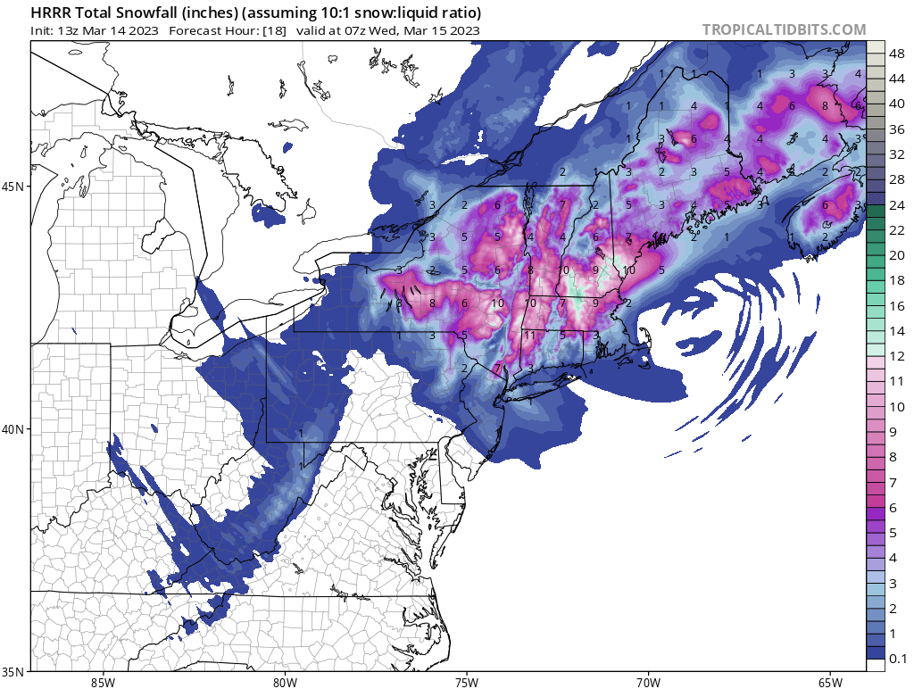
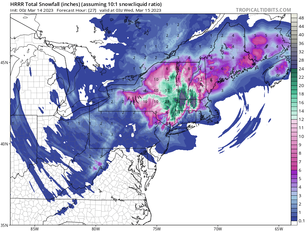
Borderline heavy again in the last 15 minutes at 31.1 and holding. Will snowblow at 11 and see what this hour brings totals wise.Had the same in accumulation. Back to moderate snow currently, temp 33. Super heavy snow, it was like shoveling water. Forecast has another 2-4” for today. Hopefully the winds don’t hit what’s forecasted. HRRR still showing another 2-7” in our area for today.

-
2
-
-
00z HRRR has been basically holding serv for the last few hours. We’ll see how things pan out tomorrow. I’m thinking on the low side of accumulations at my location with the elevation of 125’. Maybe 3-6. Up at higher elevations, it will be a different story.
-
1
-
-
37/36 with a few pingers and flakes mixed in. Elevation 125’
-
1
-
-
37/36 here with a few flakes and pingers mixed in. Elevation 125’
-
1 hour ago, IrishRob17 said:
While weenies are concerned with what the various 10:1 snow maps show falling on their head one thing I think many aren’t realizing is the relatively long period of winds with some decent gusts. It certainly will feel like winter for a couple days.
And the winds slamming the snowpaste on tree limbs and power lines.
-
 1
1
-
-
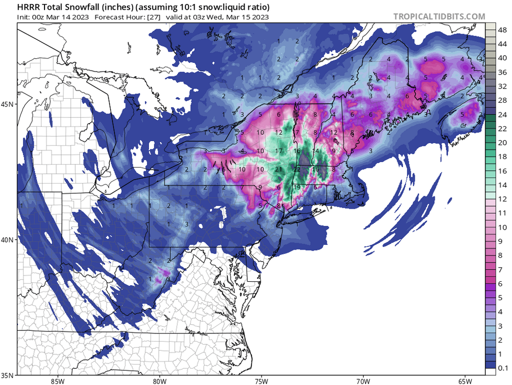
10 minutes ago, ORH_wxman said:
Id prob weight the NAM like 10% right now. It gets more weight once we’re down to about 36h.
What NAM would you lean towards, 3 or 12k?
-
3 minutes ago, jayyy said:
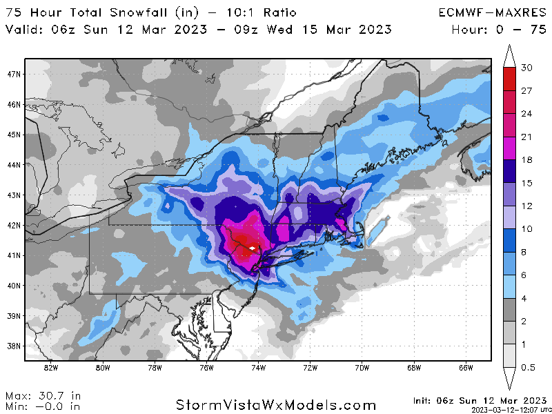
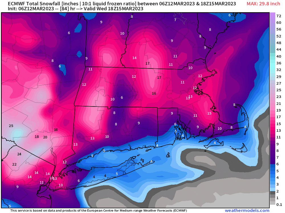
I’d hate to be NWS right now. Euro and Uk show a foot or more for Rockland county and their snow map has 2.8” for new city with no watch up. They seem to be leaning toward the warmer solution and climo - understandably so, but damn! Tough spot to be in if the euro and Ukmet are indeed correct.
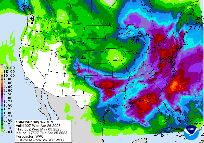
Most models are basically showing around 2” of QPF just to the north of NYC now it’s just what p-type falls and where.
-
1
-
-
-
6 minutes ago, snywx said:
Trying to keep expectations to a min but damn it’s hard to ignore that IVT feature showing up on all modeling for Orange County. 6z Euro is a firehose pointed right into the county.
Agree, it’s been steady for the last few runs.
-
1
-
May 2023 temperature forecast contest
in Weather Forecasting and Discussion
Posted
DCA -0.3
NYC -0.4
BOS -0.2
ORD +0.2
ATL -0.2
IAH -0.6
DEN +1.8
PHX +1.8
SEA +0.4