

FallsLake
-
Posts
6,317 -
Joined
-
Last visited
Content Type
Profiles
Blogs
Forums
American Weather
Media Demo
Store
Gallery
Everything posted by FallsLake
-
The December to Remember 7th-8th blue turd winter threat thread.
FallsLake replied to lilj4425's topic in Southeastern States
Yep, it was the NAM. -
The December to Remember 7th-8th blue turd winter threat thread.
FallsLake replied to lilj4425's topic in Southeastern States
As you said before, this is a tough forecast. We could easily just get a lot of cold rain, or somebody could cash out with heavy rates (..like SC November snow). really not sure what to think at this point. -
The December to Remember 7th-8th blue turd winter threat thread.
FallsLake replied to lilj4425's topic in Southeastern States
Here's the types at hour 96: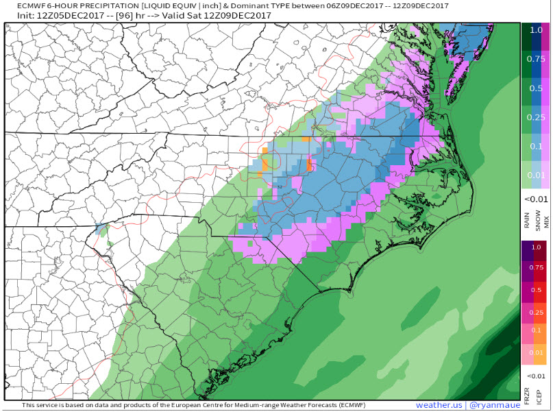
-
The December to Remember 7th-8th blue turd winter threat thread.
FallsLake replied to lilj4425's topic in Southeastern States
I think it looks good for RDU. Mostly snow for the entire event. -
The December to Remember 7th-8th blue turd winter threat thread.
FallsLake replied to lilj4425's topic in Southeastern States
I think it matters on how much initial cold air we can get in place before the storm. Right now it's not looking like much, but dew points will be in the teens right across the boarder into Virginia. If we can get some type of push of that air farther south this could become a good storm. -
The December to Remember 7th-8th blue turd winter threat thread.
FallsLake replied to lilj4425's topic in Southeastern States
Just the messenger.... -
The December to Remember 7th-8th blue turd winter threat thread.
FallsLake replied to lilj4425's topic in Southeastern States
And CR's freezing rain: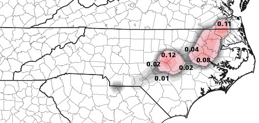
-
The December to Remember 7th-8th blue turd winter threat thread.
FallsLake replied to lilj4425's topic in Southeastern States
Your right. Here's the 12z: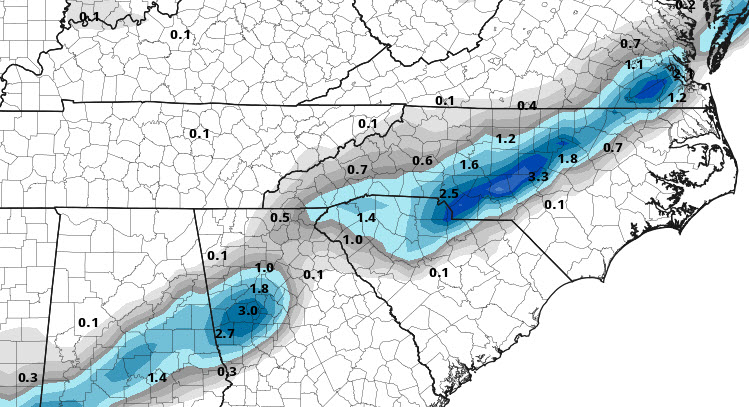
-
The December to Remember 7th-8th blue turd winter threat thread.
FallsLake replied to lilj4425's topic in Southeastern States
Here's a better map from Pivotal Weather: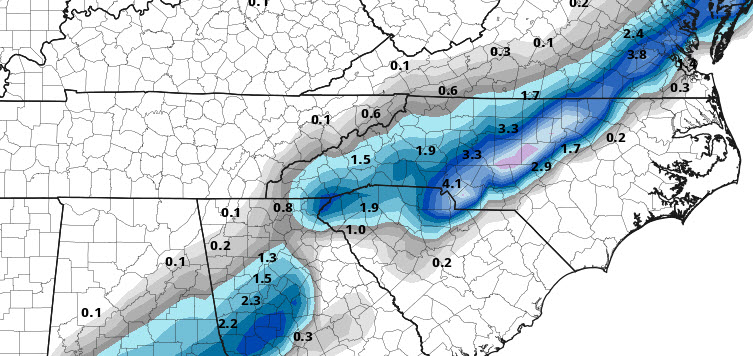
-
The December to Remember 7th-8th blue turd winter threat thread.
FallsLake replied to lilj4425's topic in Southeastern States
CMC is definitely better for MBY. It has colder surface temps, with even some ice showing up over CRs location.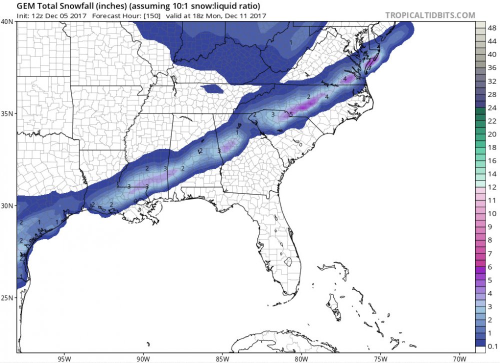
-
The December to Remember 7th-8th blue turd winter threat thread.
FallsLake replied to lilj4425's topic in Southeastern States
GFS at hour 78 is warmer. Just a little snow showing north of Greensboro into Virginia. -
The December to Remember 7th-8th blue turd winter threat thread.
FallsLake replied to lilj4425's topic in Southeastern States
Even with the NAM look, it would be a slush fest. Still I would consider this a win: total accumulation for hour 84: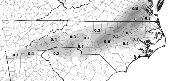
-
The December to Remember 7th-8th blue turd winter threat thread.
FallsLake replied to lilj4425's topic in Southeastern States
I think it would flip back to snow with the heaver rates. Dew points continue to show a colder look (...storm creating it's own cold): -
The December to Remember 7th-8th blue turd winter threat thread.
FallsLake replied to lilj4425's topic in Southeastern States
No the NAM is looking juicy. Our region (as normal) is on the line. But the 84 hour NAM snow fall shows 2-4" across Wake (most for CR), with more to come. You would have to assume most of that would not stick; but still... -
The December to Remember 7th-8th blue turd winter threat thread.
FallsLake replied to lilj4425's topic in Southeastern States
Nam is also ever so slight colder at the surface; especially on the onset. -
The December to Remember 7th-8th blue turd winter threat thread.
FallsLake replied to lilj4425's topic in Southeastern States
Man your right; for me it's got a chance of rain or snow until 1am. -
The December to Remember 7th-8th blue turd winter threat thread.
FallsLake replied to lilj4425's topic in Southeastern States
Here's the 6z NAM at hour 81 (temps at RDU look like 33/32): -
The December to Remember 7th-8th blue turd winter threat thread.
FallsLake replied to lilj4425's topic in Southeastern States
The way things are shaping up; if anybody sees snow flakes falling from the sky, consider that a win. RAH is talking a little bit more about snow (than yesterday): It will be unsettled with a threat of light precipitation persisting for Thursday and Friday as disturbances aloft in the fast southwesterly flow provide sufficient forcing for precipitation. The greatest threat and precipitation amounts are still expected to the south and east of Raleigh across the Coastal Plain and Coastal region. There remains a fair amount of uncertainty in how far north and west the precipitation will extend and the overall amounts. NWP guidances has struggled with this for several days and this is a pattern which is often problematic. There is a reasonable chance that some of the precipitation Thursday morning and especially Thursday night and Friday morning could fall as some wet snow or a mix of rain and wet snow across the Piedmont. The amount of cold air will be the primary limiting factor which should keep things from getting out of hand. Warm boundary layer temperatures, relatively warm soil temperatures, light precipitation amounts, weak precipitation rates and questions regarding the ability of the moisture to extend into the ice nucleation region across the northwest flank of the precipitation axis where temperatures would be most favorable for wet snow suggest a marginal event with fairly high confidence that impacts will be limited. No accumulation is forecast at this point although a few GFS/EPS ensemble members which include unsophisticated assumptions indicate some minor accumulation is possible. After morning lows in the mid to upper 30s, highs on Thursday will range in the mid to upper 40s. Lows Thursday night will fall into the lower to mid 30s with highs on Friday only in the lower to mid 40s. -
^^CR, at least we'll save on the heating bill.
-
Can we keep this thread open through next winter?
-
Not giving up yet, but the writing is on the wall (or has been since January). Really amazing how many days I didn't have to run the heat. Usually in January and February it constantly stays on; this year half the days it was off. Maybe we can pull a cool spring and not turn on AC until late May.
-
I also feel lucky getting what I got. Areas just miles to my south got very little. I have a feeling this spring may end up colder than normal. Seems in years past, after a warm winter spring tends to balance it back.
-
Yep that would be the safe bet. (so)Bring on a 1996 repeat!
-
By the way, if it's going to sleet I say let it stay sleet. If we can get some higher QPF totals that could equate to a decent event. One of my favorite storms was the 1996 sleet fest and that dropped 6" of sleet in Wake forest.
-
I know I shouldn't complain, but I'm on pins and needles for MBY. The short range models have me right on the boarder of the transition. 5 to 10 mile shifts mean very different totals. But if this ends up a sleet fest I'll still enjoy it.

