WxJordan
-
Posts
361 -
Joined
-
Last visited
About WxJordan

Recent Profile Visitors


-
Agreed. The Ensembles have not been bullish in general anyways compared to the OPS, and the Ensembles continue to trend further east and towards a way more suppressed version compared to the GFS.
-
Potential 1/28-1/30 2022 winter storm
WxJordan replied to Prismshine Productions's topic in Southeastern States
Crazy totals up north. Kind of neat set up with the way to energy phases. Doubtful the PJ will be able to dig far enough SW, but that is what would be required to bring snowfall west. -
Potential 1/28-1/30 2022 winter storm
WxJordan replied to Prismshine Productions's topic in Southeastern States
Northeast NC has the chance to do really good again with this system. Mountains will also do well more than likely with upslope. In the middle, accumulations possible, but not a major event at the moment. Rapid deepening as it moves up the coast. Crazy drop in pressure. -
January 20-22 “bring the mojo” winter storm threat
WxJordan replied to lilj4425's topic in Southeastern States
My final forecast I posted earlier today on social media. It was crazy today at work so I haven't had much time to post much. Looking like a good event for eastern NC.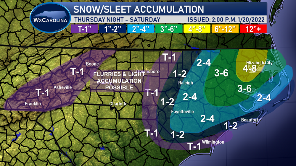
-
One of the best snowstorms for me! I lived in Hickory and it just kept coming and coming. Never will forget it as 2-4 inches was all that was forecasted by the local mets......
-
January 20-22 “bring the mojo” winter storm threat
WxJordan replied to lilj4425's topic in Southeastern States
Its hard, or should I say impossible, for the government to compete against the private sector. -
I have to admit, I have missed the fun of tracking these events with other weather nerds like myself. Glad that I have decided to devote additional time to weather in 2022.
-
January 20-22 “bring the mojo” winter storm threat
WxJordan replied to lilj4425's topic in Southeastern States
NAM is the outlier at the moment. Not sure if I would put a ton of stock into it yet until it gets support from elsewhere. Frontal passages and waves of low pressure are so hard to forecast.... -
January 20-22 “bring the mojo” winter storm threat
WxJordan replied to lilj4425's topic in Southeastern States
The NWS blend has been relatively consistent... If anything the major change has been to push the storm further east away from the Mountains, which makes sense.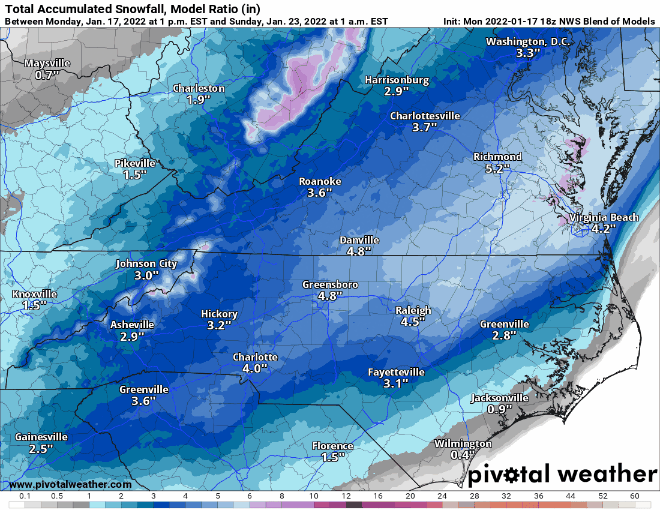
-
January 20-22 “bring the mojo” winter storm threat
WxJordan replied to lilj4425's topic in Southeastern States
I wasn't so much shocked because, in my personal experience, this is playing out as expected. Phasing of the northern and southern stream is not well handled. When a cold front pushes through and stalls, in this case, it is hard for anyone west of 77 to get anything from this system without a strong coastal low. Eastern NC, especially NE NC is the place to be. -
January 20-22 “bring the mojo” winter storm threat
WxJordan replied to lilj4425's topic in Southeastern States
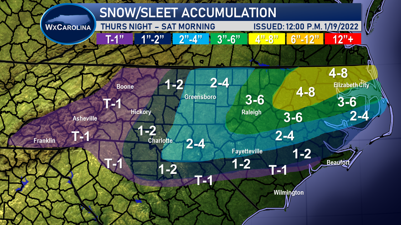
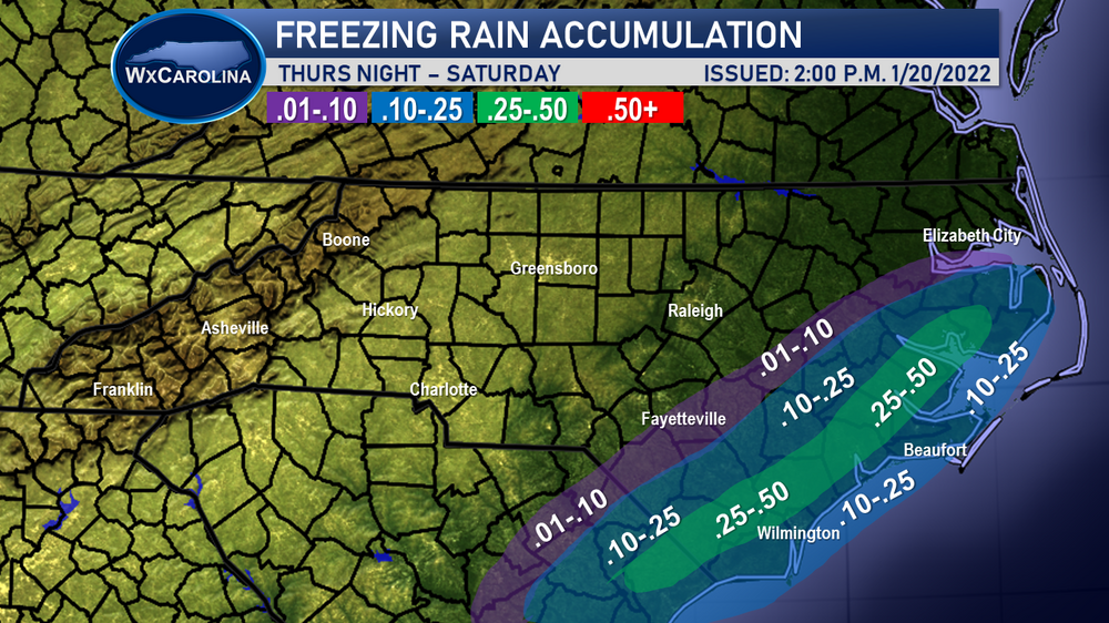
Below is my first accumulation map for the winter weather expected to impact the Carolinas Thursday Night through Saturday Morning. While I am not expecting wintry weather the whole entire time, waves of moisture are expected to cause periods of wintry weather. The highest snow totals are expected in the northeastern part of the state. I am expecting 4-8 inches in NE NC. As we move towards the Raleigh metro, 3-6 inches of snow is expected. Lower amounts as you move further south, but these areas are expected to have more freezing rain. Southeastern NC needs to plan for the possibility of power outages with freezing rain possibly approaching a half of an inch. For western NC and the western piedmont, lower amounts of snow are expected as you will be further away from the best moisture and low pressure center. A trace to an inch is possible in the mountains and foothills, with 1-2 inches possible for I-77, including Charlotte.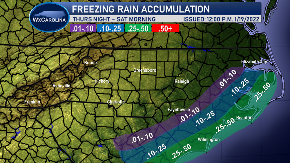

-
January 20-22 “bring the mojo” winter storm threat
WxJordan replied to lilj4425's topic in Southeastern States
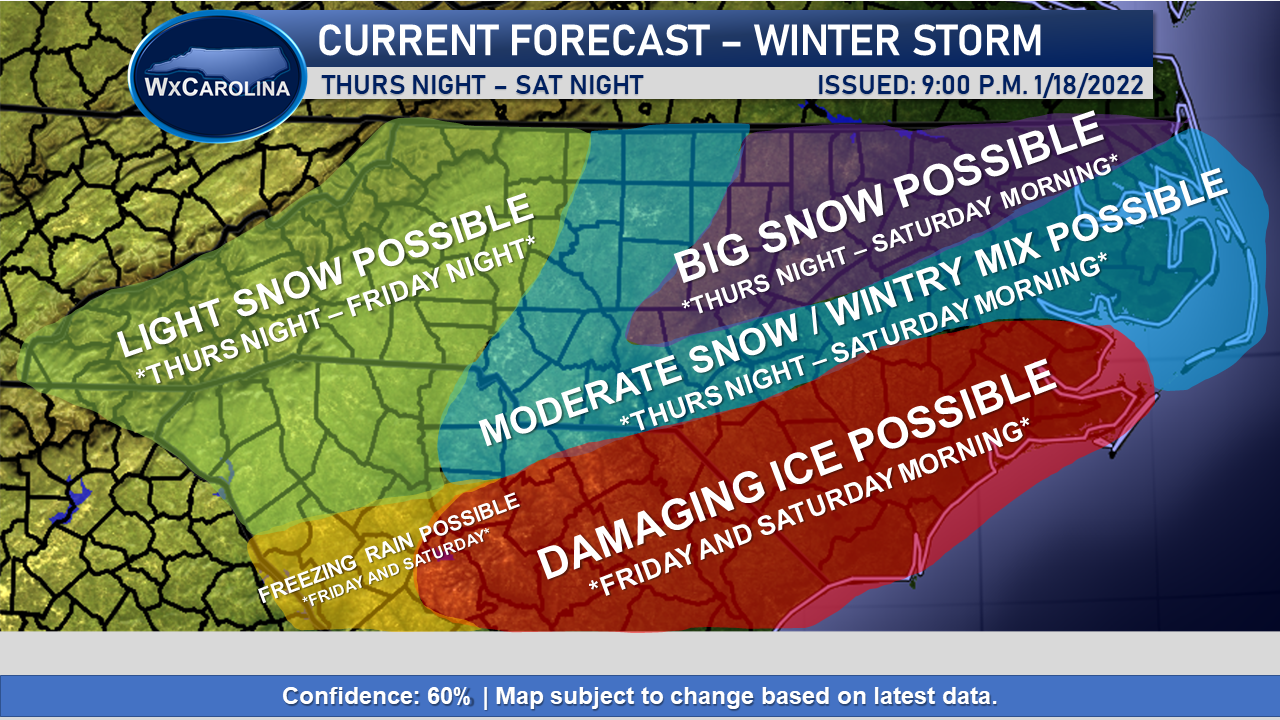
All the models really seem to be coming together on this general idea. Big snows (6+ inches) probably for many areas in northeast NC and southeast VA. I can even see some snow stretching back to CLT and GSO, but the main event will be towards the coast. I am really getting worried about the overrunning ice threat in SE N and NE SC. Could see a really bad situation in this area. Western NC will probably miss out unless something major changes.
-
January 20-22 “bring the mojo” winter storm threat
WxJordan replied to lilj4425's topic in Southeastern States
18z NAM very different in terms of bringing in the southern shortwave later and further west. Would probably be an I-85 event. Very different than 12z runs and I consider it an outlier at the moment. -
January 20-22 “bring the mojo” winter storm threat
WxJordan replied to lilj4425's topic in Southeastern States
Always possible, but in my experience, probably not. -
January 20-22 “bring the mojo” winter storm threat
WxJordan replied to lilj4425's topic in Southeastern States
Maybe. Its hard to wrap around enough moisture with the upper air features and low track. Not impossible, just very difficult.