amc
-
Posts
171 -
Joined
-
Last visited
Content Type
Profiles
Blogs
Forums
American Weather
Media Demo
Store
Gallery
Everything posted by amc
-
Major Hurricane Melissa - 892mb - 185mph Jamaica landfall
amc replied to GaWx's topic in Tropical Headquarters
Looking on twitter for pictures and videos, but not seeing much. Assuming communication and power is very disrupted. Here is an interesting view of this. This is from Cloudflare radar showing traffic from Jamaica over the last 24 hours. Dotted lines are a normal day. Can almost see the storm arrive over time on this graph. https://radar.cloudflare.com/jm?dateRange=1d
-
Major Hurricane Melissa - 892mb - 185mph Jamaica landfall
amc replied to GaWx's topic in Tropical Headquarters
For those interested I've used this site to build a youtube multi-stream view of all the SeeJamaica live cams http://emapp.cc/watch/[{"v":"k4Lt_iev8x4","t":0},{"v":"jVr7_V4Tohw","t":0},{"v":"oB-FPjPS14Q","t":0},{"v":"jJ6C03WtBJE","t":0},{"v":"RHkdQI2PSKA","t":0},{"v":"U67jHOGjH70","t":0},{"v":"pmzJ4AAh0Ds","t":0},{"v":"u70ySp4OuHY","t":0},{"v":"I0w-636mEDY","t":0},{"v":"SPwW9xN3e1M","t":0}] -
Major Hurricane Melissa - 892mb - 185mph Jamaica landfall
amc replied to GaWx's topic in Tropical Headquarters
Their radar site is completely down right now. I looked up some local media and there were no updates today in several. Watching a multicam setup of all available live cams shows many people moving about as usual... -
Major Hurricane Melissa - 892mb - 185mph Jamaica landfall
amc replied to GaWx's topic in Tropical Headquarters
Jamaica's weather service not anywhere close to positioned to handle this kind of event, site often not loading or slowly loading for me. Eyes of the world are trying to watch right now... amazing event about to unfold here. -
AI models picked up on this way before the conventional models…. I think its time to start giving way more stock to the ai models
-
Still very fine sleet... messaged a buddy in Brunswick, freezing rain there... just that little bit of distance making all the difference
-
Deluge of very fine sleet, almost powder. Dunks frozen coffee consistency
-
All quiet here, very brief period of sleet, back to snow, now stopped. Everyone in the neighborhood is snowblowing now... seems like a bad decision, leaving my snow so I can get rid of the snow, sleet and ZR is one shot...
-
Long series of flickers, staying on for now. Little wind to speak of here
-
I'm on the road a lot for work, I've seen plenty of northbound generators but not the rows of line trucks... either their weather people have said don't spend the money or they're actually not ready. Both are very likely knowing CMP lol
-
GYX in with the high wind watches. Euro rips across most of ME, NAM and others more moderate. Morning news seems to be insisting this is a coast only thing with no wind maps yet. Many don't seem to buy it yet. CMP doesn't even have the "we're ready!" messaging on their website yet.
-
December 2024 - Best look to an early December pattern in many a year!
amc replied to FXWX's topic in New England
Considering we loose power on beautiful days up here, this isn't a high bar -
December 2024 - Best look to an early December pattern in many a year!
amc replied to FXWX's topic in New England
Agreed, if it's going to rain and ruin any snow pack, give us something for it. Winds are always fun -
Currently stopped to reassess in Moultonborough, seems further north then most everyone else… general consensus is move south?
-
14" in Gray, ME. Starting to slow to nothing now finally.
-
Biggest issue in Gray, ME right now is there is NO wind, nothing to blow/shake it off the limbs, keeps piling and piling. Can hear cutoffs blowing all around me. Lots of flicking but I'm still on, for now.
-
CMPCO is all over it.... I'm not expecting much, just some breeze pushing the car around on the way to work.
-
1/9-1/10 Now Morphing to Less-Than-Exciting Power Cutter
amc replied to Torch Tiger's topic in New England
About and inch or so I see here in Gray... still coming down pretty heavy... sad to see that all about to go away...... -
1/9-1/10 Now Morphing to Less-Than-Exciting Power Cutter
amc replied to Torch Tiger's topic in New England
28F, just starting to snow, dead calm. -
1/9-1/10 Now Morphing to Less-Than-Exciting Power Cutter
amc replied to Torch Tiger's topic in New England
Wind numbers for my area starting to finalize. Looks like not much beyond the immediate coast here in ME, CMPCO will still mange to just about blackout the whole state probably... -
1/9-1/10 Now Morphing to Less-Than-Exciting Power Cutter
amc replied to Torch Tiger's topic in New England
GYX dropped a bunch of the high wind watches they had out this morning. Euro continues to show gusts only along the immediate coast. Will still cause some issues, rain looks to be the biggest factor, another 3" pouring... -
1/9-1/10 Now Morphing to Less-Than-Exciting Power Cutter
amc replied to Torch Tiger's topic in New England
I didn't even know we had a 'screamer thread' until somebody pointed it out in the Jan thread lol. Euro keeping it coast only... in Maine anyway.
-
10 meters is around 30 feet... I have plenty of pines around me wayyy more than 30feet...
-
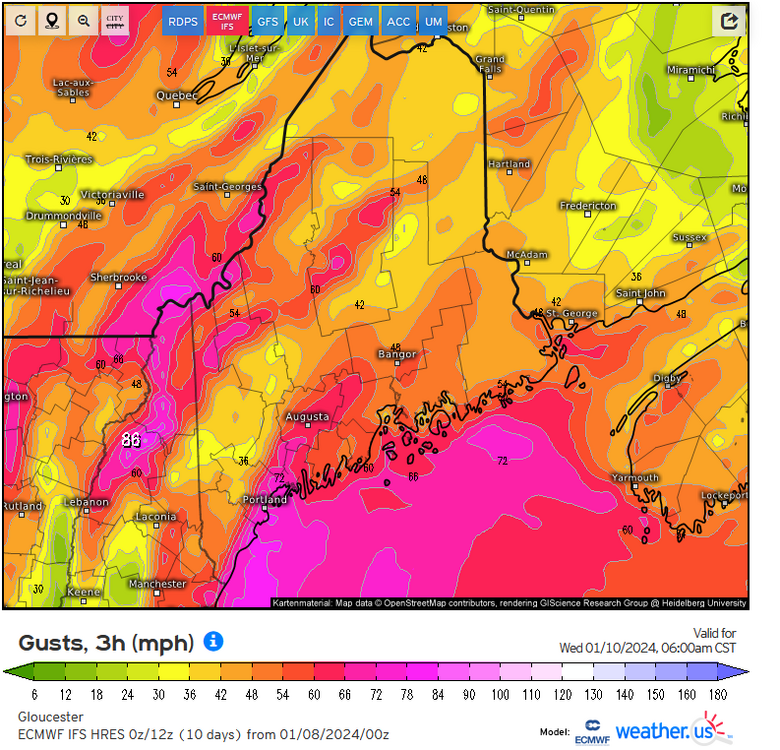
Euro keeps the gusts VERY coastal....
-
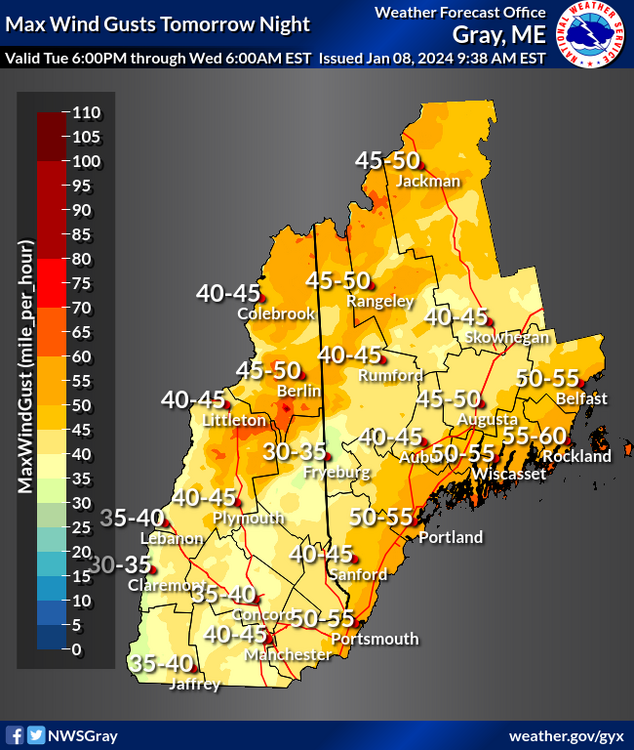
Thanks for the map... I don't think GYX buys it yet. They put out this map, and in their discussion he states the low level jet is going to keep inland from seeing very high gusts. As it stands now that looks to be more inland with 60s and 70s than the christmas storm?