

DDweatherman
-
Posts
6,037 -
Joined
-
Last visited
Content Type
Profiles
Blogs
Forums
American Weather
Media Demo
Store
Gallery
Everything posted by DDweatherman
-
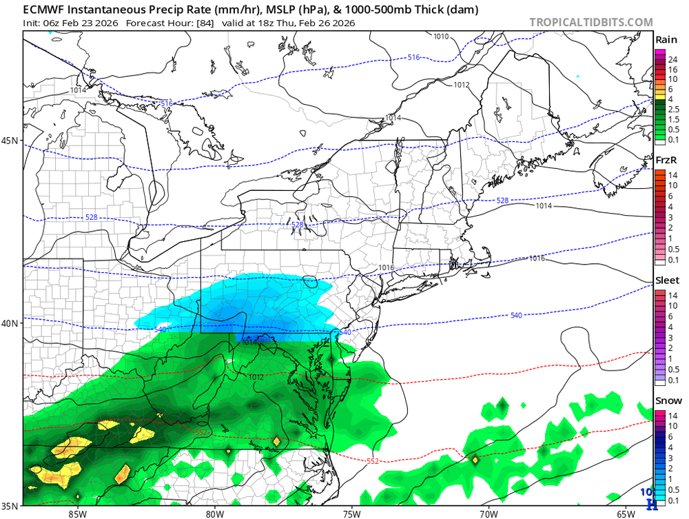
12z suite has the rain/snow battle line across the forum, what else is new? This isn't a 965mb low on the BM, but a much easier way to snow on us if we can. 6z euro shown below. Some of us have had enough of this crap. Let it snow.
-
Late February/Early March 2026 Mid-Long Range
DDweatherman replied to WxUSAF's topic in Mid Atlantic
About 72-78 hours out. I can make a thread if we want to have one. Otherwise we can play here for a bit longer. -
Late February/Early March 2026 Mid-Long Range
DDweatherman replied to WxUSAF's topic in Mid Atlantic
The compromise of the 6z/12z suite thus far is workable for a fair bit of folks. The icon, Nam and rgem are a bit more amped, and the euro is in between. 3 days out. if there’s a thread for this one, I might try and take the wheel. -
Late February/Early March 2026 Mid-Long Range
DDweatherman replied to WxUSAF's topic in Mid Atlantic
I like a little more amped reality, given the trends of the last few systems (vs earlier in the year). We’re less in a de-amped Nina scheme than we were. -
Late February/Early March 2026 Mid-Long Range
DDweatherman replied to WxUSAF's topic in Mid Atlantic
Yo do you even look at the models sometimes? The euro is no more than 50-75 miles from the same thing? -
Late February/Early March 2026 Mid-Long Range
DDweatherman replied to WxUSAF's topic in Mid Atlantic
Great, no school for the kids again on Friday lol. I’ll take it though for 4-6 -
Late February/Early March 2026 Mid-Long Range
DDweatherman replied to WxUSAF's topic in Mid Atlantic
It would be an “easy” path to win, just need that low a bit south. It’s already come 150-200 miles south on some models since yesterday 6z. We get screwed by south trends in Nina, one more for some help this time? -
Late February/Early March 2026 Mid-Long Range
DDweatherman replied to WxUSAF's topic in Mid Atlantic
Also @Bubbler86 it is a pretty potent little wave, models have beefed up on qpf since a day or two ago. Just need to be on the right side of trends inside d3… oh great -
Late February/Early March 2026 Mid-Long Range
DDweatherman replied to WxUSAF's topic in Mid Atlantic
It did indeed. N/w crew is definitely in the game. @clskinsfan it would come on Thursday night. I hope you’re getting plastered with fatties while you enjoy a jebwalk and a brew -
Late February/Early March 2026 Mid-Long Range
DDweatherman replied to WxUSAF's topic in Mid Atlantic
Pretty poor performance for the NAM this weekend, tho no model did that great. RGEM was off by a foot for most people northeast of us. -
Feb 22nd/23rd "There's no way..." Obs Thread
DDweatherman replied to Maestrobjwa's topic in Mid Atlantic
Drive thru Richie rd down the catoctins was sick this morning. Good bit of snow and crazy scenery. Everything plastered in snow, power lines are low. -
Central PA Winter 25/26 Discussion and Obs
DDweatherman replied to MAG5035's topic in Upstate New York/Pennsylvania
Agree, just shitting on every event bound to get it right…there’s a reason our climo is what it is. it’s been a nice wintry morning, snow bands on and off, just had some pretty moderate rates the last hour or so. -
Any reports out of Monmouth county? Red bank, Neptune, asbury?
-
Feb 22nd/23rd "There's no way..." Obs Thread
DDweatherman replied to Maestrobjwa's topic in Mid Atlantic
Snowing quite well at the moment, vis is about 1/2 mile, wintry morning! -
Feb 22nd/23rd "There's no way..." Obs Thread
DDweatherman replied to Maestrobjwa's topic in Mid Atlantic
Those balls are old Mitch, that could be why. -
Feb 22nd/23rd "There's no way..." Obs Thread
DDweatherman replied to Maestrobjwa's topic in Mid Atlantic
At least it’s done something here it almost never does, which is basically snow for 24 hours straight imby. -
Feb 22nd/23rd "There's no way..." Obs Thread
DDweatherman replied to Maestrobjwa's topic in Mid Atlantic
About 4.5” or so, still been snowing all morning. Beautiful wintry scene at the very least. Wife and I took a 6am Jeb walk, it was a great start to the week (before the kids woke up - they had to get another snow day) -
Late February/Early March 2026 Mid-Long Range
DDweatherman replied to WxUSAF's topic in Mid Atlantic
It’s an event where @psuhoffman has best luck and is why climo is higher -
Feb 22nd/23rd "There's no way..." Obs Thread
DDweatherman replied to Maestrobjwa's topic in Mid Atlantic
Some places could get more snow Thursday if there are some positive trends haha -
Feb 22nd/23rd "There's no way..." Obs Thread
DDweatherman replied to Maestrobjwa's topic in Mid Atlantic
Snowing nice here right now under lighter returns, I get it haha. @Bubbler86 wonder whats been going on up in BLS/Pen Mar? They've been under a band for hours. -
Feb 22nd/23rd "There's no way..." Obs Thread
DDweatherman replied to Maestrobjwa's topic in Mid Atlantic
Coming down nicely at the moment here, blowing as well. Somewhere around 5" total it seems with the 2 early yesteday, a clear and about 1.5", then about 1.25-1.5" overnight. -
Feb 22nd/23rd "There's no way..." Obs Thread
DDweatherman replied to Maestrobjwa's topic in Mid Atlantic
It should still be snowing there, no? -
Feb 22nd/23rd "There's no way..." Obs Thread
DDweatherman replied to Maestrobjwa's topic in Mid Atlantic
Still snowing…and picked up a couple inches overnight. Not sure how much, but it looks awesome out there. -
Feb 22nd/23rd "There's no way..." Obs Thread
DDweatherman replied to Maestrobjwa's topic in Mid Atlantic
Happy to report I’m right in the middle of it! Good times -
Feb 22nd/23rd "There's no way..." Obs Thread
DDweatherman replied to Maestrobjwa's topic in Mid Atlantic
Do see those returns @Eskimo Joe is talking about out near Berkeley springs. Hope radar fills that far west.


