DeltaT13
-
Posts
3,006 -
Joined
-
Last visited
Content Type
Profiles
Blogs
Forums
American Weather
Media Demo
Store
Gallery
Everything posted by DeltaT13
-
Upstate/Eastern New York
DeltaT13 replied to BuffaloWeather's topic in Upstate New York/Pennsylvania
I’ll be the first to admit this rain has been more robust than I expected and the best instabilities are still yet to come! Let’s break some records Kbuf -
Upstate/Eastern New York
DeltaT13 replied to BuffaloWeather's topic in Upstate New York/Pennsylvania
God damn that’s a beautiful looking band! -
Upstate/Eastern New York
DeltaT13 replied to BuffaloWeather's topic in Upstate New York/Pennsylvania
No, I'm looking at the 6 hour increments from the ASOS. As of 7am there were at .8" No need to split hairs, they are getting pounded now. Just curious where the discrepancy could be coming from.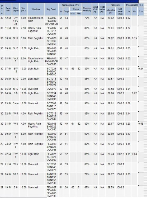
-
Upstate/Eastern New York
DeltaT13 replied to BuffaloWeather's topic in Upstate New York/Pennsylvania
Not disagreeing there won't be some big numbers by Friday, but KBUF is only showing 1.17 as of 12 noon. Where are you pulling those numbers from? -
Upstate/Eastern New York
DeltaT13 replied to BuffaloWeather's topic in Upstate New York/Pennsylvania
It’s because the total precip output maps are notoriously off by a factor of 2 or even 3x. We all know this from the clown maps during all winter storms. -
Upstate/Eastern New York
DeltaT13 replied to BuffaloWeather's topic in Upstate New York/Pennsylvania
They should be excited because it’s cool but likely a non event from the standpoint of any sort of damage or concern. If we half those totals so they are realistic, 2-3 inches of rain in 24-36 hours after weeks of below normal rainfall is beneficial and likely easily absorbed. -
Upstate NY Banter and General Discussion..
DeltaT13 replied to wolfie09's topic in Upstate New York/Pennsylvania
These things have been around forever. Takes very special circumstances to be harmed by them though. A few dozen people die from them each year but it’s almost always from swimming in very warm somewhat stagnant water. https://www.google.com/amp/s/www.nydailynews.com/news/national/boy-contracts-rare-brain-eating-amoeba-article-1.1426134%3foutputType=amp This was a particularly sad one https://www.google.com/amp/s/www.cbsnews.com/amp/news/cdc-brain-eating-amoeba-found-at-whitewater-center-after-teens-death-lauren-seitz/ Having them in the water system has happened before in the south and was Identified when people using Neti pots and didn’t boil the water first died from them. You have to ram them up your nose in large numbers to get sick from them, so it’s not an immediate threat to most but definitely concerning never the less. https://www.pharmacist.com/article/brain-eating-amoeba-death-highlights-importance-safe-neti-pot-use It’s made me think twice before jumping into a freshwater pond. Thankfully they haven’t been reported in Upstate NY -
Upstate/Eastern New York
DeltaT13 replied to BuffaloWeather's topic in Upstate New York/Pennsylvania
Couple of the recent runs showing a real nice high wind event next week (). Could get a little dodgey with all the trees still holding full foliage. This is also the reason for the delayed cold push. That storm blows up and retrogrades back West in the recent models! -
Upstate/Eastern New York
DeltaT13 replied to BuffaloWeather's topic in Upstate New York/Pennsylvania
Its definitely early but the peaks above 4000ft see snow in every month except July and August nearly every year or every other year. Wild stuff up in the high peaks region! -
Upstate/Eastern New York
DeltaT13 replied to BuffaloWeather's topic in Upstate New York/Pennsylvania
I've seen graupel the first week of October a couple times in the last 20 years. Accumulating snow, and feet of accumulating snow is a whole different story (and unlikely to ever happen again in our lifetimes IMO). Definitely looks cold and windy though, will be exciting if it comes to fruition. -
Upstate/Eastern New York
DeltaT13 replied to BuffaloWeather's topic in Upstate New York/Pennsylvania
30's are definitely on the rare side for Rochester in September, especially over the last 10 years. Here is a nice chart to illustrate it. Rochester never got below 48 for the entire month of September in 2019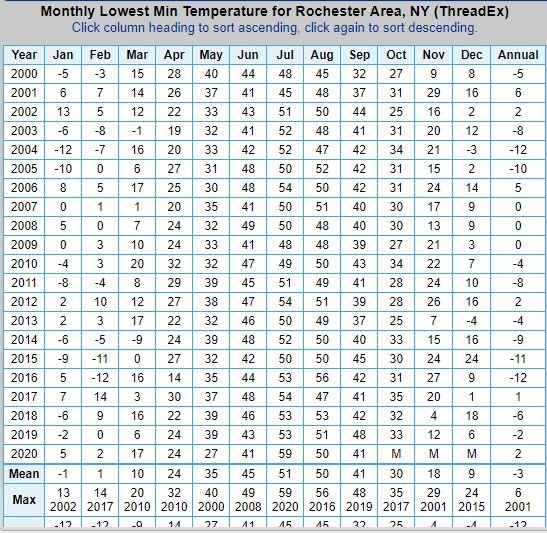
-
Upstate/Eastern New York
DeltaT13 replied to BuffaloWeather's topic in Upstate New York/Pennsylvania
i've been tracking my first frost/freeze date closely for about the last 10 years in Rochester. It usually comes sometime in the 3rd or 4th week of October. This is pretty unusual stuff here, almost 5 weeks ahead of schedule for the lake plain folks. It's certainly going to speed up the garden "tear down" time line down this year. -
Upstate/Eastern New York
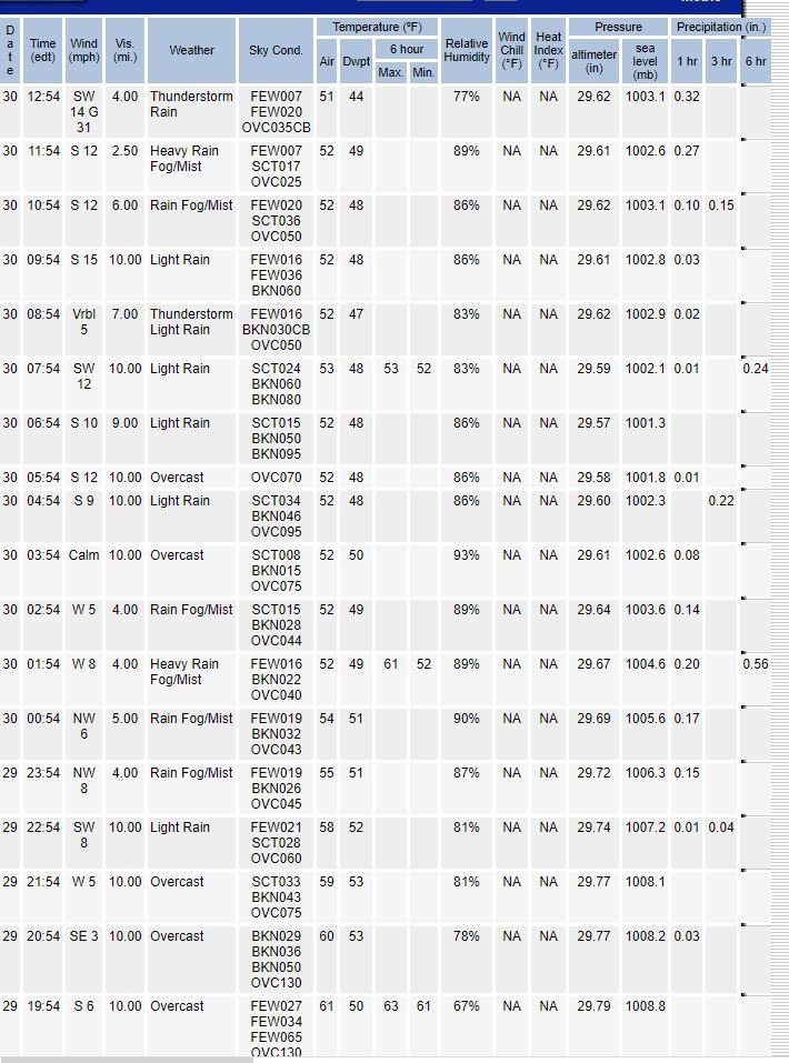
DeltaT13 replied to BuffaloWeather's topic in Upstate New York/Pennsylvania
So the Buffalo thermometer (ASOS) went wacky sometime in mid to late June it would seem. It's a shame we will have corrupted numbers forever in the system. Oh well, guess it doesn't really mean all that much in the big picture. -
Upstate/Eastern New York
DeltaT13 replied to BuffaloWeather's topic in Upstate New York/Pennsylvania
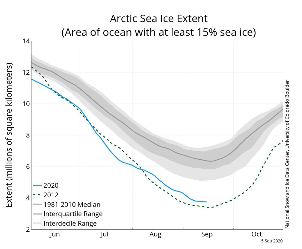
We are right at the average date when Arctic sea ice begins to increase again. Things start to happen fast after this point with much colder nights and fleeting warm days.... Always exciting when we get to this turning point each year. As a side note, its super sad to see that we used to have about 7 million square km of ice on this date, and we now have less than 4 million. A huge ****ing difference....not good...not good at all.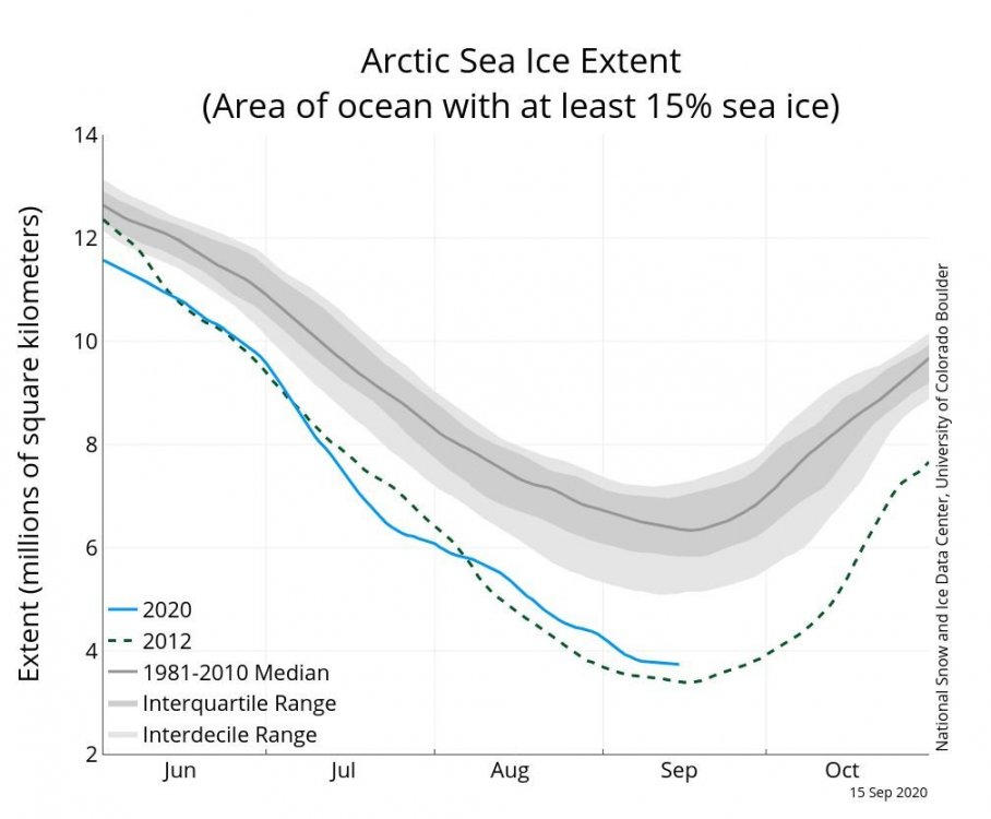
-
Upstate NY Banter and General Discussion..
DeltaT13 replied to wolfie09's topic in Upstate New York/Pennsylvania
In Rochester, some of the gyms are saying that it will be by appointment only. You will reserve a specific block of time for when you can be there. You have to reserve these several days in advance. At least that's how they plan to start back up. We'll see where it goes from there. I've only worked out at home for the past 20 years so no effect on me, but I feel for all my friends who are struggling to find a routine without the gym. I'm hoping things work out for you all. -
Upstate NY Banter and General Discussion..
DeltaT13 replied to wolfie09's topic in Upstate New York/Pennsylvania
Tree loss is always so heartbreaking for me to watch. Those trees across the road were probably 50-70 years old. They will never be fully replaced in anyones lifetime living there now. Also, I always picture Derechos as having one very strong push of intense winds followed by lesser gusts. I'm completely amazed to see that this storm had many rounds of severe winds over a 30 minute period. I don't even understand how that happens in a storm like this. I always say I want strong storms, but thats a hard no for something like that. Just devastating... -
Upstate NY Banter and General Discussion..
DeltaT13 replied to wolfie09's topic in Upstate New York/Pennsylvania
If the whole country wasnt in such disarray, the Derecho event would be getting a lot more attention. Probably one of the most powerful derechos in our lifetime to ever hit the US. Iowa needs federal assistance big time. https://littlevillagemag.com/caught-in-the-storm-in-cedar-rapids-brian-johannessen/ -
Upstate NY Banter and General Discussion..
DeltaT13 replied to wolfie09's topic in Upstate New York/Pennsylvania
Doesn’t get much more real than this. Absolutely fierce looking storms/derecho and they are still getting organized!
-
Upstate NY Banter and General Discussion..
DeltaT13 replied to wolfie09's topic in Upstate New York/Pennsylvania
Well what if all the private mail delivery places went under and folded? Seems like it would be wise to have a backup system in place as mail delivery is about as critical as it gets. -
Upstate NY Banter and General Discussion..
DeltaT13 replied to wolfie09's topic in Upstate New York/Pennsylvania
It should be viewed as a service, just like the Navy, the marines, the red cross, etc etc. Why do we expect them or even care if they turn a profit? Our roads and sewer systems don't make any money, but we sure as hell need them and use them. It's time to stop pretending the post office is a business and treat it like the service it is. -
Upstate NY Banter and General Discussion..
DeltaT13 replied to wolfie09's topic in Upstate New York/Pennsylvania
It’s actually up 2,400% since Monday. An 8k investment Monday morning would have been $200,000 if you sold it yesterday at its peak. -
Upstate NY Banter and General Discussion..
DeltaT13 replied to wolfie09's topic in Upstate New York/Pennsylvania
The post office is actually something affected by; and useful during a pandemic. You can throw funding at them forever and I’ll think it’s money well spent -
Upstate NY Banter and General Discussion..
DeltaT13 replied to wolfie09's topic in Upstate New York/Pennsylvania
Didn’t want to imply the dems were innocent. That just happens to be an unsightly budget from the GOP considering the current state of affairs. Millions of people could be evicted because of something completely out of their control. The government has to step up in that situation. Not buy new planes and warships. If there was finally going to be a bill with no extra fat, now is the time to do it. -
Upstate NY Banter and General Discussion..
DeltaT13 replied to wolfie09's topic in Upstate New York/Pennsylvania
There is always some extra bullshit spending but this seems a little more egregious than usual. I can actually tolerate a few million here or there for side programs that may tangentially help out but aren’t directly related to main cause. This however, seems a little absurd. The GOP doesn’t give a **** about us. They just want to further their military agendas and buy votes. -
Upstate NY Banter and General Discussion..
DeltaT13 replied to wolfie09's topic in Upstate New York/Pennsylvania
Don’t forget this critical part of the new COVID19 bill.... **eye roll**