DeltaT13
-
Posts
3,006 -
Joined
-
Last visited
Content Type
Profiles
Blogs
Forums
American Weather
Media Demo
Store
Gallery
Everything posted by DeltaT13
-

Upstate NY Banter and General Discussion..
DeltaT13 replied to wolfie09's topic in Upstate New York/Pennsylvania
I actually recall almost no fallout from the spring breakers. Tens of thousands of people were out there, I saw very little evidence of any hot spots related to spring breakers. As I’ve stated many times. There is no safer place than a beach. Parks and beaches should be open. -
Upstate NY Banter and General Discussion..
DeltaT13 replied to wolfie09's topic in Upstate New York/Pennsylvania
I think supplies, experience, PPE, and possibly a treatment will be in stock by Fall. COVID-19 is a reality now. Mankind is going to work exceedingly hard at this problem. There will be more ventilators, masks, hospital beds, etc in this country than in any time before. We will learn to coexist and deal with this bastard, it just takes some time. It's only been a few months... -
Upstate NY Banter and General Discussion..
DeltaT13 replied to wolfie09's topic in Upstate New York/Pennsylvania
Every single summer festival has been canceled in Rochester through September and we are doing better than buffalo. I’m shocked they haven’t canceled all those things already. -
Upstate NY Banter and General Discussion..
DeltaT13 replied to wolfie09's topic in Upstate New York/Pennsylvania
Don't look at the consumer to jump start the economy this summer. Just like in 2008, when the future is murky, we hoard cash, pay off bills, and stop discretionary spending. Going to be a long time until we crawl out of this hole. The good news is that there is going to be a whole ton of cash bottled up in the system that will eventually come out as the depression wanes. In the meantime, hold on to your butts. I'm saving cash like crazy. My job is not safe beyond 18 months. https://www.cnn.com/2020/05/12/investing/jobs-coronavirus-consumer-spending-debt/index.html -
Upstate NY Banter and General Discussion..
DeltaT13 replied to wolfie09's topic in Upstate New York/Pennsylvania
Yeah, I don't like getting personal either. This forum has been an amazing place to discuss weather over the years and we all bring our own knowledge and flavor. It would definitely be a lot less fun and more lonely tracking storms without all of you. -
Upstate NY Banter and General Discussion..
DeltaT13 replied to wolfie09's topic in Upstate New York/Pennsylvania
I was definitely wrong about the cost. Still thought it was a little narcissistic to have his name on there. We paid for those checks, thats the taxpayers money. -
Upstate NY Banter and General Discussion..
DeltaT13 replied to wolfie09's topic in Upstate New York/Pennsylvania
Glad to see we agree on the tweets. He tweeted 125 times yesterday. Or once every 7 minutes for 16 hours straight. -
Upstate NY Banter and General Discussion..
DeltaT13 replied to wolfie09's topic in Upstate New York/Pennsylvania
Trump supporters seem to enjoy trolling the Left. They will defend him even when every bone in their body knows the thing he said was completely ****ed up or stupid. It's exhausting. Why can't they just say, "Boy that was stupid once in awhile". You can still like him, but the 100% all encompassing defense is phony and played out at this point. -
Upstate NY Banter and General Discussion..
DeltaT13 replied to wolfie09's topic in Upstate New York/Pennsylvania
I called you a good Shill. Thats just a factual statement. Not an insult. -
Upstate NY Banter and General Discussion..
DeltaT13 replied to wolfie09's topic in Upstate New York/Pennsylvania
I'm a fan of socialism. I think universal income is absolutely inevitable. Bailouts are fine are when the alternative is the economic collapse. I just find it amazing that Trump Supporters are notoriously anti socialism but certainly have their hands out there right now. Amazing how that works. Side Note - Obamas bailout is Bushs. We all know that. We all know the meltdown happened in Fall 08' and was built on the previous 10 years of bad banking. -
Upstate NY Banter and General Discussion..
DeltaT13 replied to wolfie09's topic in Upstate New York/Pennsylvania
To be honest, I rarely go there, but Trump supporters just enrage me more everyday. He's the worst human ever. Did you see how he treated that Asian reporter yesterday, its beyond insane at this point? Also, the irony here is AMAZING! Trump is the king of insults and name calling...and one of the dumbest, least factual, least scientific people in modern history. The cognitive dissonance with your post is off the charts -
Upstate NY Banter and General Discussion..
DeltaT13 replied to wolfie09's topic in Upstate New York/Pennsylvania
If these checks aren't socialism I don't know what is. You're ridiculous. -
Upstate NY Banter and General Discussion..
DeltaT13 replied to wolfie09's topic in Upstate New York/Pennsylvania
Such a loyal shill you are. lolz -
Upstate NY Banter and General Discussion..
DeltaT13 replied to wolfie09's topic in Upstate New York/Pennsylvania
You actually make a good point. The toner for millions of reprinted checks isnt zero. -
Upstate NY Banter and General Discussion..
DeltaT13 replied to wolfie09's topic in Upstate New York/Pennsylvania
I had read (possibly erroneously) that changing print templates was extremely costly at the time because they had to rework millions of checks that were already through the system. I'm guessing those checks don't roll off a Xerox printer using Word in some guys office. There are massive amounts of man hours and money put into every aspect of rolling out those checks, but way to oversimplify it though. The bottomline is that Trump wanted his name on the Check, so how is this solely a democratic issue in your eyes? Trump loves handing out socialist checks and doesnt even realize it. -
Upstate NY Banter and General Discussion..
DeltaT13 replied to wolfie09's topic in Upstate New York/Pennsylvania
Don't forget who spent millions of additional dollars to have his stupid name put on the stimulus checks!! Dumbass Donny. The Republicans own this mess and always will. (yes I know congress holds the purse strings) -
Upstate NY Banter and General Discussion..
DeltaT13 replied to wolfie09's topic in Upstate New York/Pennsylvania
The moral scruples on this decision are crazy. I go back and forth every day. Your scenario is the "kill the old people as fast as the hospitals can procees them" approach which may or may not be the right idea. It all depends on whether or not a treatment can be devised to significantly lower the death rate for the elderly. Some days i think unfortunately that might be the right choice. The next day I think about older friends and relatives and feel like a monster for thinking that way. It's just a whole lot of bad options. -
Upstate NY Banter and General Discussion..
DeltaT13 replied to wolfie09's topic in Upstate New York/Pennsylvania
The current situation does a great job highlighting just how lousy the pay and raises are for the service and GIG industry. The safer higher paying jobs got 8% raises since last year (the only jobs left to measure against right now). Ask all those GIG employees how big their raise was in the last year (excluding the current COVID crisis). Probably closer to 1% if anything at all. It's a brutal system in this country. -
Upstate NY Banter and General Discussion..
DeltaT13 replied to wolfie09's topic in Upstate New York/Pennsylvania
One of buffalos most exciting years erased by covid. Such a Billsy way to lose out. -
Upstate NY Banter and General Discussion..
DeltaT13 replied to wolfie09's topic in Upstate New York/Pennsylvania
Hawaii has a 14 day stay in your hotel quarantine -
Upstate NY Banter and General Discussion..
DeltaT13 replied to wolfie09's topic in Upstate New York/Pennsylvania
This virus is still very new. Eventually there will be treatments, a vaccine, and herd immunity. There is no reason to think this will persist forever without a solution. The world is going to be all out of whack for a good year or so but things will settle out. When people get sick years from now they’ll say oh yeah I had covid a few weeks back just like we talk about strep throat, the flu, noro virus, colds, sinus infections. It will just be another germ that you occasionally get. -
Upstate NY Banter and General Discussion..
DeltaT13 replied to wolfie09's topic in Upstate New York/Pennsylvania
My evidence for us not leading in science and innovation is a bit anecdotal, but any person that says "Let's bring back the coal jobs" obviously isnt on the cutting edge of science and energy technologies. Where to start...... Solar and wind energy has been taxed and defunded. The EPA has been outright decimated, those numbers are out there for everyone to look up. Trump advised the NNSA two years ago to begin shutting down the nation laboratories that were studying fusion science (even though most of it has to do with nuclear weapons testing). He has repeatedly called climate change a hoax (which I'm not sure how that isnt insulting to scientists and generally anti science). Took us out of the Paris Climate Agreement which is just an awesome agreement from a pollution standpoint regardless if you believe in climate change or not. The list goes on and on. Oh yeah, his VP also thinks the earth is 5000 years old. I dunno man, doesnt take a genius to assume that we have taken a few steps back in regards to science over the past few years. I've experienced it personally with budget cuts threatening my job several times. https://thehill.com/policy/energy-environment/482352-trump-budget-slashes-funding-for-epa-environmental-programs A small excerpt if you don't want to read. "President Trump’s proposed budget for fiscal 2021 calls for significant reductions to environmental programs at federal agencies, including a 26 percent cut to the Environmental Protection Agency (EPA). Trump’s budget would eliminate 50 EPA programs and impose massive cuts to research and development, while also nixing money for the Energy Star rating system. The Energy Star program, which measures the efficiency of electronics and appliances, would instead rely on businesses to pay a fee to participate in the program. The proposed spending reductions mark the latest effort by the administration to chip away at government agencies focused on science, the environment and public lands. The White House budget request would reduce spending at the Energy Department by 8 percent and cut 16 percent from the Department of the Interior's budget." Thankfully congress usually says no to these outrageous proposals but to say that the Trump administration has advanced science is an outright lie. You can like Trump all you want, but agree that there is a loud anti science rhetoric in the current admin. -
Upstate NY Banter and General Discussion..
DeltaT13 replied to wolfie09's topic in Upstate New York/Pennsylvania
I’m not condoning China in any way, just saying it’s not all bad. Americans are absolutely addicted to cheap stuff and China makes that happen. All the rest of the social issues I’m right there with you. But I also think China is in for some huge challenges going forward. They have an enormous and potentially hard to control population, that has nowhere near enough young people to support it (one child law will be there downfall). A communist regime that will always be fighting off the potential of uprising (see all of history, and also recently Hong Kong), automation Issues, food shortages, pollution woes, and apparently deadly diseases. China isn’t just skipping along this road of life. I thought the US was absolutely on a perfect trajectory coming into 2016 and poised for continued world leadership and dominance. We were leaders of science and innovation, working on universal healthcare, had a focus on the environment and conservation, funding for all renewables and energy sources, phasing out fossil fuels. Times were we’re looking good. We definitely let China back into the race with this current admin. Such a shame. It will be really hard to recover after 4 more years of science crushing nonsense. What a shame. -
Upstate NY Banter and General Discussion..
DeltaT13 replied to wolfie09's topic in Upstate New York/Pennsylvania
I look at china with a far less cynical eye. China in my opinion is in integral part in why America is as strong as it is now. They "took" all of the low skill, low pay jobs, that Americans didnt/shouldnt want or even need (remember the unemployment rate was just recently sub 4%). They do these jobs at pay rates that would be literally impossible to sustain in American dollars and they give us incredibly cheap products allowing us to devour a massive amount of useful products for dirt cheap prices. Furthermore, most of these jobs are and will be automated going forward. The US in the meantime is finding alternative jobs and innovating while China does all the "grunt work". Once automation really rolls through, China will be well behind and face massive job shortages while the US will be cruising along and past the blue collar manufacturing phase of our economic growth. -
Upstate NY Banter and General Discussion..
DeltaT13 replied to wolfie09's topic in Upstate New York/Pennsylvania
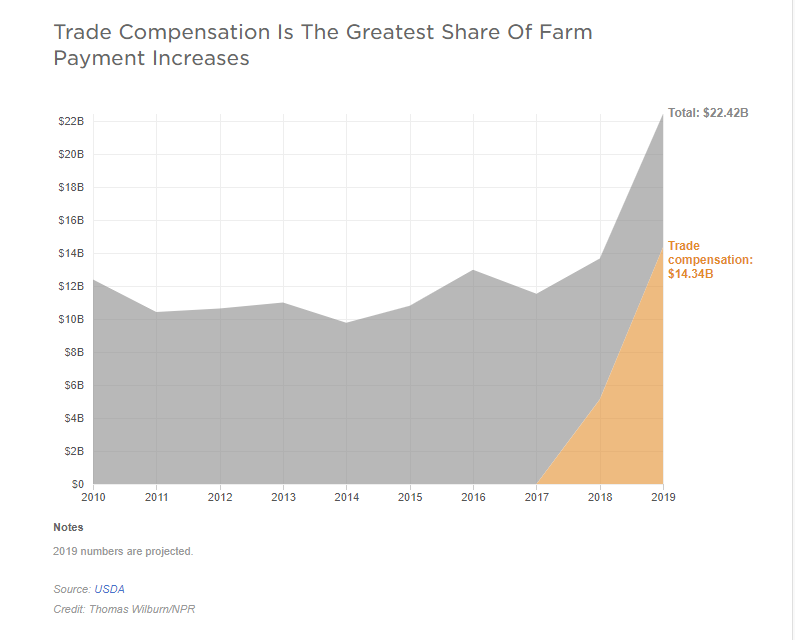
I can't take all this WINNING. LOLz.... just insane that people buy into Trumps bullshit. Worst. Businessman. Ever. https://www.npr.org/sections/thesalt/2019/12/31/790261705/farmers-got-billions-from-taxpayers-in-2019-and-hardly-anyone-objected