
SleetStormNJ
-
Posts
764 -
Joined
-
Last visited
Content Type
Profiles
Blogs
Forums
American Weather
Media Demo
Store
Gallery
Everything posted by SleetStormNJ
-
Cue the obligatory Kylo Ren "More" GIF. Although N&W may want to hold it until later in the week with the model runs.
-
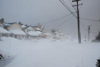
I would think so - I'm in Cranford/Kenilworth area and we got pretty uniform 11-12 inches in reports from folks around Union County (Cranford, Kenilworth, Roselle Park, Mountainside, Westfield). I measured 5 times yesterday for total of 11.9 in Kenilworth, last measurement around 1030pm.
-
Extreme Cold, Snow & Sleet: SECS 1/24 - 1/26
SleetStormNJ replied to TriPol's topic in New York City Metro
We ride the lightning here in these types of setups - it's exciting - but folks have to stop see-sawing with each individual model and buying it - I mean we're talking like overreactions of about a 10-15m swing of a mix line and a faux snowmap showing 1-2 inch perturbations here. -
Extreme Cold, Snow & Sleet: SECS 1/24 - 1/26
SleetStormNJ replied to TriPol's topic in New York City Metro
LOL - it's treating western Long Island as if it is an active volcanic mountain range. -
Extreme Cold, Snow & Sleet: SECS 1/24 - 1/26
SleetStormNJ replied to TriPol's topic in New York City Metro
It will be a Sleet Line Tango tomorrow folks! -
Extreme Cold, Snow & Sleet: SECS 1/24 - 1/26
SleetStormNJ replied to TriPol's topic in New York City Metro
Haha. This is like a Super Bowl for me. There will be thousands of texts about the pinging/mix line on KEWR radar to family and friends Sunday afternoon/evening. -
Extreme Cold, Snow & Sleet: SECS 1/24 - 1/26
SleetStormNJ replied to TriPol's topic in New York City Metro
Tip of cap to Sacrus for posting the overlay comparisons of the precip/accum maps. Again verbatim - very impactful storm for the metro area coming into agreement. -
Extreme Cold, Snow & Sleet: SECS 1/24 - 1/26
SleetStormNJ replied to TriPol's topic in New York City Metro
AI Euro and GEFS were almost identical btw. Aside from the fretting of snowmaps or other warm-nose evolution, the scale of the system and moisture being worked with is impressive. -
Extreme Cold, Snow & Sleet: SECS 1/24 - 1/26
SleetStormNJ replied to TriPol's topic in New York City Metro
Folks getting little too caught in model runs (NAM at end of cycle), verbatim the suggestion from models is this a real blitz of a SWFE - should not be ignored - thump of snow with heavy sleet is nothing to be ignored in our area, even if "just" 6-12 range. Interesting to see some of the model variations right now with the aspect of the mid-level lows and the coastal (this is gonna be the watch the next 2-3 model runs). -
Be patient young Jedi.
-
January 28/29 Blizzard Observations/Discussion/Nowcasting
SleetStormNJ replied to Northof78's topic in New York City Metro
Yup. Enough for a jebwalk or two. We will get “ours” again eventually. -
January 28/29 Blizzard Observations/Discussion/Nowcasting
SleetStormNJ replied to Northof78's topic in New York City Metro
Yup. Models honed in on a sharp cut off and wall last 24-36 hours before onset. Nice prolonged light to moderate snow event with some wind for us nonetheless but this one had looks of eastern areas special written on it for a few days. We will have to wait and be patient for our next MECS/HECS here. -
January 28/29 Blizzard Observations/Discussion/Nowcasting
SleetStormNJ replied to Northof78's topic in New York City Metro
HECS up there and on Cape/E. LI. Up there with some other big ones now for sure and amazing how many just in last 20-25 years. -
January 28/29 Blizzard Observations/Discussion/Nowcasting
SleetStormNJ replied to Northof78's topic in New York City Metro
Enjoy it man! Memorable one for you guys out there. -
January 28/29 Blizzard Observations/Discussion/Nowcasting
SleetStormNJ replied to Northof78's topic in New York City Metro
Yup. Weak sauce up here in Union County. Maybe six or seven inches. This was a significant event but nothing more here in Central/Northern Jersey. Glad for LI and Coastal crew. Hope we get something else big over next six weeks for those that missed out. -
Yes. Will be interesting to see where the western band sits. Usually delivers goods with fronto/forcing and better ratios away from coast. Can't read snowmaps verbatim.
-
I like where you sit in this setup. You've done well on some of these tight gradient coastals over the years.
-
Have to keep in mind the banding features. We won't know the exact orientation/pivot until it's happening. The mesoscale mauler of Feb 2006 comes to mind, along with Boxing Day and March '18.
-
Have to avoid getting sucked into run to run windshield wiper effect. We need to start measuring model pinpoints and actual observations. No bets are off the table. Seen so many big storms in past with surprises in terms of track, banding, gravity wave enhancement, dry-slots, winds. One thing impressive regardless is the modeling in almost all cases are projecting some serious sustained winds and gusts for coastal areas - NJ/LI and out to RI/Cape.
-
Definitely either way. This is going to be a tightrope walk and watch situation as these coastals often are. Boxing Day and Jan 2015 come to mind quite a bit, but even some of the big ones we had in March the last five years or so ended up being a nowcast situation where the bands set up and pivoShow Repliest. A 25-30 mile difference or edge west or east makes big differences.
-
Looks like a dual paintbrush/model hack job by Ant. Goodness.
-
For good chunk of NJ, Ida (even if remnants) will go up right with Sandy and Floyd in top 3 of impacts over last 30 years (Isaias and Irene not far behind). Sadly, these events are coming closer together in time and with dramatic broader and intensity level impacts (wind or rain/flood, surge) respectively.
-
Yup. I'm in Kenilworth right nearby and I lucked out, but all towns around me have spots where houses took on major water in basement (either creek, culvert, or just simply stormwater backup). Can hear the choppers surveying impacts.
-
Parts of CT look to be in deluge now.
-
Parts of Union County NJ reporting around 6-8 inches already (Cranford, Roselle, Roselle Park areas).


