
SleetStormNJ
-
Posts
764 -
Joined
-
Last visited
Content Type
Profiles
Blogs
Forums
American Weather
Media Demo
Store
Gallery
Everything posted by SleetStormNJ
-
Feb 18-19 long duration manageable snow and ice event
SleetStormNJ replied to wdrag's topic in New York City Metro
We've had some volatile swings in late February into March over past 10 years (last year notwithstanding, but 2017 had some cold spells and a significant storm, 2018 a couple, and a bunch in 2019). Even back into 2013-2014 and 2014-2015 had some March events too. -
Feb 18-19 long duration manageable snow and ice event
SleetStormNJ replied to wdrag's topic in New York City Metro
True Wintry Mix storm of decent duration on EURO. Prolonged snow with a bit of a thump for few hours with sleet mix and then some FRZ rain and light rain at end for some locales. -
Feb 18-19 long duration manageable snow and ice event
SleetStormNJ replied to wdrag's topic in New York City Metro
Yup. Will be key to hone in late tomorrow and Wednesday as it gets closer. -
Feb 18-19 long duration manageable snow and ice event
SleetStormNJ replied to wdrag's topic in New York City Metro
Event is still a good 72 plus hours away. Too much can slip in either direction and ingredients (PV, High), low placement and track have to be figured out over next 48 hours. That said, I still like this event for potential significance/impact. Not every storm can be a 1-2 foot behemoth. I've seen significant events surprise/wreak havoc because they get "downplayed". -
Obs and nowcast Super Bowl Sunday 4A-6P Feb 7, 2021
SleetStormNJ replied to wdrag's topic in New York City Metro
Great job by NWS. Kudos and thanks to them. They pretty much nailed it. -
When I said last weekend we were probably due in next 10-15 years for an 09-10 DC or Boston’s historic winter a few years back I didn’t expect to possibly see it over an entire month not within 15 days potentially.
-
2-7-21 Sunday 8-12 hour nor'easter snowstorm roughly 5A-5P
SleetStormNJ replied to wdrag's topic in New York City Metro
GFS has been somewhat consistently so far this winter too far SE with the precip/banding on last few storms. Even in last storm for NJ, there was a good 30-40 mile difference to NW of best/max banding. -
2-7-21 Sunday 8-12 hour nor'easter snowstorm roughly 5A-5P
SleetStormNJ replied to wdrag's topic in New York City Metro
Coast does well it seems - dependent on thermal profiles. -
2-7-21 Sunday 8-12 hour nor'easter snowstorm roughly 5A-5P
SleetStormNJ replied to wdrag's topic in New York City Metro
Yep. Showing up as impressive with moisture feed/jet. Also think the PNA help is here with this at moment as modeled. -
2-7-21 Sunday 8-12 hour nor'easter snowstorm roughly 5A-5P
SleetStormNJ replied to wdrag's topic in New York City Metro
Significant western lean on the GEFS cluster there. -
2-7-21 Sunday 8-12 hour nor'easter snowstorm roughly 5A-5P
SleetStormNJ replied to wdrag's topic in New York City Metro
Verbatim - wallops some of the areas that kind of got fringed on this storm/gives nice event to ENJ/NE NJ into LI/CT/MASS. Early but QPF estimates on this run about 1.1-1.4 for areas. Quick mover (about 12 hours). -
2-7-21 Sunday 8-12 hour nor'easter snowstorm roughly 5A-5P
SleetStormNJ replied to wdrag's topic in New York City Metro
Whoops - 2009-2010 - that's right. We did well in both those winters too - but DC cashed in big on the Dec '09 and then again in the 1st week of February and even got in on action a bit in the one we finally got hit with a week later. -
2-7-21 Sunday 8-12 hour nor'easter snowstorm roughly 5A-5P
SleetStormNJ replied to wdrag's topic in New York City Metro
Never say never for a couple big ones in single winter/timeframe. North mid-atlantic is kind of overdue for a DC (2010-2011) or Boston (back in mid 2010s (can't remember if 2013-2014 or 2014-15) winter...... February looks promising for a few threats over coming 2-3 weeks. -
Some places in Union County by me already have 16 inches...........We'll easily hit/break over 20".
-
Not far from you and easily have 16-17 inches. I think 12-16 more will be tough but can see an easy 6-10 more.
-
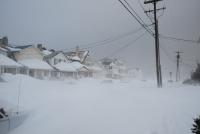
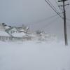
History in the making.........again. Wow. Heavy Snow, Wind, Visibility close to nil. Kenilworth, NJ. 26 degrees. Approximately 9-10 inches on ground (measurement avg came out to about 9.7-9.8).
-
NAM is ridiculous - if it verifies, thats an easy 24-32 jackpot zone for EPA/NC/N-NJ, SNY/HV into portions of NYC/LI and SW CT.
- 2,426 replies
-
- 1
-

-
- heavy snow
- ice pellets
- (and 3 more)
-
Going to be some intermittent snow bands in our area throughout until evening. More moderate snow won't come until late overnight/early morning hours tomorrow and then the show really comes during day into afternoon/evening. 20 degrees in Kenilworth, NJ currently. Can feel storm coming (air and can feel it in my bones!)
-
I'm impressed with the continued moisture transport/frontogenesis features - somebody is going to get clobbered.
-
I will say a lot of our big ones that were Miller Bs tend to have a signature of consistent/longer snow like this. (Corrected - Miller Bs). Remember Jan 2005 as an example for the North Jersey crowd.
-
That's got to be a Tony dupe, right?
-
Well the NAM appears to be running these days out of his basement, so.....
- 2,426 replies
-
- 2
-
-

-
- heavy snow
- ice pellets
- (and 3 more)
-
Gorgeous. It literally snows in northern NJ like 36 hrs straight.
-
NAM is kind of the only model though that shows the drop in PA and favors later coastal CCB development. Have to watch that into runs of other models and tomorrow’s midday cycles.