Typhoon Tip
-
Posts
44,789 -
Joined
-
Last visited
Content Type
Profiles
Blogs
Forums
American Weather
Media Demo
Store
Gallery
Everything posted by Typhoon Tip
-
yeah...it's interesting to see 2019 be within decimals of those floor values when there's an average bottom date of Sept -16 among those other years, and we're only on August 21
-
This is gonna be close ...
-
Occasional Thoughts on Climate Change
Typhoon Tip replied to donsutherland1's topic in Climate Change
There are solutions to the entire power-grid aspect of this that are completely obscured(ing) from masses. Partially by design ... partially by habit. There are "exotic" technologies in the private sector that no on even knows about ...buried, quietly... be it Trumpian morality and ethics, ...or just the hand-me-down dogmas of generational traditionalism within people's ways of life - basically ...culturally suppressed. But because of the suppression ... oblivion, and what probably should be more obvious has to now be 'out of the box thinking.' It's not that it is out of the box, ...it's just that we've been conditioned by a combination of convenience and apathy not to consider. It is possible to sequester electrical charge straight out of the ambient atmosphere. Yup... free energy. But therein is the problem ... that poke in the craw of the sociopath, "free" ... "hmmm... shit. That means I don't get to con Humanity into dependency on Oil and other pernicious means of energy extraction ... wantonly ignoring morality along the way in reaching the goals of my quarterly reports ...! God damn it..." It kind of reminds me of the "Mosquito Coast" Think about it - even you are not a physicist ...you should be able to intuit the plausibility. There can be a way to draw power directly from any gaseous volume that contains energy (thermal resonance) greater than absolute zero - ... we're living on a planet where there is just such a volume, and guess what... it's got so much thermal energy in the free static air that any quantization would be so large a number, it would escape all effective meaning... And, these devices have been invented... It's called the thermoelectric effect ...basically, it's theoretically known spanning multiple generations... where it is possible to convert temperature differences, directly to electric voltage ... ( and vice versa...which could be harnessed in home heating and cooling without too much imagination ... etct) And it's all done through the physics of thermocoupling ... ...etc..etc.. But nope - Humans can't seem to evolve away from that pesky evolutionary advantage that no one would ever concede was necessary along the way: GREED... Hoarding and me-firstitude favors the individual. See...the way that works ( crude model): when the collective cooperation spirit of the community is about to cause the extinction of the village that hoarder survives his/her genes into the next generation - greed lives... It is why greed is actually a core instinct along with all others, in the genetic make-up of humans. It's sneaky, stealthy ...furtive presence in all dealings has piggybacked along with cooperation instinct along the evolutionary tract. Any moral ( morals can be bad or good by the way...) we can learn to avoid them? ...suppress is more like it... But, greed is no longer necessary in times of surplus and opulence ...and at present state of evolution, human ingenuity has long outfoxed the basic ecological model of survival by provisions therein. We produce our own provisions...is surplus. Perhaps if the asteroid does strike one day, or the Carrington Event shuts this thing done and there's an immediate jolt back to primal living ...greed will have it's stealthy place again... But until that happens... it's an instinct that hasn't turned off...but is causing all this... And is hugely exposed. Because it's morality is now competing with the morality and ethics of that which would provided a greener vision for the world. That's really all it is... that simple. Humans can't do anything truly altruistic. Nope. They have to invent a illusory system of value, Economics... ( which sorry for the soulless among us who are so bought in they're oblivious to reality... money has no intrinsic value outside the parlance and tragic comedy of Human affairs - we all merely agree on it's value... ) and then hold individual's ability to survive for ransom by making profit off that dependency -
Yeah that product I posted is the MASIE ... or the augmented IMS ... hints at that in the lower right text block ...which for some reason had previous escaped my attention. Heh... anyway I found a different site that describes similarly when searching this shit - anyway, I think these curves have to converge at some point - thing is... we're so close to shared curve space that's probably splitting hairs at the moment... 2012 vs 2019 I mean
-
Okay ... .this is just quick and dirty Web goop but... IMS is being used by the National Snow and Ice Date Center ... IMS Daily Northern Hemisphere Snow and Ice Analysis at 1 km, 4 km, and 24 km Resolutions, Version 1. This data set provides maps of snow cover and sea ice for the Northern Hemisphere from February 1997 to the present from the National Ice Center's Interactive Multisensor Snow and Ice Mapping System (IMS). That's what's confusing ... if we say "...2nd lower behind NSIDC" ( which I'm not trying to refute...) but this statement above says they are using the same IMS tech, and said tech is showing 2019 has been lower than 2012 the whole way... that's a discrepancy.
-
I have a question - which may be fairly 'duh' but since I haven't been by those other sources ... Are those more comprehensive than "sea ice only" ? That IMS product is sea ice only ... And also, just fyi ... the IMS product comes from NSIDC - we may be able to put the pieces together here on why the disparity. It's gotta just be some dumb product thing I'm not seeing shit
-
2019 ENSO
Typhoon Tip replied to AfewUniversesBelowNormal's topic in Weather Forecasting and Discussion
I don't doubt there is/was relevant science and/or postulate content that predates the shenanigans that go in here I mean ..it's a public forum ... to which a social media outlet certainly qualifies, and folks rarely cite their sources, anyway. That said ... this came up back in Eastern days... from which this site really owes it's heredity of users ... (initially anyway ...that's probably obscured by now), but unfortunately, content didn't follow. Also, I frankly wouldn't put it past anyone in the general ambit of research ... regardless of affiliation and rank, elsewhere ...to poach ideas from dialectical free-for-all sources ( like the Web when it's not degrading into vitriol ) and then run with it using the wherewithal they have at their disposal. Much of that wouldn't even be malfeasance ... not the point. If I'm in a conversation with someone and it triggers a thought progression...and I science it and make discoveries... It's just where the 'idea zygote' took place. But like I said...like mindful quorums and consortia and who-knows-what intelligentsia ... they will tend to converge on similar ideas at the same time - this has taken place throughout human history. I probably shouldn't have mentioned it as an afterthought .. . -
Occasional Thoughts on Climate Change
Typhoon Tip replied to donsutherland1's topic in Climate Change
Firstly ... I like the opening thought here ... There are indeed vying forces ...some more dominant than others, in every multiplex system of Nature - to which the governing atmosphere/climate forces certainly fall into this give and take. Secondly ... you know it's funny - this business about "fossil" fuels... It took this planet some 100's of millions of years to sequester carbon out of the global biota ...and inter it all into these VOC chemistries ... then, Humanity comes along. With its ingenuity ( which has clearly out-paced any pragmatic checks and balances in the evolutionary sense of it...) we've managed ( ..if left to our own devices ) to liberate all of it back to environment in unbounded form in just 1,000 years. 100s of millions 1,000 The idea that there is anyone at all who would have the audacity to even try and ask anyone to negate ramification - ...that's incredible. I suppose it is possible ( tho proven not the case on Earth...) to find a system somewhere in Nature where you can completely forcibly infuse change without actually witnessing change ... -
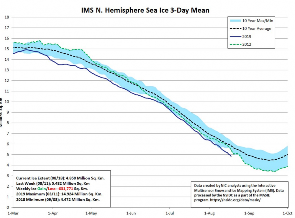
Fwiw - as of two days ago ( 18th ) from IMS: https://www.natice.noaa.gov/ims/
-
2019 ENSO
Typhoon Tip replied to AfewUniversesBelowNormal's topic in Weather Forecasting and Discussion
Really ... Not looking for credit per se ... but, I haven't heard about the gradient hypothesis from anyone other than the person who proposed it five years ago ... and has been heavier about it over the last two. Now, it's owned by someone else - Heh... I suppose - fire was quasi implemented as a formal tool in human history at the same time every, too, so ...it's possible more than one person had the exact same to the letter ...inference regarding climate variations and large scale circulation forcing - -
ISM is lagging by date ... as of last check... They seem to update that about every 10 days...and it's for the previous week, too...so by the time it's published it's an addition three or so days beyond that week... Aug 11 ... That's what I've seen from them since July. They'll probably release an analysis for the 18th in about two days... oy - As far as the subject crap - nah dude. More like concern... I don't really care if people want/need/do/or don't have biases... I just want to know that what I'm reading isn't that - which admittedly is probably not going to happen in a public social media source. word. Just so we're clear. In order to make that assessment... I may sound I like I care about specific posting behavior ... but that's not it. I'm not sure anything you have said should invalidate IMS inclusion - not that you mean to... I think it is at least worth it to vet why their plots vary... interesting. I'm wondering if it's density related.
-
I don't know… It strikes me a bit like people just not wanting a record to be broken I'm sorry it does. Otherwise the IMS plots I supplied would've been part of the discussion all along and looks a bias when potentially valid data is elided. Maybe it's not that way OK…
-
We keep saying this ...than it's not - where are y'all getting your data... I've been utilizing NOAA's IMS ...and admittedly, it has not updated since the 11th ...but there curve was substantially more loss than 2012 as of the 11th ... it'll be interesting to see if that tend trajectory could have down such a drastic 45 deg angular change so abruptly and gone back across the 2012 slope - which is what would need to have taken place according to their products in order for the current 2019 to be less disastrous - Anyway, may be a moot point - the AO is trying to rise in the GEFs ensemble. I don't get to see the Euro EOFs but... should it rise, that may alleviate the ice loss rates - slow it down ...and in fact, if that's true they may be one in the same already... I want to stress though, that there's nothing gained in the longer run by 2019 failing to surpass 2012 - it means nothing.... The longer termed issue with the polar ice cap remains dire... I'm hoping there isn't some coveted like idea that we are coming out of the arctic crisis? ... just sayn'
-
Yeah that IMS chart post just updated as of the 11th and looks nothing like that - interesting
-
Looks like everyone's referring to different data ... The curve I'm looking at ... 2019 has more ice loss than 2012 to date.... not saying the season ends up that way - or even if that date relative measure is correct ... but
-
Free fall... The vector of the current NSIDC graph has now fallen below all curves since 1998 like I ship headed for the open sea -
-
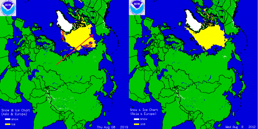
Well...be that as it may, the graphical presentation being perhaps a week behind other sources... The dailies depict illustrations that clearly still put 2019 ahead of 2012 as of August 8 from the same source as that graph. one, it will be interesting to see the graph update... heh.. But two, I've annotated and it's pretty clearly obvious ...if said graph is based upon anything resembling these [crude] cartoons... it's just as likely to update still below the 2012 curve..
-
Do y'all have some access to extra-double, top -secret data that is different than this ...? Cuz just from where I'm sitting... 2012 is getting it's ass handed to it - I dunno.. you tell me. Yeah some 'gap' closure there but t-heh... that integral ain't supporting any kind of angst that we'll have trouble ousting 2012 in this 'race'
-
You know ... not to make light of this ...but it's funny how we are proverbially bargaining with cumulus cloud shadows to prevent ice loss ... heh. But yeah, it's actually true - when we are teetering at the edge of the 2012 comparison...that closing margin does get sensitive to intra-weekly perturbations passing through the the domain. Fascinating actually -
-
thanks
-
Source?
-
Occasional Thoughts on Climate Change
Typhoon Tip replied to donsutherland1's topic in Climate Change
Deniers deny because they can. That simple. If a person is standing on a train track and there is a one-eyed headlight monster roaring and rumbling metallic horn blowin' warnings at them ...they'll be less apt to deny how standing on said tracks would be detriment to their well-being... The problem with Human response to this crisis ...particularly as it relates to the slowness and/or stopping the denying "idiocracy" ... we simply cannot hear, see, touch, smell, or feel AGW or GW or whatever comfortable or uncomfortable euphemism there is that labels what's going on with the planet. When that happens, the denying will stop. But for the interim... it's not in a guy's living room... It's not stopping them from driving to work. Taking their kids to Soccer. Going on that family vacation... sitting around and opening presents on Christmas morning ( if that's your bag...). All there is are dire warnings that attack the ability to engage in all that... A human being... which billions of create this thing we call Humanity ... never react to warnings. They only agree to them in principle. What resonates is pain - it has to register as an inconvenience to the corporeal senses... That's perhaps an evolutionary catch-22 ( as a digression...) but, we have evolved now the ability and ingenuity to improve survival chances ...beyond ecological balance.... Which Terra-forms this world whether we are intending to or not... and...more likely toward a realm that is no longer going to sustain those same advancements. That's the C-2-2 We are capable of these advances... but the capacity to predict and anticipate consequence for action has not kept pace with the powers of ingenuity. In the mean time, it's a nice summer day out there ...and that's the validation for the warnings - good luck. -
Firstly, I'm not sure the social-media community in this particular web destination really IS of the 'wanting/wishing' ilk ... I'll just expand on that a little more... but it was really a 'just in caser' Imho, should 2019 somehow by excruciating number crunching ( less than obviously ) fall short of 2012 ... was it really worth all the effort and writing...and annotated graphs and monitoring and ..well, basically obsession? We are not "making sure that happens" - by plying that effort. I can understand statistical accuracy but I wonder if the real motivation for doing so lurks behind that excuse, because the bigger, longer term consequence of what the world faces is so dire right now that to do so ...could not be any more futile. If it falls short, nothing's different. Why then? The longer vision, we're still f*!&ed folks. As far as that article... There's a lot of complexity that is not really discussed in that... In a general scope and concept it's not "un-clad" exactly ...But, there are ... synergistic effects that are 'emergent properties' and aren't really predictable... More over, those can have secondary ...tertiary spontaneities too... The blocking idea can come from other sources: First, ... extinguishing planetary wave/dispersion into higher altitudes. Think of it as where warm advection plumes go to die. The vagaries of R-wave undulations over time, can create episodes where/when warm fluxes cause/contribute to tropospheric blocking .. These are ephemeral in nature... If they persist ( causally ) it's the underpinning pattern that's supporting it.. The NAO domain is a good teleconnector to exemplify this.. It can fluctuate at intraweekly time scales because of this sort of transient phenomenon... And is why seasonal predictions for that teleconnector - heh... good luck. Second ... blocking anywhere from that can happen in any era. Third, ... it is not abundantly clear that GW would in fact promote more of that to happen, because ... it's all still based upon gradients. Without gradients...no air movement exists at all. From that very fundamental requirement of physics, working together with gravity over a curved surface... without the first initial requirement of changing PV=NRT from one point to another...not of this, in fact, this conversation, can happen.... Why is that important? Beyond the obvious ... the arctic also is said to be differentiating warmer/faster than everywhere else... Is that true in the middle troposphere? If so... than the gradient is not necessary increasing because of GW... but, I suspect it is anyway... The arctic is just trying to catch up ...and in the interim ...we are witnessing extraordinary jet speed anomalies and have been now over the recent decades. Flights between NY and London...also across the expanse of the Pacific have registered historically fast ground-based velocity speeds in that time. This is happening because the warmer equator/sub-tropical latitudes are storing more water vapor ( concomitant with the GW ...) and fiddling with the math ... that is keeping heights slightly elevated; pressing ( as it were) against seasonal nadirs in the winter. Even if they are warming...they are not warming fast enough to compensate for the ambient steepening of that gradient that exists between ~ 35N and the 60 N girdle around the hemisphere. This creates the hurried velocity saturation being observed... Lastly ... folks are forgetting that we are still moving through the 11, 22 and 300 year temporal super-position of the Max(min) solar. Those times have been correlated strongly with -AO tendencies... That makes it incredible difficult to untangle 'how much' of blocking is a result of warming arctic ( as it relates to GW ) - vs how much was destined to take place as this solar expectation has arrived and we transpire through... I suspect like everything...there's shared forcing there... ** The gulf stream stuff and the AMOC - that's a whole 'nother ball of wax. The warming in the previous ... probably going back to the early 1980s is when it really started... has been adding fresh water to the surface of the Atlantic... That's been accelerating particularly in the latter half of that multi-decadal time span. At some critical threshold the specific gravity has changed too much...and the buoyancy gained in the aqueous saline waters (at a given temperature).. slows and/or can stops the sinking water process... No sink = no drawing surface water N = break down of the Gulf Stream. This was theorized back then, too... We are ( more likely so ) now seeing this being measured in the environment... Altering the transport of warm surface waters to higher latitudes certainly would effect circulation tendencies through the various meteorological circuitry over time...and time being a variable in climate - there we go... It's a mind boggling array of countermanding forces and whatever is left after canceling out ...dictates the systemic character.
-
It seems there's an underpinning 'agenda' to keep this year elevated above 2012 ... I guess for the sake of records? I'm curious because I'm not sure why we are so preoccupied by finite distinctions and what those mean to specific records, when the specter of what's happening over the last 20 years is far more telling. I would certainly hope that no one is coveting or even abstractly taking comfort in a acre less melt if it comes to that... In any case, last week I mentioned that the heat wave in western Europe was modeled to plausibly affect Greenland and now ..headlines to that effect are indeed foisted. Granted CNN, https://www.cnn.com/2019/07/31/europe/greenland-heatwave-climate-crisis-intl/index.html , ... tends to spin toward aggrandizing in any attempt toward ratings that turn the gears of their media-profit-machine ... we'll just have to see if corroboration surfaces ... I believe some acceleration is likely though. The deep tropospheric heat anomaly effectively severed, formulated a high latitude blocking node ...and that feature has since been retrograding toward Greenland. Still carrying along with it actual warm thicknesses within the anomalously tall H500 isohypsotic surfaces - in other words...a balloon of warm rich ice-sheet melting air - I was wondering if this may enhance the seasonal melt rate. Seems to be at least according to CNN's dystopian formula - The question is, if so ... does any of this also effect an acceleration of ice loss in the total arctic?
-
Europe's recent heat wave is pinching off a warm secluded ridge node and is modeled to slide west toward Greenland. I'm wondering if that may bring warming conditions to the terrestrial interface/boundary layer