

Typhoon Tip
-
Posts
43,341 -
Joined
-
Last visited
Content Type
Profiles
Blogs
Forums
American Weather
Media Demo
Store
Gallery
Everything posted by Typhoon Tip
-
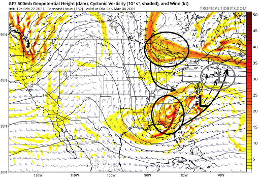
Not getting swept away in this ...it's just as is, this GFS has motioned distinctly toward the 'subsume' model phasing... Getting to this set up at 162 hours in a slackening gradient -- > increasing entropy, is a bit of an undertaking so we'll see. Am aware that it is joined by a GGEM "trend" ... It's in that D6-9 window I was mentioning early so from where I'm sitting it bears watching.. Basically animating that above.. the polar arm/oval above Michigan rotates into/ .. captures the southern transiting SW ... notice the gap in teh 582 to 576 height contouring over Miami - that's critical ...because the flow relaxation is not asborbing that southern system. It's synergy - a stronger southern system injects more PWAT air/ dynamics for/when the N/ stream captures it then explodes in the classical model of how those work.
-
How 'bout now?
-
Sounds a bit like your impetus is solely in the MJO ?? I'd be leery of that - There's an ambrosia or reasons why an MJO anywhere from late phase 7 to early phase 2 around the RMM, would mean less for us here. The MJO does not drive specific events, firstly. I don't know what your specific level of education/experience/wisdom is, so taking fwiw - it sounds like you're intimating: MJO = big one Primer: MJO is a pattern enhancer. Crucially, it is dependent upon the surrounding hemispheric mode or it cannot really readily enhance. The erstwhile hemispheric circumstance has been out of phase with MJOs on the left side of the RMM as a seasonal-scaled issue. What that means is that any wave presentation currently displayed in that left region, are probably being damped ... In other words, if the surrounding hemispheric mode was supporting, it would be much larger and coherent as a curved trajectory around the side of the RMM. In short, because it is "struggling" in that sense, it's likely not really as able to enhance the pattern. More bark then bite - This is called "destructive" interference. This is actually been the case all season long .. where for some reason, the wave "wants" ( for simplistic brevity...) to be emerging on the left side, but the La Nina ( and probably HC expansion stuff ) are a hemisphere perpetually 'canceling it out'. Notice, we have seen almost no emerging wave strength over the last Phase 2 - 5/6 ranges, which is actually a "constructive" interference? It is interesting that there is no wave attempt/ .. origin over on that side ( as a separate matter ) Trying to sense how destructive vs constructive interference will augment the hemisphere is - to put it lightly - a bit of an artistic undertaking. But, when momentum is struggling to meet a measured value, that tends to imply that the achievement is being offset by destructive interference - so it likely doesn't represent much forcing. The other aspect is the apparent wave shortening and gradient weakening ... that means that any forcing that could remain...may get lost in the obscuring entropy of that breakdown.
-
I frankly have seen nothing that offers any specific focus of improved chances in the overnight. Basically still what we were looking at over the bevy of guidance yesterday. Although the CPC telecon tended warmer in the AO. The GGEM collapsed back to longer term velocity/progression look - not sure why I spend much time with this model as I do.. Only because it's bandied about by NCP ... AFDs and in here and I'm "sheepling" it. Maybe someone has some nsight as to its usefulness. But, it opened that phantom ( we suspected its falsity - ) trough and favors its extended toward lifting out winter. It sends everyone E of the Divide by S of the border through a Chinook processor and solid spring temp spread by D10... The Euro lags that by perhaps a day, but ultimately ends up there by reasonable error/~ half day...clearly extrapolating just beyond the end of that run toward a +8 F afternoon bath for the same area as a general theme.. The GFS has done what it always does between March and July ...every 5th cycle: instead of morphing the pattern steadily toward spring and beyond, ..it merely takes the average January 20th map and scales up in heights and thickness. oh god - we have to deal with that piece of shit antic all summer with V16 now too, don't we. In general the models look to me like they are being physically modified by two sensitivities: - lingering gradient richness and the same battle of extended amplitude failing to hold into nearer term progressivity/velocity gauntlet ... that is routinely wnning and damping those robust systems into pedestrian normalcy or less.. - seasonal curvature shortening/ .. flow relaxation is trying to kick in ...in the heels of that, so a bit of transition bug. I noticed this three days ago, and it's been getting more prevalent The 00z Euro's extended again picks up on this and the GGEM (ugh) now shows it too; the entire Canadian shield cold reserve is rather abruptly modified by a goodly amount in the sub 700 mb troposphere ...pretty much everywhere S of 60 N.. The deep -30 plumes are no longer loading off a flat -EPO quasi arc over the NE Pacific ( that was kind of unnoticed by the way...) over the last couple of weeks. cold relaxes..gradient relaxes... flow slows and buckles... that may open the the door for La Nina and HC to engulf the hemisphere * just a guess. Our entire scope of the hemisphere can flip in a hurry. I do think/suggest that through D7 .. 9 ... there is a pinch low potential, perhaps even one more R-wave integrated. And though the 2nd bullet above ... keep in mind, that is not intended as any instantaneous distinction. It may take a week or so after D9 ... gee, like March does sometimes. There can be bowling balls .. However, as that transition occurs, the R-wave anchored low chances drop "precipitously" beyond D9... and that leaves the rarer bowling ball climo dependency ... Anyway, summary: feels like the same sort of "maybe-ism" we saw during yesterday, for D6-9, was put on display overnight - so... maybe for storm/winter enthusiast, it's not taking away. I was hoping the CPC PNA coverage might show that bulge edging into positive SD... but if anything it went south by a quarter point. Still there though.. EPS notwithstanding... it trend more robust with western heights, but less with the down stream trough D7-8 .. negotiable Someone else mentioned 1997 April.. I almost get the feeling that although there is nothing specific that remotely resembles that at this time... this "feels" like the type of spring that would deliver back-to-back 67 F afternoons, with a 33 F blue bomb ... then 66 two days later. But that's just my mood at this moment.. blah blah...
-
I think I see what’s happening. the Euro paints the way on seasonal change on that 12z run. Not so much in the sense of wave spacing so much but the thermal profile up N across the breadth of the Canadian Shield substantially normalizes between D6 and 10 while going AN S of the border by the end of the run I suspect these buckling complexions are doin so because the gradient is relaxing. I mean it’s bowling season .. shortening wave lengths. it may also be partly why the western ridge /PNA are rising ... interesting. Chances may increase for slower moving marginal QPF loaded systems for a week or two. Who knows after but still waiting for L Nina spring to show up. this buckling showing up all at once though smacks more like recent years tho - recurring theme post velocity soaked hemispheres to do this in springs ... transition. didn’t end to well for early warm /spring enthusiasts. It’ll be interesting to see where this goes.
-
Up .. now they’re going back shit
-
Perfect ... my evil plan for 30" of snow and 70 a week later is almost complete - muah hahahaha
-
Oh, haha...yeah... you should probably do a lot better in Worcester than Philly -
-
It's an interesting thing .. Two days ago we nicked 52 for a high temperature here in Ayer Mass per multiple home sites on Wunderground - so taken fwiw, but it felt that mild. By day's end although the snow was visibly less out in the yard it still had pack look to it... substantial with no bare areas....edge to edge...consistent all over town... Last night, however, that was even more visibly lost- ... yet it was only 41 for high clawing to get there in that nascent polar air. The difference was apparently the sun. Two day's ago, that "coefficient of nape-balm" was missing... lol. No but the ceilings were milk much of the day with tepid sun at times down to orb. Yesterday was thru cerulean blue and the snow on the south side of the house had crept almost half way down the front yard. Just something I noticed... That's why I wonder about the "this snow ain't going anywhere very fast due to density" argument ...heh. Empty an ice tray into the sink, run the cold faucet. That ice is gone in 5 minutes... I mean we get one coastal with thrashing mid 40s rain, I don't care if that's a foot of Italian ice...it's gone.
-
Well yeah...that, and prior to as well... That is why I implied it's not ending in 10 minutes, either I mean Jesus Christ - you can't even bring it up ... talk or lay mention to the inevitability of seasonal change? Holy shit. Not you per se ..I mean in general...
-
Well ... by the underpinning, insultingly obvious smoldering hope of the consensus .. that's supposed to be a good thing - Ha Somewhere buried in the skull of that mind set is a non-disclosing monologue about it 'still being possible' so long as its cold. Fact of the matter is, the engagement in here doesn't have much to do with science - never really has. And it is probably bi-polar for everyone to some degree ( no pun intended ..) or another during these transition seasons. There are times in the spring where the model runs seem to gang up on Celestial mechanics ( i.e., the Earth's rotation/angle relative to the sun and inevitability - ), and those times ...the model cinema drug users get a kick. Those times are bad for spring enthusiasts who've long checked out and long for the sights and sounds and aromas of summer - probably worse for these, too... Because spring in New England, I have come to find, is a psycyological challenge where "April as the cruelest month" is really more like "Spring is the cruelest season" ...anywhere E of the Hudson! Then, those seemingly rarer times when warmth takes over the charts and outpaces the calendar by several weeks, the pendulum swings the other way.
-
No... your sick of it, not because it has been repeated ... you're sick of it because your neurotic about holding onto winter and don't like hearing anything else. Sorry if reality NARCANs people's high. - the difference there is realism: an approach that requires one 'get it' that winter is ending ...whether it snows next week or not - enjoy that. I dunno, what - you hear that and process it to mean absolute - like in 10 minutes ? no - It's March... spring. Winter ends this month both in Met and solar calendars...
-
Raise your hand if you're up to here hearing this goddamn statement - lol It's alright - not you personally... It's just ad nauseam with that and most years since the beginning of the era of modeling environment utilizing tech ( say 1976 ), phasing beyond 72 hours is and was always such low dependability and that being 180 hours: IN spring IN GW IN fast HC poisoned shear shit show of a flow I mean 180 from now...what? Is that July 4th - may as well be. haha. I like the D10 spring explosion everywhere ... big big time warm front in Lakes...
-
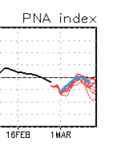
Am not sure I buy it just yet ... seeing as you asked and so cherish my input - lol. no seriously, there's a modality in the PNA that is intriguing coming from the GEFs ... Kind of insidiously innocuous because the curve doesn't actually go higher into positive .. but, the many members all are on the same curve... here, There are a lot of members buried in that nearly collocated curve trajectory ...so that actually lends confidence in a significant mode adjustment across that 5 or so day of that length of time there. I surmised awhile ago that the 'behavior' may be more important than the absolute positive or negative value - and I really believe so frankly ..but whatever. Anyway, the PNA is a huge domain space. It may be that the American ( PNAP ) aspect is more Euro-like, ...but the total Pacific and American domain is pulling the curve down... It's like we have to split the PNA into quadratures...and if so, the PNAP aspect would be greater. Regardless...that above for me signals there's room for amplitude...I'm curious how the heights in the deep south layout though - it could imposed so negative interference from that aspect too - Anyway, as far as that CMC run it almost looks like bowling season antics - which could work out in its own right but if it's not rooted in the above stuff in my be coincidence. And ...it's the Canadian - haha
-
Lol - 90% agree... If you change, "...Through April," to ..'through March...' By April I really don't want snow ever, period. Druthers and reality seldom agree though ...I'm living in the wrong part of the world from ~ March 20th onward. I've thought my utopia would be the girl of dreams at my side, and a second home ... well, 'bomb shelter outfitted to be home,' residence out in NE Oklahoma. Resettle there every spring from then through circa early June... maybe mid May pattern tenor permitting. Then, returning here for mid summer. And every autumn, we have the wherewithal and luxury to tour the world in travels to learn sites and cultural histories in subjects having nothing - thank god - to do with the weather... Returning in November, again pattern negotiable. Although, I might break and key the door in September if hurricane is nearing the PR climo key slot -
-
In any case ... It seems like no matter what salient point one makes regarding the weather patterns over the next three weeks, the emergence vector is always pointed up one's butt - f! It's frustring.. like there really some kind of "Matrix" to the cosmos ...and it exists for that singular purpose. Risking the no-win setup that suggests .. ha, the operational Euro seems like it is a vastly over-amplified version of GEFs PNA index, if one were hoping for cross-guidance confidence. The EPS blend at the free sites I've look over, it is hard to glean support for the operational version as the last several cycles have more and less supported - no clear trend. Maybe a little more amped? But the operational Euro looks like it's gotta be soaring to some +3 PNA. Hm, the Euro also tends to over amp flows in both directions beyond D5 ..it could all just be bs for that reason alone. Still, I would nod to the GEFs for having concerted ( agreeing...) members; en masse they rise and fall almost along the same PNA values. They are all tightly clustered around the 5 day bulge - I think that behavior is more important than the absolute value of PNA apex, ... I'm willing to hunch. One might focus too much on 'positive' or 'negative,' but it goes from -2 SD to 0, which is still an upward correction of 2 total SD mass. It matters in determining a higher impact threat, vs just a nuisance ordeal next week ... There's may be a kind of limit in how much that can amplify though - even with trending western heights. The entire region from S of Hawaii to S of Bermuda is higher than normal heights. It's a part of that same insidiously creeping ... over decades really, aspect I've been railing about and (hopefully) successfully rollin' eyes or readers, because clearly my ultimate goal is to irritate people... yeah yeah HC again but ..heh, unfortunately, reality whether readers are either smart enough, moral enough, or lucid enough to accept, is going to impose limits to the southern aspect of these troughs
-
But what is the metric - all I see is a day, and colors... Okay ...so ( excuse I don't typically look at, nor have I been exposed to that product suite ) that's "ON D+11" - must be a snap shot of what it looks like on that day compared to historically? I don't see what/why "D+11" should bear any particular significance over any other day out in that range ... why day eleven? Must just be 'that's always been that way,' operational lineage thing. Not only that, ... looking at the individual GEF members, I fail to really successfully even imagine how the hell that day 11 from 12z yesterday, or last night's 00z ... could blend out to a that kind of .. what the f are those units in y-cor ?? 90 what? % above average? egh, not in the mood to root around in their labyrinth of online disclaimers
-
How ... and of what constitutes the determination for these CPC analogs ... Is it GEFS ... operational trend, the blend therein ... Any cross guidance? Is it all just 500 mb heights? what goes into the product. what metrics...
-
D10 .. you wonder what the tapestry looks like on D12's extrapolation too - that might qualify as a fair torch as that EC trough loses its footing and that western warm bubble bursts its guts downstream... It really is setting up for a big warm mid month in that look. Noooormally we don't comment on it? But erstwhile the CPC telecon spread bouncing the polar indices in the positive range, while the distant PNA slopes down...isn't exactly a bad foundation for that Euro run, either. EPS ? I'd love that - man... 28.4" yard stick storm then tsunamis warmth in less than a week later. ...yeah yeah prolly can't happen
-
Miami rule in effect too- If the PNA does spike a little more it might over come that.. but, the flow is fast while that SE is merely compressed in that scenario ... That's sort of what screwed the M/A in that 2001 March fiasco... I mean we could trend the western ridge better and dig more, and still have some neggie issues with interference from that region. Ha, it's like everything has to be perfect -
-
I wouldn't toss that entirely ...
-
I think Sunday sneaks in a naper prior to 18z ... still the Euro tries to sun up and hold back the cloud/sature-able ceilings for a bit, and with 850s still in the + 4 to +6 range it might spike to 60 before hand
-
This ... In essence, why I cringe at the very word, 'April' I mean I almost don't mind the 40s in March ? I never was a buy-in for that month anyway. I mean it sucks.. tru But I think because April is really caught in the seam where it's too unlikely ( though yes sometimes rarely ) to get a 1982 job done... or in 2005 I remember seeing blowing snow off a flat roof at 1:30 pm on April 9th or something ... Can't count on that tho... About as much as you can't count on it being 60+ dependable either... It's just like a waste zone and it can be 40 F mist days with gobbling into summer sun times too... Have seen that start taking days out of June and enough is enough, and it takes more. New forecast has a new BD ...like wtf ... thankfully, the plague springs are rare too. Not to happy about the last several Mays back to back... I feel like our summers ( and I am summer Met enthusiasts with tracking thunder and heat synoptics and so forth ...) has gotten bites taking out of it at each end.
-
Stupid to engage in that but no... the GFS is not "an inferno" wtf, c'mon people -
-
Lol...Kevin's reaction to that -


