Typhoon Tip
-
Posts
44,566 -
Joined
-
Last visited
Content Type
Profiles
Blogs
Forums
American Weather
Media Demo
Store
Gallery
Everything posted by Typhoon Tip
-
Monitoring a potential important TV to East Coastal storm: Jan 17
Typhoon Tip replied to Typhoon Tip's topic in New England
It may “want” to lol. But this really isn’t a cutter it’s slipping between climate tracks which is part of the red flag for me. I just think it’s another peregrination … likely to be a week full of them until probably Thur High confidence for an event … probably a significant one, but we are still going to be have to be quibbling over details and unfavorable tracks at times. -
Monitoring a potential important TV to East Coastal storm: Jan 17
Typhoon Tip replied to Typhoon Tip's topic in New England
Welp it’s five days away so whatever… Too tired to do any kind of meaningful mass field analysis to figure it out but just a scratch stab it looks specious to me due to continuity with the upstream aspects. Doesn’t mean much. -
Monitoring a potential important TV to East Coastal storm: Jan 17
Typhoon Tip replied to Typhoon Tip's topic in New England
Yeah I was just looking at the 2 m with high teens interior/N -
Monitoring a potential important TV to East Coastal storm: Jan 17
Typhoon Tip replied to Typhoon Tip's topic in New England
Nah … That thing triple points underneath. But it’s so typical for the Gfs to do this - it takes an oddball solution …everybody complains about it and it makes it even more odd on the next run. Doesn’t look like it’s very climate friendly it’s trying to fit a low between a lakes cutter and a coastal commitment. -
Monitoring a potential important TV to East Coastal storm: Jan 17
Typhoon Tip replied to Typhoon Tip's topic in New England
What was happening all along is that the GFS was using the northern stream to push this thing further east before it came up north so the phasing was happening over New England and so forth …but in this run we noticed at around 96 hours, far less northern stream coming in so this thing is just sort of I don’t know why it’s doing what it’s doing but it’s not getting in northern stream assistance -
Monitoring a potential important TV to East Coastal storm: Jan 17
Typhoon Tip replied to Typhoon Tip's topic in New England
I’m starting to wonder if the GFS’s northern stream dominant bias, it “doesn’t know what to do” if it doesn’t have a screaming northerly jet. Stalling …. -
Monitoring a potential important TV to East Coastal storm: Jan 17
Typhoon Tip replied to Typhoon Tip's topic in New England
Wondering if this GFS run may actually be further west. Essentially the same thru 84 hrs …,maybe a pube west -
Monitoring a potential important TV to East Coastal storm: Jan 17
Typhoon Tip replied to Typhoon Tip's topic in New England
Jesus… Not that it’s worth it to analyze but that particular storm depth and track being from southern stream origin like that? If it did exactly like that there would be 20 to 30 inches of snow from White Plains New York to Nashua New Hampshire regardless of whatever that snow tot product shows. If anything the model’s under done with QPF for one but two that’s basically historically powerful frontogen signature there - if that were ever kept track of -
Monitoring a potential important TV to East Coastal storm: Jan 17
Typhoon Tip replied to Typhoon Tip's topic in New England
Entertaining run to click thru tho - it’s got that going for it. It’s doing all that with zero phasing because it’s kicking that southern stream out too far ahead… outpacing the northern stream, which is trying to come down into the backside I have no idea how to correct for this particular model I don’t really pay much attention to it -
Monitoring a potential important TV to East Coastal storm: Jan 17
Typhoon Tip replied to Typhoon Tip's topic in New England
I’m wondering if this one may slow some in future cycles … -
Monitoring a potential important TV to East Coastal storm: Jan 17
Typhoon Tip replied to Typhoon Tip's topic in New England
This would probably be a 12+er from PHL to PWM ... cold would be the only limiting factor - which who knows at this range. -
Monitoring a potential important TV to East Coastal storm: Jan 17
Typhoon Tip replied to Typhoon Tip's topic in New England
Heh, Brooklynwx99 beat me to it - yeah, don't worry about that run.. Not sure folks are getting the message: follow the ens mean, and have fun with the op runs. Not the other way around. I mean, sometimes ...yeah, the op's can lock in? 24 hours ago they had virtually nothing... so this isn't really one of those circumstances -
Monitoring a potential important TV to East Coastal storm: Jan 17
Typhoon Tip replied to Typhoon Tip's topic in New England
Looks like noise to me.. -
Monitoring a potential important TV to East Coastal storm: Jan 17
Typhoon Tip replied to Typhoon Tip's topic in New England
Also... because of this system's total history, by the time it is abeam of our latitude is going to be very large, relative to these NJ modeler events. If we see a closed consensus on an ensemble mean over the BM, this sort of system probably deforms out over the Capital District of eastern NY. ALSO, 5.5 really .. not D6 ... by virtue of size and totality, it's actually D4 down in the TV ... It's a long curvi-linear event, swooping deeply from the plains to capture/phase, then charge up the coast... Size starts to close the gap on lead time in that sense --> increased confidence by weight in the flow... I also would not "plan" so much for a fast mover, despite current appeal in that regard. Firstly, its size means that fast is relative, because you could take 18 hours to traverse the quadrants by virtue of space alone. Also, given to the depth of the system, and the still uncertain influence from possible -NAO flex, at 5 days lead that's plenty of time for the NAO to factor in future runs. Having the heights relaxed over Miami ( general metric...) prior to this whole ordeal, helps the slowing cause. This system, as impressive as its emerged ( rather abruptly ...even I thought it might take a day or so of cycles when I first posted about this this morning - I'm a bit awed at how quickly this exploded into reasonable consensus... ), still has an upside to it, frankly. For storm enthusiasts, you like where this sets at D5/6 lead: it has upside while already being impressive - that's a bit different, when playing the odds, then seeing perfection on a D8 chart. Then knowing it hast to survive probability gauntlet of buck-shot fractals bullets. -
Monitoring a potential important TV to East Coastal storm: Jan 17
Typhoon Tip replied to Typhoon Tip's topic in New England
For now - sure -
Euro has 2-4" kissing the aftermath around D10... that could evolve into deeper player, too.
-
Monitoring a potential important TV to East Coastal storm: Jan 17
Typhoon Tip replied to Typhoon Tip's topic in New England
Don't think we could ask for much better - that's probably right at the performance ceiling for the state of the art of the technology. lol.. seriously though. I've seen much worse at that time of range. -
Monitoring a potential important TV to East Coastal storm: Jan 17
Typhoon Tip replied to Typhoon Tip's topic in New England
yeah... what -
Monitoring a potential important TV to East Coastal storm: Jan 17
Typhoon Tip replied to Typhoon Tip's topic in New England
This is probably going to be blue bomb grid problem for a 50 mi wide swath wherever the coastal plain wind bends NNE, and locks 31.9 - 32.5 F under a 55 dbz water coated aggregate returns. man wow, is what that is. -
Monitoring a potential important TV to East Coastal storm: Jan 17
Typhoon Tip replied to Typhoon Tip's topic in New England
Yup...and thx for the Euro cluster there - Yeah, these are really just another ens member at this range, frankly. Doesn't mean much for detailing an event that is on the "other side" of Friday's handling ... that's the other thing. It's still a wild card imho, not for how it impacts ( less is likelier ) but how it interacts with that -NAO flex going on up there next weekend..etc...etc... usual headaches --> back-logs an effect on the upstream eddy and all that fun. I mean, this thing could end up stalling - I can visualize several outcomes ... none of which are outside possibility. I'm really more impressed that this was signaled 3 or 4 days ago... laxed some in the interim, only to came back like this. It's got that history, but also fits the telecon numerics. Sometimes bigger events have so much physical "genetics" ...they're almost like recessive traits ( LOL), that they keep showing up. Then, there we are - We'll see. I think this thing's confidence as actually being there and real, leaped into higher tier like a 1990's pop star. We're in ens mode though. -
Monitoring a potential important TV to East Coastal storm: Jan 17
Typhoon Tip replied to Typhoon Tip's topic in New England
We're going to have to play that factor .. modulate in as the week unfolds. Right now we have a modest -NAO that appears to be over the western limb of the domain - BUT - not so overwhelmingly so that it suppresses the storm track altogether. As an early "hunch," that it is not favoring western New England tracks - but the NAO is vagarious, often inside of weekly time spans... And it's transitive influence on how/where this or anything else that comes of it ultimately moves, is sensitive to nuances - we'll have to see. This is all made possible by Pacific flow corrections if you ask me. I mean the telecon was suggestive, and the graphics left something to be desired... they've merely come into sync now - boom.. I don't think this was random change. -
Monitoring a potential important TV to East Coastal storm: Jan 17
Typhoon Tip replied to Typhoon Tip's topic in New England
I'd stick to the GEFs ens mean vs the EPS ense mean vs the GEPs ens mean, and negotiate between them for the time being. These operational runs are likely on the western edge of their clusters, and don't have to necessarily be the true track and intensity and everything else blah blah blah 100 Xs we go through this -
Monitoring a potential important TV to East Coastal storm: Jan 17
Typhoon Tip replied to Typhoon Tip's topic in New England
This could actually be a huge run if that captures... The southern component in that dog 'n' poney show is moving out ahead, cyclonically rotating relative to the mid west trough dive, and that's a risky recipe for "subsume" type of phasing... I think we nailed the call that this was an early consensus happening over night and now the game may officially be afoot - -
Monitoring a potential important TV to East Coastal storm: Jan 17
Typhoon Tip replied to Typhoon Tip's topic in New England
Yup... remember it vividly... I had moved from Rockport Ma., to Acton Ma ( Family relo ) the previous year. I remember the night before it struck, it was 38. Acton Mass. The air actually carried the aroma of rain, which I thought was interesting as we were headlined/warning for snow. That storm is the only storm that I ever recall before, or since, that snow parachutes like 8/10 of the time. 18" of 'em, too. The last 6 hours of it was light snow and more powdery. At the height of the storm, visibility was 1/4 mi, with giant aggregate balls going side ways in winds vaguely audible inside when gusting. I remember seeing them some times smash into pieces when they hit the wires and tree branches... It was weird and exotic, and really ... was the first, first-hand experience I had with New England winter storms ... as I was still just a three years in as newbie to New England as a young teen - western Mich is like a colder drier variant of this climate, here. It was the first storm that also matched the legends I'd been hearing about since arriving to this region at the time. -
Monitoring a potential important TV to East Coastal storm: Jan 17
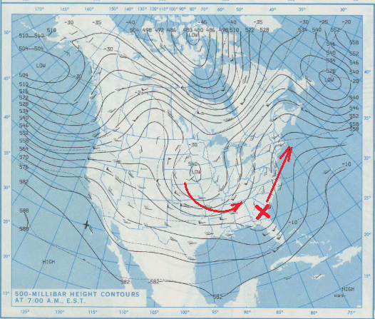
Typhoon Tip replied to Typhoon Tip's topic in New England
I don't mean the ZYZYGY storm as an outright analog ...just that the set up aloft remains me of a similar feed-in... Might be interesting to check out the analogs/CIPs ...once this thing is being picked up. Bearing similarity isn't really a anolog necessarily ...heh. this is Jan 2nd 1987. It shows a partial phase with mid west larger mechanical low; as it descends, it encourages the flow ( and anything in it's amber) along and astride the EC, to tip N and move in that direction. The "X" spawned a low in that vicinity and ended up pretty deep and large nearing ACK 24 hours later.