Typhoon Tip
-
Posts
43,395 -
Joined
-
Last visited
Content Type
Profiles
Blogs
Forums
American Weather
Media Demo
Store
Gallery
Everything posted by Typhoon Tip
-
Well in Kev's defense ( oh god ...), he did say ICON...
-
Define the purpose of monitoring "just the arctic" when the "spirit" of doing so is for on-going climate monitoring. This is a Global problem - it should all be contained.
-
Maybe we'll get some improvement later on today but these temperature stumping pancake skies aren't the most pleasant out of doors. This thing over the weekend is road kill ...smearing its guts out E of NF yet still... all but entirely in the grave it's reaching a tentacle back to fuck the coastal folk -
-
Yeah all that .. but that thing out there would make a September 3rd grader jealous. Man it's like completely incongruent. It doesn't look like a June anomaly where it's kind of stuggling ? ya know - this thing demonstratively looks like an apex seasonal bomb is about to happen.
-
I'm almost wondering if the unusually early and pervasive N/A fires might be causing unusual behavior in the insect fauna in general. not just squitoes... I mean us disc golfers aren't being harassed by those Green Heads on blood recon, either. You gather a couple of them f'n bastards and you own 'em the whole day. They tirelessly fly mobius loops around your head - they're so much fun when you actually swat one with a disc. They're usually pretty bad by late May and we haven't seen any of those, either. Anyway ... like some plant species are natural insect repellents - is it possible burning bush materials might have deterred ?
-
No mosquitoes here. Which seems rather odd considering the heat's been null and we've had some decent rains this spring. Usually by Mem DW it's an atonal chorus of shrieking whir out there but I haven't seen a single mosquito.
-
Huh? sarcasm? that verdancy is breathtaking - gorgeous image.
-
No argument! I was just musing to PF last night, that talking about pattern changing doesn't sell very well after Stockholm Syndrome has taken toll and it's thus quite mythically utterly impossible - haha
-
Jokes aside... stepping back, waaay back, and just sort of characterizing the last 10 years ... it seems there's a real phenomenon ( however faux due to shorter sample size, notwithstanding - ) to smear the seasons together? I mean that's not statement of fact ... again, just the distant 'illustrative impression' Obviously, winter's colder than summer, duh.
-
This may not technically be the thread for this but what's up with the Atlantic SST anomaly distribution? West of ~ 40W, the Basin looks like it's in a wildly tripole mode, while east of that ... looks like "no-pole" I suppose it's diametric from W to E, but to see that so coherently so like that, that's fascinating. Get a load of the insidious deep cold anomalies out there S of NS. And notice the near scale topping warmth that's pervasively immersing an enormous area of the NE Basin.
-
yup!
-
It's like the Seth MacFarlane movie, "A Million Ways to Die in the West" with Charliz Theron. Only in New England, there's a million different ways to keep it cold and CAPE starved. Lol
-
I feel there's some chance that a vestigial long-wave axis may set up neutral axis ... somewhere around the Appalachia longitude, give or take. The EPS and GEPs outright do so by D10, whereas the GEFS does as well, however ... positions the "super structures" too long in wave length for either the amount of gradient complexion over the hemisphere, as well as the recent -GLAAM. Not sure we're losing this latter index, so I suggest losing a GEFs isohypses in the means and that might allow more meridian curvature/W correction. We may be dealing with a "seasonal relative negative index" AAM for this summer ... first half of it anyway. Anyway, the short version of that is, a remnant L/W positioned more like the EPS and GEPs would seem a better fit. From a "super structural" perspective, having such a weakness west, constructing a deep layer S flow ( 'Bahama Blue'/EC parallel subtropical conveyor) is a reasonable fit for the standard atmospheric index changes projected to occur over the next week to 10 days. The PNA is supposedly less statistically coherent during JJA, but that doesn't mean it's not coherent at all... It's moving from negative to neutral/positive during this next 10 days, whilst the NAO is moving positive. It's a weak eastern trough signal, embedded in a eastern rising heights (+NAO), so the "telecon arithmetic" likes it Heh, as an aside ... it's interesting to have a historic June MDR activation when considering above. I've always fantasized seeing Nassau to NYC pipeline in place while the MDR delivers a cyclone west ... regardless of the time of year. Muah hahaha. It'd have to be a long shot... longer then the typical length haha. I mean any given moment in time, the MDR is much more likely to fail to recurving early, anyway, but during a -AAM local slow structure tendency, that would seem to make getting this far west odds even longer.
-
You could tell there was going to be two Invests by the end of today looking across the MDR. i’ve noticed this over the years that those TWs tend to come off in pairs. Often times the lead wave will “eat” the SAL and sacrifice itself for the second one… I mean I don’t think that’s what’s going on with this scenario, but seeing the duple waves, it’s not a surprise to me.
-
This pattern is breaking down really during this week. This was probably the last of the cold pocket severed drift down over New England butt poke troughs. Even if we don’t get the heat wave at the end of the week, the pattern is different - it’s not going back to this. Tell that to people right? It’s not gonna fly until they start to feel it or see it but that’s what all the available techniques and tools out there are really signaling at this time.
-
It seems we should all be more concerned with this … Sea ice extent in Antarctica drops to record lows in 2023 Area of the ocean with at least 15% sea ice by year, 1981-2023 Source: National Snow & Ice Data CenterGraphic: Parker Leipzig, CNN
-
We managed 74 for several hrs while the breeze went nearly calm.
-
I doubt it will be like this next weekend. Pattern’s more likely to fade into a hybrid Bahama blue /EC parallel circulation type if the ridge really breaks down that fast. This recent trough was likely the last of the cold pool above mild breezes.
-
this one's been memed around quite a bit... It absolutely detonates the tree into fibers and pretty much ends its life. (f'n tree! huh)
-
Kinda makes you think about the dangers of any exposure at all to a thunderstorm. I can't tell how many times I've stepped out for a geek moment during thunder ..geesh. Like, ...oh say, just gonna step out on the deck for a second to check out the storm. heh
-
electrical impulse doesn't always convert to thermal energy - it can "disassociate" matter too. But yeah, it's still a fair question.
-
It's rare but not completely unheard of ... I'm wondering if the 'marine heat wave' that's presently observed may be playing a role, as I'm sure is in the "hot" discussion. Courtesy of Weather.com ...here are the 200 years of June Atlantic cyclones. Interesting that only recently has this begun to happen.
-
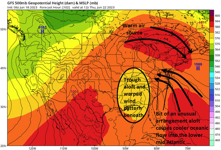
Meh... pattern appears at minimum to be normal, but there's still likely to be some above normal. Not sure extremeness, though some backing down over the the ideas from 3 days ago, as far end of this week, sure. Not unusual ...seems everything that is ever mapped on any weather chart by any weather model beyond any D5, regardless of season, the model has to take 30 or 40 % of the amplitude back when crossing into the mid range. Been bitching about this for years... just the nature of the technology I suppose. Also, week two looks like there's hints at a Bahama Blue pattern there. The Euro stalls the L/W along or just west of Appalachia beyond D7 and establishes a deep layer DP flow out from east of Florida. GFS has been doing quasi the same. That may trade a "failed" heat wave in the foreground for deep blues next to white tower bee-bee shower in humidity. Might be interesting that models have been toying with an early MDR - I've often wondered why there was never a cane approaching the Bahamas with a Bahama Blue conveyor in place. Or maybe that was 1938 Not sure that's less than summery ...it's just not 94/72 under dusty blue.
-
Well ya sold me at, "...the internet says it can" haha... No but I've heard of this in the past. Windows mainly ... but the wood edifice component makes me wonder if a stepped leader were in involved with that, too.
-
72 and mostly sunny here... It was pancaked in about hr or 2 ago but has since opened up quite a bit. I guess if one is up in the mts up N or near CC Bay where the soothing aloe of Labrador's ass vomit death kisses the coast ... sure, it's an unwilling anus day. But it's probably going to improve... maybe later if the gradient orients more NW--> SE ... Btw, whom ever said that, I am not "pushing" for 90s at the end of the week. I never did. For everyone else, I'd pump the breaks on widespread heat anyway. The indexes offer a signficant heat signal, but the operational runs are having a hard time fully committing to it. These recent GFS runs won't allow it to get significantly hot. We should assume at a mere 108 hour out, the performance wouldn't be too crazy bad but who knows - the flow type is nebular and with loss of coherence comes more randomization. You kinda need R-wave structures to get better generalized predictive skill. Anyway, enjoy your usually displaced trade-wind easterlies at high latitudes - a recurring theme in recent springs and early summers going back some 5 to 7 years btw.