

Typhoon Tip
-
Posts
42,023 -
Joined
-
Last visited
Content Type
Profiles
Blogs
Forums
American Weather
Media Demo
Store
Gallery
Posts posted by Typhoon Tip
-
-
Seldom does virtuosity sell ... buuuut,
- be happy this weekend isn't MDW or 4th of July. Hm?
-
10 minutes ago, powderfreak said:
Big soaker there.
Euro..

GFS…

I've personally never seen a 'big soaker' arrive by the means that models are delivering that thing...
Truly a very bizarre total synoptic cinema there - for too many reasons to bother labeling.
It just shouldn't be doing that.
-
 1
1
-
 1
1
-
-
Ugly ugly look crashes in Saturday morning, huh
yuck. 544 dm thickness plume drilled all the way from Greenland as though it was targeting New England by Sunday. Then we set up a 5-7 day synoptic dread ball trough.
-
4 hours ago, powderfreak said:
43F for the low.
A nice 44-degree drop from yesterday afternoon.
Crushing some diurnal swings in this dry air mass.
Yes ... but this recent 18 hours was augmented by this front.
This wasn't really a BD now that I look at this. The front just descended on a steeper azimuth. It was what I call a "north door front" heh.
The thing is...behind the front the wind cuts around the ENE but that's because of the orientation of the higher pressure being due N of the region. Makes it physically observe as though it were a BD.
It may in fact be more so a BD down near Philly ...should it get that far S along the coast.
I don't know why I'm bothering to make this distinction lol
-
7 minutes ago, MaineJayhawk said:
We've got the dews on Mount Desert Island .. 79/56 at BHB. Cheers!

I dare you to give 'er a push -
-
 1
1
-
-
35 minutes ago, wx2fish said:
Tip approved backdoor next Sat on the gfs. Hopefully we can moderate that.
I think we can... Just like tomorrows deal became less as we've approached, it has a chance to minor out some.
Tomorrow will be more so felt where you are compared to CT ...or even Brian ( sometimes it curls under if it is shallow enough).
BOS is hosed. As is PSM... But back here W of 495 .. seems there is a modest NE wind pulse around 12z tomorrow morning then the winds get really light by mid day, whence I am noticing the pressure exertion is more oriented due S - that 'might' hold the marine boundary layer taint closer to the coast.
Anyway, point being ... seeing as nasty BDs at this time of year can still drill 48 F/drizzle strata clear to BDL, I'd call that a relative win. Thermal fields would still support mid 70s where ever the ocean doesn't interfere.
-
6 minutes ago, powderfreak said:
No, I don't know why it displays like that. That is 4pm UTC.... so 12pm Eastern time. It's current.
I'm in awe of 86/29F up here
 .
.
12-13% RH is fire weather.
Actually ...no right that makes sense. I didn't notice the UTC in the header
I was like wha -
-
4 minutes ago, powderfreak said:
What a day.
IZG is actually hitting 90F now on some of the 5-min data... with dews well into the 40s and 20% RH.
Looks like NW downslope into NE MA, S.NH, and ME are the leaders so far.

those are the prognosticated 4pm temperatures?
Bit if a cool bust if so..
It's 87 to 90 everywhere below ~ 700' els and it's not getting cooler at 4pm. 1,000' ORH is 81 ...
-
1 hour ago, forkyfork said:
cool meaning slightly above average
I think there's a small (so far..) possibility of a 'hot burst' ... perhaps a low end variety, out there toward D6.
Some ensemble members of the various product sources have been lighting up Ontario with +21C 850 mb, with newly arriving trend to shallow out the Maritime trough.
The latter aspect is apparently related to the repositioning of the -NAO block toward the eastern limb.
Anyway, that leaves a residual WNW/NW 500 mb flow and it's a possible open unabated synopsis to bring that kind of plume down over the terrain/trajectory that normal cooks the 95 corridor.
We'll see if the operational runs start picking up on that - altho the GGEM looks similar at 00z.
Overall, agreed ... that D6-13 back-carving deep -NAO related hemisphere idea seems to be in the process of modulating toward less. We'll see if continues. It wasn't altogether very believable to begin with.
-
Kind of a weak sauce BD ... The 12z MAV is only modestly cooler Monday when compared to what a BDs are more typically capable of - imposing the minimum cost of 25 F off the highs the next day. According to it, and the MET machine, it's still low to mid 70s even as far NE as KBED in former 'aft' side of the boundary.
Btw, MAV send KASH to 91 tomorrow ... not bad.
-
 1
1
-
-
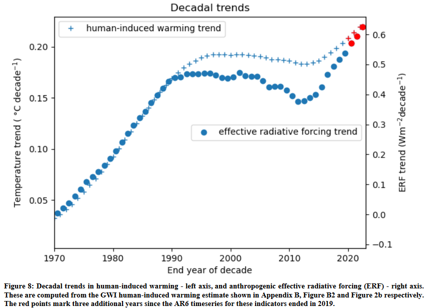
5 hours ago, chubbs said:
IPCC scientists have recently updated the state of the climate system through 2022. Its turning out to be an interesting decade. Chart below shows human induced warming, which is calculated from observed temperatures; and man-made forcing estimates on a per decade basis. After a period of relative stability from roughly 1990 to 2015, man-made climate forcing and global temperatures are increasing at a more rapid rate. The recent forcing increase is mainly due to air pollution control in China and other developing countries, as global CO2 emissions are leveling off.
Below is the closing para from the paper:
"This is a critical decade: warming rates are at their highest historical level and 1.5 °C global warming might be expected to be
reached or passed within the next 10 years. Yet this is also the decade that global greenhouse gas emissions could be expected
to peak and begin to substantially decline. The indicators of global climate change presented here show that the Earth’s energy
imbalance has increased to around 0.9 W m–2, averaged over the last 12 years. This means that there are large energy flows
into the climate system and rates of human induced warming will remain high as greenhouse gas emissions remain high.
Nevertheless, these warming rates do not need to be locked in as rapid emission decreases could halve warming rates over the
next 20 years (McKenna et al. 2021). Table 1 shows that although global greenhouse gas emissions are at a long term high,
they are beginning to stabilize, giving some hope that over time the indicators of global climate change presented here can
track a real-world change in direction"https://essd.copernicus.org/preprints/essd-2023-166/essd-2023-166.pdf
That is really interesting ...
You know, this hearkens back to a discussion Liberty' and I had many tens of pages ago, in either this thread or some other one in this sub-forum ... something like two or three years ago at this point, pertaining to a kind of "whiplash effect" -
The cleaner air ( smoke discharge from increases in wild fire frequency, world over, notwithstanding ) isn't exactly the same, but perhaps there is some usefulness, as a loose analogy, to demonstrate the 'elasticity' of the Earth's systems. Basically, for decades of warming the Earth's vast multiplex of compensating ( more or less ...) forces have been adapting to the warming world ... Suddenly, the ability to warm is removed: those adaptive forces don't merely turn off... Then what?
The whiplash effect is more of a slow moving repulse scenario/idea. Sure. But the aspect above, where the aerosols that cause all kinds of problems ..are reduce rather quickly, and now the sun shines stronger, ... greenhouse gasses are absorbing more LW rad, and that exposes the real potential for heating. In general it shows how supplanted factors get suddenly exposed and become more dominant.
It's sort of similar.
By the way... the following type of article has been getting published with increasing frequency around the world. https://www.cnn.com/2023/05/27/world/meteorologists-conspiracy-harassment-abuse-climate-intl/index.html
It's somewhere between rage inspiring and just flat out comical - perhaps "predictable" is apropos.
-
11 minutes ago, weatherwiz said:
This
is ridiculousshould be considered more normal than not for this climatology, anyway. My friend and I even pushed back our two weeks this year until the first and second week of June - and we're considering that lucky if it's worth it. We always did last week of May/first week of June and had success each year from 2009 when we started through like 2018, but we are correcting back to climo now so it's to be expected - we have nothing to complain about if/when being realistic. I think one year sucked. Then we didn’t in 2019 but didn’t the covid years and started back last year. Last year sucked so we pushed ahead. This isbullshit. Sick of this crapwhy I am going to be looking for move to a region of the country (finally!) that is more likely to produce.-
 2
2
-
-
20 hours ago, CT Rain said:
I think all of us do
Seems there's a modest attempt to back off momentum in the guidance. In general... I get the feel that this is a middling BD for eastern regions, and probably more of a wind shift ... Maybe 10 F type cut back toward CT... 88 to 78 there. But 88 to 65 for SE NH/ NE MA
This is actually impressively model imo, regardless of amplitude. The globals hit on this feature like 4 days ago and have been pretty persistent about it. The modeling in general - from what I can tell ... - has vastly improved with these low level events, ... so much so that sometimes they are even over estimating them. It'll be interesting, though incredible nerdly ..lol to see how this one evolves. The Euro at 00z almost looked more like a NNW-SSE moving boundary as opposed to a BD. That may be why some of the cooling is backed off slightly from that model, because it's not mashing up the GOM heat sink ...
Figures... my buddy's invited the whole circuit of us to his pool party.
-
2 hours ago, CoastalWx said:
Right back to troughing next weekend and beyond. Fortunately in June it means nice weather I’d it’s dry, but certainly no heat or dews. A shame.
Meg Griffin the GGEM ...? haha. That model was very much less aggressive with that whole -NAO back loading/retrograde idea that the others are [probably] going to be more correct about, just too deep/amplified. It offers up early heat into N-W New England and probably d-slopes us with it... with seemingly no end in sight.
The things is ... I'm suspicious ( not that anyone's asking me here ..) of that N Atlantic and Maritime Canadian look. I don't see how/why there is any upstream R-wave forcing across the Pac relay throughout the N/A continent that necessitates all that cumulative height depth formulating there. As a result, it's sending the NAO down to cold Hades by virtue of deltas in the other direction. I don't think teleconnector computations really know the difference. So we get that index that challenges climo ... while the operational Euro and GFS both seem to be non-dispersive, relative to there ensemble means .. which is fine, but en masse they all look weirdly unbalanced with the R-wave distribution.
The GGEM also looks weird though. Lol The flow at hemispheric distinction is clearly slacked off and breaking down seasonally - that may be red flag in general not to trust the shape and amplitude out there in time. I dunno
-
1 hour ago, csnavywx said:
The PDO signature erosion is overwhelmingly due to the insane ridging over the NW Conus and far W Canada over the past few weeks. More of that likely on the way, however that may not impact the southern half of the signature much at all. Looks relatively cool in the subtropical belt for a while yet, especially if blocking stays anchored well north (as currently forecast).
Yeah...I'm not sure how superficial the PDO modulations we have been observing really are ( or not...). They could easily be explained by transient pattern-related sea-surface wind stressing... Perhaps we are heading into a +PNA summer? ... still, as June ages onward, the R-wave coherency may limit that suggestion up there and some of the wind patterning may move toward a boreal summer footprint and the SS goes with it. Not sure -
-
1
-
-
The Euro backed off aloft a little with the wholesale BD mechanics yet the surface evolution is even more aggressive
jeez.
-
18 minutes ago, powderfreak said:
Mid-50s north to mid-60s south.
Pretty crisp non-rain air mass for this sun angle.

Can't wait to see the monthly global state of the climate pub for May... Mid latitude eastern N/A continent with a blue hole when the rest of the world is killing species
-
1
-
1
-
-
32 minutes ago, so_whats_happening said:
Only issue I have seen just recently with Bom is the forecast of MJO. Ever since it crossed the 4/5 it has consistently shown a strong MJO wave chugging along through 6/7/8. That has yet to happen in fact as weird as it is the GFS actually hit the nail on the head with the MJO progression thus far. Meaning if Bom was right it would have really set the stage for a powerful El Nino to take hold as it would have likely eroded the trades around the dateline quite substantially as we see it now it still is struggling but not for trying to get past the dateline. We will have a brief 2-3 days here where we see some nice relaxing around the dateline before seemingly having another round of decent trades poking their head in.
Many of the models that predicted a low amplitude MJO wave show it peaking around 1.5-1.9 (maybe briefly into super category but trimonthlies stay in strong category) while Bom is pushing near 2.5 if not close to the strongest warming we have seen. No doubt overall the WWB event got halted around 150E and in fact some forecasts show a westward propagating WWB with trades pushing westward so this would indicate overall VP is still over maritime region with little indication of this heading east. The interesting part about that is we saw the exact same thing happen back in February which led to a weakening of trades and thus a WWB event across the eastern Pac. This could very well happen again which would help again slowly expand the warmer waters westward into 3/3.4, ENSO 4 may be a struggle for awhile.
If we can manage a nice uptick in 3.4 over the next month or so it gives confidence in a strong event otherwise still moderate may be the way to go for now. As for the PDO talk, while NE Pac has undoubtedly warmed overall the -PDO is not gone. We still have the warm tongue east of Japan and the overall coolness enveloping the the periphery. The biggest shake up to see things move around will be getting rid of that warm tongue, if we can at least start to push toward a neutral mode it stands a chance at topping near strong but otherwise again conflicting signs dont typically work out well.
JMA did really well, too
-
1
-
-
Well wouldn't you know ... the models just couldn't resist and now they've engineered a BD for Memorial Day...
It's more or less defined depending which guidance, Euro being strongest ... GGEM between the GFS which is weakest, but they all have it.
Thing is, the GOM and whole Labradorian rectal realm is still holding back shockingly chilly farts at this time of year ... So, when/if the model physics detect boundaries moving SW like that, we have to be leery of the reality being a 1,500' slab of chillier air at very low levels that hints aromas of cold Atlantic low tide, even as far inland as 30 or 40 miles. I've scented that in Ayer in the past, and I'm west of 495 by 10 miles...
The reason for this is they are introducing a stronger trough diving out of NE Quebec toward the outer Maritime region, whilst also opting to lower heights over us little over previous runs. So that fans a cold from SE aft, demarcating the SW moving dense air and there's no way to stop it ...
Fwiw - it's not unusual at all around here to fail a clean move into a warm pattern without that kind of interruption yanking the temperature back for 30 hours. That's precisely what the models are attempting to do; a total evolution between Sat and later next week that contains a BD interrupt. Saturday bounces back from today and tomorrow's local time span nadir, Sunday is the warm day, and then Monday gets butt banged by 10 am and all those cook outs end up under 54 F strata - Boston Celtic's pattern
Doesn't mean it has to happen... but the 00z was D4.5 ... and it would almost make sense that this 12z, being D4 ... would be the window of performance thing where the models get more coherent all at once, and then all these forecasters have to face the music. Hopefully not in favor of BD - ...
-
1
-
 1
1
-
1
-
-
But I am presently intrigued by the notion that ENSO modes could actually be the correction mechanism in the grand scheme…
-
1
-
-
13 minutes ago, Terpeast said:
This, to me, sounds like further validation of the recharge oscillator model for enso.
Heh. I didn’t know there was such a model haha
sure - “oscillator model” pretty much exactly sums up what I was after, so why the hell notI wonder if that kind of oscillator model theory does drive the ENSOs from the outside in
-
1
-
-
You know ...it sort of exposes the question of whether the long thought/accepted ENSO as a forcing mechanism is really sort of backward in a sense. It's really like some sort of longer period harmonic in the atmosphere that drives from the outside --> in, and then this generates SST anomalies that than integrate thermocline ...etc..
Interesting conjecture there. ENSO may then become a positive feedback - or here's a thought... The ENSO is actually a correction mechanism - oooh. Like a larger planetary manifold forcing causes "Nina" vs "Nino" conditions, then the ENSO responds by what we empirically measure in the SST and thermoclines, which eventually overwhelms the larger scaled mechanisms that caused ... inevitably leading to the demise of the causality --> the switch. Which will inexorably leads to an overcompensation in the other direction, and the cycle is sort of periodically resetting between the Nina and Nino states - modulated somehow such that it is irregular in duration.
-
2
-
1
-
-
"In reality, global AAM* has become exceptionally high in the last 10 days. High AAM is characteristic of El Niño's atmospheric component."
It is...which is why in part I also mentioned this a while ago, that the atmosphere outside the immediate dispersion domain of the ENSO band (fascinatingly) appears to be outpacing ENSO itself...
I wasn't referring to the Angular Momentum stuff but it's another evidence to the same extents
-
1
-
1
-
-


June 2023 Summer Begins
in New England
Posted
Wrt BD phenomenon... I did an under grad research into this ... decades ago, when the dinosaurs reined ... turns out, there's like an 'average whiplash' value that seldom exceeds 40 degrees as the maximum 24 hour SD. Basically ... 80 to 40 in April ... or 90 to 50 in summers. The frequency of d(T)/day = 40 ( between 35 and 45) was higher in February - April, than falls pretty quickly by the end of May.
If going by that latter aspect, this is getting perhaps a little late for d(T)/day = -40 ... But the event in itself ( probably in the 32 to 38 range when reality pushes back on guidance ) has plenty of company.
What I found interesting about that statistical review was the definitive tendency to 'move together' ... preferentially 30 F was the standard. If it was 90 and the BD came in, actually getting d(T)/day to exceed 30 was dropped off pretty abruptly - though there were occurrence. Then there is/was a large smear of in the 10 to 20. But it was pretty robust. 96 --> 66... 76 --> 46 Something about the antecedent synoptic wholesale structure tends to limit the correction extreme, regardless of time of year, too.
That was as of the mid to late 1990s and combing through chart library and identifying BDs like any TOtally normal person would ...heh. There are some -45 outliers though... March 1998, and since graduating ... I recall also April 2003 approached 50.
Anyway, the 06z GFS ... well, actually ... the last 6 cycles of that model, is showing the inevitable bump east with the diving impulse/500 mb structure, as of this most recent frame, keeping it east of Logan. Day ... day and half ago, it was still trying to send it into PA, which as we discussed yesterday was highly unusual and bizarre. The problem is... the 500 mb closing vortex is a cyclonic motion - yet the model was trying to move it, en masse, along an ANTIcyclonic curved value - like the ridge over the GL was steering it - yet, while deepening it? Last I checked, NVA tends to offset PVA
I think this silliness is exposing bad physics in the models. They all were doing it, too. The Euro/GGEM ...etc. Now, they too are bumping east.
But this all has the upshot of trending the weekend ordeal into a standard cool shot and strong BD event - which is like 'more sane' haha. We'll see.