

Typhoon Tip
-
Posts
42,023 -
Joined
-
Last visited
Content Type
Profiles
Blogs
Forums
American Weather
Media Demo
Store
Gallery
Posts posted by Typhoon Tip
-
-
1 hour ago, Torch Tiger said:
There was one in Feb. 2010 iirc, though could be off. all rain. 70-80mph gusts near MHT and we lost power for 8 days.
yeah no that's the one. 2010... meh, 2013 .. 2010 ...it's all one big blur
-
We had a weird Nor'easter coastal in that era ... 2013 or so, whence NE Ma and SE Nh suffered a tropospheric fold event ... unusual because that typically happens on the SW/underside where the stinger is identified on sat and rad. This was in the CCB tube; there were like 70 mph wind gusts doing a lot of power line and tree pruning work ....
it was all rain tho. Late February too - man... a CCB with a tropospheric fold embedded - magine if that were snow?
heh, probably couldn't
-
 1
1
-
-
5 hours ago, 40/70 Benchmark said:
It doesn't really add up IMO....they have slightly above average precip, normal temps...yet below average snow.
I wouldn't know anything about Accuweather bias, nor their forecast philosophies ... but a pathway to a low snow turn out whilst normal temp for our region could be related to an anomalously warm mid level plague -
which in fact, we don't exactly live and breath in an Earth era that's short of reasons to see something like that occurring. just sayn
I'm not forecasting that but Devil's advocate.
-
2
-
-
It gets easier to stagnate the diurnal temperature range in October ... particularly so once in the solar minimum, Nov 8 and beyond. The sloping sun is oblique to cloud coverage and that's not very efficient radiative-thermal modulation with that low incidence.
-
2
-
-
Kerry Emanuel, el al, MIT describe the Polar Low phenomenon in a paper titled, "Polar Lows as Arctic Hurricanes"
The abstract alone is geek's one-eyed monster worthy stuff ...
"Satellite observations of the polar oceans have revealed the presence of small, intense vortices
that often resemble hurricanes, having clear central eyes surrounded by deep convective
clouds. Recent aircraft and drop sonde data also show that these storms, like hurricanes, occur
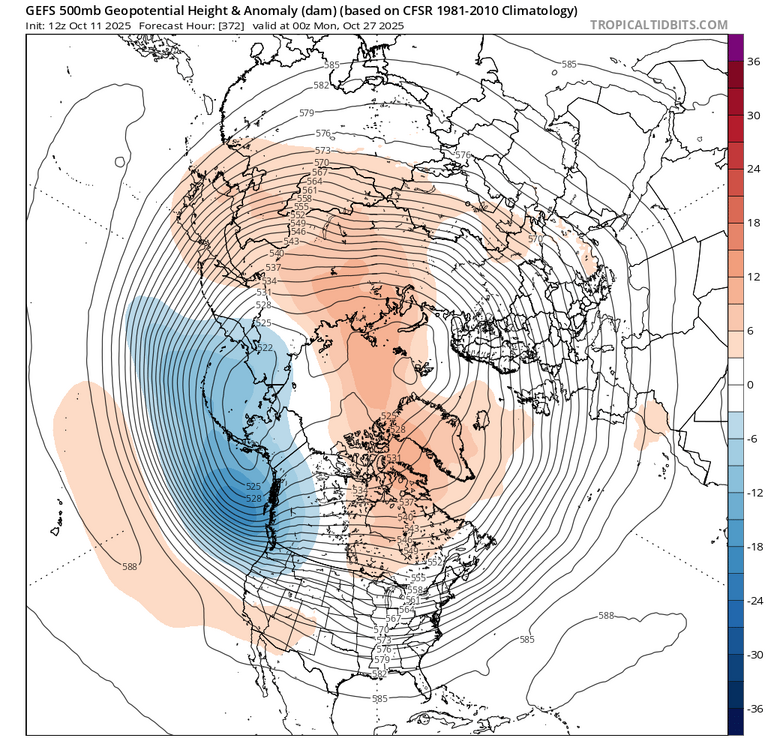
within deep moist adiabatic atmospheres and possess warm cores...." ( oh baby; don't forget the step children)I recall back in 2002, the GGEM of that era had a propensity for fusing, or threatening to do so, CAG originating TC ejecta up along the barolcinic wall east of strong +PNAP trough amplifications ( ... that's code for Mr Margrave's chart up there in this thread...). Anyway, Sandy alllllmost succeeded, but I wonder if Sandy teaches us, before ever observing the Sci Fi hyper bomb to best all fantasies, just how hard it is to actually get that to happen. Purely statistical occurrence, Sandy was something like a 1::500 year eturn rate ... does that grossly mean a purer performing phase is 1:1000? ...10,000?
But that excerpt from Kerry's paper above, does lend some intrigue. If the thermodynamics in the tropical cyclone are some how comparable in the internal engine of the arctic variant, is it ever possible to go directly from a TC end of the spectrum right to the arctic end, in some kind of fantastic transition event? It may be one of those deals where it is mathematically possible, but practically so improbable due to everything that has to happen right in precise non-negative interfering order, that it is too unlikely to ever actually be observed. Still ... man. How would that look... and would it be mathematically possible to constrain George from blowing a gasket if that was like in the model movies (now that would be bombogenesis).
Either way, that above is not really that. It's not cold enough... What that would do is just transition, albeit rapidly, from a TC into either an ETC. Or, it gets sheared and pulled apart like a star wondering too close to black hole ...getting absorbed into an ongoing ETC genesis.
-
2
-
-
7 hours ago, weathafella said:
Boston out to 128 about 2-2.25. BOS something like 2.2 I think. Definitely some good rains and the dry pattern seems to have changed based on guidance.
I was wondering if that's an artifact of the pattern changing in and of itself, or seasonal forced reconstruction - so to speak
There's probably no difference there. So long as the pattern changes.. But the flow behavior in the modeling cinemas looks more charged, sped up with wave propagations that have real gradient. It's come on sort of sneaky over the last week, but now is much more coherent and raging going forward. Heh. It's almost like it's not so much a "dry to wet" pattern change, as it is a wholesale systemic change where getting more rain is intrinsic. Being that it is October and no longer July well...
-
5 hours ago, GaWx said:
This won’t be a popular take here, but I think articles like this do more harm than good as regards believability regarding the affects of CC in general. It has a sensationalist, “Day After Tomorrow” tone to it imho. This isn’t the way to convince nonbelievers.
Some of the words/phrases used in the article were these:
catastrophic, catastrophic ripples, devastating consequences, alarming, catastrophic global consequences, catastrophic outcome for all humanity
I think that articles like this do more harm than good. And I’m saying this as one who’s extra concerned about sea level rise and stronger hurricanes being that I’m not far from the coast.
Not sure I agree here... We ARE in a catastrophe, a slow moving one. Too slow to be seen in what we call "real time", or human perception, but that slowness only beguiles us into a false sense of lessening urgency.
Don and I ( and any others et al) have been discussing about the limitations in the biology of all Terran life ( for that matter -): for all species, urgency is aroused by what their senses are telling them. Human beings, as far as can be empirically tested, are the only life forms on this planet capable of prognosticating doom or boon based upon projection. But we still procrastinate, if not outright disregard those forecasts when the evidences are not directly appealing as such. You know ... what can be seen, heard, smell, tasted., or touched. The tree does fall in the woods whether anyone is around to see it happen or not, and in this case... it's particularly bad because the proverbial tree is falling right in front of us, yet is unseen.
But it's still falling
-
2
-
 1
1
-
-
8 minutes ago, powderfreak said:
LoveIt's annoying how much of the discussion revolves around imaging this in winter and how elated or upset folks would be.Some things never change. Winter
still rules the forumcomes in 2nd place behind psychotropic addiction to weather chart drama.-
 5
5
-
-
Climo nor'easter in the end...
That's only by impact too - most coastal storms don't emerge the way this one did, with such torpid H500 evolution amid what looks like a spaghetti plot of isopleths.
-
1
-
-
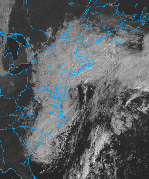
At least we got a decent Saturday ( recently ...), because this, this day is why I don't believe New England is worth it in the long run. I just find this to be more loathsome than any so-called top 10 day is lovely. There can never be equality in a weather solvency becuase bad vs good? the bad is always that much worse.
Anyway ... I'd lost track of how many proverbial top 10 days we'd had since mid summer. Eventually ... some sort of justice ( seeing as New England is clearly persecuted for ever experiencing weather joy ) was going to come calling. This, here on this day and as evidenced in this satellite shit show below, is the ass of the judge hangin' over us ... midway through a colonoscopy prep
-
3
-
-
-
5 hours ago, Torch Tiger said:
wowzers
If that happens the entire Pacific oceanic heat wave it’s called ..,east of the dateline is going to be eradicated at a record rate.
That’s unlikely though-
1
-
-
8 hours ago, WxWatcher007 said:
Remember that winter a few years ago where it seemed like every good storm track had some weird dual low structure?
It’s real and you know why it’s happening don’t ya
-
1
-
-
1 hour ago, Snowcrazed71 said:
Well, I'm sorry your not getting your catastrophic wind event ( I myself am not ). However mundane it is for you, it will be welcomed by many for the rain we will get. Don't get me wrong, I love a good storm, but I don't want trees down all over the place around my property or on my house, and I'm sure many will feel the same way.
Bring on the rain.... And better yet, let's get this pattern going for the winter so we can bring on the snow!!!
it's amazing how drama seeking changes whence one owns the responsibility, huh
-
2 hours ago, forkyfork said:
i just don't know. not a fan of all that energy in the west
yup... that's been a glaring aspect. don't usually get something on the EC while the west is plummeting -
this 12z Euro run may be onto something. i mentioned earlier that a contraction s is possible but ...heh, not sensing much acknowledgement. wonder why haha
-
16 minutes ago, 40/70 Benchmark said:
I think initially they are disregulated by the cold, so they get frantic.
yeah ...and so their flyin' around cold addled with their stingers stuck projected infinitum, too
-
1
-
-
impressive to see a 27 F recovery by 11am ... That's a lot. Might be the most explosive diurnal turn around (rate of change) we've seen in some time. We could make 60, which put this in contention for biggest spread, too.
-
43 minutes ago, 40/70 Benchmark said:
The loss of "fake cold" is how the majority of CC manifests...and we know how very real that phenomenon is.
No it isn't; complete conspiracy
-
1
-
-
Meh... this is how the hemisphere seasonally sheds its therms, though.
I.e, longer nights, ideal radiative transfer into free space. Then, with ensuing diurnal insolation being insufficient to add as much energy as the energy that is lost, there is a net cooling in the ambient space. This principle makes me less objectively willing to call anything fake.
I get what that means ... I guess I just don't agree in belittling it.
My druthers aside, these "fake cold" nights take their toll. More of them as the sun slopes deeper by day, and the nights get yet longer and longer; the cold battery of the winter hemisphere is gaining charge. More proficiently N than S, of course, until the build up becomes significant.
-
5
-
1
-
 1
1
-
-
13 hours ago, Damage In Tolland said:
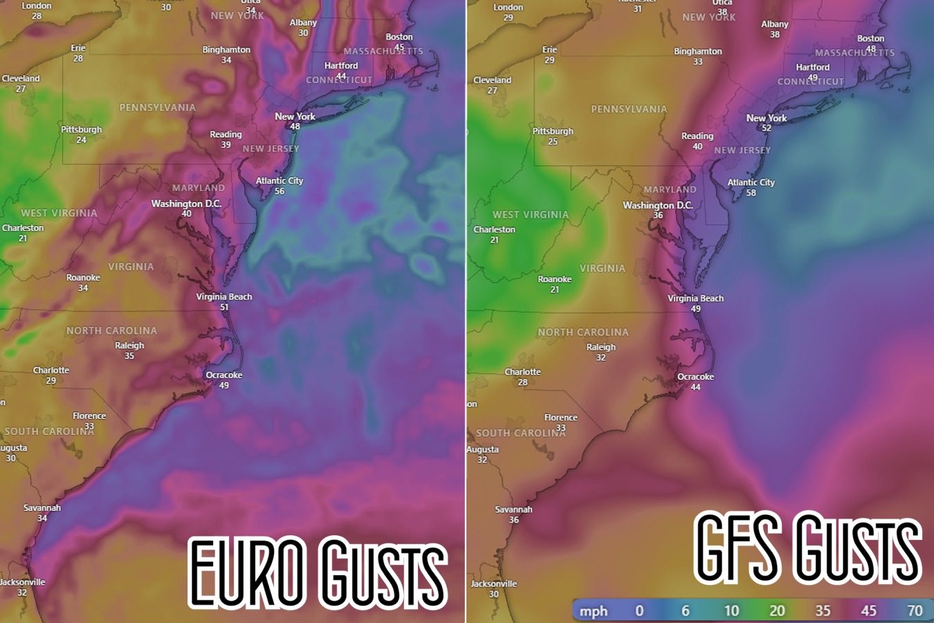
Just an early idea.. but 50 ish gusts pike south and 60 ish 95 south and east . These seem reasonable at this early juncture . Definitely many outages with leaves on trees and any kind of Easterly wind direction component which trees are not accustomed to . And it’s a long duration wind event
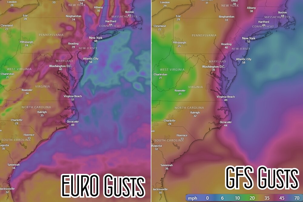
It's interestingly suggestive of the resolution of these two models. The Euro being more discrete tries to expose more precisely where the winds gust higher in the outlook ...notice the elevation with that. The GFS is "fuzzier" with it being less resolved.
-
This was/is always likely to be nothing more than a climo nor'easter. Pretty much just an autumnal raw rainy time of it, swept along by manageable wind. Less than very remarkable in either case. That should be the baseline expectation with this thing. Yeah, that allows a realistic expectation that someone, some how might over-achieve in either measure, but any observation would be the exceptions to the rule.
I still wonder if at the last minute ... a bit of a S contraction in late modeling with less push all the way up. I'm not forecasting that, but I'd be leery of that happening. Either way, the high pressure that's currently parked and giving cause to the current shot across the bow air mass, is retreating due east. SO... it may result less d-drip dose potency than wanted, but your getting a raw east wind whether this thing does that weird oblong thrust up the coast or not.
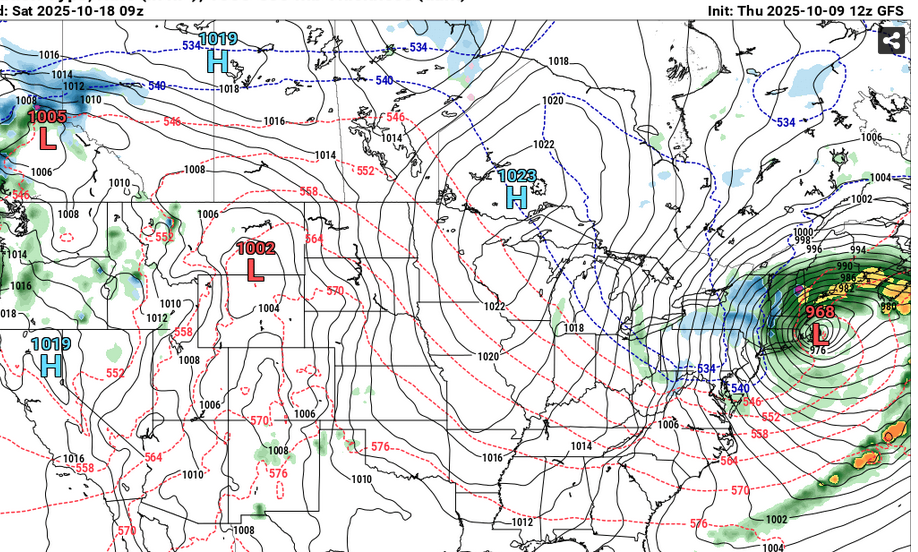
One aspect I'm noticing is just how weak this whole structure is in the H500 evolution. 35 kt jet at 500 mb, parallel offshore the EC doesn't typically inspire all that much. The low pressure is objectively not modeled much lower than 1000 mb - some guidance as low a 995 but the average is higher than that. Even though I said 'climate nor'easter' above, the former is in fact weaker than a climate nor'easter. I'm only giving it that much in deference to that structural anomaly these guidance insist will take place; a bit of an anomalous polarward expansion around the N wall of the cyclone basin.
-
1
-
-
56 minutes ago, CoastalWx said:
Well 18z gfs certainly got wetter lol. Man this storm is all over the place.
Red herring's still on the table

I'm noticing a weakening trend in the H500s that's very subtle over the last 2 days ( look at 18z two days ago and compare it to this run...etc). Eventual if that continues and it this slips below a forcing threshold it's a laugher. It's just not a convincing signal. But sure why not
-
1
-
-
It'll end up being a climo nor'easter in the end. most likely ...
-
2
-
 1
1
-
 5
5
-
-
who needs hybrids when next up on the docket wrought this
-
4
-
1
-

Occasional Thoughts on Climate Change
in Climate Change
Posted
https://phys.org/news/2025-10-seas-cities-coastal-crisis-china.html