

Typhoon Tip
-
Posts
43,363 -
Joined
-
Last visited
Content Type
Profiles
Blogs
Forums
American Weather
Media Demo
Store
Gallery
Everything posted by Typhoon Tip
-
i was thinking about this yesterday as our saturday was being royally porked by this -nao circulation manifold ... (eastern ne) how these -nao's in autumn and spring have been notable in a lag of some 7 to 10 days, post warm anomalies that pervaded the great lakes/ov/ma/ne regions. this happened post those exotic warm ups that occurred in the februaries since 2015, where several of them recorded ... really quite absurdly warm temperature events ( rel to climo). -nao's materialized afterward. when it was 80 to 87 for some 10 days recently from d.c. to pwm - its not the same anomaly, but it was impressive enough. it's really more about the supporting pattern evolution one striking example of this was october 2011, when during the teens of that month it was routinely in the 70s in the I-95 corridor with attending ridging --> -nao a week later... the snow event(s) late that october indirectly related.
-
is it a 'heat wave' or more permanent - marine heatwave phenomenon have shelf lives. this is beginning to feel like something in the scaffolding of the planet do the weight of persistence - just supposition speaking. 2ndly, are we certain that the west pac is why seasons are not behaving : i understand the appeal of finding a silver bullet cause but i'm just as curious that the weird winter thing and the west pac may both be resulting and not necessarily causally linked like that.
-
September vibes - Last 90s for some, 1st frost for others
Typhoon Tip replied to tamarack's topic in New England
this is nice. i wasn't admittedly expecting any sun today but ... we seem to be eroding out the mid and upper level deck with just some cu streets overhead. sat confirms this regionally, too - tho e and berks working on it -
September vibes - Last 90s for some, 1st frost for others
Typhoon Tip replied to tamarack's topic in New England
in fact not only what scott was saying but there's attempt there to park another warm ridge node over the the e mid latitudes -
September vibes - Last 90s for some, 1st frost for others
Typhoon Tip replied to tamarack's topic in New England
Okay ...yeah I remember that too. weird coastal it plunked down in the middle of an otherwise ridge was odd looking. now it's all but gone.. fits what i've been noticing about the erratic -
September vibes - Last 90s for some, 1st frost for others
Typhoon Tip replied to tamarack's topic in New England
what time range are you referring ? - not intending to 'defend' the euro here, but i've noticed that every model has been particularly bad in the mid+ range for a few days now, in this region: just curious cuz they've all been flip-flopping on placement of ridge and trough nodes in that nebular flow region below the appr polar branch, way more so than normal variability for d5-8 range.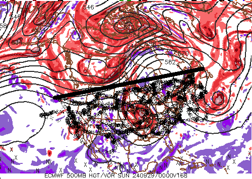
-
September vibes - Last 90s for some, 1st frost for others
Typhoon Tip replied to tamarack's topic in New England
oh we may as well be on a raft bobbing over the flemish cap with this seldom understood reality of marine micro climate here -
September vibes - Last 90s for some, 1st frost for others
Typhoon Tip replied to tamarack's topic in New England
60 was the high here ... spent the integral at 57 -
that really is amusingly calm out there in the mdr. here it is the apex climo or close to it, and huckleberry fin's raft could make it unscathed the entire thousands of miles across the basin ...during a season of predicted epicosity. never gets old! hahaha
-
September vibes - Last 90s for some, 1st frost for others
Typhoon Tip replied to tamarack's topic in New England
we are getting so f'n screwed here in new england. christ it's warmer up in maine. this is three consecutive days where east of the berks and sw of maine has been targeted to host the entire planetary budget for offset cc. if it were not for sne, the world global average would be putting up another temperature surge - -
Occasional Thoughts on Climate Change
Typhoon Tip replied to donsutherland1's topic in Climate Change
the issue with species is that that deltas are happening at a faster rate of change than the adaptation rates. die -offs will commence well before the destiny of the temperatures are realized. autotrophic ( producer ) species are most fragile and foot food pyramids - ... academically, the latter become unstable and ultimately the collapse ecologies follow. mass extinctions -
September vibes - Last 90s for some, 1st frost for others
Typhoon Tip replied to tamarack's topic in New England
man ... smelling the air and watching the slaty gray sky race sw, it's an exact likeness to a spirit killing bd butt f'n -
September vibes - Last 90s for some, 1st frost for others
Typhoon Tip replied to tamarack's topic in New England
there's still 10 days left to muck up impressions of this particular september, though. this morass that's plaguing eastern areas ... marks the decay of that persistence we enjoyed over the last couple of weeks. not clear what the next 10 days will entail, but there's everything from fronts to tropical squirts up the coast, neither of which is being handled very well in guidance ... but all of which are definitely in the possible manifold of reasons to f'ing hate the shit out of this asshole month lol. ... speaking of which, plagued by this garbage the way we are, reminds me of april. albany 80, boston 62 with the harbor sharting right at civility like a roman god's cruelty is classically 'fair' distribution. hahaha -
Occasional Thoughts on Climate Change
Typhoon Tip replied to donsutherland1's topic in Climate Change
pretty solidly damning science/article here... https://phys.org/news/2024-09-earth-global-temperature-drastically-million.html i like this, ".. But greenhouse gas emissions caused by anthropogenic climate change are currently warming the planet at a much faster rate than even the fastest warming events of the Phanerozoic..." we just experience that global t burst last year... it seems entirely intuitive to me - if not likely ... - that the cc temperature curve of the future will feature more of these surges, rather than a cozy predictable and easily adaptive helpful change rate ( lol, but seriously - ) -
GFS won’t give up with the attempt at Sandy cousin if not redux
-
meanwhile ... i'm seeing a winter hemisphere characterized by something between a vestige and an out right rudimentary repeat of the last 6 or 7 of them so there it is. either a seasonal forecast write-up worthy of a dissertation submission, or that statement. to me, as long as either end up with that same principle, both score. lol
-
September vibes - Last 90s for some, 1st frost for others
Typhoon Tip replied to tamarack's topic in New England
how come you don't work there now? - if it's not too personal -
September vibes - Last 90s for some, 1st frost for others
Typhoon Tip replied to tamarack's topic in New England
oz euro still insisting light rain plume penetrates west early tomorrow into the interior ... rotating sw. american models do not - although the nam hints at bvr/strata related moisture. albeit minor, it's an interesting model contest. actually the 06z euro's dry now so... chicken shit model won't play -
September vibes - Last 90s for some, 1st frost for others
Typhoon Tip replied to tamarack's topic in New England
yeah not a good sign for rain-wanters when the nam corrects s-e inside of 42 hours. particularly in the winter, that model's typically nw of all others ... then corrects s-e when in short terms - usually laughing at the storm wieners when it takes the rug and runs away. this thing looks like it's matching that corrective behavior regardless of it being 75 -80 f -
given to the lack of activity to date causing non-dispersion, the ohc over the western caribbean/gulf routes are about as loaded as is physically possible - it's probably not a huge leap to hunch whatever develops down there might become an impressive concern to put it mildly. it's not just the ohc tho. ohc can be extreme - doesn't matter without the other circulation machinery. but that's changing... the erstwhile suppression i myself have suggested, appears to be at long last progressing away from the basin. take the lid off the pressure cooker? the 12z gfs is likely over-amplified - what's new - beyond d7 up north ...but, the advent or emergence of a tc down there can happen independent of the gfs' handling of the westerlies/pattern at mid latitudes. it's from recent guidance i've seen ...about d4.5 is when the region seems to develop from something actually ejected out of s. america which is interesting.
-
there's been events, extreme ones at that, during this last 2 years though flooding may not be everyone's cup of tea, granted. but the vt [seemingly new climate regime] rain bombs, ...the one in leominster and then more recently in ct, were amazing to watch from afar, and to see unfold in real time data/observation tech, nonetheless. don't mean to condescend ( seriously ...) but some of it might be related to 'drama addiction' ? maybe dystopian-drama is more apropos. we've all admitted to a kind of 'rush' felt at the instant of the model's 96 hour forecast ...suggesting the 180 hour might look dramatic - and then watching the movie of the model play out that vibe is some sort of weird satisfaction. endorphin thing, even and gives a fix for excitement. i'm probably going too far with this here ( what's new lol ) but it kind of all goes back to the psychotropic addiction stuff we've brought to light in the past. it was investigated by 60 minutes. it was showcased by 'the social dilemma' ( ex facebook engineers tell-all). folks sort of become ... something like addicted to the specter and emotion of witnessing the world's dirty laundry. these models ( 'cinema' as i like to call them..) sort of tap into that same phenom. and the addiction isn't really a basis from which expectations will ever match reality. that all said, ... yeah we haven't had a 1938 or gloria thing is 30+ years. we haven't had a winter that, forget psychotropic doom scrolling, ...we can't even merely write (dying art) home about either. but there have been things that are out of the ordinary enough. frankly, i dance around the idea that winters may never be what we were raised to see them as.
-
September vibes - Last 90s for some, 1st frost for others
Typhoon Tip replied to tamarack's topic in New England
i know.. 'dry begets dry' i guess -
September vibes - Last 90s for some, 1st frost for others
Typhoon Tip replied to tamarack's topic in New England
this morass down the coast and over the waters s of li is all being generated by a 582 dm close surface/circulation envelope. 582 it's a single contour closed remnant of whatever that thing was that came inland down there the other day. yet it has all this presentation like it's way more. it's always a reminder in this game how much relativity is everything. it doesn't matter that 582 hgts can have 100f at the surface - which makes 64 and rain a very low bar for that metric. or that a single contour is weak by any standard metric or convention, in general so why the big mass. it only matters if the surrounding medium is allowing it to become the dominating force at that time -
September vibes - Last 90s for some, 1st frost for others
Typhoon Tip replied to tamarack's topic in New England
seein' as no one at all asked i'm hoping for a 2-3" basin deal/bust high ...that fades by saturday and the sun's back out by noon. nice sunday follows. -
i was wondering if we might see a week or two late anomaly on that myself, but perhaps that won't be the case. mostly because the indexes seemed to suggest less favorable retention into these first weeks of sept. arctic oscillation going negative in latter august and so forth. it seems sept 7 to 15 is the corner-turning week when looking at that historically. not sure about all years in that but just a cursory look at the curves. that might be an interestingly damning signal at some point in the future. say if some tortured retention year ... then goes on to actually waiting to turn the corner until a couple of weeks later. - the ultimate threshold crossing, so to speak. the thing is, on sept 15 the sun is crawling along the horizon at the geo n pole. by this sunday morning, it's twilight there. it's not a huge intuitive leap to guess why sept 15 tends to formally end the melting, when talking about ssts of 32 F losing solar input at that time. so in a sense, that should leave some combination of the background climate, together with whatever pattern anomalies and heat transporting in, as the remaining forcing for any such extension of melting. so if it were belated and the pattern isn't as obviously culpable ..well that doesn't leave much else and that would scream a threshold. hell, if nothing else, good science fiction. lol


