Typhoon Tip
-
Posts
43,363 -
Joined
-
Last visited
Content Type
Profiles
Blogs
Forums
American Weather
Media Demo
Store
Gallery
Everything posted by Typhoon Tip
-
yeah .. full disclosure, i know this thread was mainly "experimental" - and it was ... but, about mid way since i was admittedly more thinking something other than complete bullshit for this effort, too - thing is, we all know the index numerology/projections therein are made more useful by then looking at the spatial aspects of the super synopsis. hugely important to this latter facet, understanding/detecting subtle trends. one of which has been this Auschwitzian dental exam of a western ridge - never seen a +2 delta pna move be so non-committal to a western n/a ridge like this before. i'm wondering if speed in the flow this... or more phase 5 mjo that... i don't want to instill hope, or add to the seemingly problematic d-drip mania problem with this social media engagement ... ( lol ) but, this keeps reminding me of the Boxing Day storm back in 2010's, great cosmic dildo winter for specifically Ayer, Ma ... (eh hem) that storm was essentially dead and vanquished from the charts over a great initial look at like d8, too. with just 42 or something hours to go ... it came all the way back to deliberately give me, personally, 2.4" of arctic dust while ingrate trolls that didn't deserve it were rewarded with blizzard b.js yeah... heh. anyway, modeling standards really have steeply improved a lot in the last 12 years - not sure that is happening quite the same here. we are not seeing a complete loss from the charts. the vestiges of "should" happen/suggestions are still there. so if it comes back stronger in the short game, it won't be so drastic but this has been a really, really lousy drug supply. i say we switch dealers!
-
but in deference to all ... all models did exceptionally well with that - at least as far as my memory aligns. that may not have been anything particular to euro skill, but more having to do with just the uniqueness of that hemisphere at the time. unique situations tend to have overwhelming physics that tend to dominate the field while they are passing through out in time ... that's why "Sandy" and "Superstorm, 1993" and on and on, were detectable quite far out in the guidance and became eerily confident from a long way off ...unlike this giant piece of f'ing shit
-
... the forcing arrives from the pac - that induces the tpv descent ... just sayn'
-
new gfs right off the bat this run has a 00z chart
-
it's interesting this model handling of the +d(pna) expression across the continent has been getting pancaked ( latitude squeeshed ) as an ongoing battle. it really smacks like the the phase 5 mjo has more play in forcing a lower frequency transmission
-
for 144 hours ... maybe this will be different, but from my experience ... when the 00z ggem, 00z gefs, 00z ecm blend looks the way it does at 6 days, best case scenario typically results in yeah.. you get something out of it but it ceilings a middling/pedestrian event. i do see the 18z to 00z to 06z large continuity breaking as a red flag - maybe there is a bigger event being masked by modeling ineptitude. i dunno
-
hm sufficed it is to say … this is going to morph in future runs. that’s an unlikely stall position up there east of Freeport maine when that structure so deep and cutting off over ne PA The problem with this run was that it didn’t have quite enough dpva as it was first amplifying so that the low took too long to get started but if we just get a little bit more dpva earlier on in that sequence and all that ends up over block Island
-
This is just about where we want this to look like at 168 hrs
-
yeah, i'd stick with the multi member plots, Ray -
-
there's a subtly there that is important imo the strongest solutions are biased on the left side of that 'inner spread' region. i'm pretty sure those members, vs the outer/weaker ones ..., are in conflict over the degree of deep layer meridian character there is to the circulation mode at this time.
-
i know what you're saying ... i'm not talking about the concept of being in a good position at this far out in time... i'm just comparing the eps ens that i provided above, to that scalar gefs... the latter is clear whiff as is. the comparison is interesting
-
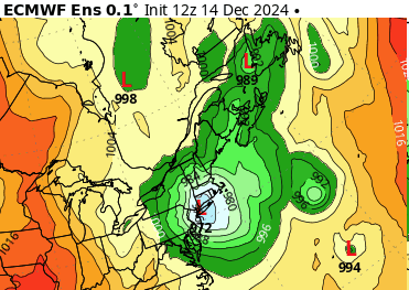
impressive compared to the utterly non-existence portrayed by the gefs ... this below is a 972 low tucked into the bite region of ny, with a ton of cold air over alb-lower 'hampshire ... it's probably mix contention eventually but this probably is a lot of snow/wind prior...
-
this euro run is suspect beyond 120 hours for me. the ridge barely progressing e, off an approximate 100 to 110w longitudinal axis, yet the s/w's are racing e and stretching the flow like that - mm it's more likely those s/w slow down. not sure about amplitude and what that means as far as any cyclogen, but that former practice is suspect.
-
i was looking at the ggem? - sorry you guys might have been gfsing
-
ha! i'd trophy case the 156 ggem's 500 mb heights and sfc
-
that's the one we're supposed to be following ... this 19/20th's n/stream bullying in routine is new... we're still not completely shedding the wave space contention problem, in addition to the western ridge stuff... altho there may be a relationship.
-
fwiw - ggem looks better comparing interval 132 hrs to 144 from 00z
-
might have to "boxing day bomb" this thing
-
Thanks, Will ! ...i was looking things over and wondering oh no, what kind of damage control is it gonna take in here this morning... so, i was going to tell folks that the EPS (and GEPs both actually ) were not only fine for 170+ hours, but actually trended better, too - low and behold, we can always count on you lol yeah, i also want to add that the last 2 cycles of the operational guidance regressed on the western ridge amplitude. it's not even subtle. it's on the order 6 to 10 dem through the arc axis. quick example, set this recent 18z gfs next to the 00z gfs, and compare the ridge amplitude. bigger western ridge, more digging in the east. i don't know if that is going to all be the case, but something is neg interfering with the western heights at a larger scope/picture. it may be the the phase 5 mjo - tho it is not a pattern maker, it is a pattern modulator. so its contribution really shouldn't be ignored entirely. it can be overcome. this isn't the first rodeo with western heights not cooperating in the late mid range, either.
-
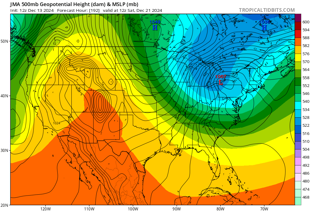
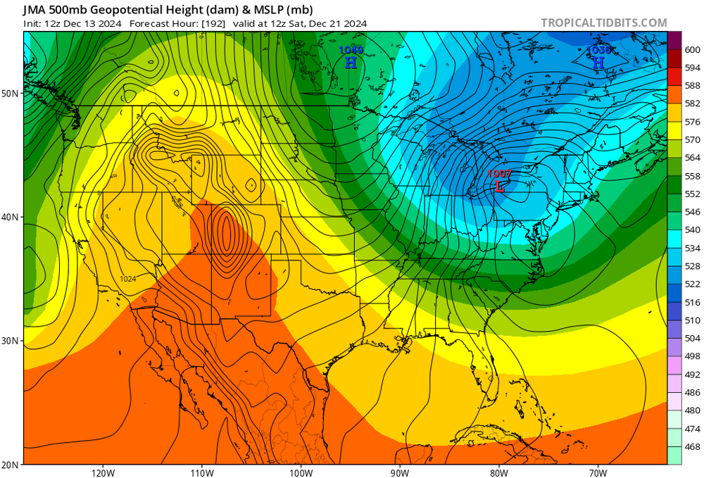
For what it’s probably not worth to anybody… the jma model was about to detonate a very intense northern stream bomb. the model just doesn’t quite go out far enough, but if you extrapolate this, that’s what you’re gonna end up with
-
ha... i was just telling prismshine ? i was just tell that poster that the gfs may yet surge the ridge - you know, it might help if i actually go look at the gfs run now, huh ..it a'ight .. that chart makes the point well enough
-
it's like the gfs is trying to predict the ayer ma gravity gyna wedge
-
i don't think it does 'completely' ... it may reduce and still play a role, too in fact, i'm still not entirely happy with the scaling of the western ridge as the d(mass field) doesn't appear to satisfy the +d(pna) forcing. that's code for it should be bigger. the ens means of the euro and to some extend the GEFs have been routinely better formed/fitting. the operational runs may yet surge that more... then, it's not impossible that the operational models be destined to a subsume phasing. that's when you have a southern wave - not necessarily the same as a subtropical jet born disturbance ...but just a wave s running underneath...; upstream ridge burst forces the n/stream to 'tuck' a powerful diving jet into the backs side of s system, and it's much more mechanically powerful wave by virtue of planetary aspects - it's like a black hole devouring a stellar object: the former eats the energy and becomes that much stronger. i love space metaphors ...haha. but in doing so, a monster is born and there's little to no trace of the original s wave left on the charts... just a deep low taking liberties writing there - i'm not saying this is a subsumer, but anytime i see a s wave eject and that upstream ridge surge forcing a n/stream to dive like that, that is precarioius
-
a trend that i mentioned to you a couple hours ago when describing the euro evolution. so we have both guidance heading toward committing on the 22n instead of the 20th... which preferentially in these index correction events, there is more typically going to be one restoring event... if the pattern reloads, that's when you get your repeating maintenance/sub-index scale type fun - but that's for later on if need be Euro: "the first is the lead wave more focused on the 20th is weaker by a factor of 2 (est)... it's smaller and less deep compared to the 00z per intervals as it runs out ahead. the second aspect that leaped out is the wave spacing between the 20th and the second opening up in the 12z compared to the 00z... bigger gap in other words if the lead (20th) continues to attenuate then as Will pointed out, there's less b-c escape which of course services the latter amplitude. "