CryHavoc
-
Posts
255 -
Joined
-
Last visited
Content Type
Profiles
Blogs
Forums
American Weather
Media Demo
Store
Gallery
Everything posted by CryHavoc
-
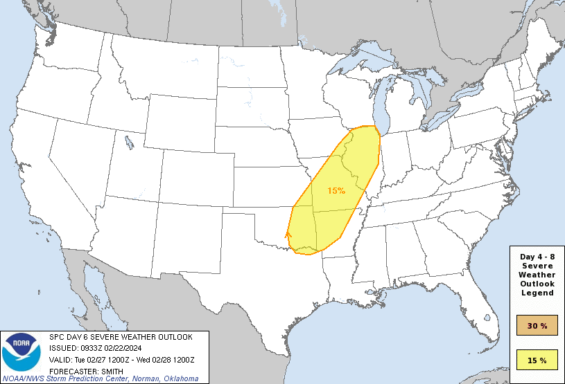
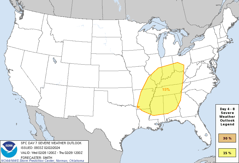
Surprised there isn't a thread on this already. This has the makings of a pretty serious early season outbreak, with an extremely vigorous trough digging into the Midwest starting early next week. Some of the ingredients are already lining up, models look like there is adequate consensus, moisture return looks incredibly rich. I've seen estimates for the low as far down as 985mb. That D7 is probably the largest 15% contour for a full week out I've ever seen, although some of the early model runs look like D6/Tuesday might be the main event. Ominous setup either way. Still plenty of time to bust, but I wouldn't bet money on this one going without some notable sigsvr action.
-
S&R is still ongoing as well.
-
Absolutely catastrophic damage on the News 9 stream right now.
-
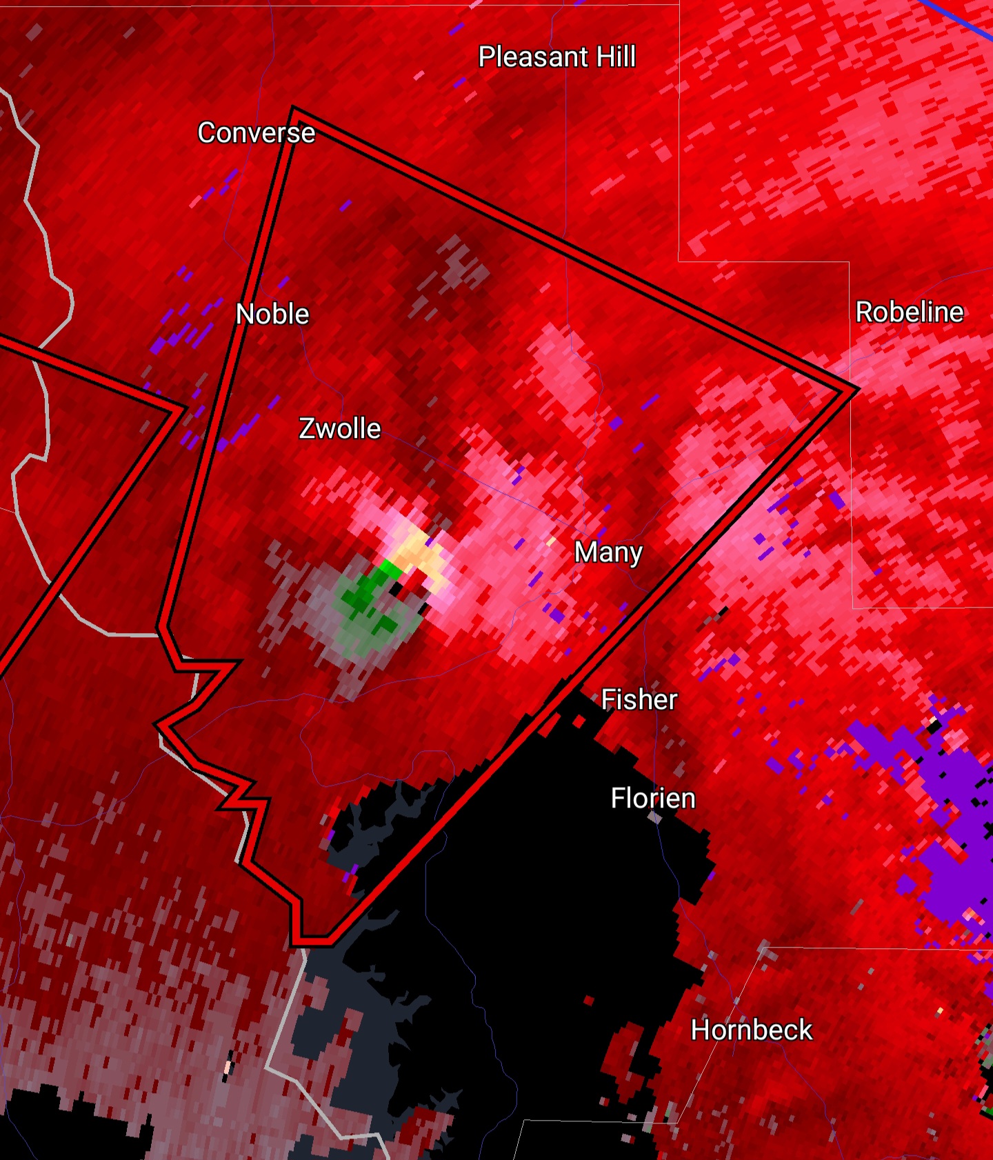
Robust hooks already showing on radar.
-
Devin PItts chasing.
-
First PDS watch is now active.
-
That might be the largest d5 30% I've ever seen.
-
Severe Weather 3-23-23 through 3-26-23
CryHavoc replied to cheese007's topic in Central/Western States
-
Severe Weather 3-23-23 through 3-26-23
CryHavoc replied to cheese007's topic in Central/Western States
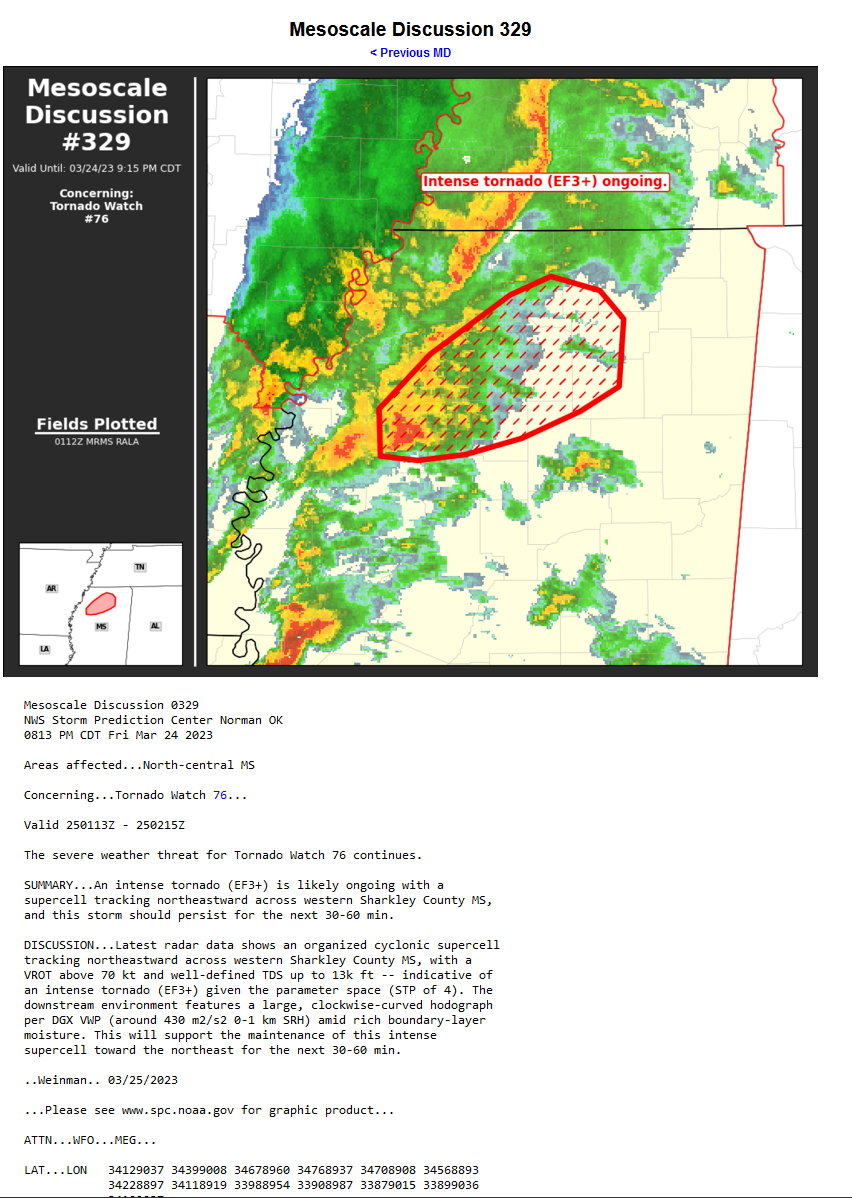
https://www.spc.noaa.gov/products/md/md0329.html
-
March 2nd Moderate Risk ArkLaTex
CryHavoc replied to Ed, snow and hurricane fan's topic in Central/Western States
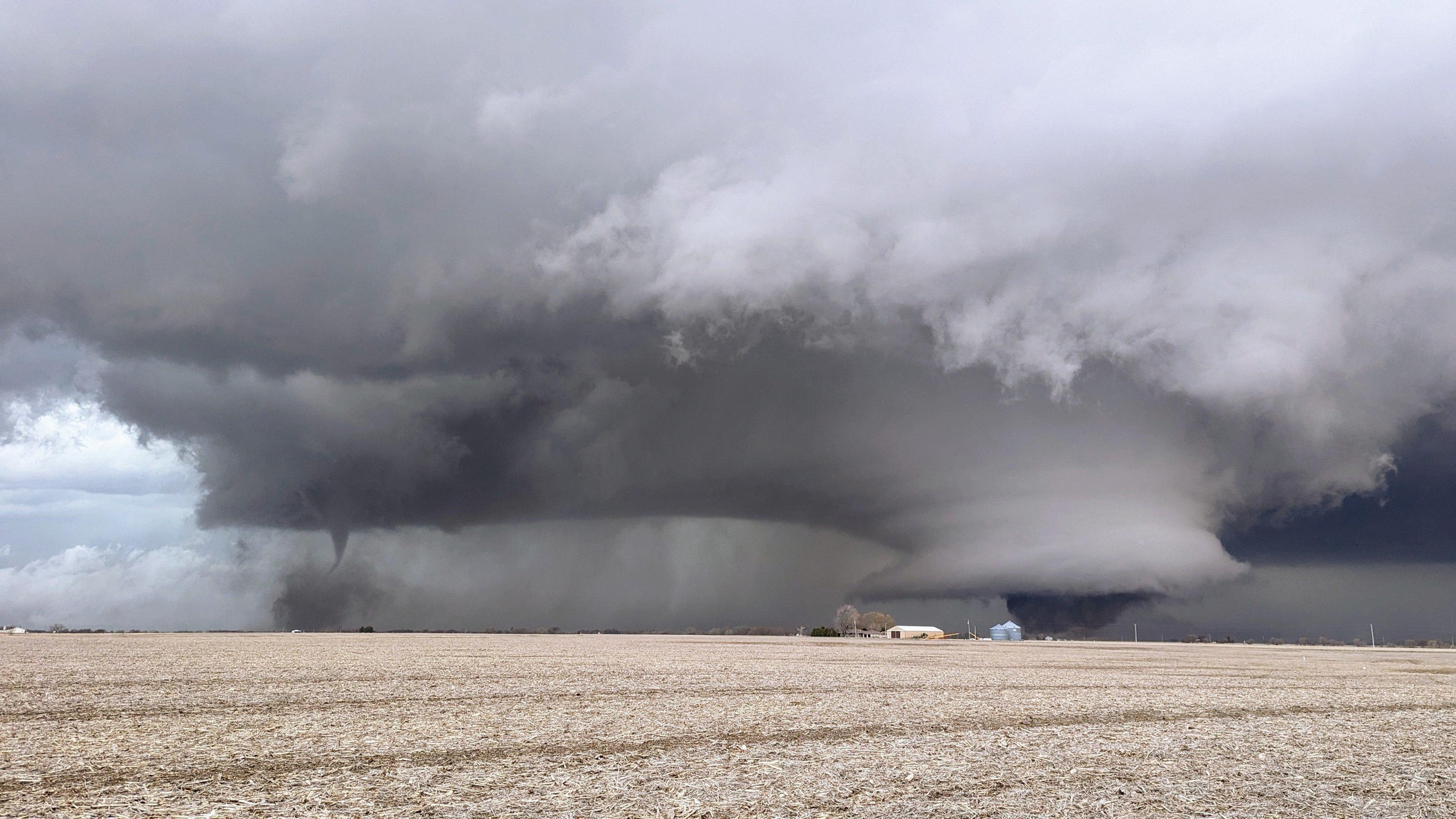
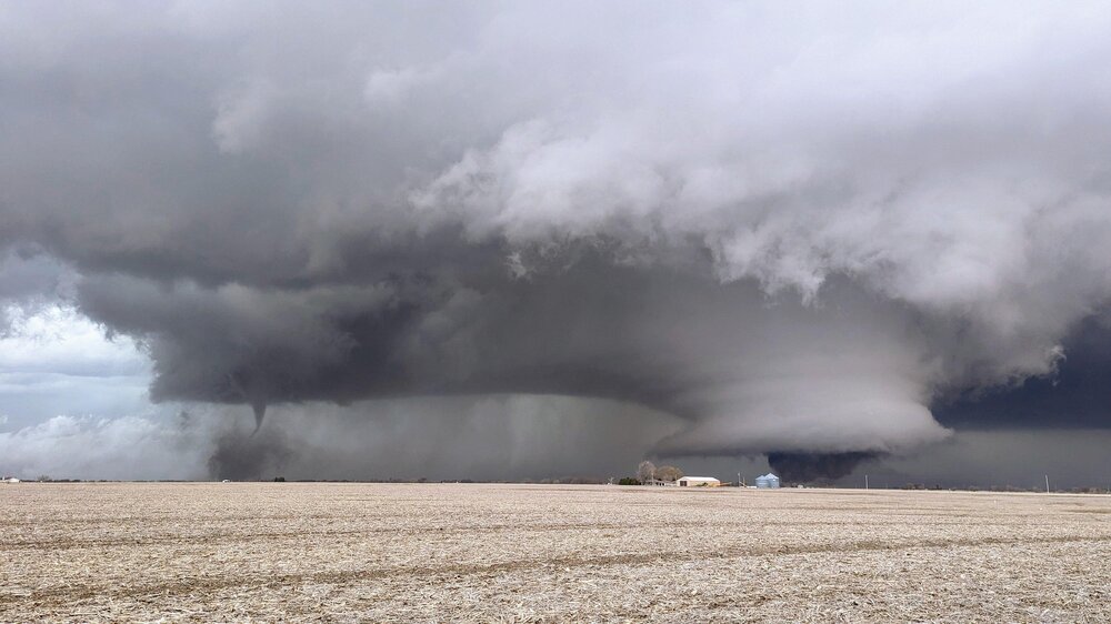
Look at this beast!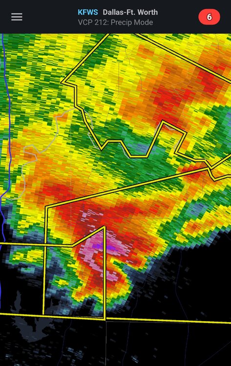
-
March 2nd Moderate Risk ArkLaTex
CryHavoc replied to Ed, snow and hurricane fan's topic in Central/Western States
Ominous wording from the SPC. I would guess the Day 1 issuance will stay MDT at this juncture. Seems to be enough questions around the timing and shear to make a high risk somewhat unlikely. -
February 15-16 potential severe weather events
CryHavoc replied to DanLarsen34's topic in Central/Western States
Wow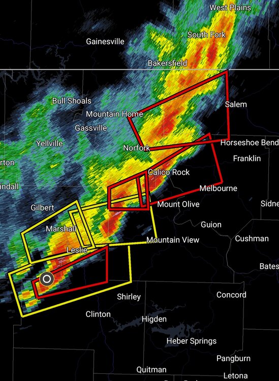
-
Checking in. Over 14 inches of rain have fallen here in the past week. We had some thunder, lightning, and even some mesos forming over the bay area today. Had two rounds of pea sized hail here. Flooding is a major concern in many areas, thankfully my locality is in good shape.
-
Latest forecast disco is out: Next message to convey is resiliency as this will not be a "one and done" storm. Details are still hard to pinpoint but resounding message is several more storms look to be lined up for this weekend, into next week and towards MLK weekend. The cumulative effect of these storms could be quite debilitating. At this time we expect Friday to be a relative break in the storms day. (i.e. dry). Next storm looks to arrive Saturday into Sunday and it does look to have AR characteristics with high moisture plume. Current timing would bring a break later Sunday into early Monday with yet another moderate to strong AR possible later Monday into Tuesday of next week followed by a brief break and another system towards the end of next week. Of course timing and details will change but the theme remains the same. A storm train of systems looks to march across the Pacific and impact much of NorCal through at least next week and possibly through MLK weekend. It's noted that the operational gfs runs out through Jan 19th show precip chances. ___ All bay area residents are being advised to prep for evacuation, even for areas that are not flood/ff prone. It's hard not to be worried given the strength of these systems. Give me comparatively tiny tornadoes any day to these behemoth systems that just dump inordinate amounts of water everywhere for days and days at a time.
-
The national weather service for the bay area just released the most recent disco, and they're using some... Concerning language. >To put it simply, this will likely be one of the most impactful systems on a widespread scale that this meteorologist has seen in a long while. The impacts will include widespread flooding, roads washing out, hillside collapsing, trees down (potentially full groves), widespread power outages, immediate disruption to commerce, and the worst of all, likely loss of human life. This is truly a brutal system that we are looking at and needs to be taken seriously.
-
January 2nd and 3rd Severe Weather Threat
CryHavoc replied to DanLarsen34's topic in Central/Western States
Tornado warned storm is moving into the Mayfield KY area. Ugh. -
January 2nd and 3rd Severe Weather Threat
CryHavoc replied to DanLarsen34's topic in Central/Western States
Yeah, I always find it incredible on days when even tiny cells start to spin before they even have supercellular characteristics. And then other days you have massive motherships who won't put down a tornado. -
January 2nd and 3rd Severe Weather Threat
CryHavoc replied to DanLarsen34's topic in Central/Western States
Couplet is absolutely raging.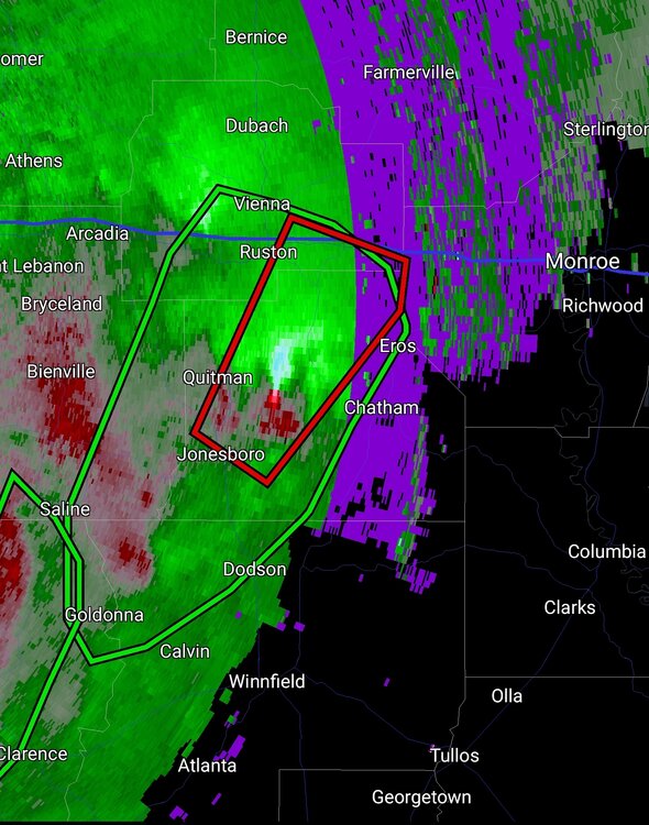
-
January 2nd and 3rd Severe Weather Threat
CryHavoc replied to DanLarsen34's topic in Central/Western States
PDS tornado warning just NE of Jonesboro Arkansas. -
January 2nd and 3rd Severe Weather Threat
CryHavoc replied to DanLarsen34's topic in Central/Western States
Brandon Copic has been involved in a car wreck. I think he's okay. -
January 2nd and 3rd Severe Weather Threat
CryHavoc replied to DanLarsen34's topic in Central/Western States
Nasty cell here, that couplet is easily the most intense of the day. Tornado warning on the storm.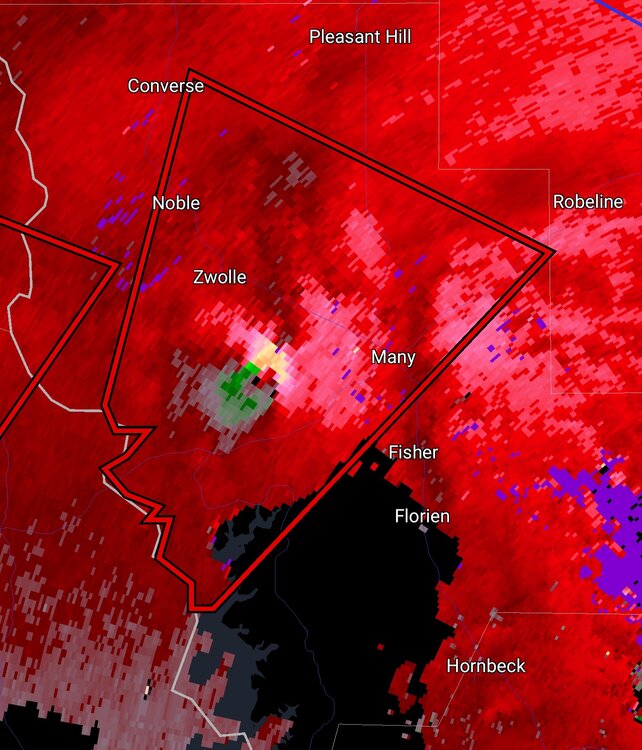
-
We just experienced roughly 85 hours of nearly non-stop rain in the North Bay Area. Ground is completely saturated and localized flooding has been relatively intense. The volume of water here is absolutely impressive. A small stream in my yard that is dry most of the year is loud enough to hear from 100+ feet away. Have measured 7.84" of rain in the last 3 days. Today is supposed to be a respite, but the next 6 days are all projected to have rain with some periods being very heavy. Definitely concerned about mudslides here as well as generalized flooding. Yesterday 4 different roads in the Tahoe area was shut down, and driving anywhere was a nightmare. Will report back as the rains resume tomorrow.
-
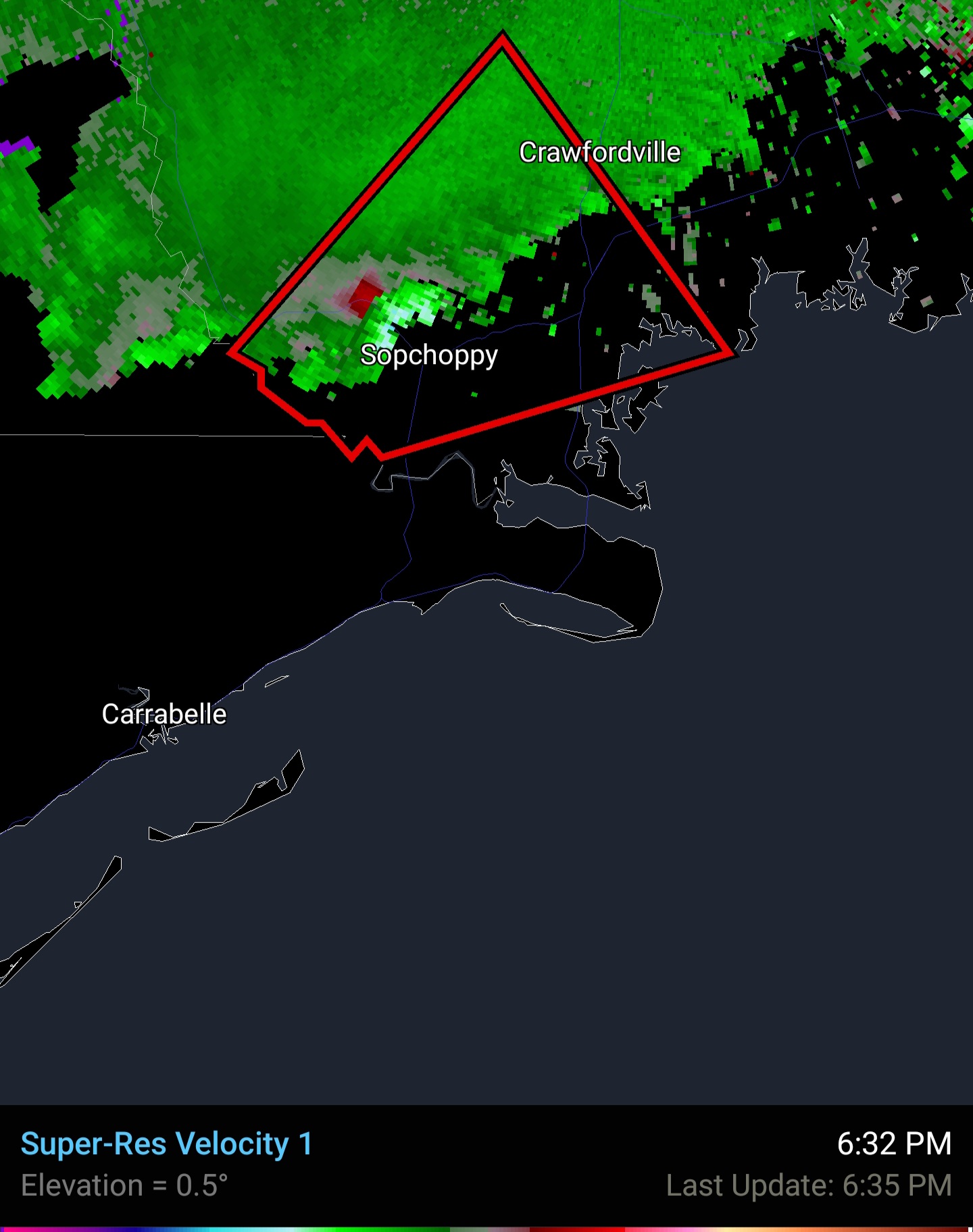
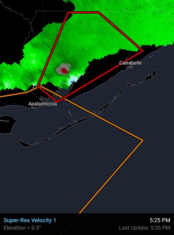
A cell in Florida has been raging for over an hour now with a strong couplet most of that time. Check the time stamps.

-
https://v.redd.it/c8zkck8utx5a1 Video from reddit Sorry, vid has been deleted. Found it again!
-
Tornado emergency issued for NOLA metro.