CryHavoc
-
Posts
255 -
Joined
-
Last visited
Content Type
Profiles
Blogs
Forums
American Weather
Media Demo
Store
Gallery
Everything posted by CryHavoc
-
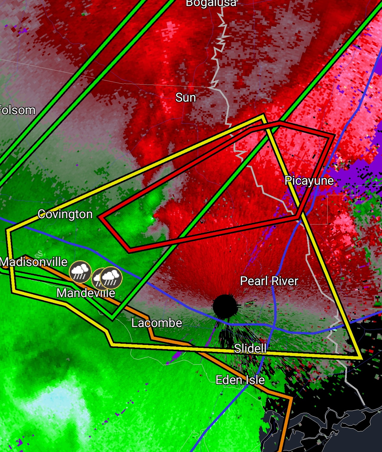
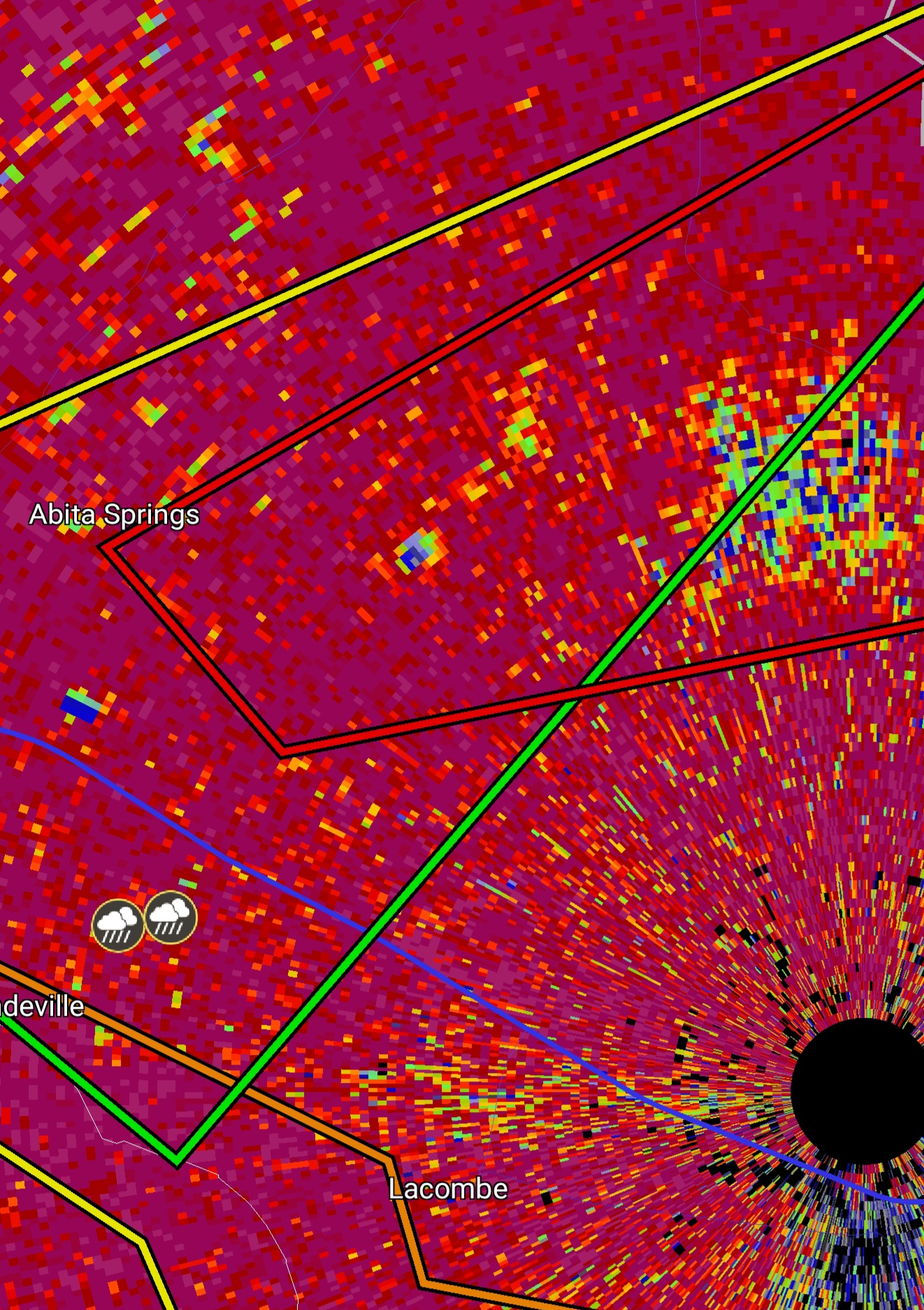
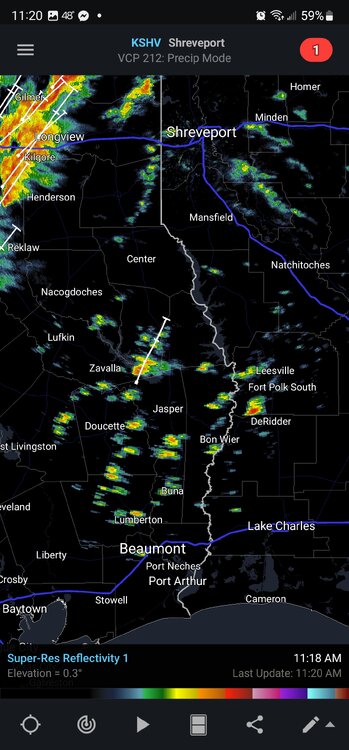
 TDS in extreme eastern Louisiana
 -
Looks awfully worrisome for SE Louisiana over the next few hours.
-
Confirmed TOR on the ground in St. Charles LA. About to move over water. Also a couplet now has a warning in Alabama.... that storm is heading for Tuscaloosa.
-
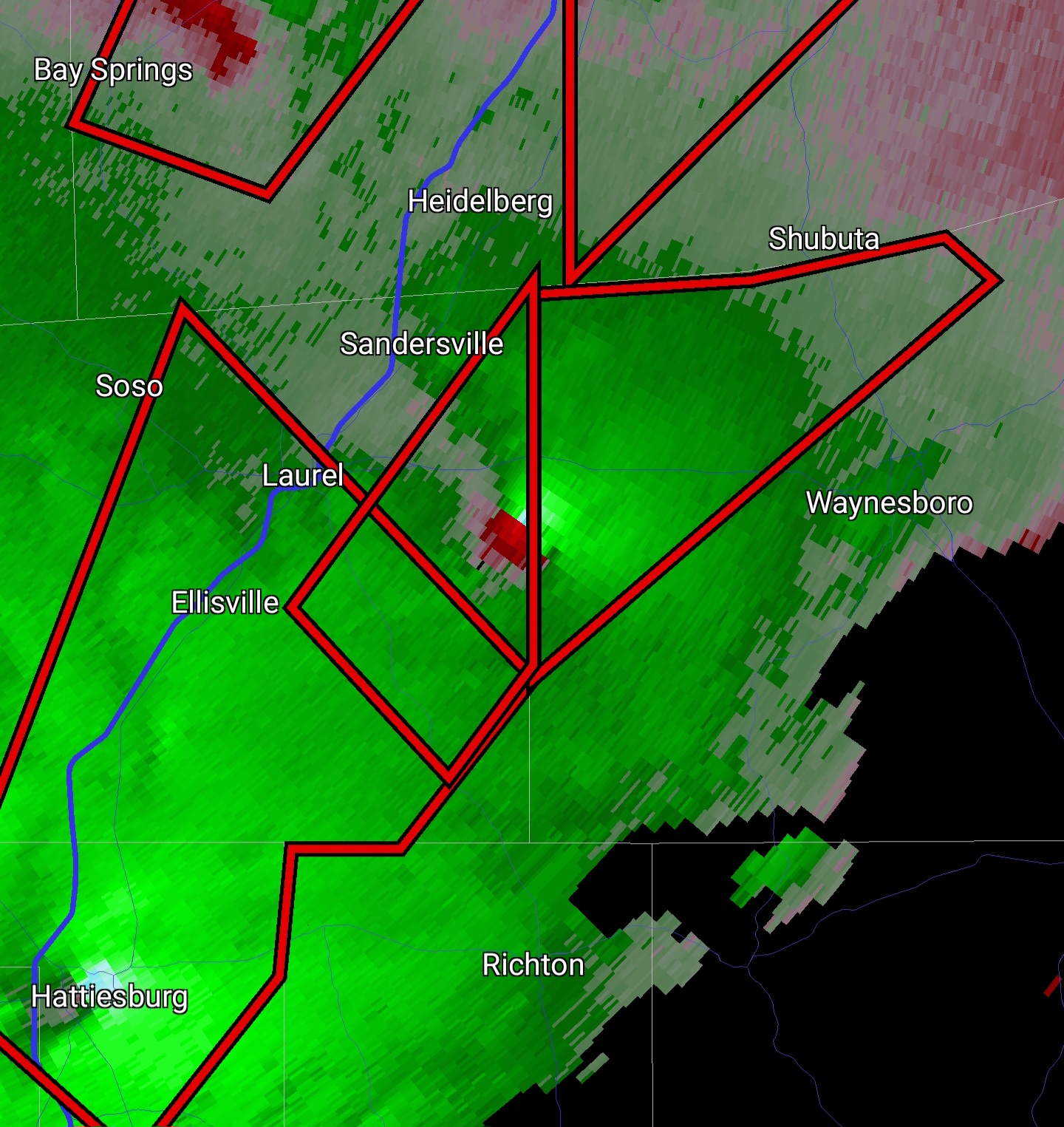
Nasty couplet sw of Shubuta

-
Mesoscale Discussion 2032 NWS Storm Prediction Center Norman OK 0120 PM CST Wed Dec 14 2022 Areas affected...Southern MS...Southwest AL...Eastern LA Concerning...Tornado Watch 588... Valid 141920Z - 142045Z The severe weather threat for Tornado Watch 588 continues. SUMMARY...The threat for strong, long-track tornadoes continues. DISCUSSION...Regional radar imagery continues to show numerous discrete supercells, including a few which have rotational velocity around 40 to 50 kt. The overall environment remain very conducive to tornadic supercells with ample low-level moisture and buoyancy in the presence of strong low to mid-level flow. Recent KLIX VAD data shows increasing winds in the 1-2 km layer. This increase is likely due to a mesoscale low-level jet, which is expected to move northeastward across far southern MS and into southwest AL over the next several hours. Attendant strengthening of the low-level shear within this corridor could augment the already favorable conditions. Surface observations also numerous gusts of 25 to 30 kt across southeast LA. Additionally, ongoing storms will likely strengthen as they approach and interact the warm front, which now extends from about 50 miles northwest of MEI southeastward to south of GZH in southern AL. In all, the threat for strong, long-track tornadoes will continue for at least the next few hours across eastern LA and southern MS, eventually reaching southwest AL later this afternoon/early this evening. ..Mosier/Hart.. 12/14/2022
-
Cells are staying discrete and also looking really worrisome.
-
Nasty looking cells developing here.
-
CC Drop still on that storm over Waskom/Greenwood, looks possibly violent with a large base of rotation.
-
PDS TOR on the storm approaching Waskom/Greenwood.
-
These small cells bear watching.
-
Interesting that the entire enhanced region is also 10% hatched for tornadoes. Not sure how common that is for "just" enhanced on a day 2, but I wouldn't rule out a late d2 MDT or early day 1 mdt with some strong wording being issued on this. Agree with you Quincy, it'll be interesting to see if storms have enough to fire out ahead of the frontal boundary. Seems like a situation where either they won't and we'll have a pretty marginal threat for embedded TORs, or they will and we could see a really rough day of activity. Given the projected hodos I think any cell that really starts building strength and breaks the cap is going to be pretty concerning.
-
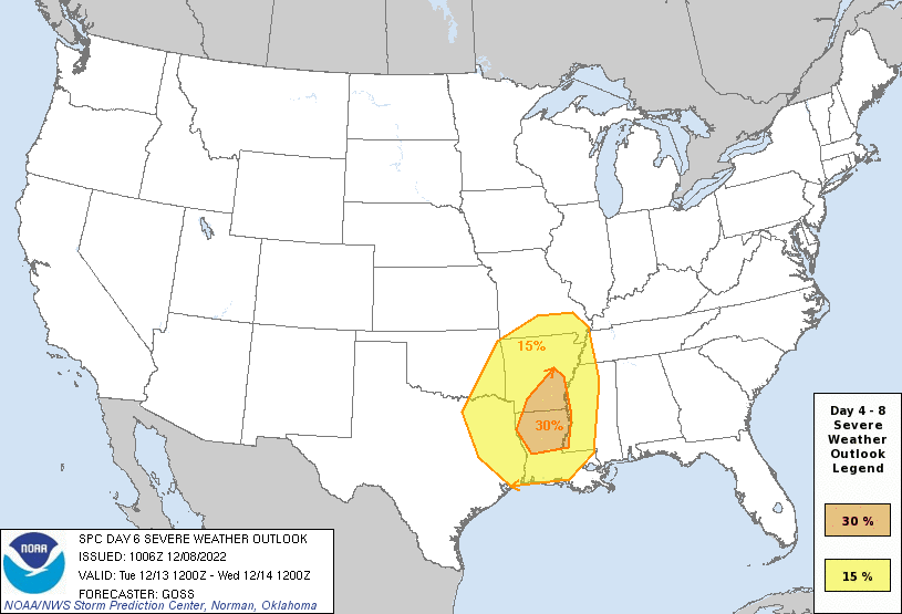
...DISCUSSION... Medium-range models appear to remain solidly consistent -- both in terms of similarity with each other in the most recent run, and also with other, previous runs over the prior 48 hours -- through Day 6/Tuesday Dec. 13. Days 7-8, differences in evolution of the large upper cyclone over the central U.S. lead to differences in timing of surface frontal advance/evolution across the Southeast, with uncertainty thus precluding assessment severe risk beyond Day 6. During the first half of the period, when models are in remarkable agreement, severe risk is expected to gradually increase, from negligible at best (Day 4/Sunday), to increasing over the Oklahoma vicinity Day 5/Monday, and through what is expected to be substantial potential Day 6 from eastern portions of the southern Plains to the Lower Mississippi Valley. The event should begin overnight Monday and into early Tuesday, focused on the Oklahoma vicinity, as a deep upper low crosses the Rockies through the day, and then the central/southern High Plains overnight. This upper low progression will be accompanied by a mature surface low that should shift out of the central High Plains, while a trailing cold front crosses Texas/Oklahoma overnight. Strong southerly winds ahead of the front will result in an increase in low-level moisture -- and thus modest destabilization. Despite the unfavorable time of day, very strong/favorable flow aloft accompanying this system suggests an increase in all-hazards severe weather through the latter stages of the period. Later on into the day on Tuesday (Day 6), continued eastward advance of the deep upper cyclone, and an occluding surface low over the Nebraska vicinity, is expected. As the cold front continues eastward across the southern Plains and into the Ozarks/Arklatex, high theta-e low-level air and modest heating should yield ample CAPE -- particularly across Louisiana and into Arkansas during the afternoon. With a very strong/veering flow field with height that should prove quite supportive of severe/supercell storms, risk for tornadoes is apparent, along with damaging winds and hail. This risk will shift gradually eastward in tandem with frontal advance, likely crossing into the Mississippi and western Tennessee vicinity into the overnight hours. While convection, and some severe potential, should continue spreading eastward/southeastward, increasing uncertainty precludes delineation of a Day 7 area at this time. ..Goss.. 12/08/2022
-
Monday still looks like an active overnight event, but models are starting to come into agreement that Tuesday looks like an increasingly concerning day of potential. SPC has just issued a 30% day 6 watch.

-
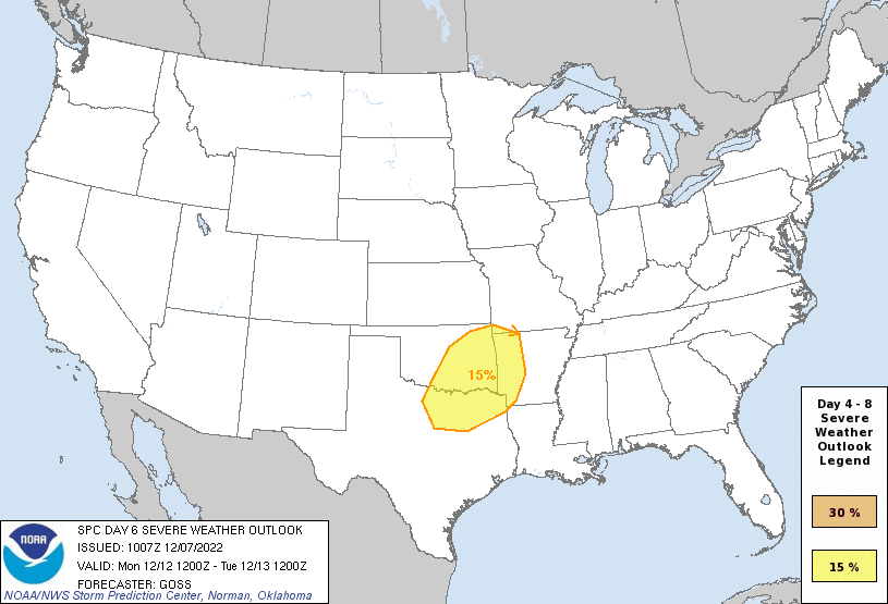
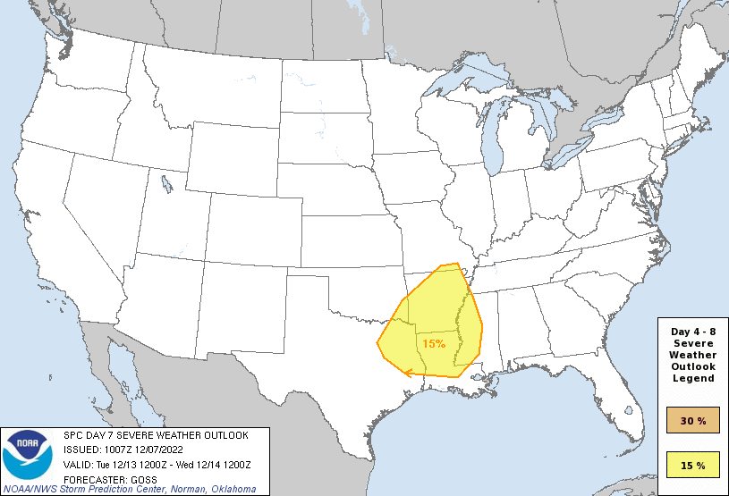
...DISCUSSION... A increase in divergence of solutions amongst medium-range models, and an increase in ensemble spread, is noted as compared to 24 hours prior, along with a general slowing of the advance of the western U.S. trough. In general, models forecast a very gradual amplification of the flow field Days 4-5 and into Day 6, as short-wave energy digs south-southeastward in the vicinity of the western North America Coast Day 4/Saturday, and then begins to pivot a bit more southeastward into the western U.S. Day 5/Sunday. On Day 6/Monday, a more eastward advance of a large closed low will commence, with pronounced height falls reaching the central and southern Plains -- particularly through the evening/overnight hours. This eastward advance appears likely to be accompanied by strong central High Plains cyclogenesis, with a cold front to advance into (GFS) or across (ECMWF) the southern Plains region through the second half of the period. Based on this current pace of advance of the synoptic features, most of the severe risk Monday would appear to exist after dark, spreading across parts of eastern Oklahoma and North Texas, and possibly (per the ECMWF) into western Arkansas. Given favorable northward advection of high theta-e air, and very strong deep-layer shear, all-hazards severe potential would be expected. Continued advance, and additional deepening, of the upper low is expected Tuesday/Day 7, with the surface low progged to occlude over the central Plains and a cold front to sweep eastward to the Mid Mississippi Valley region after dark. With a moist warm sector likely to reside across East Texas/Arkansas/Louisiana in this scenario, and given the very strong wind field accompanying the intensifying synoptic features, all-hazards severe risk including tornado potential would exist. By Day 8, model differences increase, casting additional uncertainty into the forecast. With that said, it does appear that much more limited moisture/instability will exist ahead of the system -- in part due to a strong antecedent ridge of surface high pressure. As such, a diminished severe risk would appear to exist for Day 8. ..Goss.. 12/07/2022
-
Of note, I believe that these are also the 1st and 2nd day 7 outlooks ever issued with 15% for the month of December. A lot could still change, but this is ominous nonetheless.
-
Yet another wave pushing in with a high degree of model consensus this far out means we're once again seeing a 15% region introduced on day 6 and day 7. Day 7's outlook is notably large, covering nearly all of Arkansas, most of Louisiana, and the W half of MS. Has to be one of the largest day 7 regions I've ever seen issued.
-
11/29/22 MDT Outlook Issued -- Regional outbreak possible.
CryHavoc replied to CryHavoc's topic in Central/Western States
"a long tracked and intense tornado may occur' -
11/29/22 MDT Outlook Issued -- Regional outbreak possible.
CryHavoc replied to CryHavoc's topic in Central/Western States
.gif.794b222b4b9e8abb5b4cf295fc7d0fc6.gif)
-
11/29/22 MDT Outlook Issued -- Regional outbreak possible.
CryHavoc replied to CryHavoc's topic in Central/Western States
New update seems to have pushed the mdt a bit east, consistent with recent model trends. I would be surprised to see this go high for day1 based on the probabilities indicated but it certainly cannot be ruled out at this point. -
11/29/22 MDT Outlook Issued -- Regional outbreak possible.
CryHavoc replied to CryHavoc's topic in Central/Western States
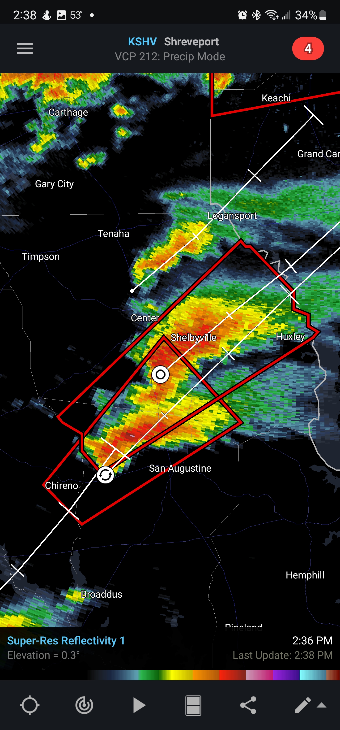
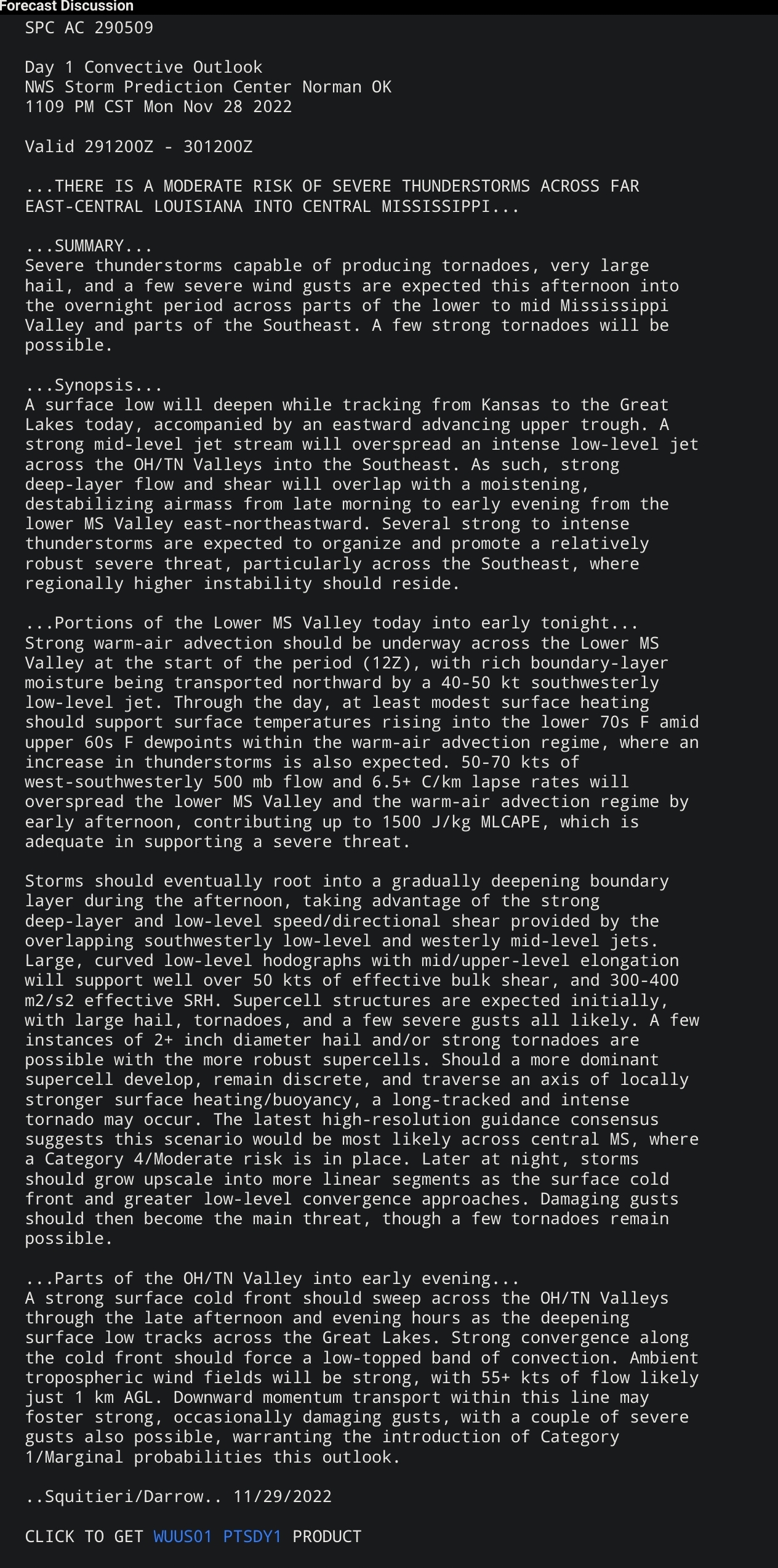
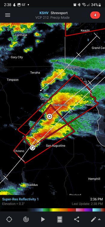
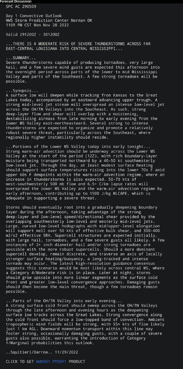
Unfortunately this seems to be a situation of increasing importance/alarm for the deep south. Valid 291200Z - 301200Z ...THERE IS A MODERATE RISK OF SEVERE THUNDERSTORMS ACROSS PARTS OF FAR NORTHEAST LOUISIANA...FAR SOUTHEAST ARKANSAS...NORTHWEST MISSISSIPPI AND FAR SOUTHWEST TENNESSEE... CORRECTED TO KEEP SIG LINE FOR TORNADOES INSIDE 10 PERCENT CONTOUR ...SUMMARY... Severe thunderstorms with tornadoes and wind damage, along with some hail, will be likely on Tuesday afternoon and evening, extending into the overnight period across parts of the lower to mid Mississippi Valley. Significant and/or long-track tornadoes will be possible. ...Regional Tornado Outbreak Possible Tuesday Afternoon and Evening Across Parts of the Lower to Mid Mississippi Valley... ...Lower to Mid Mississippi Valley/Sabine River Valley/Western Ohio and Tennessee Valleys... A progressive upper-level trough will move quickly eastward across the Rockies Tuesday and into the Great Plains. Ahead of the system, a moist airmass, with surface dewpoints in the lower to mid 60s F, will advect northward across the lower and mid Mississippi Valleys. Thunderstorm development will be likely during the day on the eastern edge of the most airmass, from the central Gulf Coast states northward into the western Ohio Valley. While elevated, an isolated severe threat will be possible with some of this convection. Further to the southwest, an axis of moderate instability is forecast to develop by mid to late afternoon from northwest Louisiana northeastward into far eastern Arkansas. This airmass should continue to destabilize during the evening, as rich low-level moisture streams north-northeastward, with MLCAPE reaching the 1500 to 2000 J/kg range by 03Z Wednesday across parts of northern Louisiana, southeast Arkansas and northwest Mississippi. Surface-based convective initiation appears likely to occur during the late afternoon and early evening in northern Louisiana, with these storms tracking northeastward across far southeast Arkansas and into northwest Mississippi. Throughout the day on Tuesday, deep-layer shear will steadily increase across the region as a 70 to 90 knot mid-level jet translates quickly eastward across the south-central U.S. This jet is forecast to move through the base of the trough at around 55 knots, which will help sustain a 40 to 60 knot low-level jet ahead of the system. NAM forecast soundings along the most favorable corridor from far northeast of Monroe, Louisiana to near Memphis, Tennessee at 03Z Wednesday, have MLCAPE in the 1500 to 2000 J/kg range, with 0-6 km shear near 70 knots, and 0-3 km storm-relative helicities around 400 m2/s2. Hodographs are forecast to be long and curved, suggesting the environment will be favorable for tornadic supercells. A long-track and/or significant tornadoes will be possible, with the most favorable corridor located from far northeast Louisiana northeastward across northwest Mississippi. An earlier and further southwest convective initiation would be most favorable for a tornado outbreak, which would give the storms more time to move northeastward through the most unstable air. Supercells will also have potential for wind damage and isolated large hail. During the mid to late evening, a strengthening low-level jet should help maintain the severe threat across the region. A threat for tornadoes, wind-damage and hail will be possible with supercells and with organized bowing line segments from mid evening into the early overnight period. Further northeast into north-central Tennessee, western Kentucky and far southern Illinois, moisture advection during the early to mid evening, will likely increase dewpoints into the lower 60s F. As a cold front approaches from the west, scattered thunderstorms are expected to develop across the moist sector. Although instability is forecast to be weak ahead of the front, large-scale ascent should be very focused due to the approaching trough. This combined with strong deep-layer shear should support a severe threat, with wind damage and a few tornadoes possible. ..Broyles.. 11/28/2022 CLICK TO GET WUUS02 PTSDY2 PRODUCT -
11/29/22 MDT Outlook Issued -- Regional outbreak possible.
CryHavoc replied to CryHavoc's topic in Central/Western States
https://twitter.com/NWSMemphis/status/1596916206388531200?t=91oBxUTtLrEG95ut0ImL0Q&s=19 -
11/29/22 MDT Outlook Issued -- Regional outbreak possible.
CryHavoc replied to CryHavoc's topic in Central/Western States
Sorry for the wrong date initially, I am jet lagged in Poland atm. -
11/29/22 MDT Outlook Issued -- Regional outbreak possible.
CryHavoc replied to CryHavoc's topic in Central/Western States
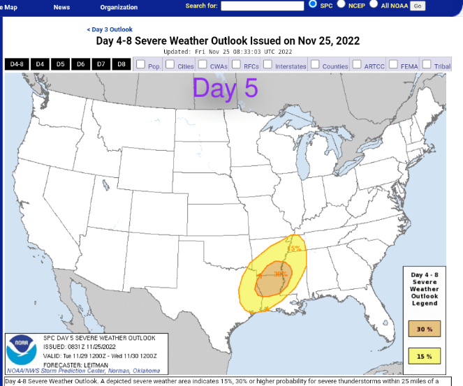
ZCZC SPCSWOD48 ALL ACUS48 KWNS 250831 SPC AC 250831 Day 4-8 Convective Outlook NWS Storm Prediction Center Norman OK 0231 AM CST Fri Nov 25 2022 Valid 281200Z - 031200Z ...DISCUSSION... Medium-range guidance continues to show a potent large-scale trough digging south across the western U.S. on Day 4/Mon, and ejecting eastward across the Plains toward the MS Valley on Day 5/Tue. As this occurs, strong southerly low-level flow will develop across eastern parts of southern Plains to the Lower MS Valley in response to strengthening cyclogenesis over the central/southern Plains. This will transport unseasonably rich Gulf moisture northward across eastern OK/TX into the Lower MS Valley beneath intense vertical shear. Details continue to shift with regards to the north and east extent of quality boundary-layer moisture return, and in how far east a surface cold front will surge by Day 6/Wed morning. However, agreement between deterministic, ensemble and machine-learning guidance supports greater than average confidence that a corridor of severe potential will exist from eastern TX into the Lower MS Valley on Day 5/Tue. Furthermore, a corridor of enhanced severe potential appears likely within the broader risk area across the ArkLaMiss vicinity. While confidence is high that severe potential will exist on Day 5/Tue, the area delineated may continue to shift some in the coming days, depending on trends in system amplitude and within forecast guidance. Forecast guidance varies quite a bit moving into Day 6/Wed regarding the extent of the warm sector across the central Gulf coast vicinity. Some severe potential may continue into parts of MS/AL/GA/FL, but confidence remains low regarding intensity and coverage, precluding unconditional severe probabilities at this time. By Day 7/Thu, strong surface high pressure across the eastern U.S. will result in a dearth of boundary-layer moisture, and severe potential will be low. Medium range guidance then depicts another large-scale upper trough over the western U.S. shifting east toward the Rockies/Plains, supporting another surge of Gulf return flow across the south-central U.S. Severe thunderstorm potential is uncertain on Day 8/Fri, but could increase late in the period into next weekend. ..Leitman.. 11/25/2022 -
The rare November 30% region has popped up again for day 5. Feels like given the rather concerning wording from NWS that a potentially mdt-high end weather event seems possible for Monday (edit: TUESDAY). At this points seems like it's worthy of it's own thread. Will we see another late fall svr wx event? It bears keeping a very close eye on the incoming d3 prediction, especially if you're in the 30% ENH risk this far out.