CryHavoc
-
Posts
255 -
Joined
-
Last visited
Content Type
Profiles
Blogs
Forums
American Weather
Media Demo
Store
Gallery
Everything posted by CryHavoc
-
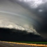
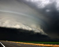
Large multi-vortex tornado crossing I65, per
-
I know it's not recommended to talk about ratings on this site, but I would be absolutely stunned if that was less than an absolutely maxed out EF4, or worse. I didn't have radarscope in 2011 for my phone, but I've been seeing colors/signatures I've never seen on that app before. Feels like a historic tornado on the ground at the moment.
-
Oh my god. It's so violent. Huge wedge. Can't see the motion, but don't need to.
-
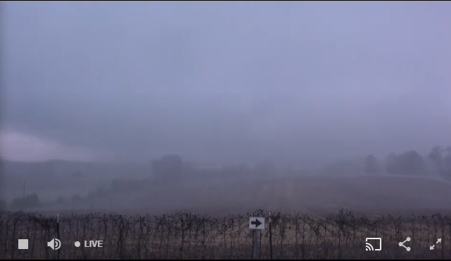
It looks like Humphress has the tornado on his stream.
-
Chasers were talking about it crossing directly in front of them. Sad to say but they could have been caught out. The South is brutal to chase in -- look how few options they had. It's basically one major road from Eutaw to Greensboro, and it's so heavily forested in that region.
-
I just don't understand the mindset behind calling bust every 3 minutes. I completely recognize that no one wants a violent day, but a couple people were calling bust around 11:30 on 4/27. It's really tiring to read in every single outbreak someone calling bust just to, what? Pretend like they're better at forecasting than the pros? I don't get it.
-
His stream has been stable for a solid 40 minutes now, really impressive.
-
The velocity on that storm is really, really impressive.
-
John Humphrees is in some extreme winds on his stream on severestudios.com Trees bowing and heavy precip. Debris on the road.
-
A COUPLE INTENSE TORNADOES LIKELY That is extremely strong wording. Wow.
-
Man, that reminds me of Twister when the ominous music starts playing as the chasers realize something is very wrong.
-
What a monster.
-
Wow, that webcam on James Spann's feed is directly in the path.
-
Things are certainly taking a more serious turn. This day looks like a go.
-
From WNW to ENE. There's a bit of turning going on.
-
This is exactly what I'm going with. Maybe with a cursory nod toward something a bit bigger. Tomorrow just has that "Gonna be a bad day" taste in my mouth, ominous and stark. I know gut feelings are worth less than the HRRR on a bad day, but still.
-
"Waterspouts possible." Am I doing this right?
-
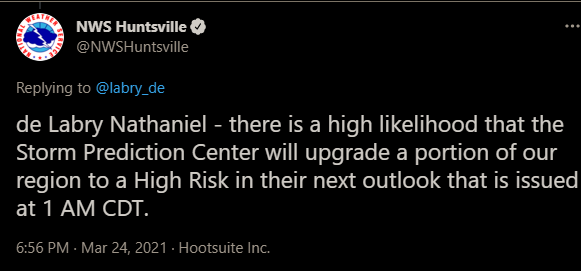
NWS in Huntsville just all but guaranteed a high risk upgrade incoming.
-
Probably the most incredible thing, at least from my personal standpoint, about 4/27 was how many well-defined, sustained hooks we saw flaring up in the atmosphere in a relatively small amount of space. At one point it seemed like every single cell that even started to grow was immediately isolated and spinning, even if they had a very potent neighboring cell just 5-10 miles away from them. I'm not a Met, so perhaps this wasn't as surprising to the pros in this forum/elsewhere, but I had never seen storms that close together be able to fuel themselves so powerfully, and wasn't even aware that parameters could exist that would permit so many mature supercells to develop so close together. It was hard to believe that we had so many tornadoes on the ground in such a confined area compared to the 74 super outbreak -- although you could argue there may have been unreported tornadoes from that day, it was harrowing to see an entire section of a state covered in red tornado warnings with multiple tornado emergencies being sent out at the same time.
-
Most people do not even know what the SPC is. And most of those that do are not poring over charts to discern the differences between ENH/MDT/HIGH. We're in the niche of niches here. So yeah, while to the average layperson a "Moderate" risk might not sound threatening, I doubt many of them are looking at advanced modeling to determine exactly what that means. They turn on the weather, see the Mets on TV with their coats off and their serious face on, uttering words like "Potentially historic" or "a long day ahead for much of the viewing area, keep your weather radios on" and assume that things could get really nasty. Jojo is not the type to be overly bullish without reason IMO. I think they're just pointing out that the ceiling here, if the SPC sees things resolving at the right time and place, is a Day 2 high. Heck, we might not even have a Day 2 MDT tomorrow (although I think that's much more likely).
-
MDT risks are quite rare, esp for D2, and mean anything but average. MDT risks are enough for local weathermen to start talking about a big weather day, which usually alerts most people to the fact that the day could be really rough.
-
Indeed. There are so many variables in forecasting something like this, and forecasters like yourself always have to be wary that the public is constantly finding reasons to doubt forecasts if they don't line up exactly with expectations. It's a serious catch 22, and why I generally chafe when I hear "bust" talk thrown around on days like this -- I remember reading from no fewer than 2 posters that 4/27/11 was already busting around noon, and that sort of dialogue is problematic in general. I think they were pretty close to bang-on with this. We're fortunate that we (likely) didn't see violent tornadoes today (and hopefully won't through the night hours). But it might anger people who believe that a high risk day always indicates a massive outbreak with dozens of fatalities.
-
It doesn't require any EF4/EF5s to verify high risk, if the NWS wording for high risk is to be followed. High risk specifically indicates a strong (60%?) chance for EF2+ tornadoes. What do you use as a definition for high risk? Has that changed in recent years? I was just looking over that criteria last night, but it was from 2008.
-
Ah, I see those now. Just been a long day of refreshing twitter, this page, discord, and watching streams. Haha. I feel like we only need one big cell to wind up and drop a monster and it takes the event from "very solid outbreak" to "a historic day".
-
Calling this as "falling short" is pretty ridiculous, frankly. We haven't even had damage surveys out. I understand the desire to see an EF4/EF5 maxi wedge OTG with a clear video/chase sequence on a high risk day, but that does not need to happen to satisfy the justification for high risk criteria, particularly when we're still relatively early in the event.