

Harry
-
Posts
5,187 -
Joined
-
Last visited
Content Type
Profiles
Blogs
Forums
American Weather
Media Demo
Store
Gallery
Posts posted by Harry
-
-
After 12z runs tomorrow I'll start paying closer attention to the short range stuff. Thus inside of 36 hrs.
-
23 minutes ago, michsnowfreak said:
It would have been wonderful to experience 1880-81, but honestly from all aspects, not just total snowfall, 2013-14 was the dream Winter for this area. Absolutely perfect.
No argument from me about 13-14. That is was. Could be a very long time before this area sees over 100 inches let alone just a shade above 117. That record should hold for a while I suspect.
-
 1
1
-
-
2 minutes ago, Lightning said:
Looking at the dynamics with this storm I believe heavier rates will be there! Plus heavy wet snows seems to be the norm this winter here.

Outside of Christmas I won't argue that. Strange winter for sure.
-
2 minutes ago, RCNYILWX said:
I try to avoid looking at the HRRR at this lead time because it's a hot start model and frequently all over the map for winter systems. I really don't think it was meant to be used for winter forecasting outside 18-24 hours. It's more useful inside 12-18 hours.
While it doesn't mean a particular solution in its extended runs can't have the right idea, it's much more often wrong than right this far out and therefore hard to put any stock in it. It was very bad for the ice storm (too warm) and also the event before that (too cold over northern IL). It may have performed decently for the pre Christmas storm at this lead time, but that's the only one that sticks out to me.
I keep forgetting that about the Christmas event and in my case Les which it went overboard with. The clue in that ( Les speaking ) was the strong winds and bitter cold temps which resulted in pixie dust flakes and banding that got ripped apart initially. Fooled a few because of the November Les event around here. Temps were not bitter and wind wasn't as strong but enough to bring the better banding further inland vs normal.
-
3 minutes ago, Lightning said:
Baby steps.

We may end up with the desired track for sure but I still worry a little about thermal profiles. Gonna need those heavier rates to get some decent totals.
-
2
-
-
1 minute ago, Stebo said:
It started west but ended flatter.
Any little thing helps us at this point with those kinds of trends atleast.
-
Great thing about the site I use is it allows me to put county lines and interstates on top. Great for spotting smaller changes that may not as seem as obvious without that.
-
2
-
-
9 minutes ago, Stebo said:
Both look like they may come in NW
Meanwhile the HRRR is definitely in the south camp.
It's actually a bit se. 18z took the slp over top my head while 00z keeps it south. 0 line stays near/just south of here vs 18z which got it up to Grand Rapids and kept it north of here.
-
2 minutes ago, Stebo said:
We are as early as 36 hours out and have significant model discrepancies on location for the snow band.
MJO phase 7 usually delivers the goods to us in S.MI. Phase 6 further west/nw vs phase 8 se.
-
2
-
 1
1
-
-
2 minutes ago, RCNYILWX said:
Very good agreement between the 18z EPS and GEFS actually with that shift south of the EPS. But that also means there's still a decent # of members north of the operational, similar to the 18z GFS/GEFS.
When the 18z Euro did shift south, it was a good reminder to me to not necessarily put too much stock even into a model I tend to trust more, particularly in this type of forecast that is sensitive to relatively small changes in the setup and the mass fields.
@OHweather, great post btw. Would you put more trust in the ensemble means at this point? Wondering if that may be the way to go since they've been generally more stable than the operational runs.
Sent from my SM-G998U using Tapatalk
In the past I have found that way is a bit more reliable especially where qpf amounts is concerned.
-
21 hours ago, michsnowfreak said:
Unfortunately it looks like Minneapolis did not keep records at the time, however at Detroit it is the 2nd snowiest winter on record with 93.6". It held the number one spot until the wonderfully epic Winter of 2013-14 dethroned it with 94.9". Also, the book "The Long Winter" by Laura Ingalls Wilder is a fascinating read, I don't give a damn if it is a children's book lol
That I think was a region wide epic winter. It's also Lansings record with nearly 95' inches. Near certain it went over a 100 here.
We need one of those kinds of winters stat! Talk about hyper active.
-
13 minutes ago, Stebo said:
My guess they shift SE with the op.
They are and by a bit at that.
-
1
-
-
3 minutes ago, RCNYILWX said:
I can confidently say that part of the problem with the ice storm forecast out there was the new ptype methodology we were forced into this winter. We had imo a much better system in place for several years up until last year.
Sent from my SM-G998U using Tapatalk
Wow. Sorry to hear that. Hopefully they revisit it.
-
2
-
-
1 minute ago, Stebo said:
See out this way the GFS was the best for the ice storm, and has been the better model as of late, it locked in 4 days in advance and didnt move.
Gotta agree with this. Recall the crazy amounts of snow the euro held into up around msp as well?
Great thing about these forums and recent events is it doesn't take long to see how the models etc performed which I am about to do as I know I have forgotten things even recent.
One thing I do know is the offices here etc had the heaviest ice too far north.
-
2
-
-
5 hours ago, Brian D said:
Would be interesting to see data from the decades prior to the 70's. Being a colder/snowier decade as the start point doesn't reflect the fullness of the record. At least go back to 30's-40's when airport measurements started to keep things a little more homogeneous.
Most around here would have slit thier throats during the 30s, 40s, and 50s around these parts especially the 30s and 40s which only saw this area break the 40inch mark once I do believe which is incredible considering the last 23 years or so which hasn't seen a winter below 40 once. Only below 50 twice. Have to imagine away from the lake belts were worse off?
-
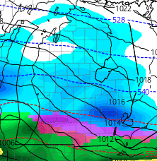
8 minutes ago, sbnwx85 said:
18z GFS Kuchera

Snow depth change:
Wonder what they are using? Was near certain the one I use is set at 10-1? Maybe not?
-
Think I need to change my shorts after viewing the 18z gfs. Certain it's overdone but still with this site set at 10-1 ratios near 15 is always nice to see.
3 minutes ago, michsnowfreak said:Oh yes it's definitely too early to give a grade. With the colder look heading in to March you have to like the chances that something is going to pop.
Speaking of cold, regardless of which model wins this circus of solution For Friday, there really does not seem to be much cold air with it so I'm not feeling this one or thinking it's gonna be a January 25th redux.
Yeah Friday is looking like one of those heavy wet snows around here which while they are scenic could be a problem here especially with the wind and saturated soils that's not good for the trees.
-
2 minutes ago, michsnowfreak said:
Wow. That's definitely higher than my grade would be. Although, the photogenic nature of the January 22nd and January 25th snowstorms, the February 22nd ice storm, & a postcard White Christmas, it's definitely not in the dire straits some others on here appear to be.
My biggest issue was the relentless cloudy, drizzle, upper 30s/low 40s days and even nightd. Had they been more like yesterday and especially today my grade would be a bit higher. What pushes my grade higher then most was the White Christmas and the Nov Les event which dropped 21+ here. The ice I never lost power ( unlike many others around here ) so I got to enjoy the beauty of it which scores a few brownie points. Still a bit to consider so no grade yet.
-
2
-
-
24 minutes ago, Lightning said:
The -NAO is good. Just wish we had a bit of a -AO or really a neutral one.
Historically our best storms have come when that is near neutral.
-
2
-
-
Best thing going for those of us in southern MI is the mjo emerging in phase 7. Usually a ideal spot to be for those wanting a more southerly track across IN/OH.
-
1 hour ago, Hoosier said:
Pics or it didn't happen.

Stay safe.
If I can I will. This phone acts retarded sometimes and I am not sure if I exceeded my limits here as I think there used to be one?
-
12 minutes ago, Stevo6899 said:
Yea its gonna break record highs down here in estero this week. It's humid too but tbh it's no worse than summer humid heat in michigan. I'd imagine come summer, I'll notice a bit of a difference lol. Def beats frigid cold.
I'll pass on both..
-
1
-
-
21 minutes ago, RogueWaves said:
22/0z RGEM pounding Metro Detroit with snow tomorrow noon

Then proceeds to destroy with ZR
I am gonna have a backyard full of downed trees and power lines . Ugh
-
 2
2
-
-
1 minute ago, RogueWaves said:
Gotta expect some bumps with the overnight issuance. I don't have a good feel for how robust the grid is since I'm new there and the wx has been mostly a snooze-fest in every season. Marshall was pretty robust with their own power generation system. It took a lot of trees coming down to be in the dark (May 2011 near twister, 11-13-17 severe). I have no benchmark. All I know is if my wife and pets are sitting in the dark unheated apartment, that'd be a bad thing. At least with the place in Marshall we could fire up a couple burners on the gas stove for a little bit of heat. Did that more than once. No such option now.
Yeah I keep forgetting about the ole stove. Thankfully this house does have a fireplace as well.
-
1
-
Remembering 1/5/2014, "The Polar Vortex"
in Lakes/Ohio Valley
Posted
Loved the 18 I got. Hated the next day because I had shoveld the night before as the snow was letting up only to find the bitter cold winds undid it all. Only time since I have moved here they told people here they were not allowed to drive on the streets.