

Harry
-
Posts
5,187 -
Joined
-
Last visited
Content Type
Profiles
Blogs
Forums
American Weather
Media Demo
Store
Gallery
Posts posted by Harry
-
-
29 minutes ago, RogueWaves said:
Looking like one for the ages along 94. Been a while since GRR spent so much ink mentioning anything besides "131 and west".
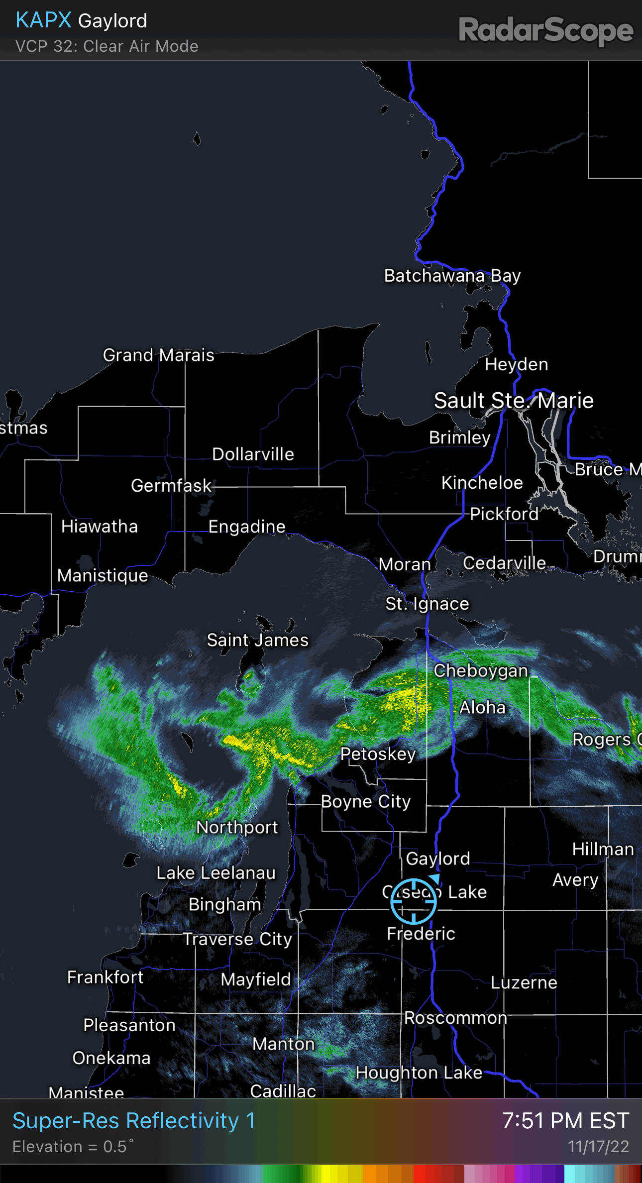
After a brief intermission, we will see a very rapid onset of a new
round of snow across the northwest forecast area shortly after sunrise
Saturday. This event will feature substantial synoptic lift thanks
to a deepening and sharpening trough upstream and an associated
cold front over Wisconsin that is already producing snow. Meanwhile,
farther east over Lake Michigan, the boundary layer will quickly
deepen with convective instability exceeding a depth of 10000 ft.
This deep lake instability plume is expected to rapidly penetrate
far inland, bringing with it an extremely fast onset of heavy snow
and poor visibility that should extend northwest of a Muskegon to
Clare line by the 9 AM time frame.

This area of lake enhanced snow will expand very quickly so that by
1 PM its leading edge will extend approximately from the southwest
tip of Lower Michigan to Lansing. Snowfall will be quite intense
at this point across far southwest Lower MI. In fact, latest WPC
guidance gives Grand Rapids 3-4 inches of snow between 1 PM and 7
PM Saturday. This is the kind of daytime snowfall rate one would
expect in mid January instead of mid November.

The contributing lake-induced fgen region mentioned previously now looks
to be a bit more progressive than earlier thought thanks to the cold
font moving in with more authority. Even so, it appears we should
see a dominant and more purely lake effect band developing in its wake
and persisting through much of Saturday night with heavy snowfall.
Unfortunately, this band looks to be closely aligned with I-94, as
is often the case in these scenarios.

In contrast, areas farther north closer to US-10 we should see a
gradual cessation of lake effect snow Saturday night around the
same time things are staying interesting around I-94 as described
above.

In addition to accumulating snow through Saturday night, we are
concerned about strong winds increasing the hazards of exposure to
cold, poor visibility, and possibly drifting. Saturday`s daytime
wind chills may actually be lowest over the southeast forecast
area as this is where winds will be the strongest. Drifting of
snow remains a concern, especially since we`ve already seen a hint
of this here at the office.
And they've added winds to 40 mph in the headline wording too. I know you're not the biggest wind geek like me, but you have to admit it's pretty wild for the first real event of the season. And ofc, it finally happens 1 yr after I've moved on.
Yep. I'll pass on the winds. That could also screw with the expected i94 band I think? Well see anyways. I am in no way a expert on this lake stuff.
-
Hoping that system makes a comeback late next week. Would love to challenge that Nov 2000 snowfall record of 28.
-
Did my Jeb walk last night ( two miles ) and thought about doing another tonight but ughh the wind chill... Perhaps tomorrow night when it gets crazy? Basically considering leaving the vehicle home and walking to and from work which is just over two miles each way?
-
 1
1
-
-
Latest AFD from GRR suggests tomorrow afternoon/night may be more intense with a dominate i94 band setting up.. 2 feet perhaps when all is said and done here? Crazy if it materializes.
City here just issued a snow emergency for Tomorrow into Sunday. Only other time had one of these was with GHD II.
-
3
-
-
1 minute ago, Chicago Storm said:
0200 PM SNOW 2 SW BLASDELL 42.77N 78.87W
11/18/2022 M48.0 INCH ERIE NY TRAINED SPOTTER
STORM TOTAL SO FAR. ATHOL SPRINGS. 6 INCHES
OF SNOW FELL IN THE LAST HOUR (1 PM TO 2
PM).
.They are definitely going over the 6 foot mark! Insane!
-
Just saw the Detroit radar! What's going on over there? Bands still look decent over there.
-
1 hour ago, WestMichigan said:
Farther inland seems to be the winner with this one. GRR did quite well while here in Zeeland at work there was maybe 2" this morning. Don't know if the winds were too strong and blowing everything inland but I have seen some crazy totals for LES in places you wouldn't normally expect it.
Just talked to the boss who's place is just south of the zoo and he said only about 2 inches there so far. Snowing good here now..
-
9 minutes ago, RogueWaves said:
Yeah, not that that would hurt the cause, but it'd still be the dispersed version, just a bit heavier. To mimic KBUF, you'd have to re-draw the shape of SWMI's coast line so it funneled to a point just west of Kzoo. That'd be about perfect I think.
")
Yep. That would do it. Crazy totals for around here anyways. Totals from 4 just south of town on up to near a foot in Pennfield/north side on back to Kalamazoo from what I am hearing via channel 3.. About 10 here by Emmett St and or a couple of blocks from Pennfield.. Work is about a little over two miles south so it will be interesting to see what a difference that makes. I'll be there in a hour..
-
1
-
-
Just now, WestMichigan said:
We have had more graupel/pellets than actual flakes at times. Still slowly adding up but certainly not a good way to run a winter storm warning level of snow.
Thus the problem with les especially with these types of bands and cellular stuff. Huge cut offs. Right now between either side ( to i94 on the southern end.. And to about i96 on northern end) of and including Allegan and Berry looking to be ground zero. So far anyways. See what happens once the wnw flow settles in and we get a better moisture supply again along with colder air.
-
19 minutes ago, Chicago Storm said:
6.0" in the last 2 hours at BUF.
KBUF 180254Z 00000KT 1/4SM +SN FZFG VV003 M01/M01 A2996 RMK AO2 TSB04E23 SLP153 TS DSIPTD SNINCR 3/6 P0000 60002 T10111011 58008 RVRNO $
Too bad we cannot add another 100 miles east to west across our lake.

-
16 minutes ago, RogueWaves said:
So far it looks like the surface winds are actually cooperating in more or less a due westerly flow. Marshall may finally do ok.
Yeah if we can keep this going all night I think we could see warning criteria amounts almost to Jackson. Rare air for sure. See what happens once the flow settles into the wnw direction in a little bit. I think the cellular look to some of it could have to do with the low level flow wsw to sw while above it has become westerly. Plus the patches of drier air. a bit better moisture should be heading over the lake shortly. So between all of that coming together in a little while it should fan out a bit more and intensify. We'll see anyways.
Ofcourse later tomorrow/tomorrow night the flow should start backing again towards the wsw and even sw ahead of the next impulse on Saturday and then back to wnw/me later Saturday into Saturday night which should light it up again.
-
2
-
-
1 hour ago, josh_4184 said:
Wonder if I will get clipped from the meso should be some intense snow rates.

That is wild looking!
-
1 minute ago, frostfern said:
Not too surprised. I didn’t hear or see anything but that band was intense for 45 minutes before it shifted more to the south. Hopefully the Saturday event will be more solid coverage. The monster sized flakes today were cool, but it hasn’t been persistent and its a little sloppy and heavy compared to a normal LES event. Its not super dense, but its not that really light 20:1 ratio we sometimes get either. More like 12:1. The next one is supposed to be colder.
Living life on the edge here but thankfully on the good side with the persistent band that's been rolling along between i94 up towards the county line. If that can hang around most of the night should do very well here. Hopefully it spreads out some for you guys..
-
Latest aviation from GRR said there was some lightening with the stuff towards i96 to the north of here.
-
Thanks for starting this thread.
They ( w.NY )are about to get a nice boost from lake MI as these bands look to make a run across the whole state.
Been snowing at a very decent pace the past hour or so with a nice band extending from here back towards the lake. Roads etc all snow covered now.
-
2
-
-
57 minutes ago, WestMichigan said:
NWS Point and click has me with 15" by Sunday. Not liking how things are starting off today but maybe there will be some improvement later on.
Wasn't really supposed to ramp up till later today and tonight. Radar trends looking better. Might be one of the best set ups we see.
-
6 hours ago, RogueWaves said:
Oh. Yes that week long LES event in Dec '01 was just stuck on a WSW trajectory making Petoskey the winner in The Mitt. Not even sure what totals were elsewhere. I was really disappointed in S. Bend as that wind direction is a no-go and the potential historic outbreak had been spoken of for days prior.
Finally someone answers that question I had been wondering with that event. Wsw flow. Wow! That left 18-24+ around here which is beyond incredible for this far inland.
-
1
-
-
Just gotta keep the flow from bending too far out of the south .. That could be the biggest issue here.
-
8 minutes ago, cyclone77 said:
Bills have home game Sun. Could be a fun
I was looking at that. Crazy! 3-4 feet? Makes our foot+ possible totals around here look like peanuts but still impressive for these parts.
-
4
-
-
1 hour ago, WestMichigan said:
Yes, I am still Just north of the Ottawa/Allegan county line. GRR is saying 8-12 which would be a rather impressive LES event for this part of the state for sure. Hard to keep the winds blowing the right direction that long for us to see those totals. Looking forward to seeing how this unfolds.
Looking upstream etc I honestly think a foot+ is looking good for your backyard.
Surprised there is no thread for this?
-
2
-
-
5 hours ago, WestMichigan said:
Turn it sideways and we would be in business.
You still in the Grand Rapids area? For these parts this is looking to be one of the most impressive les events I have seen. Rare day when GRR has warnings flying all the way to here and or including 3rd row of counties. Ofcourse some of the models have gone into the unknown with qpf amounts ( UK/Canadian inch + ) I have never seen this far inland that I can recall? Even the normal models showing between a half inch to over .75! You are in a solid spot if you are still by Grand Rapids?
-
3 hours ago, sbnwx85 said:
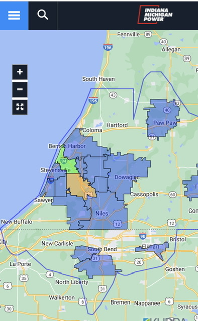
The lake effect band has largely stayed to my north all morning. Just a coating here. The heavy, wet nature of the snow is causing power outages already in parts of Michigan. 5,400 Indiana Michigan Power customers are out.
Ended up with around two inches from this last system. Ofcourse my attention is now on this LES starting tomorrow. Some of the models spitting out crazy amounts for this far inland that I have never seen before. Uk and Canadian spitting over a inch qpf. BS for sure but still have never seen that ever that I can recall?
Anyways GRR just upgraded to a warning out to/including the third row of counties between i94 to i96.
-
2
-
-
Right now I'll take the 70+ stuff we had today over the crap we are looking at this weekend. Yes as I get older I am favoring warmer. Ofcourse cold by itself has never done anything for me anyways..
-
2
-
 1
1
-
-
Any time I think of 3rd year Nina's I think of 2000-2001. Thing with that was it started off great but crapped out after the new year. December saw many snowfall records fall that still hold to this day. Even November around here set the record for snowiest Nov that still holds to this day. My thoughts had been and remain that if the winter stuff got going early in the month it would go till Jan and then perhaps fade out much like 00-01 but if it waited till later in the month it would hold till March.. We'll see. Wanna see that shitty nnw/n flow bs go away first along with a favorable storm track.
-
2
-
Historic Lake Effect Event?! 11/17-11/21
in Upstate New York/Pennsylvania
Posted
Woah.. That's a highway?