

Harry
-
Posts
5,187 -
Joined
-
Last visited
Content Type
Profiles
Blogs
Forums
American Weather
Media Demo
Store
Gallery
Posts posted by Harry
-
-
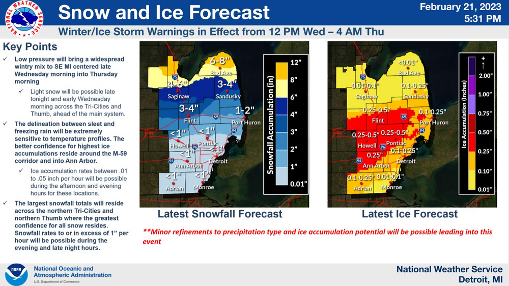
The goofy maps I am seeing is assuming it's all snow here nearing 18 inches with a sharp cut off at the county border to the south. Sigh.. I know that's bs. Gonna ask them about some ice maps for this kind of stuff.
-
00z GFS actually looked more snowy/sleety. Hope someone can confirm this with those ice maps?
-
2 minutes ago, Powerball said:
This would be one of the worst ice storms ever for Detroit if the 00z models are right. Definitely a bit more concerning now given that we're less than 24 hours from the onset of precip.
That said, several things could still happen to make for a better outcome.
1. More snow/sleet at the onset.
2. Less total QPF (00z models were atleast drier than prior runs).
3. Surface temps are being underestimated by models.
I'll take anything at this point..
-
 1
1
-
-
2 minutes ago, RogueWaves said:
So technically, DTX's icing map actually already has the far NW corner of Wayne (aka mby) in the same shading as those to my SW in the ISW. Not liking this at all.
And like GRR I think those icing maps etc are too low..

-
20 minutes ago, Harry Perry said:
I definitely think IWX and DTX will be adding and expanding overnight looking at the majority of the 00z data.
They need to. GRR needs to up ice amounts as well around here unfortunately. And remove the mention of rain.
-
 2
2
-
-
30 minutes ago, Harry Perry said:
Damn, that’s no good. That storm (believe it was 2018), was strange around here. You could go out Pennfield/Bellevue and it was awful, but the minute you turned onto Raymond Rd and headed south to Michigan Ave, very little in the way of ice. Two different worlds minutes apart.
Yep so you can guess where I am. Other then this one ocean effect snowstorm I have never seen such drastic cut offs with ice, snow etc till I moved here. Look at that November Les event. 21 this part of town ( north ) vs a few inches out by/just south of Beckley. Have seen the reverse as well when I first moved here. Crazy stuff.
-
2
-
-
Funny part is one of the reasons I bought this house was because of all the trees along the edges/fence but yeah I am regretting that now.
-
2
-
-
17 minutes ago, RogueWaves said:
I edited my post to say the last bad one I remember for Calhoun was Dec of 2006. There were one or two more in early '07 and a minor one during the mid-Feb 2011 storm. Dec '06 could've cost me my life as I drove my car straight through a massive tree downed across the entire road in the dark.
The best thing about that winter was that lake length les band that got pulled in our way via that meso low.
Ofcourse that ice storm in April a few years back ( 17 or 18? ) sucked as it took out half a tree that crashed through my deck railing and deck out back but thankfully soft landed on the house. Terrible sound when it crash landed and thought it had taken out my bathroom window upstairs which thankfully didn't.
-
3
-
-
2 minutes ago, michsnowfreak said:
DTW was at 9.0" thru Mar 19, 1983. Then got 11" in spring. That said, I can't imagine going thru that Winter here. My mom was pregnant with me so I guess I kinda did lol.
You would have lost it in 97-98 where I was living. I wasn't happy for sure but we had some crazy noreasters that winter that made it somewhat interesting living at the beach.
-
1
-
-
36 minutes ago, SolidIcewx said:
Let’s get the ice skates out
How I'll be getting to work..

-
3
-
-
5 minutes ago, Harry Perry said: Not liking the looks of that.
We are screwed.
-
3
-
-
27 minutes ago, michsnowfreak said:
Yeah Dec 2000 was awesome. The rest of the winter was zzzz city. Not sure about the overall national pattern tho.
If the warmer stuff had actually been a little warmer I wouldn't have minded this winter. The endless cloudy, drizzle and low 40s stink. What's keeping my grade up is the White Christmas and 21+ lake effect event in November.
00-01 wasn't too bad back east where I was living for that climo anyways.
-
2
-
-
2 hours ago, Geoboy645 said:
1982-83, 2000-01, and 1964-65 have all been pretty similar analogs to this winter with the deep snowpack to the north and an active December followed by nothing south. 2001 and 1965 also had pretty snowy Marches as well, followed by major flooding on the Upper Mississippi. It will be interesting to see if the parallels continue into spring or not. And both 01 and obviously 65 were pretty active Aprils for severe in our region as well.
Nov and especially December 2000 rocked here. Over 50 inches alone in December which to this day holds the top spot for snowiest month ever. That November had held the top spot for snowiest November till this past November. Rest of the winter did kinda suck though.
Thankfully I was living in the DC area in 82-83 which got slammed by what was referred to as the megalopolis blizzard in Feb with 18+.
-
19 minutes ago, WestMichigan said:
That has been the theme for most storms this winter. QPF gets cuts back over time.
Tried telling people this yesterday. Been that way for years. I doubt the trends are done as well. Hoping for a miracle here. Not sure I'll get it.
-
3 hours ago, ILSNOW said:
I know that it prolly means nothing but lets welcome the 12z NAM to the cold side

The one constant lives on. Figured the short range stuff would do this.. Better get some extra logs for the fireplace..
-
2
-
 1
1
-
1
-
-
24 minutes ago, Natester said:
0z UKMET another tick north. Looking unlikely that we will get ice here. That's perfectly fine with me since I hate ice.
Any little tick north helps here. Just not enough yet but getting close.
Ofcourse I don't follow this model as often so not sure how reliable it is in these situations?
-
4 minutes ago, StormChaser4Life said:
Right! So frustrating! Would love the opposite!
Really has been a few crappy years huh? Ofcourse I didn't notice as I used to as I have been too busy doing other stuff. Ofcourse the mid/late 2000s and 2010s kinda spoiled us with them 80, 90, 100+ winters here. This area went 15 or so years without a winter below 60 inches.
Fyi. Back in the 1930-60 period the normal here was around 40 with only two going above the 60 mark and a slew of 18-30. For the time being it's now closer to 70 thanks to the 2000s and 2010s. 97-98 was the last time this area failed to make 40 or even 30..
-
3 minutes ago, mnchaserguy said:
Short and medium range models are showing the same thing the long range have been showing for a week. Not sure what the problem is here.
.For around here it's night and day between the short range vs the others. Bad ice storm vs plain rain. I am hoping for the rain but I know better then to trust those models showing the rain. Alot of tall trees and power lines behind my house so yeah I'll pass on the ice. Ofcourse ma nature is gonna what it likes.
Ofcourse I have more personal reason for not wanting the ice either which has to do with Thursday night plans.

-
1
-
-
1 hour ago, RCNYILWX said:
Year without a winter there - unreal. My parents and brother live in NYC still and it's been extended November. Certainly been mild here but we've had some winter, just less of it than usual.
Sent from my SM-G998U using Tapatalk
I remember 97-98 being the only winter I didn't see a flake of snow. Ofcourse part I spent in VA beach and the other in Delaware at the coast..
-
Since when did this board start bowing down to the short range models beyond 36 hours?
-
5
-
-
10 minutes ago, Harry Perry said:
00z NAM sticking to its guns.
Usually does till it gets inside of 36 hrs.
-
4 minutes ago, Cary67 said:
Hard pass on that.
Same. Need to get a south trend going tonight.


Gonna pull out the ole magnet..
-
21 minutes ago, RogueWaves said:
Just going off my grid-cast when I last checked.
Yeah I don't get these offices that do that? Ofcourse both offices are notorious for following whatever model has the warmest outcome. But yeah GRR has rain or freezing rain for here. Yes I would gladly take rain over freezing rain. Time to cross fingers for a better outcome with the 00z models be it colder or warmer.
-
1
-
-
32 minutes ago, RogueWaves said:
Not sure which is the bigger joke? One day below freezing during 2 wks mid-winter, or being in a Watch for 100% chance of RN
Rain? Where are you at now? Anywhere along/north of i94 is gonna be some form of wintry precip. Unless you are following the short range models that mostly rain ship I think has sailed off. Jmho

February 21-23 Major Winter Storm
in Lakes/Ohio Valley
Posted
The 850 0 line does hang around longer and briefly drops south of here during the heaviest stuff. Had been staying north of here. So I figured it's possibly more snowy or sleety vs earlier runs.