

Harry
-
Posts
5,187 -
Joined
-
Last visited
Content Type
Profiles
Blogs
Forums
American Weather
Media Demo
Store
Gallery
Posts posted by Harry
-
-
48 minutes ago, michsnowfreak said:
How much did you end up with? Just a dusting here. 37.1" on the season.
About 5. The band that came through here between 11pm and 2 am did the deed. I took a quick trip to the store around 1 and it was puking snow, Roads etc were covered and crappy.
-
 2
2
-
-
9 hours ago, michsnowfreak said:
It is here too. Always a bit low.
With the les yesterday and last night the seasonal total is now up to 81. So yeah that blue needs some expanding.
-
9 hours ago, RogueWaves said:
I get all that and precision suffers ofc. APX finds a way to make it happen. Perhaps they should share their secret with the two SMI offices. I like maps, lol. In your opinion, how far off are they on avg? 6" in a season, or even more in certain regions? And you hint that it is almost always a lower amount of snow. I'd be more concerned if totals were artificially inflated.
I have seen those maps be off 2+feet for seasonal snowfall. Ofcourse it's a bit trickier thanks to the lake out this way.
-
2
-
 1
1
-
-
4 hours ago, Cary67 said:
Those maps are always off and by a bit at that. Around here it is.
-
2
-
 1
1
-
-
Zone has 3-6 while p&c has 4-5.... Crazy to think that if the higher totals verify we will eclipse the 80 mark.
-
35 minutes ago, michsnowfreak said:
I doubt Harry averages low 50s yet. Avg high for Detroit today is 47, warming to 52 March 31st.
Yeah I am not sure wtf I was looking at but your right the normal high is 46.

-
43 minutes ago, rainsucks said:
NWS playing it conservative per usual, and the cold front that you’re referring to isn’t going to affect overall temps that much.
They could be over compensating for the lake effect expected later tonight into Saturday night. May take a few days to melt off depending on how much falls.
-
3 hours ago, rainsucks said:
I'm well aware of what our normals are, and all of next week looks to be above that, with Thursday in particular looking to be very mild for the region. Hell, you may not have a daytime high below 50 for the entirety of next week.
Nws has 45 Monday, 50 Tuesday, 49 wednesday, and 53 Thursday with a cold front incoming.
Normal high 50-51..
You were saying?
-
1 hour ago, Lightning said:
Kind of funny, as this year could challenge 13-14. That year was basically opposite with temperatures.

Plus 13-14 was more widespread with the snow. Gonna be hard to top that winter here at least with a bit over 117" for the winter here thus the record. Winter for the ages for most of the region.
-
1
-
-
1 hour ago, WestMichigan said:
It will be interesting to see if GRR can pick up enough to move up a spot into the 3rd snowiest winter.
I think the third spot is a lock.
And yeah I see they are pushing this les event a bit harder out this way.
-
Where are the west Michigan homies at? LES looks decent Friday night into Saturday night.
-
This goofy office will never learn with their 131 bs...
Regardless of them the LES setup looks decent around here. Can't wait for it to get fully into the Hrr range etc.
-
1 hour ago, rainsucks said:
This is not going to verify well imo, at least for our region. The 18th and 19th look to be the only actual cold days, with the rest of that timeframe being slightly above to potentially well above average, we'll see tho.
You do know what our normals are? Hoping you are right but I am not seeing it.
-
1 minute ago, Cary67 said:
^ Most years when do you mow the lawn for the first time?
Since I moved here May.
-
35 minutes ago, michsnowfreak said:
Meanwhile the last 3 April's at DTW
2022- 4.1"
2021- 3.6"
2020- 4.9"
The April 20/21, 2021 snowstorm dropped 3.6" at DTW but 4.4" here and with things blooming early, the scenes on Apr 21st were surreal.

April 2020 was 3.6 here. Every year prior had a few inches at least with April 2018 having 5 and that crazy ice storm. April 2017 had temps spring like ( mostly 60s and 70s even a couple 80+ ) but still managed 3.3. first week was a bit colder but after the snow it warmed quick and pretty much stayed that way.
-
15 minutes ago, michsnowfreak said:
With the rest of march and april to go, it's now a realistic goal to see if DTW can hit 40 inches. Definitely did not foresee that a month ago
Did you get anything from the big Nov les event? Biggest difference between the looks of this weekend and that is the lake is a bit colder.
-
3 minutes ago, Stebo said:
Not quite as cold but check the 18z gfs for this weekend almost to the day too.
I see it. Brr. LES set up looks great as well which is crazy in itself.
-
13 minutes ago, Stebo said:
I mean it hasn't been quite as extreme but pretty close, especially north of here.
Oh yeah. Similar pattern for sure.
-
13 minutes ago, Stebo said:
Duluth is going to make a run at their deepest snow depth on record. 48" is the record back in 1965, which this March has been following to a T so far.
March 65 here was about as snowy but the temps were even more brutal. Several days between the 19-21 the high was 20 and one it only hit 19 with lows in the single digits. 8 day stretch from the 19 the on it only went above freezing once. I'll pass on that.

-
The last couple of April's here hasn't been that bad. First two since moving here with less then a inch of snow. Actually had some 70s and 80s. Been a long shitty stretch of April's around here prior.
-
1
-
-
6 hours ago, rainsucks said:
11 years ago today was the start of what I personally consider to be the most anomalous temperature event in recorded history. 80s for days on end along with dews well into the 50s and even 60s (which provided us with very warm nighttime lows as well). Hard to fathom that happening now, especially with the current cold in place. At least next week looks decent
https://www.weather.gov/lot/march2012_heat
https://www.weather.gov/media/lot/events/March2012/March_Heatwave_2012_final.pdfWas 78 here on this day in 2012. Ended with 9 straight days in the 70s and 80s peaking at 84.
-
8 hours ago, WestMichigan said:
Another 2.5" and GRR is tied for their 3rd snowiest winter ever. Rather unbelievable stat given the roller coaster ride this winter has been.
What's the seasonal total at?
-
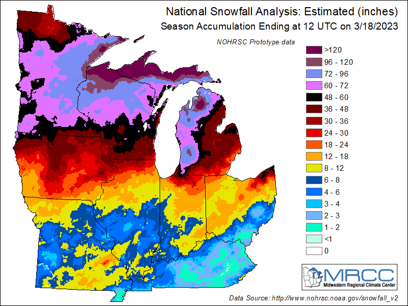
1 hour ago, mnchaserguy said:
Chanhassen NWS is at 90.7” for the season. Unfortunately the records go off of the airport measurements and they’ve recorded significantly less than the NWS considering they’re only about 20 miles apart. Looks like the airport is sitting at 80.7”, which is still good enough for 7th snowiest.
.Crazy gradient this year. Similar thing here with 75.8 here but about 30/40 miles to my nw/wnw over the 100 mark at the nws office etc. The drop off to the south of here is as impressive if not a bit more towards the sw.
-
1
-
-
11 hours ago, Harry said:
Not sure where to post this so I will do it here.
MJO in uncharted waters in phase 8 just brushing the edge of the chart. Thing is the models do drop it towards the COD in phase 1 or 2. One thing I have noticed ( since it got past 6 ) is the models have been correcting south with systems vs going the other way when MJO in those other phases especially 5-6. Not talking inside 24-36 hrs. I remember a few years back the models behaving like this. Something to watch for.
See the 00z euro etc.
For now at least we have some help with model trends via MJO. Till the next model upgrades or the MJO goes and hangs out in the COD.


March 2023 General Discussion
in Lakes/Ohio Valley
Posted
Increasing chance #2 gets taken this weekend.