

Harry
-
Posts
5,187 -
Joined
-
Last visited
Content Type
Profiles
Blogs
Forums
American Weather
Media Demo
Store
Gallery
Posts posted by Harry
-
-
Rivers around here starting to go over thier banks and more rain on the way?

-
6 minutes ago, TheClimateChanger said:
Urban heat island effect can explain some of the local warming. But how can Urban Heat Island effect explain that Minneapolis had a colder average high in March from 1873-1900 [1900 population: 202,000] than International Falls [a town of 5800 on the Canadian border known as the "icebox of the nation] or Duluth, Minnesota [a city of 86,000 on the shores of Lake Superior]? Or that the average March high in Chicago [1900 population: 1.7M], Detroit [1900 population: 286,000], and Cleveland [1900 population: 382,000] in the same period is less than Green Bay's [pop: 107,000] high in the most recent 13 years?
The lake I would think would keep it a bit warmer. I know Lake Michigan has saved our asses a few times from the coldest stuff the region has seen since I have lived here. Note record lows here vs say Ft. Wayne. Many of times it has been zero here vs -10s and even -20s west of the lake and down south of here across Indiana etc. A few times it helped to get lake effect ramped up as the cold air tries coming in via the SW/S clashing with the warmer air via the lake/nw/w flow.
This region has some incredible micro climates going because of these lakes which I have always find interesting to say the least. Can affect snowfall, temps, and even severe wx in spring/early summer.
-
2 minutes ago, weatherbo said:
You had a favorable setup. Lake MI hasn't warmed enough to change your snow climate. JFC.
.gif.93e3165c689d2d6303281f9eb8cb25eb.gif)
When I moved here I was told by many ( even a few on this forum ) I was to far inland to get into decent lake effect.
Keep in mind the average snowfall here between 1920-1950 was just over 40 vs today's near 70. The 80s saw a bump up and 90s back down a bit but from 2000 onward it has just exploded. The data for here goes back to 1895 and before 66-67 ( 96.8 )no winter had topped 80 and since 2000 the 90 mark alone has been topped 6-7times and the 100 twice.
What else would it be?
-
1 minute ago, TheClimateChanger said:
The 19th century March high temperatures for these big cities, mostly in the southern Great Lakes, compare to modern averages at places like International Falls, Duluth, and Green Bay! How can the urban heat island effect cause that?
Cleveland, Ohio
1872-1900: 40.9F
Milwaukee, Wisconsin
1874-1900: 37.1F
Detroit, Michigan
1874-1900: 39.7F
Chicago, Illinois
1873-1900: 40.9F
Minneapolis, Minnesota
1873-1900: 36.7F
Modern Equivalents
Green Bay, Wisconsin
2010-2022: 41.6F [warmer than Cleveland, Detroit and Chicago, and significantly warmer than Minneapolis and Milwaukee in the 19th century]
Duluth, Minnesota
2010-2022: 37.1F [same as Milwaukee, warmer than Minneapolis, only a couple/few degrees cooler than lower Lakes]
International Falls, Minnesota
2010-2022: 37.4F [warmer than 19th century Milwaukee and Minneapolis, a couple/few degrees cooler than lower Lakes]
Try looking at climo sites that have not seen such urban sprawl etc. Quite a few that go back to 1880s and even earlier in some cases.
-
1 hour ago, Danny8 said:
I've been curious about exactly this. The University of Michigan Ann Arbor records go back to 1881 on the NWS site. And University of Illinois at Champaign back to 1888. Would love to know more that haven't moved at all since the 1800s
Lansing goes back to the 1860s or used to? I looked at a few of them a decade or so ago. Even Coldwater had data back to 1880 or so.
-
Funny thing about this stuff is if you go to long standing smaller climo sites that have not seen the urban explosion you don't see nearly the same warming etc. Makes me wonder how much of it is due to population etc growth aka urban heat island effect?
Ofcourse I am nearly certain the lakes are warmer then they have been in a long time and I am near certain that has much to do with the increase in snowfall downwind in areas such as here. Atleast in the past 25 years or so.
-
On 3/27/2023 at 11:01 AM, beavis1729 said:

The 1981-82 winter (3rd on the above list) was a beast for MSP, highlighted by extreme cold and two large snowstorms in January.
Duluth is now at 133 consecutive days with 1"+ snow cover, with 32" still on the ground. They could hit 150 days when all is said and done, assuming a major thaw doesn't occur over the next two weeks. Record is 164 consecutive days, from 11/10/1995 to 4/21/1996.
Duluth's seasonal snowfall is 125.4" so far; the record is within sight (135.4" in 1995-96).

That Duluth record is surprising as that was a huge winter ( 95-96 ) along i95 from VA/coast on north. A number of seasonal records fell that winter with a few coastal locations ( DE/NJ/MD )blowing the doors off the record books.
-
4 hours ago, rainsucks said:
Please let this happen...
.png.e4218c51717c2db051270c70688a4fd8.png)
That's the key to warmer. A few models show it.
-
 1
1
-
-
Flipped to snow here a hour or so ago. Nice returns coming in via the lake but nothing sticking so far.
-
45 minutes ago, cyclone77 said:
Lol at the Euro trolling the QC again. There was a time not so long ago when if the Euro showed your area getting 10"+ of snow in less than 60hrs you were probably golden.
For this event I gotta say the models have remained more consistent then I have seen in a while. No nw or se trend etc. If only every system was modeled like this.
-
31 minutes ago, Baum said:
i think we all called this back in mid February.....sadly.
I believe Detroit's biggest snowstorm on record happened in the first week of April. Michsnowfreak knows alot more about that.
I am amazed it has not happened since?
-
1
-
-
9 minutes ago, TheClimateChanger said:
Well, every year is an early greenup compared to the start of the 19th century. If you transported someone from the 1800s, they would think even the "late" greenups you cite were exceptionally early. This is not my opinion either, but backed up by real phenological evidence.
You do know there is a whole forum devoted to climate change? Wouldn't mind a discussion about our region in there as several others have. It's gonna get lost in threads like this.
-
8 hours ago, A-L-E-K said:
eps starting to look mild/warmish...hype?
Could be. MJO has strengthened again. Get that into 4 and we should start seeing a warming trend.
-
After the last cement job I am good with a cold rain.
-
1
-
-
17 minutes ago, michsnowfreak said:
Best LES for DTW is Harry's favorite and mine, the I94 band.
The oddity was the November Les event I think? 21+ on a west flow event is insane for here but that's what it was. Not sure what you got from that. But yeah the i94 band usually works out best for both of us which is usually a more wnw flow..
Guessing the November Les event here was one of those one in a 100+ year events? Never ever thought my biggest snow event here would be via the lake but that did it. The PV storm and GHD is now number 2 with 18 from those two.
-
3
-
-
3 hours ago, Lightning said:
What you don't think this is accurate

That would fast track here into the top 3 possibly 2 and thus into the 100+ range.
So yeah I certainly have my doubts. Ofcourse that would also as well break the March snowfall record and with that last system make a run towards the April record. What are the odds of seing three different months have a record broken like that? So yeah I say the odds of that model run are very very slim. Lol
-
1
-
-
21 minutes ago, RCNYILWX said:
-NAO ftl.
Sent from my SM-G998U using Tapatalk
Thus what keeps me from jumping on any nw trend type discussion. Ofcourse most of the models did go that route today with the weekend event. See if it holds or was a blip.
I just know I really don't care for another 6+ cement snow. Hoping the nw route holds.
-
16 minutes ago, michsnowfreak said:
It really depends on the year. For not being in a lake belt, our weather still is greatly affected by the lakes. We always get mood flakes anytime there's a cold frontal passage while it's often clear by you. But whether or not it's a bunch of traces or something more depends on flow, fetch, etc. Rarely can we say a significant percentage of our seasonal snowfall came from LES, but the two most generous lake seasons for DTW off the top of my head are 2006-07 & 2016-17. I would say the most difficult aspect of trying to decipher synoptic from LES is so many times cold fronts or clippers, which would have a certain amount of synoptic with them to begin with, get "lake enhanced", boosting totals in MI.
In analyzing this year's totals, since everything is fresh enough in memory, of the 37" I estimate around 4-5" has been LES and maybe another few inches lake enhanced. Most of our snow has been synoptic, most of it wet.
It's probably very realistic to assume the difference in snowfall average between DTW (45") and ORD (38") is LES
Yep. Some years such as this one the lake has contributed I would guess around 35 inches to the 81 or so here. Like there 06-07 totals had alot to do with the lake.
If you follow the average seasonal snowfall I figured out a few years back that for every mile you go west of here you gain a inch while losing a inch till you get near Jackson where it begins to level out a bit more. North burbs of Detroit gets a bit more vs where Josh is especially with west flow events. Those guys can explain that a bit better.
-
2
-
-
7 minutes ago, Cary67 said:
Do you receive a significant percentage of snowfall from LES in DTW?
That line cuts off between here/i69 and Kalamazoo.
-
40 minutes ago, michsnowfreak said:
Grand Rapids saw one of its snowiest winters on record and hardly any place in Michigan has a big snowfall deficit. In fact southern MI has had some more fierce winter storms than usual. But we don't need cold to get snow. The winter overall was mild and the snow and ice cover less than normal. For individual cities you can go back to 1950 for AWSSI and it's clear that it's an all encompassing formula they use.
And it's still not done. Got this weekend and then another behind it.
Most likely BS but good ole goofus showing 30+ around here for the whole run. Lol
-
 3
3
-
-
3 hours ago, andyhb said:
Going to mention this here to start, but while the shorter-term attention is on the trough coming through around 3/23-24 for appreciable severe potential, something bigger may be lurking right in behind if the following system amplifies more in the west. This has been a trend in the ensemble guidance for the last several runs.
The lead system never really makes much of a dent in the Gulf as far as frontal intrusions go. What's left behind is a very moist air mass waiting to be pulled north. The 500 mb setup around 3/26-27 on all of the 12z models except the GFS (lol) would indicate the possibility of a rather large scale severe weather event should a couple of tweaks occur. It probably does need to amplify a bit more to get an earlier low-level response for pulling moisture north, but the signal is generally for a broad-based trough with a very intense jet max and strong flow overspreading a large area. All will depend on track/initial amplification and the timing/magnitude of the low-level response and surface cyclogenesis.
Below is the run-to-run 500 mb mean shift in the last few runs of the EPS. Can see how it's shifting slower (more wave spacing) and deeper, both of which would allow for more modification following the 3/23-24 system.
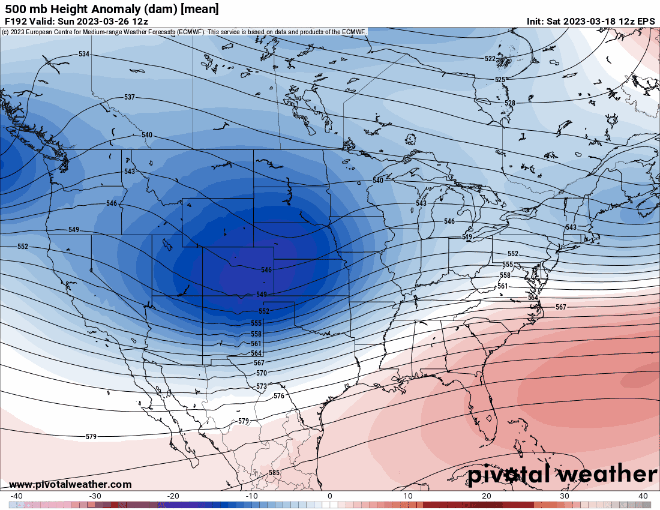
I could do without that stronger looking-nao signal and thus note the stronger ridging up towards Greenland. Can also see the building heights in the far top left and thus a more pronounced -EPO.
As far as all those telecons go they all will be negative by the weekend with the PNA falling off into.the unknown. Can't recall to often seeing it with all of them ( AO, NAO, EPO, PNA ) negative and PNA so negative. Something I think will have to give. With the MJO crashing into the COD ( phase 3 ) it leaves alot more questions going forward beyond the weekend? Basically gonna be no forcing to help things move along but for how long is the question?
-
20 minutes ago, weatherbo said:
21 degrees with light snow showers the past few hours.
Spring in the southern sub

If only those 60+ readings could sneak up here.
-
The actual total for here is 81.2"!
For March it is at 22.0" I'll check later to see where it ranks.
-
1 hour ago, Stevo6899 said:
I'd feel more comfortable if I was more out by you than in se mi. This has nw trend written all-over it if if bombs out like the gfs portrays.
Unless that MJO can make a run at 4 the nw trend thing should stay dead as it has most of this month. Ofcourse it looks to be headed into the COD next weekend and beyond so harder to say beyond that time frame. The EPO, NAO, AO look to tank later this week as well. Interesting times ahead for sure.

April 2023 General Discussion
in Lakes/Ohio Valley
Posted
The Battle Creek river is at its second highest level I have seen since moving here. The power company has power lines along parts of it they have been replacing and have a ton of these wood platforms that the river has reached and I suspect only a matter of time before they start getting carried down the river if it keeps rising which I suspect it will this week. That may cause other issues if they start blocking the flow around bridges etc..