Harry Perry
-
Posts
1,143 -
Joined
-
Last visited
Content Type
Profiles
Blogs
Forums
American Weather
Media Demo
Store
Gallery
Everything posted by Harry Perry
-

Winter 2025-26 Medium/Long Range Discussion
Harry Perry replied to michsnowfreak's topic in Lakes/Ohio Valley
Pattern is great for a good storm, but we just can’t get the northern/southern to phase where we need. Leads to messy SLP’s with marginal thermals - at least over in my neck of the woods. Looks somewhat better further west across Iowa, western Wisconsin and Minnesota but even then it ejects so fast that any snow will be a quick hitter. And what do you know, the arctic air comes back mid month with storm track across the southern US lol.
-
Hope the warm front ends up in Alpena
-
Ahh yes, the usual Michigan winter I’ve come quite accustom to… Where it’s dry and sub-zero for days followed by a sudden warmup to 33° with 2” of rain and 60 mph winds one day, then right back to sub-zero and dry for weeks.

-
Winter 2025-26 Medium/Long Range Discussion
Harry Perry replied to michsnowfreak's topic in Lakes/Ohio Valley
Been watching that as well. GFS most bullish especially out your way. Will be something to watch the next couple of days. -
If we didn't have bad luck… you know the saying lol. I found it interesting that every other Christmas Day since ~2018 has been 50°+ over here per a local met. If I get some time later I’ll check that out.
-
Winter 2025-26 Medium/Long Range Discussion
Harry Perry replied to michsnowfreak's topic in Lakes/Ohio Valley
Checked last night for the first time in days. Trying to cut back. -
You have snowpack? My yard right now

-
Well, that was fun while it lasted. Back to the regular scheduled programming relative of the last ~5 years.
-
Winter 2025-26 Medium/Long Range Discussion
Harry Perry replied to michsnowfreak's topic in Lakes/Ohio Valley
14 days out - plenty of time to turn around. I remember not long ago the GFS and Euro showing 50’s and 60’s for thanksgiving a week out and look how that turned out. -
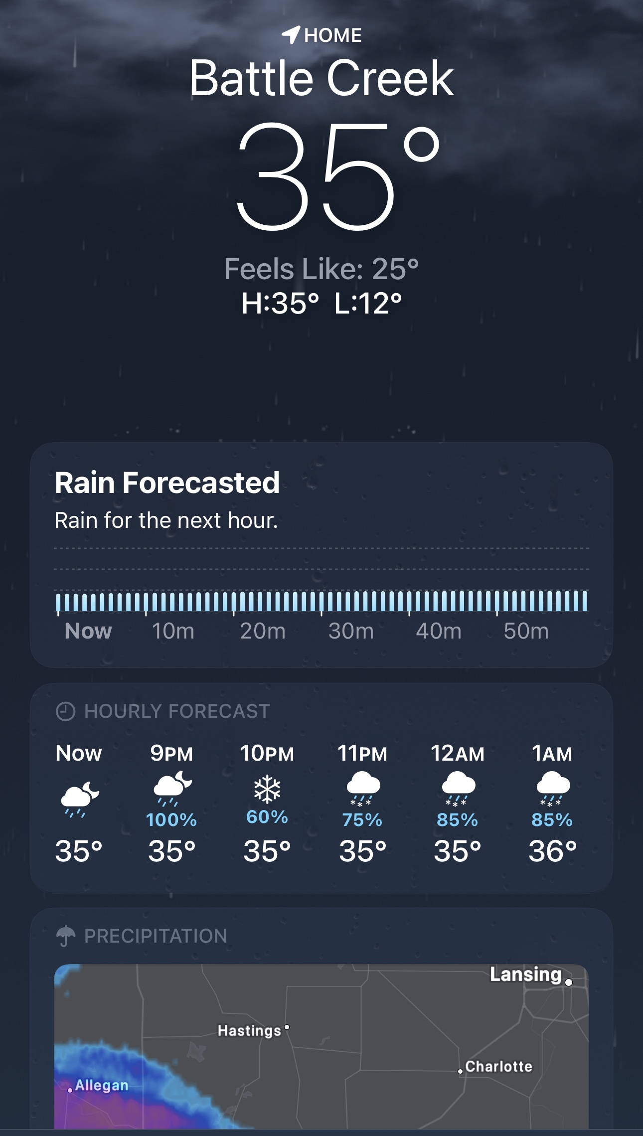
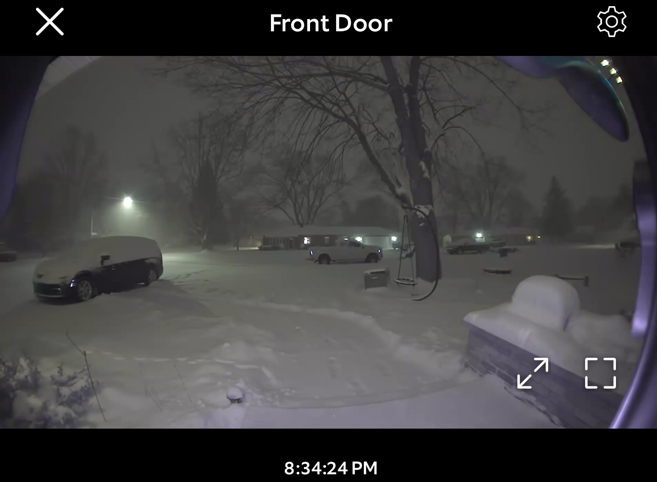
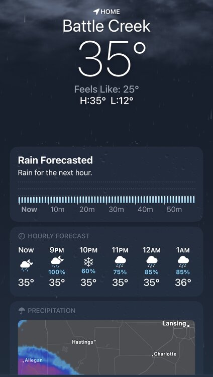
“Rain for the next hour”… Been snowing heavily since it started.
-
To be or not to be a rainer… short range says 3-6” of concrete is coming. NWS says get out your rain boots lol. I think this is going to end up being yet another surprise around here.
-
Winter 2025-26 Short Range Discussion
Harry Perry replied to SchaumburgStormer's topic in Lakes/Ohio Valley
The fact that it’s subzero and a clipper is going to bring RAIN tomorrow is comical lol. I feel a little grinch in this one. -
Dec 6-7th (It's not a clipper) Clipper
Harry Perry replied to Chicago Storm's topic in Lakes/Ohio Valley
Late to the party but over-performed here with 5.5”. Couldn’t believe the rates this morning. Quite a few accidents too. This one snuck up on a lot of people. -
Dec 6-7th (It's not a clipper) Clipper
Harry Perry replied to Chicago Storm's topic in Lakes/Ohio Valley
These clipper not clippers don’t like Lake Michigan for some reason. -
Nov 28-30th Post Turkey Day Winter Storm
Harry Perry replied to Chicago Storm's topic in Lakes/Ohio Valley
Rip city. Let’s enjoy this.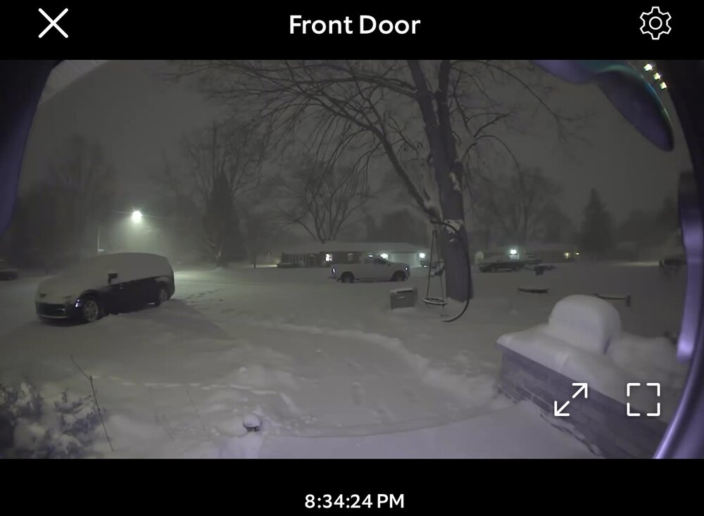
-
Nov 28-30th Post Turkey Day Winter Storm
Harry Perry replied to Chicago Storm's topic in Lakes/Ohio Valley
Has been slow to accumulate over here, finally up to an inch. Might be an under-performer. Will see if rates make up for it as we go through the evening. -
Nov 28-30th Post Turkey Day Winter Storm
Harry Perry replied to Chicago Storm's topic in Lakes/Ohio Valley
We about to be rockin’ -
Nov 28-30th Post Turkey Day Winter Storm
Harry Perry replied to Chicago Storm's topic in Lakes/Ohio Valley
Very fine pixie dust coming down, just enough for black ice on many rural roads. Started around 11:30, have a compacted half inch or so. Should be picking up here soon. -
Nov 28-30th Post Turkey Day Winter Storm
Harry Perry replied to Chicago Storm's topic in Lakes/Ohio Valley

-
Nov 28-30th Post Turkey Day Winter Storm
Harry Perry replied to Chicago Storm's topic in Lakes/Ohio Valley
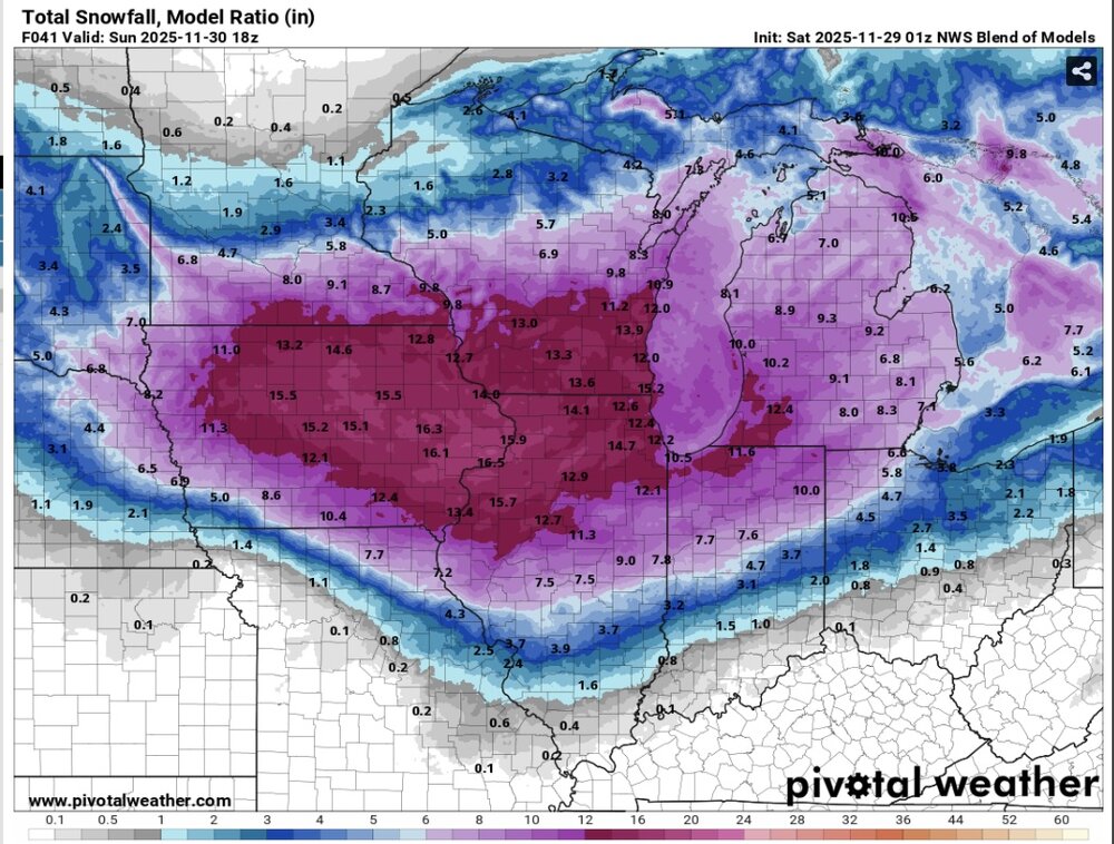
0z NAM is doing NAM things… drying out quite a bit in some of the expected higher-end areas in eastern Iowa/western Illinois. DVN goes from over a foot down to 9” this run. -
Nov 28-30th Post Turkey Day Winter Storm
Harry Perry replied to Chicago Storm's topic in Lakes/Ohio Valley
For real. I’d like to think the overnight shift would come in and hoist a warning for their entire area with the exception of maybe Huron, Tuscola and Sanilac counties. EDIT: Actually after checking over that way, nah.. warning area wide would be wise. 6-8” all the way up to Port Austin. -
Nov 28-30th Post Turkey Day Winter Storm
Harry Perry replied to Chicago Storm's topic in Lakes/Ohio Valley

- 711 replies
-
- 15
-

-

-

-
Nov 28-30th Post Turkey Day Winter Storm
Harry Perry replied to Chicago Storm's topic in Lakes/Ohio Valley
Ensembles have been juiced and most of the short range guidance (18z) is increasing qpf as well. Also trending better for the eastern side of the state. -
Nov 28-30th Post Turkey Day Winter Storm
Harry Perry replied to Chicago Storm's topic in Lakes/Ohio Valley
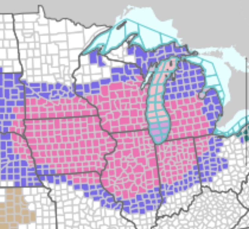
Must be contagious. First it was GRR for several years, now DTX too. I agree with you 100%. Second busiest holiday travel day in conjunction with 5-8” of snow and 30+ mph winds… just issue the warning. For many it’s the difference between waiting a day or two and just hunkering down vs. in the ditch with a wrecked vehicle or worse. Who cares if the amount of snow doesn’t specifically meet “warning” criteria, it’s irrelevant when it comes to life & safety IMO. -
Nov 28-30th Post Turkey Day Winter Storm
Harry Perry replied to Chicago Storm's topic in Lakes/Ohio Valley
I did read somewhere in one of the previous AFD’s that ratios would be as high as 16-17:1 which would be pretty impressive by November standards.